Red Castle to South Kings Loop - Utah's Uinta Mountains

Steven.reed.smith

New Member
Joined
Aug 19, 2024
Messages
3
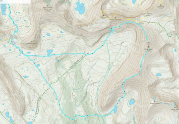
I'm planning a backpacking trip to knock out several of my remaining Uinta 13ers, including South Kings. My base camp will be at East Red Castle Lake. I plan to summit Kings and then South Kings. I know the traditional route would be just an out and back, over Kings again, but i would really like to descend the south-west spur of South Kings down to Kings Lake and return back up to Smith's Fork Pass. Wondering if anyone has attempted this spur, or has any information about it? Is this doable? I am a fairly experienced hiker. Planned route in Cyan below:
1753306079693.png
 
Never descended from South Kings that way but here is a photo from kings lake from a couple years ago if it helps. Looks steep but doesn't seem to be any cliff bands on they way down. Not sure about the route after Kings Lake though. We came from the north and then continued south to Milk Lake. It looks like you have some route lines heading north after rounding the mountain by kings lake. From there to the highline trail is super easy going and would work as an option to get you back to Smith's fork pass.

DSCF1916-X4.jpg
Awesome thankyou! Those route lines headed north are from my kings summit a couple years ago from milk lake. Wanted to try something a little different this time but have that as a backup if it doesn’t work out. I’m sure you weren’t paying attention, but by chance do you recall if those slopes looked shaley?
 
Sorry, I either wasn't paying attention or just don't recall. But I don't remember too much about how the slopes looked from that trip.
 
How's the ridge from Kings to South Kings? I've looked at it (as I suspect many of us have) from Kings but didn't have time or energy to actually do it.
 

Don't like ads? Become a BCP Supporting Member and kiss them all goodbye. Click here for more info.

Back
Top