- Joined
- Dec 23, 2013
- Messages
- 4,114
I hooked up with Backcountrypost member @regehr bright and early Saturday morning to attempt to follow the ridge lines around Red Butte Canyon. My daughter and I had attempted to reach Lookout Peak three weeks earlier but were turned back due to deep snow at Knowlton's Fork. Regehr had read my trip report and suggested the rim-walk around the canyon, as this was an item still on his bucket list that he had yet to check off.
We began our route at the Mount Wire Trailhead at 6:45 am. Once on top of Mount Wire, we proceeded to hike east along the ridge towards the head of Red Butte Canyon. When we reached the end of the ridge, we bushwhacked down into the canyon proper where we were able to pick up the trail that led us to an old roadbed that we followed to gain access to the Black Mountain Ridge (I believe that locals may refer to it as Little Black Mountain).
Once on the ridge, we stopped for a quick lunch before heading west along the Black Mountain Ridge. The first 2.5 - 3.0 miles is an intense thrash as one makes their way along the ridgeline. Fortunately, there was still some snow on the north side of the ridge that we took advantage of from time to time as we made our way along. Eventually, we ran into the Smuggler's Gap Trail that comes up out of City Creek Canyon and we were glad to at last be back on a trail. Along the section where we hiked the ridge, we encountered some scrambling and a slight bit of exposure. Approximately four miles along the ridge we dropped down off-trail to access the Mount Van Cott ridgeline. Once on the Van Cott ridgeline, we followed it to Mount Van Cott and then out to the trailhead.
The total distance of our hike was a touch over 17.5 miles and it took us nearly 12 hours to complete. I was pretty tired when all was said and done. Here are some shots of our trek.

@regehr on his way up Mount Wire

A look across to the north of the Black Mountain Ridge where we will be later on in the day

Bushwhacking down off the Mount Wire Ridge into Red Butte Canyon

Yet to bloom Mule's Ear along our route

The old road cut at the head of Red Butte Canyon

On the old road bed

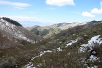
View down into Red Butte Canyon - less snow than three weeks ago

A look back at the Mount Wire Ridge which we had just traversed

First major snow encountered as we are about to drop down into Knowlton's Fork

@regehr hiking along the old roadbed in Knowlton's Fork

A look down into Knowlton's Fork

On the Black Mountain Ridgeline

Great views of Grandview Peak along the ridge

Snow, helping us out a bit at this point

The beginning of the first scrambling section

Back into the nasty stuff

Making our way through scrub oak

A look back along the ridge that we had hiked plus a bright Grandview Peak and upper City Creek Basin

A look down into City Creek Canyon - the water treatment plant is visible

More scrambling to contend with

The Mount Van Cott Ridgeline that we are dropping down to

Red Butte Reservoir and Mount Wire
 Mount Van Cott straight ahead
The end.
We began our route at the Mount Wire Trailhead at 6:45 am. Once on top of Mount Wire, we proceeded to hike east along the ridge towards the head of Red Butte Canyon. When we reached the end of the ridge, we bushwhacked down into the canyon proper where we were able to pick up the trail that led us to an old roadbed that we followed to gain access to the Black Mountain Ridge (I believe that locals may refer to it as Little Black Mountain).
Once on the ridge, we stopped for a quick lunch before heading west along the Black Mountain Ridge. The first 2.5 - 3.0 miles is an intense thrash as one makes their way along the ridgeline. Fortunately, there was still some snow on the north side of the ridge that we took advantage of from time to time as we made our way along. Eventually, we ran into the Smuggler's Gap Trail that comes up out of City Creek Canyon and we were glad to at last be back on a trail. Along the section where we hiked the ridge, we encountered some scrambling and a slight bit of exposure. Approximately four miles along the ridge we dropped down off-trail to access the Mount Van Cott ridgeline. Once on the Van Cott ridgeline, we followed it to Mount Van Cott and then out to the trailhead.
The total distance of our hike was a touch over 17.5 miles and it took us nearly 12 hours to complete. I was pretty tired when all was said and done.
Here are some shots of our trek.@regehr on his way up Mount Wire
A look across to the north of the Black Mountain Ridge where we will be later on in the day
Bushwhacking down off the Mount Wire Ridge into Red Butte Canyon
Yet to bloom Mule's Ear along our route
The old road cut at the head of Red Butte Canyon
On the old road bed
View down into Red Butte Canyon - less snow than three weeks ago
A look back at the Mount Wire Ridge which we had just traversed
First major snow encountered as we are about to drop down into Knowlton's Fork
@regehr hiking along the old roadbed in Knowlton's Fork
A look down into Knowlton's Fork
On the Black Mountain Ridgeline
Great views of Grandview Peak along the ridge
Snow, helping us out a bit at this point
The beginning of the first scrambling section
Back into the nasty stuff
Making our way through scrub oak
A look back along the ridge that we had hiked plus a bright Grandview Peak and upper City Creek Basin
A look down into City Creek Canyon - the water treatment plant is visible
More scrambling to contend with
The Mount Van Cott Ridgeline that we are dropping down to
Red Butte Reservoir and Mount Wire
Mount Van Cott straight ahead The end.