SteveR
Member
- Joined
- Sep 22, 2016
- Messages
- 1,046
October usually marks the onset of cooler fall weather in Calgary- for Jo and I that means it's time for our annual trip to the desert for a couple extra weeks of summer. This year, an unusually cold and wet September made us even more eager to head south. With yet another way too early snowstorm nipping at our heels- we fled south from Alberta on September 29.

October 1, our first desert morning, at a favourite spot. What follows is an abridged version of my original, much more wordy and photo heavy trip report, which somehow vanished into the BCP ether as I worked on it yesterday between bouts of "real work" in my home office.
First on the agenda was Moonshine wash:


Chilling in lower Moonshine. The descent was so entertaining that rather than loop around on top, we want back up-canyon for double the fun.

Evening near the Colonnade Arch trailhead, after solar showers and happy hour.


We had planned on hiking beyond Collonade out to Bowknot Bend, before a tire problem and approaching rain became issues.
The following day was wet, making sticking to the pavement in Capitol Reef the best idea, rather than Upper Muley Twist. After picking apples and doing a couple of "tourist walks"- the rain let up and we did a short hike out Cohab from the east end to the two Fruita viewpoints, which we had never been to before.


The sun returned following a damp night at Deer Creek. We explored some of the nearby ridges to the south.


There is plenty of scope for further wandering here. Now that we have a good idea of the lay of the land- we'll be back!
A night of intense lightning storms overhead our camp along the Old Sheffield Road, yielded to morning clearing. Not far away- we hiked across a prominent dome/escarpment and looped back around below it, visiting a nice panel along the way. A great hike!


Approaching the summit block.


Our friends Larry and Karen were also road tripping the Utah desert- we hooked up for two days of hiking together. Bighorn Canyon was on their wish list- it was the second time for Jo and I, but well worth revisiting.


The following days forecast was not promising- rain before noon, calling for a short morning hike:


100 Hands. A brief shower came and went. We squeezed in the day's second hike, to a nearby destination, before the rain began in earnest later that afternoon.


That white dome above was our venue from two days previously. Saying our goodbyes to our friends, who were heading north, we left Escalante in driving rain, ending up near Kanab for the night. What to do on a wet Sunday in Kanab? First off- Coyote South permits (there were only 9 applicants), then groceries, a coffee shop, the visitor centre. That's about it!
Onwards to camp in the Sand Hills , via a snowy Jacob's Lake.
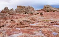
The next morning -Coyote Buttes South under mixed skies.


We had been here two years ago. Wandering around somewhat aimlessly, we found most of the same features as before, and a new one.


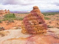
Rain began at the teepees, but putting a positive spin on things- gave a nice soft glow to the rock.


A break in the wet weather led us further west, where we "discovered" a zone of interesting fins and lace rock.


Too soon- a black wall began approaching from the north. We fled the area with just enough time to make it back to the truck as the deluge arrived. Rather than wait it out there, we decided to take the shortcut over to White Pockets, which was already on the menu for the next day, with thoughts of a nice sunset if the clouds lifted as forecast.

Rain continued off and on through our 3 hour ramble though White Pockets.


Glad that I had my weather sealed Pentax DSLR!


The iconic tree.

Well- the sunset was a dud, as the clouds stayed put. We left the flooded trailhead parking area and spent a second night at our favourite camp site, further west.
We could have returned to White Pockets in the morning, but having also been there in 2013, we opted instead for a stroll down Buckskin to Edmaiers "secret" which was new to us.

The walk down the wash was enjoyable on it's own, with the bonus of yet another colourful and very interesting area to wander at will in.


Wrapping up our loop through Edmaiers- we encountered some other hikers who had come in via a more direct route- over a ridge from between Buckskin and Wire Pass trailheads.
They also delivered some bad news, we would enjoy one more dry day, then- more rain! On the move after a night at Ponderosa Grove, we headed for St. George with the promise of more warmth, and the rain holding off a bit longer. A return to Yant Flats Cliffs made sense for what looked like our final dry day.


We looped around, taking a winding lower line on the way east, then back higher up close to the escarpment on the return.

By later in the afternoon, high thin clouds were beginning to blanket the southern skyline. Waking up to steady rain after overnighting to the north of Yant, we pulled the plug a day early and started our 18 hour trek back to Alberta. Overall, despite some weather setbacks- another great October desert memory!
Full album and more blather, here:
https://steveriggs.smugmug.com/Utah2018/
October 1, our first desert morning, at a favourite spot. What follows is an abridged version of my original, much more wordy and photo heavy trip report, which somehow vanished into the BCP ether as I worked on it yesterday between bouts of "real work" in my home office.
First on the agenda was Moonshine wash:
Chilling in lower Moonshine. The descent was so entertaining that rather than loop around on top, we want back up-canyon for double the fun.
Evening near the Colonnade Arch trailhead, after solar showers and happy hour.
We had planned on hiking beyond Collonade out to Bowknot Bend, before a tire problem and approaching rain became issues.
The following day was wet, making sticking to the pavement in Capitol Reef the best idea, rather than Upper Muley Twist. After picking apples and doing a couple of "tourist walks"- the rain let up and we did a short hike out Cohab from the east end to the two Fruita viewpoints, which we had never been to before.
The sun returned following a damp night at Deer Creek. We explored some of the nearby ridges to the south.
There is plenty of scope for further wandering here. Now that we have a good idea of the lay of the land- we'll be back!
A night of intense lightning storms overhead our camp along the Old Sheffield Road, yielded to morning clearing. Not far away- we hiked across a prominent dome/escarpment and looped back around below it, visiting a nice panel along the way. A great hike!
Approaching the summit block.
Our friends Larry and Karen were also road tripping the Utah desert- we hooked up for two days of hiking together. Bighorn Canyon was on their wish list- it was the second time for Jo and I, but well worth revisiting.
The following days forecast was not promising- rain before noon, calling for a short morning hike:
100 Hands. A brief shower came and went. We squeezed in the day's second hike, to a nearby destination, before the rain began in earnest later that afternoon.
That white dome above was our venue from two days previously. Saying our goodbyes to our friends, who were heading north, we left Escalante in driving rain, ending up near Kanab for the night. What to do on a wet Sunday in Kanab? First off- Coyote South permits (there were only 9 applicants), then groceries, a coffee shop, the visitor centre. That's about it!
Onwards to camp in the Sand Hills , via a snowy Jacob's Lake.
The next morning -Coyote Buttes South under mixed skies.
We had been here two years ago. Wandering around somewhat aimlessly, we found most of the same features as before, and a new one.
Rain began at the teepees, but putting a positive spin on things- gave a nice soft glow to the rock.
A break in the wet weather led us further west, where we "discovered" a zone of interesting fins and lace rock.
Too soon- a black wall began approaching from the north. We fled the area with just enough time to make it back to the truck as the deluge arrived. Rather than wait it out there, we decided to take the shortcut over to White Pockets, which was already on the menu for the next day, with thoughts of a nice sunset if the clouds lifted as forecast.
Rain continued off and on through our 3 hour ramble though White Pockets.
Glad that I had my weather sealed Pentax DSLR!
The iconic tree.
Well- the sunset was a dud, as the clouds stayed put. We left the flooded trailhead parking area and spent a second night at our favourite camp site, further west.
We could have returned to White Pockets in the morning, but having also been there in 2013, we opted instead for a stroll down Buckskin to Edmaiers "secret" which was new to us.
The walk down the wash was enjoyable on it's own, with the bonus of yet another colourful and very interesting area to wander at will in.
Wrapping up our loop through Edmaiers- we encountered some other hikers who had come in via a more direct route- over a ridge from between Buckskin and Wire Pass trailheads.
They also delivered some bad news, we would enjoy one more dry day, then- more rain! On the move after a night at Ponderosa Grove, we headed for St. George with the promise of more warmth, and the rain holding off a bit longer. A return to Yant Flats Cliffs made sense for what looked like our final dry day.
We looped around, taking a winding lower line on the way east, then back higher up close to the escarpment on the return.
By later in the afternoon, high thin clouds were beginning to blanket the southern skyline. Waking up to steady rain after overnighting to the north of Yant, we pulled the plug a day early and started our 18 hour trek back to Alberta. Overall, despite some weather setbacks- another great October desert memory!
Full album and more blather, here:
https://steveriggs.smugmug.com/Utah2018/
Attachments
Last edited:
