wabenho
Member
- Joined
- Sep 18, 2017
- Messages
- 138
I have hesitated to write this trip report because things did not turn out as I hoped, and I was pretty disappointed. In the interest of sharing a little information on a trail that I struggled to find beta on, I thought I should post a few words and pictures. I have also appreciated when others on this site have shared their experiences when things did not go exactly as planned. This TR will probably be more of an informational read than an enjoyable one. If you are only interested in information about trail conditions of Rock Creek Trailhead to Rainbow Lake, you can stop reading after the last picture. After that the text tells the story of my plans changing.
After a beautiful early morning drive through the small towns of Francis, Hanna, and Tabiona, UT, I arrived at the Rock Creek Trailhead at the base of Upper Stillwater Reservoir. It was the day after Labor Day and I was the only car in the lot. I threw on my pack and headed up the trail.
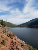
After a short climb to the top of the dam, the trail levels off and follows the bank of the reservoir for about 2 miles. This section is very rocky, and the signs say it is closed from November to June each year due to falling rock. I’m guessing it is the freeze/thaw cycle that increases the danger of falling rock.
Rocky trail along Upper Stillwater looking towards the Head of Rock Creek
After leaving the banks of the Upper Stillwater, the trail proceeds through forest for about a mile to the Wilderness Boundary and a trail junction. The entire section of trail to this point appears to be heavily used by cows/cowboys, although I saw neither, just tracks.
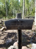
At this trail fork, a right takes you up the Rock Creek Trail proper, along the main fork of Rock Creek and a left takes you up the West Fork Rock Creek Trail. The junction is well signed. This section and the Fish Creek section of trail, I had trouble finding info about prior to my trip. Although appearing much less travelled, the trail was in good shape. It was easy to follow and there were only a few instances of downfall/snags that needed to be navigated. This section of trail continued for about 3 miles, steadily gaining elevation along the steep banks of the clear waters of West Fork Rock Creek which drains the Grandaddy Basin.
Sign at junction of Rock Creek trail and West Fork Rock Creek Trail (looking south - my directions above are from the perspective of traveling north the the right/left are switched)
Near the 3-mile mark of West Fork Rock Creek (mile 6 from the TH) I arrived the confluence of West Fork Rock Creek and Fish Creek and stopped for lunch. The confluence of the creek also marks the confluence of trails. From this point you can continue following the West Fork Rock Creek trail (not shown on all maps) to the southern end of Grandaddy Basin or take the Fish Creek Trail to the northern end of Grandaddy.
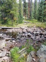
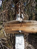
My destination for this night was Rainbow Lake, so I took the Fish Creek trail. The actual trail fork comes after crossing West Fork Rock Creek and is well signed. I was able to cross the creek here without wetting my trail runners, but keep in mind that this was early September in a dry year.
Crossing of West Fork Rock Creek near confluence with Fish Creek
Sign at intersection of West Fork Rock Creek Trail and Fish Creek Trail (looking northwest
Fish Creek trail was very similar to West Fork Rock Creek trail in that it did not appear to be frequently used, but it was well maintained, and I only encountered a few more downed trees/snags to navigate around. The trail climbs along the creek at first before leveling off and traversing through a mix of pine forest and small meadows. After about 3.5 to 4 miles of travel along Fish Creek I arrived at Rainbow Lake in the northeast corner of Grandaddy Basin.
Indications of trail maintenance

Some downfall over the trail, but only a few instances and easy to go around/over

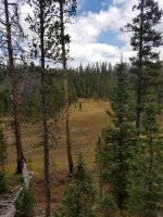
Typical terrain of the area
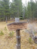
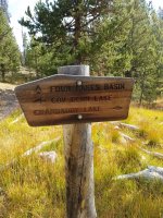
On the east side of Rainbow there are a couple of trail junctions. On the southeast side of the lake the Fish Creek trail meets up with the Hades-Rocky Sea Trail. Going south on Hades-Rocky Sea will take you south to Grandaddy Lake proper and eventually Hades Pass and Grandview TH. The Fish Creek Trail and Hades-Rocky Sea Trail become one trail for a short distance around the east side of Rainbow Lake. On the northeast side of the lake the trails separate again, and the Fish Creek Trail continues west to Governor Dern and Pinto Lakes in the northwest portion of the basin. The Hades-Rocky Sea Trail takes you north to the Four Lakes Basin, and you guessed it, Rocky Sea Pass. This was the trail I wanted in the morning. I scouted it out and then set off to find a campsite for the night.
Southern Junction of Fish Creek Trail and the Hades-Rocky Sea Trail (looking west)
Northern junction of Fish Creek Trail and Hades-Rocky Sea Trail (looking north)
After looking over the terrain, I set off cross-country along the north side of Rainbow Lake. I found a nice spot on the northwest corner of the lake near where a spring comes into the lake. There may be more spots on the south shore of Rainbow, but the north side of this lake did not have the normal Unitas fire-ring garden, that I have seen at other lakes. I could tell that others had camped in the spot I chose, but just barely.
After choosing the spot, I set up camp and headed down to the lake for some fishing. Up to this point of the trip, it seemed like everything was going great, but as I started fishing, something started to change. I didn’t notice much at first, but it started with a feeling that I wasn’t really enjoying myself. The fishing wasn’t hot, but I was catching a few brookies, enough to normally keep me interested. It was odd because backpacking in the Uintas and fishing those backcountry lakes are some of my favorite things in the world. I kind of shrugged the feeling off and headed back to camp for some dinner.
I cooked a homemade backcountry meal, same recipe as I had enjoyed many times, and sat on a log to enjoy. I noticed that as I was eating that I was a little stuffed up. You know that feeling when you can’t really breathe through your nose, so you have to stop chewing and take a breath through your mouth? Again, I shrugged it off, attributing it to mild allergies I sometimes get.
After dinner, I walked back down to the lake. It was beautiful – the sun was setting and there were some ducks gliding across the water. I remember thinking it was nice, but I did not have that exhilarating/restorative feeling that I normally feel on a backcountry trip, especially on the first night. As I am going through the pictures, I’m noticing I hardly took any. At this point I also started to feel a little anxious. I found myself worrying more than normal about all kinds of things: family at home, forest fires, lightning… I normally love the solitude of a solo backcountry trip, but I was wishing for some company right about now. I was also starting to feel tired, so I shrugged it off again and decided to turn in early. I climbed in my bag and read for a bit.
My anxiety eased a little as I became involved in my book. Eventually I put the book down and decided to try for some sleep. I never have much trouble sleeping, but this night I could just not get there. I was tossing and turning, and my nose was now fully clogged. I also started to get cold despite the temps being relatively mild. It was only now that I was realizing that I was getting sick.
I spent the next several hours simultaneously sweating/shivering and generally feeling miserable. I also became more anxious thinking about the possibility of being the only person for 5 or 10 miles and my illness preventing me from getting out on my own. I even considered packing up and heading out in the middle of the night, since I wasn’t sleeping anyway. I eventually decided that this was a risky choice and decided against it. Finally, in the wee hours of the morning, I passed out for a little bit of sleep.
When I awoke, I actually felt a little better. I got up and cooked breakfast and was feeling OK. Now I had a tough decision: to continue on or to head back to the car. I had been looking forward to this trip for a while and it is not easy for me to get away from work and family responsibilities, so I really wanted to push on. After much deliberation, I decided to play it safe and bail. In the end, I decided I did not want to spend another night like the last and it seemed foolish to get deeper into the backcountry knowing I was somewhat compromised.
I hiked out the same way I came in, so not much to report. It took me significantly longer to hike out, which is telling since it was all downhill. By the time I got back to my car, I was feeling pretty crappy. I bee-lined it down to Duchesne and booked it home. When I arrived home, I crashed. I still felt miserable, but I was glad to be in a comfortable bed with a roof and four walls.
"Live to fight another day"... I guess.
After a beautiful early morning drive through the small towns of Francis, Hanna, and Tabiona, UT, I arrived at the Rock Creek Trailhead at the base of Upper Stillwater Reservoir. It was the day after Labor Day and I was the only car in the lot. I threw on my pack and headed up the trail.
After a short climb to the top of the dam, the trail levels off and follows the bank of the reservoir for about 2 miles. This section is very rocky, and the signs say it is closed from November to June each year due to falling rock. I’m guessing it is the freeze/thaw cycle that increases the danger of falling rock.
Rocky trail along Upper Stillwater looking towards the Head of Rock Creek

After leaving the banks of the Upper Stillwater, the trail proceeds through forest for about a mile to the Wilderness Boundary and a trail junction. The entire section of trail to this point appears to be heavily used by cows/cowboys, although I saw neither, just tracks.
At this trail fork, a right takes you up the Rock Creek Trail proper, along the main fork of Rock Creek and a left takes you up the West Fork Rock Creek Trail. The junction is well signed. This section and the Fish Creek section of trail, I had trouble finding info about prior to my trip. Although appearing much less travelled, the trail was in good shape. It was easy to follow and there were only a few instances of downfall/snags that needed to be navigated. This section of trail continued for about 3 miles, steadily gaining elevation along the steep banks of the clear waters of West Fork Rock Creek which drains the Grandaddy Basin.
Sign at junction of Rock Creek trail and West Fork Rock Creek Trail (looking south - my directions above are from the perspective of traveling north the the right/left are switched)

Near the 3-mile mark of West Fork Rock Creek (mile 6 from the TH) I arrived the confluence of West Fork Rock Creek and Fish Creek and stopped for lunch. The confluence of the creek also marks the confluence of trails. From this point you can continue following the West Fork Rock Creek trail (not shown on all maps) to the southern end of Grandaddy Basin or take the Fish Creek Trail to the northern end of Grandaddy.
My destination for this night was Rainbow Lake, so I took the Fish Creek trail. The actual trail fork comes after crossing West Fork Rock Creek and is well signed. I was able to cross the creek here without wetting my trail runners, but keep in mind that this was early September in a dry year.
Crossing of West Fork Rock Creek near confluence with Fish Creek

Sign at intersection of West Fork Rock Creek Trail and Fish Creek Trail (looking northwest

Fish Creek trail was very similar to West Fork Rock Creek trail in that it did not appear to be frequently used, but it was well maintained, and I only encountered a few more downed trees/snags to navigate around. The trail climbs along the creek at first before leveling off and traversing through a mix of pine forest and small meadows. After about 3.5 to 4 miles of travel along Fish Creek I arrived at Rainbow Lake in the northeast corner of Grandaddy Basin.
Indications of trail maintenance

Some downfall over the trail, but only a few instances and easy to go around/over

Typical terrain of the area

On the east side of Rainbow there are a couple of trail junctions. On the southeast side of the lake the Fish Creek trail meets up with the Hades-Rocky Sea Trail. Going south on Hades-Rocky Sea will take you south to Grandaddy Lake proper and eventually Hades Pass and Grandview TH. The Fish Creek Trail and Hades-Rocky Sea Trail become one trail for a short distance around the east side of Rainbow Lake. On the northeast side of the lake the trails separate again, and the Fish Creek Trail continues west to Governor Dern and Pinto Lakes in the northwest portion of the basin. The Hades-Rocky Sea Trail takes you north to the Four Lakes Basin, and you guessed it, Rocky Sea Pass. This was the trail I wanted in the morning. I scouted it out and then set off to find a campsite for the night.
Southern Junction of Fish Creek Trail and the Hades-Rocky Sea Trail (looking west)

Northern junction of Fish Creek Trail and Hades-Rocky Sea Trail (looking north)

After looking over the terrain, I set off cross-country along the north side of Rainbow Lake. I found a nice spot on the northwest corner of the lake near where a spring comes into the lake. There may be more spots on the south shore of Rainbow, but the north side of this lake did not have the normal Unitas fire-ring garden, that I have seen at other lakes. I could tell that others had camped in the spot I chose, but just barely.
After choosing the spot, I set up camp and headed down to the lake for some fishing. Up to this point of the trip, it seemed like everything was going great, but as I started fishing, something started to change. I didn’t notice much at first, but it started with a feeling that I wasn’t really enjoying myself. The fishing wasn’t hot, but I was catching a few brookies, enough to normally keep me interested. It was odd because backpacking in the Uintas and fishing those backcountry lakes are some of my favorite things in the world. I kind of shrugged the feeling off and headed back to camp for some dinner.
I cooked a homemade backcountry meal, same recipe as I had enjoyed many times, and sat on a log to enjoy. I noticed that as I was eating that I was a little stuffed up. You know that feeling when you can’t really breathe through your nose, so you have to stop chewing and take a breath through your mouth? Again, I shrugged it off, attributing it to mild allergies I sometimes get.
After dinner, I walked back down to the lake. It was beautiful – the sun was setting and there were some ducks gliding across the water. I remember thinking it was nice, but I did not have that exhilarating/restorative feeling that I normally feel on a backcountry trip, especially on the first night. As I am going through the pictures, I’m noticing I hardly took any. At this point I also started to feel a little anxious. I found myself worrying more than normal about all kinds of things: family at home, forest fires, lightning… I normally love the solitude of a solo backcountry trip, but I was wishing for some company right about now. I was also starting to feel tired, so I shrugged it off again and decided to turn in early. I climbed in my bag and read for a bit.
My anxiety eased a little as I became involved in my book. Eventually I put the book down and decided to try for some sleep. I never have much trouble sleeping, but this night I could just not get there. I was tossing and turning, and my nose was now fully clogged. I also started to get cold despite the temps being relatively mild. It was only now that I was realizing that I was getting sick.
I spent the next several hours simultaneously sweating/shivering and generally feeling miserable. I also became more anxious thinking about the possibility of being the only person for 5 or 10 miles and my illness preventing me from getting out on my own. I even considered packing up and heading out in the middle of the night, since I wasn’t sleeping anyway. I eventually decided that this was a risky choice and decided against it. Finally, in the wee hours of the morning, I passed out for a little bit of sleep.
When I awoke, I actually felt a little better. I got up and cooked breakfast and was feeling OK. Now I had a tough decision: to continue on or to head back to the car. I had been looking forward to this trip for a while and it is not easy for me to get away from work and family responsibilities, so I really wanted to push on. After much deliberation, I decided to play it safe and bail. In the end, I decided I did not want to spend another night like the last and it seemed foolish to get deeper into the backcountry knowing I was somewhat compromised.
I hiked out the same way I came in, so not much to report. It took me significantly longer to hike out, which is telling since it was all downhill. By the time I got back to my car, I was feeling pretty crappy. I bee-lined it down to Duchesne and booked it home. When I arrived home, I crashed. I still felt miserable, but I was glad to be in a comfortable bed with a roof and four walls.
"Live to fight another day"... I guess.
Last edited:
