PSA: Zion NP off-limit Research Natural Areas

fossana

Member
Joined
Jan 11, 2018
Messages
977
I was doing some digging around about Zion NP Research Natural Areas this weekend based off a note in Courtney Purcell's Zion NP Summit Routes book and thought I would share the info since it's buried online and somewhat vague. Previously I knew about Parunuweap from Joe Braun's site, but not the others and I've seen various TRs (on other sites) where the authors unknowingly hiked or put up a climbing route in the RNAs.

The best written description I could find is in the Zion NP 36 CFR 1.7(b), Compendium 2016 starting on page 8:

Kolob Mesas: Mesa tops of Timber Top Mountain and Nagunt Mesa overlooking the Kolob Canyons. Also includes the canyon draining west from Timber Top Mountain.

Shune’s Creek: Shune’s Creek Canyon below the Navajo Sandstone cliffs along the southern boundary of the park, excluding the administrative zone around the water right diversion.

Hanging Garden: Five hanging gardens in Zion and Parunuweap Canyons. Includes the immediate vicinities of Grotto Spring, Weeping Rock, Sinawava Hanging Garden, and two unnamed springs in Parunuweap Canyon.

Isolated Mesa Tops: Isolated mesa tops that are surrounded by high cliffs of Navajo Sandstone. These include Burnt Mountain (south of La Verkin Creek), Greatheart Mesa, Inclined Temple, four unnamed high mesas west of Horse Pasture Plateau, and two closely associated unnamed mesas north of Wynopits Mountain.

Goose Creek: The sandstone slot canyons of Goose Creek, which drains east from Lava Point and Horse Pasture Plateau. A five-mile long tributary of the North Fork of the Virgin River with deep narrow canyons and perennial stream flow in the lower reaches.

Crazy Quilt Mesa: The top of Crazy Quilt Mesa and adjacent slopes, west of Checkerboard Mesa

Slickrock: An area of slickrock buttes, slopes and traverses, south of Clear Creek, east of Gifford Canyon and around the head of Crawford Wash.

Southeast Pinyon Juniper: An area of relatively deep sandy soils supporting relict pinyon-juniper forests in the southeastern most corner of the park.

Parunuweap: Includes Parunuweap and most of Shune’s Creek Canyons below the Navajo Sandstone, and Transview Mountain above the Navajo Sandstone.

map source
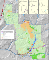
rna.png
 
Thanks for finding this and sharing. As far as maps goes Joe Braun also has been my best source for when one of his routes comes near a Research Area. When I went to Parunuweap Pass I saw some people on the top of a peak to the west and thought "I don't think they should be there." When I saw where you got to, above Gifford I, was thinking you were on the fringes of the RSA (as with Paranuweap Pass). But connecting those two points is closed..(?) Have you ever gone up the canyon at the Court of the Patriarchs and seen that ladder? It is a hanging garden but doesn't seem included specifically in the link you provided. I have seen a picture of a person repelling right by it.
 
As far as I can tell from the map, much but not all of the Jenny Peak ridgeline is closed. It would be nice it were overlaid on a USGS topo. I haven't been seen that ladder or explored that area behind Court of the Patriarchs.
 
As far as I can tell from the map, much but not all of the Jenny Peak ridgeline is closed. It would be nice it were overlaid on a USGS topo. I haven't been seen that ladder or explored that area behind Court of the Patriarchs.
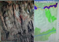
I put the Research Area map along side Google Earth. Trying to assess the borders of the closed area. To me it looks the farthest south point is even with where Crawford Wash comes in. Then it diagonals northwest over to Gifford, probably along a natural drainage high spot (?). What I am seeing is the area directly south of Gifford and the end of the ridge to the east is open wilderness. Looks like interesting territory to explore, if I can figure out that ramp you climbed along. Thanks again for finding this map.
IMG_1300.jpg
 
Last edited:
The vegetated ramp starts almost at the southern end of Gifford Canyon, somewhat close to (but across canyon from) where the drainage between Roof and Hepworth Peak drain into Gifford Canyon.
 
It turns out that since April of this year, the NPS has also closed the Cave Valley area. While it's not a Research Natural Area like these other zones, it is nonetheless closed to visitation pending further assessment to protect cultural resources. The map included with the closure notice shows that some of the nearby slickrock is also off-limits.

It's a bit frustrating that the NPS makes it so difficult to figure out which areas are closed---particularly Cave Valley, which, unlike the Research Natural Areas, is easily accessible to even casual visitors.

Regarding the Research Natural Areas mentioned in the original discussion from 4 years ago, the NatGeo Trails Illustrated topo map for Zion NP outlines them in maroon, even in the free online preview at the NatGeo website. This is probably the best map that I've found of those areas, especially the one near Crawford Wash.

The good news is that as I review the most recent Superintendent's Compendium from August 2022, the boundaries of the Research Natural Areas (listed in Sec. (a)(1)(xii) on page 9 of the Compendium) appear to be unchanged relative to 2018.
 
Thanks for the update. This map is pretty clear. Why can't the park service make the rest of the areas/maps as clear?:thinking:
 
It turns out that since April of this year, the NPS has also closed the Cave Valley area. While it's not a Research Natural Area like these other zones, it is nonetheless closed to visitation pending further assessment to protect cultural resources. The map included with the closure notice shows that some of the nearby slickrock is also off-limits.

It's a bit frustrating that the NPS makes it so difficult to figure out which areas are closed---particularly Cave Valley, which, unlike the Research Natural Areas, is easily accessible to even casual visitors.

Regarding the Research Natural Areas mentioned in the original discussion from 4 years ago, the NatGeo Trails Illustrated topo map for Zion NP outlines them in maroon, even in the free online preview at the NatGeo website. This is probably the best map that I've found of those areas, especially the one near Crawford Wash.

The good news is that as I review the most recent Superintendent's Compendium from August 2022, the boundaries of the Research Natural Areas (listed in Sec. (a)(1)(xii) on page 9 of the Compendium) appear to be unchanged relative to 2018.
I'm stunned it took them this long to close cave valley. That place always felt like a bad mix of cultural resources, private property, and easy access to stay open long. Hopefully they put actual work into making it known to be closed. i feel with these other places, people that go there will stumble across the closures at some point (much like those climbers in the first message), but cave valley definitely wont.
 
Natural study areas, etc. .... Just another way to lock you out of public lands so they do t have to deal with people
 
I'm stunned it took them this long to close cave valley. That place always felt like a bad mix of cultural resources, private property, and easy access to stay open long. Hopefully they put actual work into making it known to be closed. i feel with these other places, people that go there will stumble across the closures at some point (much like those climbers in the first message), but cave valley definitely wont.
I went there at the end of June before I knew of the closure. I didn't come across any notices of the closure until I reached the gate about a quarter-mile from the road (and only a short distance from the cultural sites). While the sign on the gate said that the area ahead was closed, it gave no indication that the closure extended all the way back to the road and onto the slickrock above. If the NPS is serious about this closure, it should probably close the nearby pullout parking and post no-entry signs there. I suspect that non-existent parking is a more effective deterrent than a sign on an unmonitored gate.

While I respect the need to protect cultural sites from vandalism, I do hope that the park will restore access to the slickrock on top of Cave Knoll (which, to my knowledge, does not have any sensitive sites).
sounds about right for closures in that area. Those pullouts are rough because they're parking for lamb's knoll too, so closing those could cause unforseen issues. We'll see. That cave knoll slickrock though would be cool to keep open.
 
It looks like there's a a new version of the compendium from 2022. The old one has been removed. The RNAs appear to be unchanged. Unfortunately, I still can't find a better map of the areas.

Kolob Mesas: Mesa tops of Timber Top Mountain and Nagunt Mesa overlooking the Kolob Canyons. Also includes the canyon draining west from Timber Top Mountain.


Shune’s Creek: Shune’s Creek Canyon below the Navajo Sandstone cliffs along the southern boundary of the park, excluding the administrative zone around the water right diversion.

Hanging Garden: Five hanging gardens in Zion and Parunuweap Canyons. Includes the immediate vicinities of Grotto Spring, Weeping Rock, Sinawava Hanging Garden, and two unnamed springs in Parunuweap Canyon.

Isolated Mesa Tops: Isolated mesa tops that are surrounded by high cliffs of Navajo Sandstone. These include Burnt Mountain (south of La Verkin Creek), Greatheart Mesa, Inclined Temple, Church Mesa, three unnamed high mesas west of Horse Pasture Plateau, and two closely associated unnamed mesas north of Wynopits Mountain.

Goose Creek: The sandstone slot canyons and canyon walls of Goose Creek, which drains east from Lava Point and Horse Pasture Plateau. A five-mile long tributary of the North Fork of the Virgin River with deep narrow canyons and perennial stream flow in the lower reaches.

Crazy Quilt Mesa: The top of Crazy Quilt Mesa and adjacent slopes, west of Checkerboard Mesa Slickrock: An area of slickrock buttes, slopes and traverses, south of Clear Creek, east of Gifford Canyon and around the head of Crawford Wash.

Southeast Pinyon Juniper: An area of relatively deep sandy soils supporting relict pinyon-juniper forests in the southeastern most corner of the park. Parunuweap: Includes Parunuweap and most of Shune’s Creek Canyons below the Navajo Sandstone, and Transview Mountain above the Navajo Sandstone.
 
Looks like the 2022 Compendium is now down, and the 2023 one is up. The RNAs are unchanged:

Kolob Mesas: Mesa tops of Timber Top Mountain and Nagunt Mesa overlooking the Kolob Canyons. Also includes the canyon draining west from Timber Top Mountain.

Shune’s Creek: Shune’s Creek Canyon below the Navajo Sandstone cliffs along the southern boundary of the park,excluding the administrative zone around the water right diversion.

Hanging Garden: Five hanging gardens in Zion and Parunuweap Canyons. Includes the immediate vicinities of GrottoSpring, Weeping Rock, Sinawava Hanging Garden, and two unnamed springs in Parunuweap Canyon.

Isolated Mesa Tops: Isolated mesa tops that are surrounded by high cliffs of Navajo Sandstone. These include BurntMountain (south of La Verkin Creek), Greatheart Mesa, Inclined Temple, Church Mesa, three unnamed high mesas west of Horse Pasture Plateau, and two closely associated unnamed mesas north of Wynopits Mountain.

Goose Creek: The sandstone slot canyons and canyon walls of Goose Creek, which drains east from Lava Point andHorse Pasture Plateau. A five-mile long tributary of the North Fork of the Virgin River with deep narrow canyons and perennial stream flow in the lower reaches.

Crazy Quilt Mesa: The top of Crazy Quilt Mesa and adjacent slopes, west of Checkerboard Mesa

Slickrock: An area of slickrock buttes, slopes and traverses, south of Clear Creek, east of Gifford Canyon and around the head of Crawford Wash.

Southeast Pinyon Juniper: An area of relatively deep sandy soils supporting relict pinyon-juniper forests in the southeastern most corner of the park.

Parunuweap: Includes Parunuweap and most of Shune’s Creek Canyons below the Navajo Sandstone, and Transview Mountain above the Navajo Sandstone.
 
Last edited:
Why would they open them. It is a way to keep people out and limit use unless you are a "research" person.
 
Sorry, No, should be able to get a permit. They have become a "private" wilderness to the special.
 
The point of an RNA is that they serve as a control for scientific studies, with the "treatment" group being areas that allow human recreation. They serve a legitimate and scientifically defensible purpose.
 
Now do remember years ago when the South Fork of the Virgin River or also called the Parunuweap area was open for hiking. Did not hike it then but should have. Then the Park Service closed the whole area off limits. One of the reasons that this area is closed to people is that up the South Fork of the Virgin River is the old town, now ghost town, called Shunesburg. Think that Shunesburg still is private property from the old landowners and they did not like the visitation of the area. So think this is one reason why this area is closed to the public. But do wish they would open the Parunuweap to hikers again.

And some of these back restricted areas is actually really really hard accessible areas, like the tops of some of those buttes where the only means of access is to rock climb up the walls. And because of this, these areas and the tops of these selected buttes are relic vegetated areas that have never had cattle grazing on them. This is one reason for the restricted access. But again since only experienced rock climbers would be able to access those areas, not a big loss to the hiking public.

But on the other hand, we as a country is founded on the principle ... for the people, by the people, to serve the people. Thomas Jefferson said that the best government is the government which governs least. It soooo irks me when federal bureaucrats act like Lords over us the public and treats us the public like peons. Sometimes when I talk to certain government personnel do I get this feeling sometimes that they know what is better and am just a peon or low serf. We are actually the boss and as taxpayers pay their salaries. I stand bigtime whole heartedly in protecting and preserving the wilderness. But so dislike when encountering some government bureaucrat who thinks he has the right to micro manage my life. I love the National Parks but a big part of my hiking life have gone repeatedly into the National Forests and the BLM areas where frankly I have much more freedom and much less restrictions. And for example all that BLM Canyon Country stretching across Southern Utah, and those wonderful Absaroka and Wind River Mountains in Wyoming, the wonderful San Juan's, in Colorado, and on and on ... where in those areas, one can go into the wilds and just live with Enjoying Life! And guess get lost on purpose with wandering about the rest of your days away from humanity, to the government bureaucrats dismay.

Wishing Everyone the Best!
 
Last edited:
One RNA I know of has been that way for over 25 years..

Is the entire parunuweap closed now? cant find a decent map
 
Back
Top