Michael
Alien from over the pond...
- Joined
- Sep 5, 2012
- Messages
- 1,042
Intro:
Phipps Arch is located in a small but beautiful Escalante Canyon, near the Spencer-Flat-Road - aka Old-Sheffield-Road. Multicolor sandstone formations, Dryfalls, Hoodoos, and an impressive arch expect the hiker on this beautiful trail in one green Canyon.
Location:
Grand Staircase Escalante National Monument (GSENM), UT 12 - Old-Sheffield-Road, Escalante, UT.
Direction:
From the west: From the center of Escalante follow the Scenic Byway 12 (Escalante, UT - Boulder, UT) approx. 10.7 mi. At N37°44'35.04", W111°26'52.73" make a right turn into the Old-Sheffield-Road. Follow that road approx. 0.4 mi. You reach the entry of a small dirt road. Make a left turn. After a couple of yards you have reached a small parking lot, N37°44'12.40", W111°26'33.68". That's the trailhead too of this hike.
In good conditions, you may be able to drive a regular passenger car, or an RV on this road.
For the current road and weather conditions, please contact the Escalante Interagency Visitor Center.
Description:
From TH, we walk up the road to the East Rim to give us an overview to find a descent point - the view is amazing. A little later, along the rim at GPS: N37°44'2.6", W111°26'22.5" we find a suitable point for us. A landmark in the area is a cube like, single rock, N37°44'1.2", W111°26'35.3". This rock is a good marker especially for the way back to the TH.
The trail leads very steeply across slickrock downward, into the Phipps Wash.
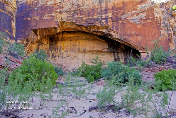
On the opposite is a alcove, it is a arch, if one stands directly in him. Sliver Arch. That told me, Lynn Session, a well-known arch-hunter.
A little further to the right is a dryfall of the Phipps Wash, which flows in its further course into the Escalante River. We follow the course of the wash to the east and pass through a narrow - aka gate.
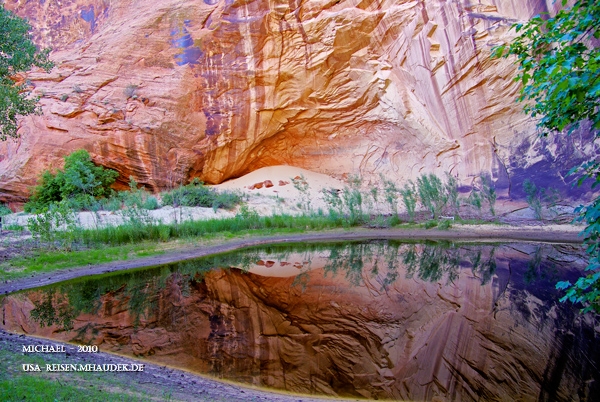
Approx. 1.9 mi later, a little side canyon is coming into the Phipps Wash. We decide, to look around the closer. Few minutes later we stand in front of a huge pool. Fed by a large dryfall - very photogenic.
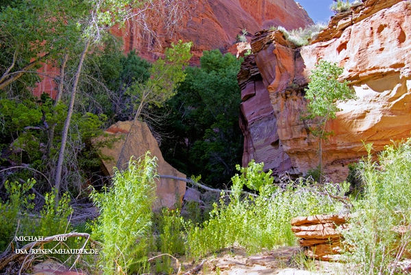
We walk back into the wash and towards the Phipps Arch. The canyon is becoming greener and narrow. A lush growth of trees, grasses and shrubs adorns the left and right side of the path. We pass a stone step and a big Boulder.
The canyon becomes wider. A little later the next side canyon comes from the east.
On his northwestern canyon wall, N37°45'18.19", W111°24'44.04", is the path, partially visible and marked by cairns. We scramble up, in glorious sunshine, up to a small plateau, whose most prominent point is a knob w/ a alcove inside.
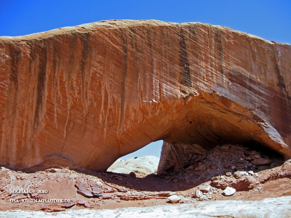
Southeast of the knob the Phipps Arch is to see. He's not huge, but beautiful. The whole dimension of the arch can only noticed correct, if you stand under the arch.
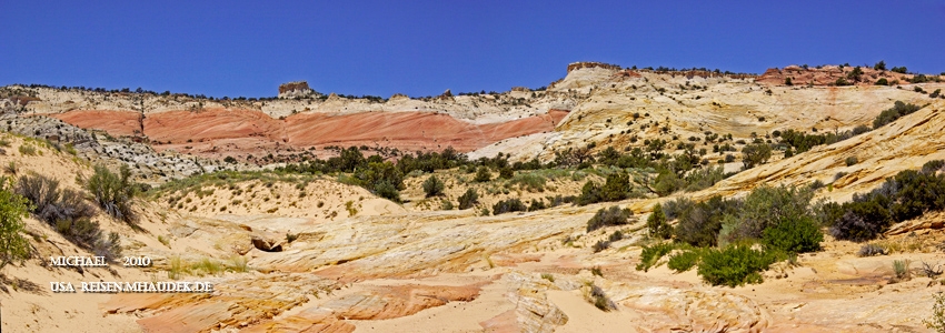
It is very scenic and beautiful on this sandstone plateau and remarkable what the nature has designed here again. After an extensive investigation of the area we go way back.
Arrived at the gate, a sweat-inducing climb is needed, to manage a height difference of about 650 ft.
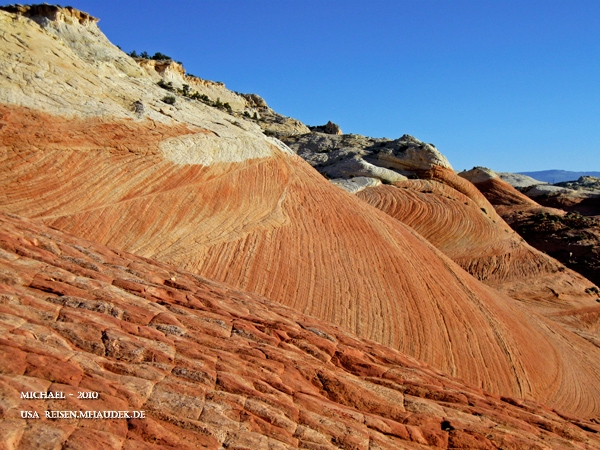
The sandstone shines in wonderful yellow and red nuances, and unfortunately not comes to its best advantage, by the glaring sunlight. We reach the rim, and walk back via Old Sheffield Road to the RV. Ice cold drinks in the fridge awaits us. After a refreshing drink we drive to the parking lot at the Big Horn Canyon, where will begin tomorrow our hike. In the evening we enjoy the sunset, overlooking the Big Spencer Flats and finish off the day at the RV.
Conclusion:
An interesting and varied hike with steep climbs and descents, off the beaten path in a beautiful countryside with interesting formations and colors.
Highlights: Phipps Arch and sandstone formations and colors in the area of descent - highly recommended (IMO).
Have fun!
_Michael
More pics, if you like.
Featured image for home page:

Phipps Arch is located in a small but beautiful Escalante Canyon, near the Spencer-Flat-Road - aka Old-Sheffield-Road. Multicolor sandstone formations, Dryfalls, Hoodoos, and an impressive arch expect the hiker on this beautiful trail in one green Canyon.
Location:
Grand Staircase Escalante National Monument (GSENM), UT 12 - Old-Sheffield-Road, Escalante, UT.
Direction:
From the west: From the center of Escalante follow the Scenic Byway 12 (Escalante, UT - Boulder, UT) approx. 10.7 mi. At N37°44'35.04", W111°26'52.73" make a right turn into the Old-Sheffield-Road. Follow that road approx. 0.4 mi. You reach the entry of a small dirt road. Make a left turn. After a couple of yards you have reached a small parking lot, N37°44'12.40", W111°26'33.68". That's the trailhead too of this hike.
In good conditions, you may be able to drive a regular passenger car, or an RV on this road.
For the current road and weather conditions, please contact the Escalante Interagency Visitor Center.
Description:
From TH, we walk up the road to the East Rim to give us an overview to find a descent point - the view is amazing. A little later, along the rim at GPS: N37°44'2.6", W111°26'22.5" we find a suitable point for us. A landmark in the area is a cube like, single rock, N37°44'1.2", W111°26'35.3". This rock is a good marker especially for the way back to the TH.
The trail leads very steeply across slickrock downward, into the Phipps Wash.
On the opposite is a alcove, it is a arch, if one stands directly in him. Sliver Arch. That told me, Lynn Session, a well-known arch-hunter.
A little further to the right is a dryfall of the Phipps Wash, which flows in its further course into the Escalante River. We follow the course of the wash to the east and pass through a narrow - aka gate.
Approx. 1.9 mi later, a little side canyon is coming into the Phipps Wash. We decide, to look around the closer. Few minutes later we stand in front of a huge pool. Fed by a large dryfall - very photogenic.
We walk back into the wash and towards the Phipps Arch. The canyon is becoming greener and narrow. A lush growth of trees, grasses and shrubs adorns the left and right side of the path. We pass a stone step and a big Boulder.
The canyon becomes wider. A little later the next side canyon comes from the east.
On his northwestern canyon wall, N37°45'18.19", W111°24'44.04", is the path, partially visible and marked by cairns. We scramble up, in glorious sunshine, up to a small plateau, whose most prominent point is a knob w/ a alcove inside.
Southeast of the knob the Phipps Arch is to see. He's not huge, but beautiful. The whole dimension of the arch can only noticed correct, if you stand under the arch.
It is very scenic and beautiful on this sandstone plateau and remarkable what the nature has designed here again. After an extensive investigation of the area we go way back.
Arrived at the gate, a sweat-inducing climb is needed, to manage a height difference of about 650 ft.
The sandstone shines in wonderful yellow and red nuances, and unfortunately not comes to its best advantage, by the glaring sunlight. We reach the rim, and walk back via Old Sheffield Road to the RV. Ice cold drinks in the fridge awaits us. After a refreshing drink we drive to the parking lot at the Big Horn Canyon, where will begin tomorrow our hike. In the evening we enjoy the sunset, overlooking the Big Spencer Flats and finish off the day at the RV.
Conclusion:
An interesting and varied hike with steep climbs and descents, off the beaten path in a beautiful countryside with interesting formations and colors.
Highlights: Phipps Arch and sandstone formations and colors in the area of descent - highly recommended (IMO).
Have fun!
_Michael
More pics, if you like.
Featured image for home page:
")
 I'll try it again another time, hopefully dropping into Phipps Wash via the side-canyon where Maverick Bridge is. Nice TR and photos, Michael!