Hiked the Paria Canyon this week(supposed to do four days but did it in three because, well, stupidity and the wife was having a breakdown while I was gone and cutting a day off was cheaper than payong for therapy).
Original plan was to camp at Big Springs Day one, then Wrather Canyon Day 2, About 3-4 miles past Last Reliable Springs to make a short hike out through the sun-exposed hone through Mordor to reach Lees Ferry. Ended up at Last Reliable Spring on Day 2 then completed it on Day 3.
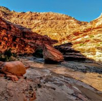
Paria River was around 19.7 Cfs and looked like the chocolate Yahoo drink. Cool morning to start off (upper 50's) with a friend and his 12 year old son, who rolled his ankle 2 miles in. Some minor mud up to the Confluence with Buckskin, where we met two hikers who weregetting through it and said the water was deep( guy was about 6'1" and he said it was up to his chest)and very cold, if anyobe is going there soon. Decent water was coming out of Buckskin allowing some filtering for water if one needed it. Beautifully colored walls, green trees and assorted shrubbery all blended well with the muddy stream.
Day two we made decent time and here is where we concocted the silly plan of doing it in three days. Wasnt long after that that I got a message from the wife on my Inreach that cemented that thought into action, and we were off to the races. We got a good rest at "The Hole" which had very little water but a very cold breeze and walls to lean on was a welcome break. Got to Wrather Canyon and the son stayed put watching the Condors catch the thermals while his dad and I made the trek to see the arch. The last part up to the arch was steeper than expected but I turned into "angry-hiker" mode and followed the Bighorn droppings until I had a good view of the arch and it was massive. Got under it and the scale of its hugeness was more readily apparent. If you go through Paria Canyon, make sure you go see it up close.
I wanted to check out Kelseys infamous "Indian Route" to the North and South Rim near Wrather, but time was of the essence so I didn't try them out, but got a decent look at the bottom of the North Rim hike and considered it "doable." Next was the Adams Trail and it looked ok, except the part of climbing up the steep sand dune would wear one out, probably like climbing the dune in Coyote Gulch.
Got to Kelseys newest "4th Crack" route(which was before Wrather) and the 15 meter downclimb crux. I went up it and it was a little airy, but not too bad. Pictures make it look steeper than it really was, but still it was about a 70 degree angle. My short-legged , fat, tired body was able to climb it so you experienced in-shape people should have no problem. It was worse bushwhacking to it than climbing it. I thought I saw another route to the East about 40 yards that looked easier to climb, buy didn't try it.
Shower Spring was a godsend. The cool pool of water leading up to it was refreshing to dip in. We tanked up with water and decided to rest for a few hours and let the sun get down over the rim, but some naked curmudgeon camping there told us we needed to leave as it was his area. After playing with the idea of tying him to a Cottonwood, we moved a short distance away and rested until we made a dash to Last Reliable. We came across several decent springs on the right side of The River that were not marked, including one unmarked spring gushing with water coming out of a small canyon.
The last 13 miles was tough. I carried 1 1/2 gallons of water and once out of the rocky trail area an ontothe "high water " route, the path was fine but it was friggin hot. Got to Wilson Ranch but the seep there was more if a smallbog that was not drinkable no matter what. We hiked from shade-to-shade and rested and drank up. I thought we had cone to where the trail register was supposed to be but it wasn't there. I got pissed and "angry-hiked" looking for it until stopping by some stone ruins to get some shade and cool down. My friend went ahead and found the register about a quarter mile away. I drank my last water and we got on the way. Got to Lonely Dell Ranch hoping for some water but the pump we saw was off. We noticed the orchard had fruit and found a couple trees with ripe nectarines so we helped ourselves to a few and trudged on. We then came to a detour as the road was closed due to construction. We asked a worker if we could slip through and thankfully he agreed to let us through. He let us get some water out of his ice-chest which was greatly appreciated. Finally we got to the road and my friend walked to the parking area to get his car while I waitedwith his son. He came backed and whime we were loading, a Park Ranger told us we couldn't park there and had to move. We told him we were just loading the car and he had no mercy, just kept saying we had to move. I was able to load everything while my friend engaged in counter-talk to buy time and finally whenthe Ranger was about to get his ticket book out, we were in the car and leaving.
I would have loved to spent 4 days to do some side-exploring instead of rushing through. May be I'll go back and try Kelseys North Rim indian route or his 4th Crack route.
As an aside, I was wondering if a drone could deliver a pizza while we were at Last Reliable Springs.


Original plan was to camp at Big Springs Day one, then Wrather Canyon Day 2, About 3-4 miles past Last Reliable Springs to make a short hike out through the sun-exposed hone through Mordor to reach Lees Ferry. Ended up at Last Reliable Spring on Day 2 then completed it on Day 3.
Paria River was around 19.7 Cfs and looked like the chocolate Yahoo drink. Cool morning to start off (upper 50's) with a friend and his 12 year old son, who rolled his ankle 2 miles in. Some minor mud up to the Confluence with Buckskin, where we met two hikers who weregetting through it and said the water was deep( guy was about 6'1" and he said it was up to his chest)and very cold, if anyobe is going there soon. Decent water was coming out of Buckskin allowing some filtering for water if one needed it. Beautifully colored walls, green trees and assorted shrubbery all blended well with the muddy stream.
Day two we made decent time and here is where we concocted the silly plan of doing it in three days. Wasnt long after that that I got a message from the wife on my Inreach that cemented that thought into action, and we were off to the races. We got a good rest at "The Hole" which had very little water but a very cold breeze and walls to lean on was a welcome break. Got to Wrather Canyon and the son stayed put watching the Condors catch the thermals while his dad and I made the trek to see the arch. The last part up to the arch was steeper than expected but I turned into "angry-hiker" mode and followed the Bighorn droppings until I had a good view of the arch and it was massive. Got under it and the scale of its hugeness was more readily apparent. If you go through Paria Canyon, make sure you go see it up close.
I wanted to check out Kelseys infamous "Indian Route" to the North and South Rim near Wrather, but time was of the essence so I didn't try them out, but got a decent look at the bottom of the North Rim hike and considered it "doable." Next was the Adams Trail and it looked ok, except the part of climbing up the steep sand dune would wear one out, probably like climbing the dune in Coyote Gulch.
Got to Kelseys newest "4th Crack" route(which was before Wrather) and the 15 meter downclimb crux. I went up it and it was a little airy, but not too bad. Pictures make it look steeper than it really was, but still it was about a 70 degree angle. My short-legged , fat, tired body was able to climb it so you experienced in-shape people should have no problem. It was worse bushwhacking to it than climbing it. I thought I saw another route to the East about 40 yards that looked easier to climb, buy didn't try it.
Shower Spring was a godsend. The cool pool of water leading up to it was refreshing to dip in. We tanked up with water and decided to rest for a few hours and let the sun get down over the rim, but some naked curmudgeon camping there told us we needed to leave as it was his area. After playing with the idea of tying him to a Cottonwood, we moved a short distance away and rested until we made a dash to Last Reliable. We came across several decent springs on the right side of The River that were not marked, including one unmarked spring gushing with water coming out of a small canyon.
The last 13 miles was tough. I carried 1 1/2 gallons of water and once out of the rocky trail area an ontothe "high water " route, the path was fine but it was friggin hot. Got to Wilson Ranch but the seep there was more if a smallbog that was not drinkable no matter what. We hiked from shade-to-shade and rested and drank up. I thought we had cone to where the trail register was supposed to be but it wasn't there. I got pissed and "angry-hiked" looking for it until stopping by some stone ruins to get some shade and cool down. My friend went ahead and found the register about a quarter mile away. I drank my last water and we got on the way. Got to Lonely Dell Ranch hoping for some water but the pump we saw was off. We noticed the orchard had fruit and found a couple trees with ripe nectarines so we helped ourselves to a few and trudged on. We then came to a detour as the road was closed due to construction. We asked a worker if we could slip through and thankfully he agreed to let us through. He let us get some water out of his ice-chest which was greatly appreciated. Finally we got to the road and my friend walked to the parking area to get his car while I waitedwith his son. He came backed and whime we were loading, a Park Ranger told us we couldn't park there and had to move. We told him we were just loading the car and he had no mercy, just kept saying we had to move. I was able to load everything while my friend engaged in counter-talk to buy time and finally whenthe Ranger was about to get his ticket book out, we were in the car and leaving.
I would have loved to spent 4 days to do some side-exploring instead of rushing through. May be I'll go back and try Kelseys North Rim indian route or his 4th Crack route.
As an aside, I was wondering if a drone could deliver a pizza while we were at Last Reliable Springs.