fossana
Member
- Joined
- Jan 11, 2018
- Messages
- 1,035
")
Background
Knowing that I was heading out to the Sierra at the end of June, on a whim I decided to look for last minute backpacking permits for the 4th of July weekend. Earlier in the COVID-19 pandemic Inyo NF had moved their permits to all online reservations, and I was able to grab the last available Bishop Pass permit.
I've been climbing in the Palisades for over two decades, but with the exception of two overnighters in college (before I discovered my capacity to do mega day trips), every visit to the region had been part of a climbing day trip. I deliberated over routes, but chose to stay in the high alpine zone, rather than looping back through the forest (and crowds) of LeConte Canyon on the JMT. Instead, I opted to go mostly x-country and loop back on the other side of the Palisades. I had never been over Scimitar Pass, or to the region between Mt Sill and Middle Palisade, and had heard good things from friends about Elinore Lake. The only uncertainty was how best to get back from the N Fork of Big Pine Creek drainage (serviced by the Big Pine Creek trailhead) to the South Lake trailhead without a shuttle. My original plan was to take the chute that links up Seventh Lake with Thunder and Lightning Lake. I packed enough food for 2 nights/3 days just in case.
Approximate Route
Mileage: 24+ miles (~50% off-trail)
Elevation gain: ~11,300 feet
Passes: Bishop Pass (11,972 feet), Thunderbolt Pass (12,400 feet) , Scimitar Pass (~13,200 feet), Contact Pass (~11,800 feet), Sky Haven ridge (~12,550 feet), "Hunchback Pass" (~11,800 feet)
View it on Caltopo


Trip Report
I left the trailhead ~7:00 am. I was feeling more acclimatized than on the Evolution hike the prior weekend, and surprised myself with a brisk pace up Bishop Pass. Sadly, that wouldn't last in the x-country zone. I left the trail just over Bishop Pass, crossed Dusy Basin, and headed for Thunderbolt Pass (the most direct route). In retrospect, Knapsack Pass would likely have been more pleasant with an overnight pack.


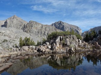
Both sides of Thunderbolt Pass were slow going with the big talus and required some 4th class downclimbing to get through the large ramps. I stopped by the shores of the 11,523' lake for a snack and to filter water.


")
I left the lake and wove my way up the ramps and across small streams to Potluck Pass, taking in the views of the towering Palisades above me.


As I approached Potluck Pass the drainages afforded sweeping views of the Black Divide peaks to the west. I contemplated camping at the 11,676' lake below Potluck Pass, but decided I'd rather push over the next pass to increase my chances of hiking out the next day.


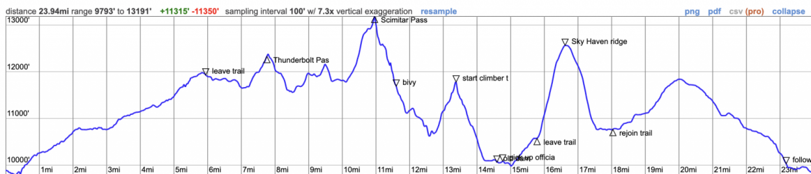
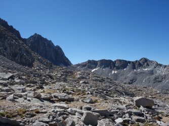
Potluck Pass is a downer in that it leaves, not from the saddle between Mt Jepson and Palisade Crest, but at ~13,200', a few hundred feet below the summit of Palisade Crest. On the E side the route drops down a sweeping ridge just N of Norman Clyde Glacier. The relatively stable talus on the W side transitions to loose moraine sand and scree on the E. I carefully picked my way down Scimitar Pass, skirting the steepening ridge to the right. The info I had suggested to stay on the right, then aim for a notch in the ridge below to cross over to the left side of the ridge and down to Elinore. I was anxious to leave the moraine, so opted to downclimb a somewhat sketchy gully to the left instead of scree skiing down. At this point it was getting close to dark, so I looked for a bivy site instead of pushing on to Elinore Lake. I downclimbed next to a waterfall and found a small sandy ledge just big enough for my tent with a stream a few hundred feet away. Arguably I had a better view from my impromptu site than I would have had from Elinore Lake.
")


In the morning I was rewarded with sweeping views of the waterfall and Norman Clyde Glacier bathed in alpine morning light. I packed up my site, filtered water, and headed toward Elinore Lake. In retrospect, it probably would have been better to stay high after descending the Scimitar Pass rib and travel closer to the edge of the moraine at the base of the peaks, but I had wanted to check out the area around Elinore lake.


I stopped at Elinore Lake to top off my water, and attempted to scope out the most direct route to Contact Pass. Nothing seemed to obviously link up through the cliff bands. I didn't want to have to backtrack, so unfortunately, I ended up having to drop through several semi-brushy drainages. Route-finding wasn't overly challenging, but with the elevation changes and terrain it was slow going. Finally, I reached the bottom of Contact Pass. I had descended the other side of Contact Pass countless times after climbing Temple Crag, so I knew what immediately lay ahead.


I made my way to the top of Contact Pass, and paused to have a look at the chute I planned ascend across the valley. It looked steep, loose, and unpleasant-sketchy. I started assessing my plan B options:
- I could hike out to the Big Pine Creek trailhead, hitch a ride to Big Pine, and catch the Eastern Sierra Transit bus (whenever that was, potentially the next day) or call one of my Bishop friends for a ride.
- I could head out over Jigsaw Pass back to Bishop Pass, but I didn't have any info on it other knowing that the W side descent chute may not be obvious and the Inconsolables tend to be chossy on that side. I also vaguely remembered someone dying there a few years back. I later learned that the post marking the correct descent route has since disappeared.
- I could climb up and over Sky Haven Ridge (a small detour from the plan A chute), which drops into the same drainage I had originally planned. It looked like a scree slog, but at least had trees and large boulders for breaks. It would add a short hike through Baker Lake Basin, where I hadn't been before.


")
I took the climbers' trail down from Contact Pass through the annoying moraine section onto more stable ground. I chose the Second Lake dam option to cross the river. None of the climbers I spoke to beforehand knew the condition of Third Lake log jam, and I didn't want to have to reroute if it was impassible. Not surprisingly, once I hit the dam area, there were a lot of hikers. That wouldn't last long, as I only had 1 mile on the main trail before turning off toward Black Lake. I didn't see anyone climbing the long routes on Temple Crag, probably a good thing given that the dark clouds were starting to gather.
")


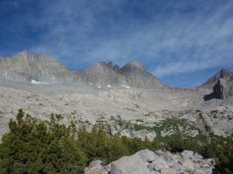
The gentler slopes of Sky Haven are guarded by dense thickets of brush, so as I ascended the trail toward Black Lake, I looked for a brush-free spot to start the climb. I found a place, and slogged up the decomposing granite slopes, attempting to walk on the boulders when possible to avoid losing ground. At least I was getting phenomenal views of the Palisades from a new-to-me perspective. As I climbed higher, the storm clouds were growing darker over the Palisades. It started to sprinkle, and I preemptively put my camera away. I heard thunder over the Palisades, and hoped to get up and over the ridgeline before it started dumping.
I made it ~a third of the way down the other side of Sky Haven when it started raining heavily. I tried to take cover under a rock overhang, but it eventually dripped water. I gave up and kept walking down the scree slope. The rain eased up soon enough, but I was drenched. I was also tired and briefly contemplated bivying in Baker Lake basin, but everything was wet and I was only ~5 miles from the trailhead, mostly on trail. I kept walking.
I beelined through the forest for the N side of the drainage, where there was a trail. Although the surrounding slopes were mostly choss piles in contrast to the craggy Palisades, the forest was lovely. Before too long, I was climbing up the final pass of the trip, an unnamed pass next to the Hunchback. The pass plateaus on a large flat alpine tundra for a ways before dropping down to Green Lake, joining the descent route for Cloudripper. I took in the solitude before descending the switchbacks into the mass of holiday backpackers around Green Lake, many of whom were ignoring the wilderness rules for camp minimum distance to water.
I passed Green and Brown Lakes, then headed down the switchbacks until I hit the old aqueduct, then walked the aqueduct back to S Lake trailhead. After 2 full days of hiking, I was ready to sleep on a real bed.


Attachments
Last edited:
