Absarokanaut
Member
- Joined
- Sep 17, 2014
- Messages
- 702
Tired of thinking and talking about the election and our future at about 7:30 PM on Friday November 11, 2016 while setting back a half dozen beers or so at the Silver Dollar Bar I frequent all too often I made the decision to try and do one of my favorite dayhikes the following morning. We'd had some heavy mountain snows a month before; but mostly warm, dry weather for more than 3 weeks gave me confidence that for the most part I would walk on top of the snow I encountered with a temp of 11 degrees starting out from US HWY 26/287 at about 9,200' just west of Togwotee Pass; about an hour and ten minutes drive Northeast from here in Jackson. I knew I might not complete the hike, but I so wanted to get up into the tundra of sheep and vole land.
My objective was the 11,040'+ Summit of Mt. Sublette; sometimes known as Brooks Lake Mt. or the Brooks Lake Cliffs. Anyone going into this area needs to know this summit is not noted on modern maps but the treacherous summit of very close by 10,537' Sublette Peak is. Sublette Peak is entirely East of the Continental Divide; here are a couple of pics of it so as to not confuse this fairly benign hike with the the far more dangerous outing of the Peak.
First, from Wind River Lake near the top of Togwotee Pass taken last Saturday:

Here it is from up on Mt. Sublette in July 2009:

Here are the Cliffs of Mt. Sublette from Wind River Lake last Saturday:

The hike begins on the North side of US HWY 26/287 about a third of a mile down from the westernmost Togwotee Pass Sign. There is a wideout there just east of a headwaters tributary of Blackrock Creek that goes under the highway. I usually do this hike as a counterclockwise loop that starts with a faint trail to the right as you descend into some willows just a couple of minutes from the highway. The trail then rises steeply through mixed conifers that have intermitently been devastated by beetles. About 1.2 miles in you cross a lovely stream with a dropping gorge that gives one of the greatest Columbine and later Monkely Flower displays you'll ever see from Later July and often into September.
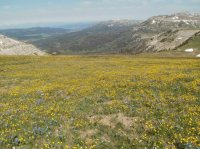
Not far after the stream crossing after rising an additional +/-250' you break into a magnificent meadow with an amazing flower display in season. After you rise up the left side of the cirque be CAREFUL unless you have wings, the cliffs on the summit and divide fall off hundreds of feet
Before doing this hike you might scout out the area. Although all but the fewest of steps are in the Bridger-Teton National Forest the best views of Mt. Sublette are in my opinion from the Shoshone National Forest's Brooks Lake area. Here, there's no hiking route up to be seen but rest assured there is a Class I route up the other Side.
Mt. Sublette is the trapezoidal highpoint here just right of Center with Sublette Peak left of Center. This entire Cliff Face is the Crest of the Continental Divide. This photo was taken from a boondocking site on the Bonneville Pass Road which begins just a mile or so short of Brooks Lake on the Brooks Lake Road; Shoshone National Firest. If you choose to drive the "4WD" Barbours Point road to Brooks Lake from Wind River Lake know that it is treacherous with just a little moisture. I've driven it many times and ended up with white kncucles a time or two so please don't do it wet.

Here is Sublette Peak on the left and Mt. Sublette from the summit of Austin Peak with the Gros Ventre Range in the background. Late July 2011:

This last Saturday I did not summit Mt. Sublette, being alone it was icy and windy enough for me to exercise better judgement. I did however get very close. It was a wonderful day and the latest I've ever been up on this section of the Divide Crest. I have posted other photos of this hike in other threads; most recently Mountains and Peaks. If folks show any interest I'll post some summer pics of this hike but for now just enjoy this Alabsater Autumn.
Sublette's summits approaching the cliffs.

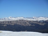
Looking at the Wind River Range. Oddly the Headwaters of the Winds are in the Southwestern Absaroka.

The Pinnacle Buttes. If I were not cautious I'd of gotten closer to the edge and you'd see Brooks Lake below:

Austin Peak:

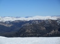
Some of the Absaroka to the Northeast:

Arguably the remotest summits of the 48 States; 12,156' Younts Peak left of Center and 12,058' Thorfare Mt. right of center in the Bridger-Teton National Forest's Teton Wilderness near the SE corner of Yellowstone National Park

More of the Absaroka with Younts Peak on the right:

Breccia Peak. Most of the rock formations of the peaks here are made up of volcanic breccia.

Mt. Moran and the wild and incredibly underated Northern Tetons to the right and the core of the Tetons in the photo below that.


From the left the Hoback Peaks of the Wyoming Range, the Snake River Range, and Southern Tetons across the Leidy Highlands. The microwave relay tower has been there a long time. Please note that tower has a massive chasm between it and Sublette's summit, not a way to go.

The Gros Ventre Range.


Another shot of Sublette's 800' plus East Face.

Can't get enough of the Wind Rivers either:

More of the Pinnacles with Black Mt. in the distance.

Sheep Mt., the backside of the Sleeping Indian in the Gros Ventre Range:

I went up over the snow in the center of these photos:


From the Continental Divide Crest I usually walk the southern boundary of the Teton Wilderness along the Breccia Divide and then down another tributary of Black Rock Creek but there was more snow than I expected. Perhaps I'll add some warmer weather pics later. It was a gorgeous day and a wonderful failure. Every failure sans injury here is joyous; otherwise I wouldn't keep going back.
Although relatively close to Jackson since the Forest Service took these trails off the map relatively few folks go up here. I've summited Sublette more than 50 times and seen another group up there once. This is not my favorite hike, but it is up there and the gateway to my favorite area on earth, the true Headwaters of the Wind River in the world's first National Forest. Thanks for coming along.
My objective was the 11,040'+ Summit of Mt. Sublette; sometimes known as Brooks Lake Mt. or the Brooks Lake Cliffs. Anyone going into this area needs to know this summit is not noted on modern maps but the treacherous summit of very close by 10,537' Sublette Peak is. Sublette Peak is entirely East of the Continental Divide; here are a couple of pics of it so as to not confuse this fairly benign hike with the the far more dangerous outing of the Peak.
First, from Wind River Lake near the top of Togwotee Pass taken last Saturday:
Here it is from up on Mt. Sublette in July 2009:
Here are the Cliffs of Mt. Sublette from Wind River Lake last Saturday:
The hike begins on the North side of US HWY 26/287 about a third of a mile down from the westernmost Togwotee Pass Sign. There is a wideout there just east of a headwaters tributary of Blackrock Creek that goes under the highway. I usually do this hike as a counterclockwise loop that starts with a faint trail to the right as you descend into some willows just a couple of minutes from the highway. The trail then rises steeply through mixed conifers that have intermitently been devastated by beetles. About 1.2 miles in you cross a lovely stream with a dropping gorge that gives one of the greatest Columbine and later Monkely Flower displays you'll ever see from Later July and often into September.
Not far after the stream crossing after rising an additional +/-250' you break into a magnificent meadow with an amazing flower display in season. After you rise up the left side of the cirque be CAREFUL unless you have wings, the cliffs on the summit and divide fall off hundreds of feet
Before doing this hike you might scout out the area. Although all but the fewest of steps are in the Bridger-Teton National Forest the best views of Mt. Sublette are in my opinion from the Shoshone National Forest's Brooks Lake area. Here, there's no hiking route up to be seen but rest assured there is a Class I route up the other Side.
Mt. Sublette is the trapezoidal highpoint here just right of Center with Sublette Peak left of Center. This entire Cliff Face is the Crest of the Continental Divide. This photo was taken from a boondocking site on the Bonneville Pass Road which begins just a mile or so short of Brooks Lake on the Brooks Lake Road; Shoshone National Firest. If you choose to drive the "4WD" Barbours Point road to Brooks Lake from Wind River Lake know that it is treacherous with just a little moisture. I've driven it many times and ended up with white kncucles a time or two so please don't do it wet.
Here is Sublette Peak on the left and Mt. Sublette from the summit of Austin Peak with the Gros Ventre Range in the background. Late July 2011:
This last Saturday I did not summit Mt. Sublette, being alone it was icy and windy enough for me to exercise better judgement. I did however get very close. It was a wonderful day and the latest I've ever been up on this section of the Divide Crest. I have posted other photos of this hike in other threads; most recently Mountains and Peaks. If folks show any interest I'll post some summer pics of this hike but for now just enjoy this Alabsater Autumn.
Sublette's summits approaching the cliffs.
Looking at the Wind River Range. Oddly the Headwaters of the Winds are in the Southwestern Absaroka.
The Pinnacle Buttes. If I were not cautious I'd of gotten closer to the edge and you'd see Brooks Lake below:
Austin Peak:
Some of the Absaroka to the Northeast:
Arguably the remotest summits of the 48 States; 12,156' Younts Peak left of Center and 12,058' Thorfare Mt. right of center in the Bridger-Teton National Forest's Teton Wilderness near the SE corner of Yellowstone National Park
More of the Absaroka with Younts Peak on the right:
Breccia Peak. Most of the rock formations of the peaks here are made up of volcanic breccia.
Mt. Moran and the wild and incredibly underated Northern Tetons to the right and the core of the Tetons in the photo below that.
From the left the Hoback Peaks of the Wyoming Range, the Snake River Range, and Southern Tetons across the Leidy Highlands. The microwave relay tower has been there a long time. Please note that tower has a massive chasm between it and Sublette's summit, not a way to go.
The Gros Ventre Range.
Another shot of Sublette's 800' plus East Face.
Can't get enough of the Wind Rivers either:
More of the Pinnacles with Black Mt. in the distance.
Sheep Mt., the backside of the Sleeping Indian in the Gros Ventre Range:
I went up over the snow in the center of these photos:
From the Continental Divide Crest I usually walk the southern boundary of the Teton Wilderness along the Breccia Divide and then down another tributary of Black Rock Creek but there was more snow than I expected. Perhaps I'll add some warmer weather pics later. It was a gorgeous day and a wonderful failure. Every failure sans injury here is joyous; otherwise I wouldn't keep going back.
Although relatively close to Jackson since the Forest Service took these trails off the map relatively few folks go up here. I've summited Sublette more than 50 times and seen another group up there once. This is not my favorite hike, but it is up there and the gateway to my favorite area on earth, the true Headwaters of the Wind River in the world's first National Forest. Thanks for coming along.
Attachments
Last edited by a moderator: