Old Sheffield/Spencer Flats Road

powderglut

In search of Fresh
Joined
Oct 17, 2012
Messages
367
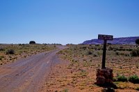
I'm wondering how familiar people are at accessing places off these roads? I'll be back in Escalante this fall for a week visit. What I have in mind is hiking to the Cosmic Navel and Upper Red Breaks from the closest area I can park on the Old Sheffield rd. Not the drill site. I noticed there was a sign saying no vehicles past the intersection point. I guess this is the parking spot? Has anyone gone in from this direction? Also.. thought I might check out Spencer Canyon, since it is right there. Anyone been to that one?
I know Michael (the Alien) did a trip to Phipps Arch off this road, any other outstanding features to access of either road, including all the way to the drill site? Appreciate any info.
 
Bighorn Canyon is a nice hike that heads off to the south from Old Sheffield.

http://backcountrypost.com/forum/threads/hole-in-the-rock-and-bighorn-canyon-escalante.454/
http://alavigne.net/Outdoors/TripReports/2006/Escalante/?p=bighorn

Now I am in no way suggesting breaking a law if the road is indeed closed, but from the placement of the sign and the heavy use of the road when I was there. It seems like that sign should say something more like 'deep sand ahead, proceed at your own risk'. Just looks well used, and if it's truly closed, why not put the sign in the middle of the road and actually CLOSE the road? I'd be curious to hear what the story is on that from someone with the BLM.
Thanks Nick. You always have something. Bighorn looks quite interesting. Especially the colored slickrock. Has possibilities for a good non technical day hike from the top.
I did see some tire tracks heading past the closed road sign this spring. Wondered about that. Do people park further up that road? Legal? Illegal?? For a hike...Thought I'd contour over to the Navel from that area and then back over towards Spencer Canyon for a look. Looks like it has great possibilities. Then back up to the car.
 
That hike down Bighorn from the top looks awesome. The route Andrew took in that other link looks particularly fun.

There's also an area NE of the road that looks cool. I forget what it's called but I've heard about it. Something about streets. Anyone know?

Here:

View Larger Map
 
Seems like it would be a much shorter to hike from the Harris Wash side.
 
That route is 6+. If I was doing it again I would park here (37°39'44.02"N 111°19'41.72"W) just before the big sand traps start and it would be under 4 miles round trip.

Just my .02
 
That canyon is called "center and main," full beta is in Kelsey's second technical canyoneering book. Also known as simply "spencer"
 
Is the road closure at the Harris Wash trailhead no longer in place?

We saw traffic on the north side of Harris in February and in April and there was no sign of the road being closed near the trailhead. Heres the map of our Big West Fork / Cano loop hike in February. We returned via the road to the south and it had tracks the entire way to the cano but the first two after leaving the canon was very VERY sandy. The closer we got to the point I marked above (37°39'44.02"N 111°19'41.72"W) the road looked more and more traveled.

http://goo.gl/maps/VDwAC

So far I'm liking the top route to include Spencer after the Navel.
Cool cool, just chiming in.
 
I sure wish that old road would be open. It was solidly blocked off when I was there in 2008. I wonder what the reasoning was for closing it to begin with.
 
I sure wish that old road would be open. It was solidly blocked off when I was there in 2008. I wonder what the reasoning was for closing it to begin with.


You should call and see if its open because it sure looks open.
Again, its sand nightmare beyond that point. No way I would drive it unless it was frozen and I think FourisTheNewOne agreed, even with his taco.
 
I sure wish that old road would be open. It was solidly blocked off when I was there in 2008. I wonder what the reasoning was for closing it to begin with.

your wish came true.

i'm quite positive garfield county was in on this lawsuit. filed in 2011, IIRC.

call garfield county public works to verify road status.


Judge rules largely in favor of Utah on rural roads dispute

Courts • Kane County and state hail ruling by federal judge in long-running dispute.

By Brooke Adams
The Salt Lake Tribune
Published: March 22, 2013 08:46AM
Updated: March 25, 2013 09:07AM
A federal judge handed a landmark victory to Kane County and the state of Utah on Wednesday in a years-long dispute with the federal government over whether some rural routes should remain in use as roads, or if they should be closed to the public.

In two decisions, U.S. District Judge Clark Waddoups found he had jurisdiction to hear Kane County’s claim, gave parameters for “reasonable” right-of-way widths on some routes and determined that 12 of 15 routes in dispute were roads and therefore accessible by the public.

The distinction hinged on an 1866 law through which Congress sought to encourage development by allowing local jurisdictions to manage routes across public lands; the law was repealed in 1976 by Revised Statute 2477.

With the revision, Congress retained most remaining public lands and created the Bureau of Land Management. Pre-existing claims, however, were grandfathered in and considered valid as long as entities moved to claim them within a 12-year time frame. Waddoups determined that Kane County did so.

Kane County Commission Chairman Doug Heaton said Thursday the ruling vindicates the county in its fight to continue to travel what he described as historic thoroughfares.

“We’re confident the judge took great pains to get it right,” he said. “We’re excited the court has ruled in our favor.”

Utah Gov. Gary Herbert and Attorney General John Swallow also hailed the decision, which Swallow said shows “these historic public roads have and will continue to belong to the people of Utah.”

Swallow said the federal government’s refusal to recognize the routes as state and county roads had “damaged the economy and put motorists at risk” by impeding routine maintenance.

Melodie Rydalch, spokeswoman for the U.S. Attorney’s Office, said the office was reviewing the decision and would not have further comment.

Heaton said the roads in question were in use for at least 10 years before 1976, and in some cases date back to the late 1800s. Kane County is made up of 65 percent federal land, Heaton said. “In order to access the public resources on these lands, you have to travel these roads.”

The legal battle was a “significant burden” financially, he said. “This is a tremendous vindication. We are simply reasserting the public’s rights to travel these roads.”

Of the 12 routes deemed roads, four are in the Grand Staircase-Escalante National Monument. The rest are on land managed by the Bureau of Land Management’s Kanab office. Waddoups traveled all of the disputed routes with attorneys in the case over two days in December 2010. He presided over a trial in the case in August 2011 and took additional testimony in January 2012.

Waddoups heard from county workers and local residents about how each route was used prior to 1976 and then how most were maintained later by the county.

Waddoups noted, for example, that Upper Mill Creek was used prior to 1976 for “the apparent purposes of gathering firewood, cutting cedar posts, hunting and scouting for deer, gathering pine nuts, and general sightseeing.”

One Kane County rancher recounted local lore of how John D. Lee cut timber and operated a saw mill in the area in the late 1800s, which led to the route’s name. Similar uses were declared for most of the other disputed routes.

The state and 22 of Utah’s 29 counties have filed more than 20 lawsuits laying claim to more than 12,000 rights-of-way on public land.

“This tsunami of litigation threatens several national parks and monuments as well as iconic Utah wilderness landscapes,” said Steve Bloch, litigation director for the Southern Utah Wilderness Alliance in an email. SUWA had filed an amicus brief in the case that focused primarily on whether Kane County asserted its claims in a timely manner.

An appeal of the decision is likely, said David Garbett, SUWA attorney.

Garbett said Utah and the counties were relying on RS 2477 to claim “dirt trails, cow paths and roads to nowhere as highways.”

“While undoubtedly some of these claims do encompass well-used and traveled and vital roads, those are roads no one is fighting over,” Garbett said, but others are indistinct paths and meandering washes in critical wilderness quality lands.

The fight, he said, could complicate wilderness designations if cow paths are determined to be roads. “It’s largely about land control and wilderness,” Garbett said.

brooke@sltrib.com

Christopher Smart contributed to this story.

http://www.sltrib.com/sltrib/news/56043106-78/roads-county-kane-public.html.csp
 
I've also heard mention of Drill Hole slot. Can anyone confirm this being just west of Red Breaks. Not much info on this one.
 
Yes, drill hole slot starts near the drill hole and zigzags sw to harris wash. I have not done it yet but was informed that there are a few rather spicy down climbs or possible short raps. I have been wanting to check it out for quite awhile after noticing it on satellite. I believe that it might be possible to bypass the raps. If/when i find out more i will let you know
 
Yes, drill hole slot starts near the drill bole and zigzags sw to harris wash. I have not done it yet but was informed that there are a few rather spicy down limbs or possible short raps. I have been wanting to check it out for quite awhile after noticing it on satellite. I believe that it might be possible to bypass the raps. If i find out more i will let you know
Thanks , I appreciate any beta on hikes and access of this road.
 
@powderglut,
I hiked in April the whole Spencer Flats Rd. west of Phipps TH down to the Dome.
The road was in a perfect condition, Red Breaks Rd too.
You can park here. There is a small lot. I saw a car and camp straight ahead on that place.

OSRd.jpg

I hiked the northern route cross-country to the west of the Dome.
Setup my camp near 06015 (on Map).
Was a lot of work w/ 50# backpack.

I also hiked twice the whole Big Horn Loop from Spencer Flat Rd. - couple of years ago.
Many nice features are along that road.
 
That hike down Bighorn from the top looks awesome. The route Andrew took in that other link looks particularly fun.

There's also an area NE of the road that looks cool. I forget what it's called but I've heard about it. Something about streets. Anyone know?

Here:

View Larger Map

it's called First & Main by BOSS & other locals. Kelsey calls it Spencer Canyon.
 
Similar threads
Thread starter Title Forum Replies Date
Writhdar Old Sheffield/Spencer Flats Road end (wellhead) questions Hiking & Camping 4
SeanIsADesertRat Old guys backpacking in Dark Canyon Backpacking 17
D Backpacking Ideas for an 8 year old Trip Planning 16
Bob Old magazine Isssues General Discussion 2
balzaccom Getting old.... General Discussion 2
T Old guy Noobs: Introduce yourself! 4
Cait Hell's Kitchen Basin - Old Pack Trail post Box Fire Trip Reports 3
McKee80 Shenandoah - Old Fat Guy in a Swimming Hole Backpacking 6
wsp_scott Overnight bike trip with a 7 year old Backpacking 1
Rockskipper I never thought I'd see empty boardwalks... (Old Faithful webcam) General Discussion 3
C Days of Old General Discussion 14
Bob Backpacking - Old School General Discussion 38
Stephanie B Old Woman Wash, Three Finger Petroglyphs, and Wild Horse Canyon (Backcountry Fest in the San Rafael Swell) Hiking & Camping 6
Nick Supporter Renewals with Old Payment Info Questions, Suggestions & Support 6
balzaccom following old roads Hiking & Camping 3
lyoungjcmo New old timer here from Missouri Noobs: Introduce yourself! 1
kwc Adirondack Winter Hike (old) Hiking & Camping 3
blueeyes Old buildings/Ghost Towns Photography 82
Perry Old South Skyline Trail - Ogden Canyon Trip Planning 1
Nick Ancient or just old? General Discussion 7
Ross Photo highlights from an old Utah trip Everything Else 7
Flaminghog2099 Old rag loop hike Trip Planning 5
C Looking for HCL 1901 Rock in Old Womans Wash Utah Noobs: Introduce yourself! 2
Blake Merrell 1 Year Old's Birthday Backpacking Trip Backpacking 22
Joey Upper Death Hollow and the Old Bowington Road, From Hell's Backbone down to the Escalante River Backpacking 24
uintahiker Requiem for 2015. So long old buddy. General Discussion 2
Desertrat Old Woman Wash Hiking & Camping 2
scatman The Old Faithful Loop - The Exploration of the Shoshone Creek and Firehole River Drainages Backpacking 39
gnwatts 4 old men in a couple of canoes On The Water 10
Howells Outdoors Snowshoeing the Old Sorrel Trail Hiking & Camping 11
hatchcanyon Old UT 95 Photography 3
Udink Upper Old Woman Wash Hiking & Camping 2
Nick Out with the old... General Discussion 0
MaddMoki A few shots from a winter solo odyssey above the Old Escalante Backpacking 9
Duke Scanning/digitizing old Photographs Photography 18
Udink Old Woman and Cottonwood Washes Hiking & Camping 5
Seldom Seen Anderson Little Purgatory and Old Babylon Trail Hiking & Camping 3
Nick Yellowstone: Old Faithful Area Hiking & Camping 4
Bill Album Rusty, Crusty, Old, and Abandoned Photography 104
Udink Old Woman Wash, San Rafael Reef Hiking & Camping 4
John Fowler Old Paria, October, 2011 Hiking & Camping 7
Dustin Gent Red Breaks via Spencer Creek Road General Discussion 1
Michael Phipps Arch Hike, Spencer Flat Rd. TH - 2010 Hiking & Camping 9
intuitive cat Loop Hike-Spencer Flats to just above Zebra Slot Hiking & Camping 6

Similar threads

Back
Top