- Joined
- Jan 16, 2022
- Messages
- 23
I recently returned from a backpacking trip into Dark Canyon with an old friend. We entered into the canyon via the Sundance "trail" on Sunday, Apr 3. (I use quotes around the word trail, because it's more of a route than a trail, if you ask me.) For those who aren't familiar, the Sundance "Trail" descends from the canyon rim over a large scree and boulder field for about 1400 ft, give or take. The total descent from the rim to the bottom of the Sundance took us about an hour and a half. It required frequent stops to try to determine where the best route would be, always looking out for cairns to lead the way.
After reaching the bottom of Dark Canyon proper, we hiked upstream for a brief distance and camped by some Cottonwoods. This campsite was scenic, but was full of stickers that looked like little goat head stickers. Not the sort of place you'd want to go walking around barefoot.

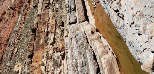
On the second day, we decided to hike up canyon to Young's Canyon, which we had heard had a nice place to camp. We packed up on Monday morning and set off, thinking that the estimated distance of 6 miles would take us 2-3 hours. Unfortunately, we had some difficulties in navigating the canyon. A few miles up from Lost Canyon, pour offs require that you get up on the ledges above the bottom of the canyon to ascend. My hiking partner decided to try the left side (looking up river), and I hiked up on the right side, following some cairns, and a somewhat decent trail. My friend encountered some rough going on the left side, and it took us quite some time to get up the canyon.

At one point, Jacques had to climb up a log, and onto the rock, then foist his pack up behind him to continue.

We were both exhausted by late afternoon, and decided to make camp instead of continuing on to Young's Canyon. I don't have pictures of the Monday night camp, but it was decent. I give it three stars.
On Tuesday, we continued up canyon and arrived at the mouth of Young's canyon after a 2 mile hike. This was a very nice camp site, and a nice place to relax and enjoy the canyon's beauty.

We explored around in the lower reaches of Young's Canyon, and were impressed with the hikers who were using that route to continue on towards the Needles District of Canyonlands, NP.
On Wednesday, we decided to hike down canyon to camp at the mouth of Lost Canyon. Since we had learned a few lessons on route finding in Dark Canyon, going back down turned out to be much easier than when we came up canyon. The total distance was about 7.75 miles, and it took about 4 hours for the two old guys to make the hike.
The camp at the mouth of Lost Canyon was quite nice, with sheltered spots in the Cottonwoods for tents.

On Thursday, we decided we would hike all the way down to the Colorado River, then back up to camp as near to the bottom of the Sundance Trail as we could. This is because the Sundance Trail faces east, and in early April the sun starts hitting the trail by around 7 - 7:30, and we really didn't want to have to haul our old selves up that thing in the hot sun.
Back to the hike from Lost Canyon to the Colorado, we decided we would just leave our backpacks near the junction to the Sundance trail, and hike out and back to the Colorado. This turned out to be a good thing, because the full day was about 11 miles, with 4000' of climbing. And, although it was nice to get all the way down to the Colorado, the bottom third of a mile of Dark Canyon was sandy/muddy and a completely different character. I think this is due to the fact that Lake Powell used to back up into the bottom of Dark Canyon, allowing silt and sediment to accumulate there. The mud and muck at the Colorado river itself was actually quite stinky. There were bubbles coming up through the mud here and there.


We returned back to the junction of Dark Canyon and the Sundance trail and camped nearby, ready for an early start on Friday.

We got up around 6 on Friday, had a quick breakfast, some coffee, and started the long hike up that hill.
Overall, this was a great trip, even for old guys.

Happy Trails!!!
After reaching the bottom of Dark Canyon proper, we hiked upstream for a brief distance and camped by some Cottonwoods. This campsite was scenic, but was full of stickers that looked like little goat head stickers. Not the sort of place you'd want to go walking around barefoot.
On the second day, we decided to hike up canyon to Young's Canyon, which we had heard had a nice place to camp. We packed up on Monday morning and set off, thinking that the estimated distance of 6 miles would take us 2-3 hours. Unfortunately, we had some difficulties in navigating the canyon. A few miles up from Lost Canyon, pour offs require that you get up on the ledges above the bottom of the canyon to ascend. My hiking partner decided to try the left side (looking up river), and I hiked up on the right side, following some cairns, and a somewhat decent trail. My friend encountered some rough going on the left side, and it took us quite some time to get up the canyon.
At one point, Jacques had to climb up a log, and onto the rock, then foist his pack up behind him to continue.
We were both exhausted by late afternoon, and decided to make camp instead of continuing on to Young's Canyon. I don't have pictures of the Monday night camp, but it was decent. I give it three stars.
On Tuesday, we continued up canyon and arrived at the mouth of Young's canyon after a 2 mile hike. This was a very nice camp site, and a nice place to relax and enjoy the canyon's beauty.
We explored around in the lower reaches of Young's Canyon, and were impressed with the hikers who were using that route to continue on towards the Needles District of Canyonlands, NP.
On Wednesday, we decided to hike down canyon to camp at the mouth of Lost Canyon. Since we had learned a few lessons on route finding in Dark Canyon, going back down turned out to be much easier than when we came up canyon. The total distance was about 7.75 miles, and it took about 4 hours for the two old guys to make the hike.
The camp at the mouth of Lost Canyon was quite nice, with sheltered spots in the Cottonwoods for tents.
On Thursday, we decided we would hike all the way down to the Colorado River, then back up to camp as near to the bottom of the Sundance Trail as we could. This is because the Sundance Trail faces east, and in early April the sun starts hitting the trail by around 7 - 7:30, and we really didn't want to have to haul our old selves up that thing in the hot sun.
Back to the hike from Lost Canyon to the Colorado, we decided we would just leave our backpacks near the junction to the Sundance trail, and hike out and back to the Colorado. This turned out to be a good thing, because the full day was about 11 miles, with 4000' of climbing. And, although it was nice to get all the way down to the Colorado, the bottom third of a mile of Dark Canyon was sandy/muddy and a completely different character. I think this is due to the fact that Lake Powell used to back up into the bottom of Dark Canyon, allowing silt and sediment to accumulate there. The mud and muck at the Colorado river itself was actually quite stinky. There were bubbles coming up through the mud here and there.
We returned back to the junction of Dark Canyon and the Sundance trail and camped nearby, ready for an early start on Friday.
We got up around 6 on Friday, had a quick breakfast, some coffee, and started the long hike up that hill.
Overall, this was a great trip, even for old guys.
Happy Trails!!!