- Joined
- Apr 20, 2013
- Messages
- 1,460
We need some more Pacific Northwest in here. I follow only in the footsteps of the few, but great reports we have had from the PNW.
For the second consecutive year, I headed to Washington. Because of needs from both jobs I had to delay the desired mid-September for the very end of September and early October. I knew the colors would be great in October, but was concerned about crowds, weather, (and lack of huckleberries ).
).
Regardless, I broke out the possible days into a schedule and asked my friend to find us a "warm-up" hike for a few days. We kicked around some stuff in the Olympics, with a potential last night on a beach, but ultimately eyed Rainier.
You probably do not recall, but last year my second trip was scuppered because of "Mt Rainier-not-appearing-in-this-trip". At that time, worn out as we were, we were uninterested in doing a trip on Rainier with no chance of seeing more of the mountain and an incoming storm.
This year, being able to get onto Rainier was very appealing.
My friend got us permits and researched the route. After my arrival in the Seattle area the night before, we gathered food and packed up before the drive to the Carbon Ranger Station.
There was a looming possibility of a government shutdown over the weekend, so we discussed that with the rangers, were told they might lock the gate behind us, but would provide either a code to the padlock or station a ranger at the gate. The explanation was good enough for us, and had also led to some cancellations in permits, so that was all fine.
The weather had turned the week leading up to our trip. There was fresh snow higher up, clearing clouds and fog, and rain expected that afternoon and night. The original forecast has said two of the three days of this trip were going to rain, but the storm shifted and really, the weather was fantastic for fall.
At home, I had three trips to pack for, so essential snacks and not-freeze-dried were all packaged and labeled with the help of my eldest daughter.

On the drive in, we saw a cow elk and calf on the road, and arrived to a mostly empty parking lot. There were a half dozen cars going up to Tolmie lookout, but only a few cars farther down.
We were going in a counter-clockwise direction, with a really short first day. When we had planned the permits we were not sure if I would arrive the night before or the day of, so we had flexibility.
The clearing fog was wonderfully photogenic and I spent a little time taking a few photos with no one around.

Fall colors, clearing mist, turquoise water, cedars and pines...

This one I shared in the panoramas.

We had a really short first day. We dropped down into the forest and made quick time to camp. We had toyed with the idea of going at-large up in Spray Park, but decided against it for simplicity's sake.

Is that you Gandalf the White?


After procuring a camping site, setting up the tent, and hanging food, we made our way to Spray Falls. The falls were a no-show... the fog was too thick, and we could not even see the start of them from the base, so we went on up the climb.
We would repeat the climb the next day, but we were aiming to just head toward Rainier on a side trail and take our time enjoying the colors and intermittent sunshine.
Mother Mountain cleared of fog.

"Big" and Little Tahoma made some appearances.

Little Tahoma

We continued on up past meadows of autumn colors, small ponds, glacial streams, noisy pikas, and on towards the mountain. After a while we paused, ate a lunch, steripened some water and hung out as the mist lapped against the mountain like waves.


I mean seriously? so nice! More colors than lupine and wildflower season up here.

Two curious onlookers, hard to say if they are black-tails or northwestern muleys?
I lean towards Muleys, based on where we were and what the black-tails looked like that we saw on Trip #2.
.jpg")
No bears... just trees, rocks, water and color.

On the way back down it had cleared enough to see the falls.

Back down to camp

The silvery light here was wonderful as the fog thickened in the trees. This is from the iphone.

The next day we packed up for our longest day. Up over Spray, down to Carbon, across the bridge and then south to Ipsut for the night.
After a little rain, the wind had come in and dried everything off and cleared the sky.
Autumn colors were everywhere. Each corner was brighter and bolder than the last. We took our time walking up to the high point of the day. I could post a hundred pictures with slightly different views and all of the colors, but here are a few too many... and not necessarily in order of when they were taken.


The backlit reds and snow were a delight. Like cherries and whipped cream on a banana split (you see, I always relate to food).

The small ponds and tarns were ice.


I kept following this guy, since he had half the food and the permit.

More of one of the Mother Mountain Peaks.

A far off sister peak to Rainier.

Some of the Mother Peaks.

Out there we could see our location for Trip #2, starting in a couple of days.


We did not see any bears, only a deer in the distance and some more pikas. Eventually we topped out, and started our descent through the snow. The mist had deposited a little layer of rime and needle ice had pushed up in areas making them slick. Watching your footing and not overstepping on the way down was key.
This mention of slippery might be a red herring or it might be foreshadowing.

After we cleared the snow. We were above Misty Park/Valley. It looked like an incredible place, as did Seattle Park as we walked through.
Nature's manicured gardens hung between cliffs and spread out before us. We descended like the cascading water, down, always down, leaving the snow and the views into Misty Park behind.
Skittles, M&Ms, rainbow tic-tacs, any number of vibrant , never ending colors- some outlawed in the state of California- spread out around every pine or cedar and every alpine slope.
It was nothing short of amazing and the smile plastered to my face was breaking off months of stress and grime.


Down we go.

Then a rock in an innocuous cascade got in the way.
It was not too wide or deep. I stepped on one gray stone and was aiming to step to another greenish stone. As I touched the green stone, I slipped and barreled forward, arms flailing and consciously falling to my right side to protect the camera on my strap. I do not know what hit first. Knees, wrist, arm, crown of my head. Everything impacted, crashed and splashed all at once.
When I felt my head hit the embankment on the side of the creek, I feared for concussion. I have had more than a few. I didn’t seem to have a concussion, and I did not stars or go unconscious. Phew!
I was kind of kneeling in the stream. I pushed up and immediately my wrist hurt. I stood in the stream, but then I couldn’t, my knee wouldn’t support the weight. I stumbled and fell down just off the trail and out of the creek.
My right knee was bruising and throbbing- a good thing. The immediate pain and stinging was because I struck my knee, not because I twisted it.
My head hurt only a little and my friend was laughing at my good fortune of hitting brush and moss instead of the protruding granite stones.
My neck hurt from twisting awkwardly as my head had hit the bank.
Luckily nothing major in what had been a step of overconfidence. I would feel the pain in my knee, especially on any descent for the rest of the trip and even today. Ibuprofen and ice-cold dips in streams and lakes helped. It could have been worse.
Ahead of us was a slippery slide of death that looked like the place I was more likely to slip on a step. I did not have to worry about it yet, but just watched the water running down the mossy stone as I recovered my whits and massaged my knee looking for tender spots. My wrist was sprained, but that was not a concern. I felt a bit sheepish that such a little step almost ended my long trip.
My friend went across while I got my breath back and then came back for my pack.
The well placed rock was a simple step. Problem was my knee screamed at beating weight, so I took on more water and gave it time.

Finally I was able to stand, cross and continue on a little gingerly for me down the trail.
It is like a slip and slide.

Rushing water was our constant companion, and soon it became a roar as trickles joined streams, joined creeks, all cascading downhill.
Miles washed away as we kept dropping altitude. We passed a group going the opposite direction. They were quite winded and not even to the worst parts of the climb.

Cute, little orange fungi grew in the mossy places.

Soon we were in the trees and for a long time we kept descending down to where the creek met the valley floor.
After checking out the falls and camp for future reference we broke out lunch. On the way back to the trail, we had a conversation with a ranger about the possibility of a shutdown.
From there we went and took some time in the sun at the suspension bridge. The ranger passed us again and then we were on our way.

More fungi.

Suspension bridge. There used to be a trail on either side of the Carbon, but one was washed out.


Looking back to where we had come from earlier that morning.

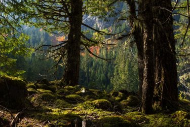
We walked a pleasant stroll on the trail under massive, moss covered cedars and by mossy green boulders. It was wonderful.
Almost like a Wonderland...

Looking back towards Carbon Glacier, the lowest elevation glacier in the lower 48 -they say... It is dark and covered with debris.

The bridge crossing back over the Carbon... although we had to cross portions of the river again and again farther down.

I really liked these tall pines in the flood plain.

Orange fungi.

The crossing of Carbon is a bit convoluted since the trail was washed out by the 2006 floods.
The final crossing is best described as a toddler playing with tinker toys. You cross several series of logs almost at random. Some logs were split, some smoothed, some not. A few are higher off the ground and I clenched on one where I had to lose momentum trying to step up on a knot with a knee that was already screaming in pain and not exactly stable.
I did not take any good pictures of that spot. It was just a final minor problem and the knee was hurting bad.
The colors continued... Carbon/Turquoise river depending on the lighting.

More autumn colors, a bit more sublime and subdued in the afternoon shade.


Ipsut Falls. We grabbed some water here and took it on with us to camp.

It did not take long after that to find a camp spot away from the five or so groups that were already there.
The ranger's cabin had been damaged by the floods. It was restored and looks good.

We wandered farther downriver, checking out the road. Biking into the camp is the fastest way up the old road. It would be an easy overnighter.
After a peaceful night and more ibuprofen, we woke up and started the steady climb up Ipsut Creek towards the pass. Not much mileage, but plenty of elevation gain.

More fungi.

This broken cedar was lighting the way.

Getting closer.

Some trip reports talked about scaring up bear along Ipsut. We had no such luck, but we did find this billy and mother goat.

Views back down from where we had started the morning. The last half mile or so on the switchbacks is steep and burns the lungs and the legs.

We cleared the pass and started to hear voices. The government had not shut down, leaving us alone.
Instead the hordes had descended on Tolmie on a Sunday afternoon.
We caught our breath, ditched our packs and headed off to the Tolmie trail. I had misread the map and thought the distance was less, and my knee hated me as we climbed around the lake and up to the fire tower. My knee and most of the rest of me, hated me even more on the descent and then the additional climb back up to the trail intersection.
Autumn colors were still prevalent and it was a wonderfully sunny day.


Rainier and some of our route were all visible.

Another peak covered in red where it had been clearcut.

The lake and more people down below.

Mother Mountain's ridge and several peaks.

Rainier trying to hide once again.

Once we were back to our packs it was time to continue with the horde and get back to our vehicle.
The lake was many brilliant colors of blue.

No clearing fog or clouds this time.

We cleaned up a little and headed back for a shower, to regroup and pack up for the five day trip starting the next morning. There was some rain inbound and early week weather to account for, followed by a clear weekend.
The loop was great. So many beautiful sights. We only saw a handful of groups on the trail, and only three people in Spray Park. We lucked out perhaps with the later season, clearing weather or threat of a shutdown because Sunday when we got back to the trailhead it was full. I think Mowich is a beautiful lake with easy access. I can understand why there are many people.
I think everything in the Cascades is steep. In the Winds or Uintas, etc, it feels like you can get high and stay relatively high, but these trails in the Cascades take you up and drop you down in all of the steep river valleys. The topography is different, whether that is geological, the amount of water, narrower mountains, or trail design. I dunno, but it adds to the challenge.
Would our luck with weather and crowds continue? dun dun dun...
Stay tuned for Trip 2. If I can get around to exporting the photos!
For the second consecutive year, I headed to Washington. Because of needs from both jobs I had to delay the desired mid-September for the very end of September and early October. I knew the colors would be great in October, but was concerned about crowds, weather, (and lack of huckleberries
).Regardless, I broke out the possible days into a schedule and asked my friend to find us a "warm-up" hike for a few days. We kicked around some stuff in the Olympics, with a potential last night on a beach, but ultimately eyed Rainier.
You probably do not recall, but last year my second trip was scuppered because of "Mt Rainier-not-appearing-in-this-trip". At that time, worn out as we were, we were uninterested in doing a trip on Rainier with no chance of seeing more of the mountain and an incoming storm.
This year, being able to get onto Rainier was very appealing.
My friend got us permits and researched the route. After my arrival in the Seattle area the night before, we gathered food and packed up before the drive to the Carbon Ranger Station.
There was a looming possibility of a government shutdown over the weekend, so we discussed that with the rangers, were told they might lock the gate behind us, but would provide either a code to the padlock or station a ranger at the gate. The explanation was good enough for us, and had also led to some cancellations in permits, so that was all fine.
The weather had turned the week leading up to our trip. There was fresh snow higher up, clearing clouds and fog, and rain expected that afternoon and night. The original forecast has said two of the three days of this trip were going to rain, but the storm shifted and really, the weather was fantastic for fall.
At home, I had three trips to pack for, so essential snacks and not-freeze-dried were all packaged and labeled with the help of my eldest daughter.
On the drive in, we saw a cow elk and calf on the road, and arrived to a mostly empty parking lot. There were a half dozen cars going up to Tolmie lookout, but only a few cars farther down.
We were going in a counter-clockwise direction, with a really short first day. When we had planned the permits we were not sure if I would arrive the night before or the day of, so we had flexibility.
The clearing fog was wonderfully photogenic and I spent a little time taking a few photos with no one around.
Fall colors, clearing mist, turquoise water, cedars and pines...
This one I shared in the panoramas.
We had a really short first day. We dropped down into the forest and made quick time to camp. We had toyed with the idea of going at-large up in Spray Park, but decided against it for simplicity's sake.
Is that you Gandalf the White?
After procuring a camping site, setting up the tent, and hanging food, we made our way to Spray Falls. The falls were a no-show... the fog was too thick, and we could not even see the start of them from the base, so we went on up the climb.
We would repeat the climb the next day, but we were aiming to just head toward Rainier on a side trail and take our time enjoying the colors and intermittent sunshine.
Mother Mountain cleared of fog.
"Big" and Little Tahoma made some appearances.
Little Tahoma
We continued on up past meadows of autumn colors, small ponds, glacial streams, noisy pikas, and on towards the mountain. After a while we paused, ate a lunch, steripened some water and hung out as the mist lapped against the mountain like waves.
I mean seriously? so nice! More colors than lupine and wildflower season up here.
Two curious onlookers, hard to say if they are black-tails or northwestern muleys?
I lean towards Muleys, based on where we were and what the black-tails looked like that we saw on Trip #2.
No bears... just trees, rocks, water and color.
On the way back down it had cleared enough to see the falls.
Back down to camp
The silvery light here was wonderful as the fog thickened in the trees. This is from the iphone.
The next day we packed up for our longest day. Up over Spray, down to Carbon, across the bridge and then south to Ipsut for the night.
After a little rain, the wind had come in and dried everything off and cleared the sky.
Autumn colors were everywhere. Each corner was brighter and bolder than the last. We took our time walking up to the high point of the day. I could post a hundred pictures with slightly different views and all of the colors, but here are a few too many... and not necessarily in order of when they were taken.
The backlit reds and snow were a delight. Like cherries and whipped cream on a banana split (you see, I always relate to food).
The small ponds and tarns were ice.
I kept following this guy, since he had half the food and the permit.
More of one of the Mother Mountain Peaks.
A far off sister peak to Rainier.
Some of the Mother Peaks.
Out there we could see our location for Trip #2, starting in a couple of days.
We did not see any bears, only a deer in the distance and some more pikas. Eventually we topped out, and started our descent through the snow. The mist had deposited a little layer of rime and needle ice had pushed up in areas making them slick. Watching your footing and not overstepping on the way down was key.
This mention of slippery might be a red herring or it might be foreshadowing.
After we cleared the snow. We were above Misty Park/Valley. It looked like an incredible place, as did Seattle Park as we walked through.
Nature's manicured gardens hung between cliffs and spread out before us. We descended like the cascading water, down, always down, leaving the snow and the views into Misty Park behind.
Skittles, M&Ms, rainbow tic-tacs, any number of vibrant , never ending colors- some outlawed in the state of California- spread out around every pine or cedar and every alpine slope.
It was nothing short of amazing and the smile plastered to my face was breaking off months of stress and grime.
Down we go.
Then a rock in an innocuous cascade got in the way.
It was not too wide or deep. I stepped on one gray stone and was aiming to step to another greenish stone. As I touched the green stone, I slipped and barreled forward, arms flailing and consciously falling to my right side to protect the camera on my strap. I do not know what hit first. Knees, wrist, arm, crown of my head. Everything impacted, crashed and splashed all at once.
When I felt my head hit the embankment on the side of the creek, I feared for concussion. I have had more than a few. I didn’t seem to have a concussion, and I did not stars or go unconscious. Phew!
I was kind of kneeling in the stream. I pushed up and immediately my wrist hurt. I stood in the stream, but then I couldn’t, my knee wouldn’t support the weight. I stumbled and fell down just off the trail and out of the creek.
My right knee was bruising and throbbing- a good thing. The immediate pain and stinging was because I struck my knee, not because I twisted it.
My head hurt only a little and my friend was laughing at my good fortune of hitting brush and moss instead of the protruding granite stones.
My neck hurt from twisting awkwardly as my head had hit the bank.
Luckily nothing major in what had been a step of overconfidence. I would feel the pain in my knee, especially on any descent for the rest of the trip and even today. Ibuprofen and ice-cold dips in streams and lakes helped. It could have been worse.
Ahead of us was a slippery slide of death that looked like the place I was more likely to slip on a step. I did not have to worry about it yet, but just watched the water running down the mossy stone as I recovered my whits and massaged my knee looking for tender spots. My wrist was sprained, but that was not a concern. I felt a bit sheepish that such a little step almost ended my long trip.
My friend went across while I got my breath back and then came back for my pack.
The well placed rock was a simple step. Problem was my knee screamed at beating weight, so I took on more water and gave it time.
Finally I was able to stand, cross and continue on a little gingerly for me down the trail.
It is like a slip and slide.
Rushing water was our constant companion, and soon it became a roar as trickles joined streams, joined creeks, all cascading downhill.
Miles washed away as we kept dropping altitude. We passed a group going the opposite direction. They were quite winded and not even to the worst parts of the climb.
Cute, little orange fungi grew in the mossy places.
Soon we were in the trees and for a long time we kept descending down to where the creek met the valley floor.
After checking out the falls and camp for future reference we broke out lunch. On the way back to the trail, we had a conversation with a ranger about the possibility of a shutdown.
From there we went and took some time in the sun at the suspension bridge. The ranger passed us again and then we were on our way.
More fungi.
Suspension bridge. There used to be a trail on either side of the Carbon, but one was washed out.
Looking back to where we had come from earlier that morning.
We walked a pleasant stroll on the trail under massive, moss covered cedars and by mossy green boulders. It was wonderful.
Almost like a Wonderland...
Looking back towards Carbon Glacier, the lowest elevation glacier in the lower 48 -they say... It is dark and covered with debris.
The bridge crossing back over the Carbon... although we had to cross portions of the river again and again farther down.
I really liked these tall pines in the flood plain.
Orange fungi.
The crossing of Carbon is a bit convoluted since the trail was washed out by the 2006 floods.
The final crossing is best described as a toddler playing with tinker toys. You cross several series of logs almost at random. Some logs were split, some smoothed, some not. A few are higher off the ground and I clenched on one where I had to lose momentum trying to step up on a knot with a knee that was already screaming in pain and not exactly stable.
I did not take any good pictures of that spot. It was just a final minor problem and the knee was hurting bad.
The colors continued... Carbon/Turquoise river depending on the lighting.
More autumn colors, a bit more sublime and subdued in the afternoon shade.
Ipsut Falls. We grabbed some water here and took it on with us to camp.
It did not take long after that to find a camp spot away from the five or so groups that were already there.
The ranger's cabin had been damaged by the floods. It was restored and looks good.
We wandered farther downriver, checking out the road. Biking into the camp is the fastest way up the old road. It would be an easy overnighter.
After a peaceful night and more ibuprofen, we woke up and started the steady climb up Ipsut Creek towards the pass. Not much mileage, but plenty of elevation gain.
More fungi.
This broken cedar was lighting the way.
Getting closer.
Some trip reports talked about scaring up bear along Ipsut. We had no such luck, but we did find this billy and mother goat.
Views back down from where we had started the morning. The last half mile or so on the switchbacks is steep and burns the lungs and the legs.
We cleared the pass and started to hear voices. The government had not shut down, leaving us alone.
Instead the hordes had descended on Tolmie on a Sunday afternoon.
We caught our breath, ditched our packs and headed off to the Tolmie trail. I had misread the map and thought the distance was less, and my knee hated me as we climbed around the lake and up to the fire tower. My knee and most of the rest of me, hated me even more on the descent and then the additional climb back up to the trail intersection.
Autumn colors were still prevalent and it was a wonderfully sunny day.
Rainier and some of our route were all visible.
Another peak covered in red where it had been clearcut.
The lake and more people down below.
Mother Mountain's ridge and several peaks.
Rainier trying to hide once again.
Once we were back to our packs it was time to continue with the horde and get back to our vehicle.
The lake was many brilliant colors of blue.
No clearing fog or clouds this time.
We cleaned up a little and headed back for a shower, to regroup and pack up for the five day trip starting the next morning. There was some rain inbound and early week weather to account for, followed by a clear weekend.
The loop was great. So many beautiful sights. We only saw a handful of groups on the trail, and only three people in Spray Park. We lucked out perhaps with the later season, clearing weather or threat of a shutdown because Sunday when we got back to the trailhead it was full. I think Mowich is a beautiful lake with easy access. I can understand why there are many people.
I think everything in the Cascades is steep. In the Winds or Uintas, etc, it feels like you can get high and stay relatively high, but these trails in the Cascades take you up and drop you down in all of the steep river valleys. The topography is different, whether that is geological, the amount of water, narrower mountains, or trail design. I dunno, but it adds to the challenge.
Would our luck with weather and crowds continue? dun dun dun...
Stay tuned for Trip 2. If I can get around to exporting the photos!