BeardoMcGrath
Member
- Joined
- Jan 31, 2022
- Messages
- 55
I've only recently graduated from lurker to commenter on here but have found the contributors very knowledgeable and friendly so I thought I'd start another and yet hopefully not redundant conditions thread for an upcoming trip to Utah in mid-May. Traditionally these trips have involved mostly car camping with longer day hikes, since I find dealing with water annoying when backpacking in the desert. This trip will be similar, with one exception (see below). In general I am expecting more water than normal in the canyons, and possibly bad bugs later in the trip due to wet winter/spring conditions (we are travelling May 7-20).
Lower Fortymile Gulch Backpack (3 days/2 nights): We did the classic Fortymile/Willow Loop in May 2020 as a dayhike and very much enjoyed it, but didn't have the time to explore farther down the canyon. There doesn't seem to be too much info on recent conditions in the lower canyon, but looking at SentinelHub it looks like the water level has retreated all the way past the end of the canyon. I have read the brush can be bad down here but our idea is to hike down Fortymile through the pools (hopefully not too deep and cold!) and camp somewhere near the N Fk confluence the first night. Then on the second day dayhike down to "Bishop Canyon" (Kelsey name) and then all the way to the head of that. Kelsey's Lake Powell guide notes there is supposed to be an amazing alcove at the head of Bishop and so if the brush and mud isn't too bad we hope to get up there. Or maybe the head of the N Fk if the brush is too bad. Has anyone been down that way recently? I saw a report from 2011 saying the tamarisk was a nightmare but I know over time in places that has been dying off? On the third day will will hike back up Willow to Sooner Bench.
Next we will be heading up to Fiftymile Bench/Mtn and car camping two nights with a trip up to the top during the day via the Lower Trail. Thanks to @Fatboy for some tips on that area. I am interested to see the condition of the Sooner Slide Rd but I suspect I can get a better conditions report in Escalante immediately prior.
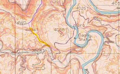
After that we are heading east to Cedar Mesa or the Abajos (depending on the snow situation). But before we get there we are considering taking the "scenic" route through Poison Springs Canyon and then across the Dirty Devil. With the big snowpack I'm somewhat hesitant to try this since the crossing may not be possible. What is a "crossable" stream flow? I know it also depends on what the approaches are like and if the road has been graded. While in the area we are considering hiking Happy Canyon Narrows but with the road from Black Jump being blocked we may end up skipping this whole area. Looking at the map one alternative would be to hike up to the old mining road from the little ridge where the Poison Spring Road crosses from the lower portion of the canyon over to the DDR. From the map and satellite this looks doable, and then I had the idea to float back down the DDR to the road crossing after visiting the narrows. Perhaps a little ambitious but a fun idea. Not sure if anyone has tried that. (see 1st map)
Optimally we will then head up to Elk Ridge in order to access Fable Valley and Beef Basin for the 2nd half of the trip. Looking at the snotel site at Camp Jackson (8858 ft) this seems pretty marginal so we will keep an eye on the conditions. Assuming it all melts out in time this is our plan:
- 2 nights on N Long Point and a full day hike into Fable Valley from the south.
- 2 nights in Beef Basin to explore the various ruins there
- Maybe one more longer day hike into upper Salt Creek on our way out.
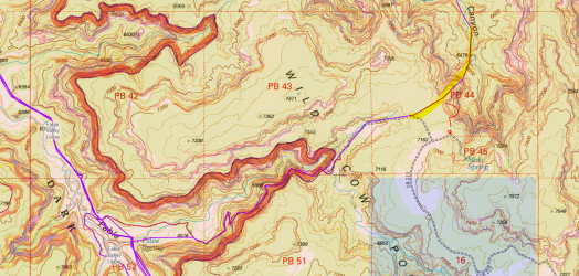
Regarding Fable Valley: Is it possible to loop from the lower Beef Basin TH through Wild Cow Canyon up onto Wild Cow Point and then back down into South Canyon? This looks like it would be fun but I have read trying to find a route on or off Wild Cow Point might not be possible. (see 2nd map)
If the roads are still snow covered/a muddy mess we will stay down around Cedar Mesa. We want to avoid dealing with permits too much so this is our itinerary:
- Upper White Canyon dayhike (NBNM)
- Grand Gulch dayhike from Collins Spring TH (hike at least as far as Deer Canyon and back)
- Slickhorn Canyon Loop (1st fk to Trail fk)
- Lewis Lodge Ruins
- Hammond Canyon via Cream Pots TH (it seems likely it will be possible to hike in from this TH even if the upper one is still snowed in).
I appreciate the great collection of knowledge on this forum and will report back after our trip!
Lower Fortymile Gulch Backpack (3 days/2 nights): We did the classic Fortymile/Willow Loop in May 2020 as a dayhike and very much enjoyed it, but didn't have the time to explore farther down the canyon. There doesn't seem to be too much info on recent conditions in the lower canyon, but looking at SentinelHub it looks like the water level has retreated all the way past the end of the canyon. I have read the brush can be bad down here but our idea is to hike down Fortymile through the pools (hopefully not too deep and cold!) and camp somewhere near the N Fk confluence the first night. Then on the second day dayhike down to "Bishop Canyon" (Kelsey name) and then all the way to the head of that. Kelsey's Lake Powell guide notes there is supposed to be an amazing alcove at the head of Bishop and so if the brush and mud isn't too bad we hope to get up there. Or maybe the head of the N Fk if the brush is too bad. Has anyone been down that way recently? I saw a report from 2011 saying the tamarisk was a nightmare but I know over time in places that has been dying off? On the third day will will hike back up Willow to Sooner Bench.
Next we will be heading up to Fiftymile Bench/Mtn and car camping two nights with a trip up to the top during the day via the Lower Trail. Thanks to @Fatboy for some tips on that area. I am interested to see the condition of the Sooner Slide Rd but I suspect I can get a better conditions report in Escalante immediately prior.
After that we are heading east to Cedar Mesa or the Abajos (depending on the snow situation). But before we get there we are considering taking the "scenic" route through Poison Springs Canyon and then across the Dirty Devil. With the big snowpack I'm somewhat hesitant to try this since the crossing may not be possible. What is a "crossable" stream flow? I know it also depends on what the approaches are like and if the road has been graded. While in the area we are considering hiking Happy Canyon Narrows but with the road from Black Jump being blocked we may end up skipping this whole area. Looking at the map one alternative would be to hike up to the old mining road from the little ridge where the Poison Spring Road crosses from the lower portion of the canyon over to the DDR. From the map and satellite this looks doable, and then I had the idea to float back down the DDR to the road crossing after visiting the narrows. Perhaps a little ambitious but a fun idea. Not sure if anyone has tried that. (see 1st map)
Optimally we will then head up to Elk Ridge in order to access Fable Valley and Beef Basin for the 2nd half of the trip. Looking at the snotel site at Camp Jackson (8858 ft) this seems pretty marginal so we will keep an eye on the conditions. Assuming it all melts out in time this is our plan:
- 2 nights on N Long Point and a full day hike into Fable Valley from the south.
- 2 nights in Beef Basin to explore the various ruins there
- Maybe one more longer day hike into upper Salt Creek on our way out.
Regarding Fable Valley: Is it possible to loop from the lower Beef Basin TH through Wild Cow Canyon up onto Wild Cow Point and then back down into South Canyon? This looks like it would be fun but I have read trying to find a route on or off Wild Cow Point might not be possible. (see 2nd map)
If the roads are still snow covered/a muddy mess we will stay down around Cedar Mesa. We want to avoid dealing with permits too much so this is our itinerary:
- Upper White Canyon dayhike (NBNM)
- Grand Gulch dayhike from Collins Spring TH (hike at least as far as Deer Canyon and back)
- Slickhorn Canyon Loop (1st fk to Trail fk)
- Lewis Lodge Ruins
- Hammond Canyon via Cream Pots TH (it seems likely it will be possible to hike in from this TH even if the upper one is still snowed in).
I appreciate the great collection of knowledge on this forum and will report back after our trip!