DrNed
The mountains are calling and I must go
- Joined
- Mar 31, 2013
- Messages
- 1,026
Due to the sensitive nature of this story, I hope I can report on this trip with
the kindness and thoughtfulness that it deserves.
Without a clear explanation of why, I am fascinated by the stories of those who disappear
or die in the wilderness.
In this case, the story of Kim & Carole, my fascination was exponentially higher because of
the great writing by @Dave in his Special Feature - The Mystery of Kim and Carole.
Also, so much evidence was left behind it is possible to make some explanation of their
actions and maybe even understand their choices.
I have a daughter who just returned from serving as an LDS missionary in Mexico and
her younger sister who was just about to do the same in Wichita, Kansas. With three
months to work with we came up with one night in mid August where all three of us could get together for a backpacking trip.
With only a one night trip possible Clyde Lake sounded like the perfect destination.
With work and responsibilities we didn't get to the Crystal Lake TH until 3:30 PM. It was a ZOO!
We ended up having to park over a mile away, past Washington Lake and walk back.
It was so packed that people made spots where there really weren't any.

It was even worse Saturday evening when we got back to the TH.
We started out on the trail towards Long Lake and there was a sign warning of a fire somewhere in the direction we were going.
It was such governmental, red tape, kind of writing I didn't understand a word of it . . .
and everybody else was heading down the trail so we did too.
Along the trail there is a small sign directing you towards Cliff Lake - this was the turn off
we needed.

Here we're passing Lilly Lake (I think) on our way to Cliff Lake.

We got to Cliff Lake and I thought, "Why isn't there anybody camping here?" This is a great little lake, and only about 2 miles from the TH. As much craziness as there was at the trail head, once we left the Long Lake trail we hadn't seen anybody.

It wasn't until we arrived at Clyde Lake, did I divulge all of intentions for this trip. This is from the south west side of Clyde Lake looking towards the Notch.

With my admission my daughters questioned what all was on the agenda. I explained and they skeptically agreed.
To this point we have only seen two fisherman back at Watson Lake. Unfortunately, things were about to change.
The trail takes a hiker along the west side of Clyde Lake. We attempted to find a camp spot off the trail here, but the geography didn't allow for it. So we wandered over the ridge towards Three Divides Lake and while it wasn't as packed as the parking lot there were A LOT of people here. We did find a nice meadow on the north east corner of Three Divides and decided to make it home.

Once we had camp set up we started our research.
The following was the most influential discovery for me.
From the photographic evidence found it is known that Kim & Carole stood here and took a
similar photo. Their photo showed that it was raining.

From my image you can see there is a little walk down to the lake, which is where I'd guess they took their photo.
From this exact spot I rotated 90 degree to the south, my right, and took this image.

Had they continued on the Clyde Lake Loop, and it appears to me that's what they were doing, this is the way they would have gone.
The reason that I believe this is so significant is that I believe it shows that their decision to go west was a choice to leave the trail.
Unless someone has evidence showing that the trail in 2003 was not as clearly marked, it is nearly impossible to believe that they went west because they had lost the trail.
I find it interesting that while their photographs show it was raining, they decided to leave the trail here.
There is not another photograph until they get to Hidden Lake so the specific spot of where they turned west is unknown. Assuming it was at spot in the above image I started heading west and followed the path of least resistance.
The path of least resistance took me through the meadow I was camped in on the north east side and then along the south side of the western two portions of Three Divides.
To gain some perspective, once we got west of Three Divides we started climbing Mt Watson. About 1/3 of the way up geography stopped us. Here's Three Divides.

Then, turning a little more to the west you see Hidden Lake. The most western portion of Three Divides is just out of sight to the right of this image.

After this we called it a night and headed back to camp.
The next morning we were up and determined to again follow the path of least resistance to Hidden Lake and then south towards the spot they ended up.
Once we got west of Three Divides the growth wasn't particularly dense.


Then, just before reaching Hidden Lake the trees get thicker.

Once Kim & Carole left Three Divides they have to know Hidden Lake is out there. From the spot where I'm assuming they left the trail, it's only 10-20 yards and you see Three Divides.
Once you leave Three Divides there's nothing to suggest there's anything else to see. Why do they keep going west from Three Divides? They must know Hidden lake is out there. This suggests that they are still making informed decisions.
Here we are at Hidden Lake.

From this spot we moved forward along this shore of the lake. It's at the western end of Hidden Lake that there is a little thumb off the main part of the lake, where it appears Kim & Carole took their Hidden Lake photo.
From there we moved south and found the meadow they took the shot of Carole in front of the stream shot. I didn't put a lot of effort into finding the exact location, but I was certain that we were in the right meadow. To this point I've followed the path of least resistance and ended up close to where they did.
Actually, heading west along Hidden Lake there isn't much of a trail. Assuming they ended up somewhere along this shore line when they reached Hidden Lake, why did they keep going? There's nothing else to see. There's no apparent reason to keep going they way they did.
I would have turned back towards Three Divides here.
I just can't believe they were lost here. Since leaving Clyde Lake they've generally walked in one direction next to MT Watson.
If I assume leaving the Clyde Lake Loop Trail was an informed decision to see the other lakes, it has to be here at Hidden Lake that they decide they're going to try and circle Mt Watson. There's no other reason to head south from Hidden Lake the way they did.
If one can accept the above conclusions, I find their Meadow Photo even more interesting because it would suggest that attempting to circle Watson wasn't made under stress.
Which makes that choice even harder for me to understand.
From the meadow, I changed my plan. Instead of following the path of least resistance I decided to take the most direct route towards their resting spot. My mistake.
The geography was steep and the growth moderately dense, making travel difficult and slow.
It was during this stretch my daughters protested against our route and what we were attempting to find.
So we decided to accept the fact we learned some things about their choices and head back.

We got back to camp, rested and then broke camp and headed back to the car. Some decided it was okay to park in the middle of the road.

A selfie on the walk to the car.

We then stopped for dinner and shakes at Granny's in Heber. This has always been a favorite spot, but it wasn't as good this time.

It was a great to spend some uninterrupted time with my girls.
Standing in the places Kim and Carole did my heart aches for what they suffered.
I feel as though I've gained some understanding of their experience, but I can't quite put it into words, so I'm not going to try.
the kindness and thoughtfulness that it deserves.
Without a clear explanation of why, I am fascinated by the stories of those who disappear
or die in the wilderness.
In this case, the story of Kim & Carole, my fascination was exponentially higher because of
the great writing by @Dave in his Special Feature - The Mystery of Kim and Carole.
Also, so much evidence was left behind it is possible to make some explanation of their
actions and maybe even understand their choices.
I have a daughter who just returned from serving as an LDS missionary in Mexico and
her younger sister who was just about to do the same in Wichita, Kansas. With three
months to work with we came up with one night in mid August where all three of us could get together for a backpacking trip.
With only a one night trip possible Clyde Lake sounded like the perfect destination.
With work and responsibilities we didn't get to the Crystal Lake TH until 3:30 PM. It was a ZOO!
We ended up having to park over a mile away, past Washington Lake and walk back.
It was so packed that people made spots where there really weren't any.
It was even worse Saturday evening when we got back to the TH.
We started out on the trail towards Long Lake and there was a sign warning of a fire somewhere in the direction we were going.
It was such governmental, red tape, kind of writing I didn't understand a word of it . . .
and everybody else was heading down the trail so we did too.
Along the trail there is a small sign directing you towards Cliff Lake - this was the turn off
we needed.
Here we're passing Lilly Lake (I think) on our way to Cliff Lake.
We got to Cliff Lake and I thought, "Why isn't there anybody camping here?" This is a great little lake, and only about 2 miles from the TH. As much craziness as there was at the trail head, once we left the Long Lake trail we hadn't seen anybody.
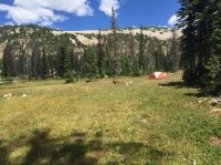
It wasn't until we arrived at Clyde Lake, did I divulge all of intentions for this trip. This is from the south west side of Clyde Lake looking towards the Notch.
With my admission my daughters questioned what all was on the agenda. I explained and they skeptically agreed.
To this point we have only seen two fisherman back at Watson Lake. Unfortunately, things were about to change.
The trail takes a hiker along the west side of Clyde Lake. We attempted to find a camp spot off the trail here, but the geography didn't allow for it. So we wandered over the ridge towards Three Divides Lake and while it wasn't as packed as the parking lot there were A LOT of people here. We did find a nice meadow on the north east corner of Three Divides and decided to make it home.
Once we had camp set up we started our research.
The following was the most influential discovery for me.
From the photographic evidence found it is known that Kim & Carole stood here and took a
similar photo. Their photo showed that it was raining.
From my image you can see there is a little walk down to the lake, which is where I'd guess they took their photo.
From this exact spot I rotated 90 degree to the south, my right, and took this image.
Had they continued on the Clyde Lake Loop, and it appears to me that's what they were doing, this is the way they would have gone.
The reason that I believe this is so significant is that I believe it shows that their decision to go west was a choice to leave the trail.
Unless someone has evidence showing that the trail in 2003 was not as clearly marked, it is nearly impossible to believe that they went west because they had lost the trail.
I find it interesting that while their photographs show it was raining, they decided to leave the trail here.
There is not another photograph until they get to Hidden Lake so the specific spot of where they turned west is unknown. Assuming it was at spot in the above image I started heading west and followed the path of least resistance.
The path of least resistance took me through the meadow I was camped in on the north east side and then along the south side of the western two portions of Three Divides.
To gain some perspective, once we got west of Three Divides we started climbing Mt Watson. About 1/3 of the way up geography stopped us. Here's Three Divides.
Then, turning a little more to the west you see Hidden Lake. The most western portion of Three Divides is just out of sight to the right of this image.
After this we called it a night and headed back to camp.
The next morning we were up and determined to again follow the path of least resistance to Hidden Lake and then south towards the spot they ended up.
Once we got west of Three Divides the growth wasn't particularly dense.
Then, just before reaching Hidden Lake the trees get thicker.
Once Kim & Carole left Three Divides they have to know Hidden Lake is out there. From the spot where I'm assuming they left the trail, it's only 10-20 yards and you see Three Divides.
Once you leave Three Divides there's nothing to suggest there's anything else to see. Why do they keep going west from Three Divides? They must know Hidden lake is out there. This suggests that they are still making informed decisions.
Here we are at Hidden Lake.
From this spot we moved forward along this shore of the lake. It's at the western end of Hidden Lake that there is a little thumb off the main part of the lake, where it appears Kim & Carole took their Hidden Lake photo.
From there we moved south and found the meadow they took the shot of Carole in front of the stream shot. I didn't put a lot of effort into finding the exact location, but I was certain that we were in the right meadow. To this point I've followed the path of least resistance and ended up close to where they did.
Actually, heading west along Hidden Lake there isn't much of a trail. Assuming they ended up somewhere along this shore line when they reached Hidden Lake, why did they keep going? There's nothing else to see. There's no apparent reason to keep going they way they did.
I would have turned back towards Three Divides here.
I just can't believe they were lost here. Since leaving Clyde Lake they've generally walked in one direction next to MT Watson.
If I assume leaving the Clyde Lake Loop Trail was an informed decision to see the other lakes, it has to be here at Hidden Lake that they decide they're going to try and circle Mt Watson. There's no other reason to head south from Hidden Lake the way they did.
If one can accept the above conclusions, I find their Meadow Photo even more interesting because it would suggest that attempting to circle Watson wasn't made under stress.
Which makes that choice even harder for me to understand.
From the meadow, I changed my plan. Instead of following the path of least resistance I decided to take the most direct route towards their resting spot. My mistake.
The geography was steep and the growth moderately dense, making travel difficult and slow.
It was during this stretch my daughters protested against our route and what we were attempting to find.
So we decided to accept the fact we learned some things about their choices and head back.
We got back to camp, rested and then broke camp and headed back to the car. Some decided it was okay to park in the middle of the road.
A selfie on the walk to the car.
We then stopped for dinner and shakes at Granny's in Heber. This has always been a favorite spot, but it wasn't as good this time.
It was a great to spend some uninterrupted time with my girls.
Standing in the places Kim and Carole did my heart aches for what they suffered.
I feel as though I've gained some understanding of their experience, but I can't quite put it into words, so I'm not going to try.
Attachments
Last edited:


