- Joined
- Mar 11, 2022
- Messages
- 47
Hello everyone,
Below are photos from a beautiful loop hike I completed a few weeks ago in the Indian Peaks Wilderness. From the Mitchell Creek Trailhead, the route follows the Mt Audubon trail to its end at the summit of Mt. Audubon. From there, the route scrambles cross country along the beautiful class 3 ridge connecting Mt Audubon and Paiute Peak, over the summit of Paiute Peak, then south along the Continental Divide making its way down to Blue Lake, southeast of Paiute Peak. From there you can pick up the Mitchell and Blue Lakes trail which will take you back to the Mitchell Creek trailhead and your car. The entire loop is about 9 miles long and can be completed in a long day - there is a decent write up and map in Roach's 'Colorado Indian Peaks' guide.
Most of the class 3 sections along the ridge crest can be avoided by staying on the class 2 talus on the south side of the ridge. However the most aesthetic line, with the most solid rock, is most often found on the ridge crest. If you're comfortable with class 3 climbing, I highly recommend it. Also, the summit of the lesser visited Paiute peak, right on the continental divide, is truely spectacular. It alone is worth the effort of this route.
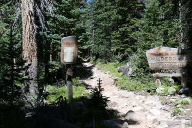 Start of the Mt Audubon trail, near the Mitchell creek parking area.
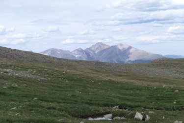 Beautiful views of the Longs Peak group, from the east slopes of Mt. Audubon. From left to right you see Chiefs Head Peak, Pagoda Mountain, Longs Peak, and Mt. Meeker.
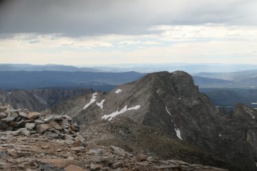 From the summit of Mt. Audubon, view of the route over to Paiute Peak. Consider the weather carefully before launching. Especially after reaching the Audubon/Paiute saddle, there is no easy escape off of the ridge. The class 2 descent off of Paiute Peak follows the left skyline ridge to a talus gully just on the other side of that ridge.
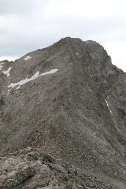
From near the Audubon/paiute saddle, close up of the rest of the route up to Paiute Peak. The ridge steepens and narrows on the way to Pauite's summit - the feeling here is distinctly alpine with airy views of Coney lakes to the north and Blue lakes to the south. There are very few obstacles to contend with on the ridge crest, allowing for smooth continuous scrambling. One obstacle is a 15 ft cliff about half way up the ridge - you can bypass this by climbing along the base of this cliff on the south side via some steep class 2 moves. Above the cliff band, as you approach the summit, the ridge crest becomes fractured and difficult to climb. The best line follows some class2/3 slabs immediately left of the ridge crest which lead to the summit.
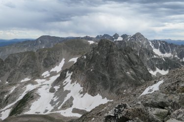
A spectacular view, looking south along the Continental Divide from Paiute Peak's summit. Mt. Toll, with its 5.6 north ridge/face is in the foreground. Beyond that you can see Apache Peak, Navahoe Peak, and the Arapahoes.
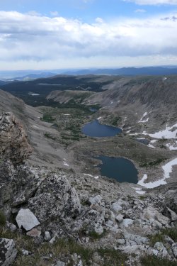
Upper and lower Blue Lakes, from the summit of Paiute. Some class 3 cliffs barr a direct descent to upper Blue Lake from the vantage point in this picture. From the summit, you have to head down Paiute's south ridge (right on the continental divide) towards Mt. Toll. Where the south ridge makes a sharp turn to the west, you'll find a class 2 talus gully that leads to upper Blue lake. In late July, there was a snowfield in the upper part of the gully that I was able to bypass on the left side - earlier in the season I suspect you would need an ice axe to safely descend this gully. From the right (south) shore of upper blue lake in the picture, I descended south down a wide talus field and picked up a cairned route leading to the north shoreline of lower blue lake. About half way along the north shorline of the lower lake, I picked up the Mitchell and Blue lakes trail, which took me back to the Mitchell Creek parking area This trail is very popular and was easy to follow with a headlamp, if needed. Happy trails!
Below are photos from a beautiful loop hike I completed a few weeks ago in the Indian Peaks Wilderness. From the Mitchell Creek Trailhead, the route follows the Mt Audubon trail to its end at the summit of Mt. Audubon. From there, the route scrambles cross country along the beautiful class 3 ridge connecting Mt Audubon and Paiute Peak, over the summit of Paiute Peak, then south along the Continental Divide making its way down to Blue Lake, southeast of Paiute Peak. From there you can pick up the Mitchell and Blue Lakes trail which will take you back to the Mitchell Creek trailhead and your car. The entire loop is about 9 miles long and can be completed in a long day - there is a decent write up and map in Roach's 'Colorado Indian Peaks' guide.
Most of the class 3 sections along the ridge crest can be avoided by staying on the class 2 talus on the south side of the ridge. However the most aesthetic line, with the most solid rock, is most often found on the ridge crest. If you're comfortable with class 3 climbing, I highly recommend it. Also, the summit of the lesser visited Paiute peak, right on the continental divide, is truely spectacular. It alone is worth the effort of this route.
 Start of the Mt Audubon trail, near the Mitchell creek parking area.
 Beautiful views of the Longs Peak group, from the east slopes of Mt. Audubon. From left to right you see Chiefs Head Peak, Pagoda Mountain, Longs Peak, and Mt. Meeker.
 From the summit of Mt. Audubon, view of the route over to Paiute Peak. Consider the weather carefully before launching. Especially after reaching the Audubon/Paiute saddle, there is no easy escape off of the ridge. The class 2 descent off of Paiute Peak follows the left skyline ridge to a talus gully just on the other side of that ridge.
From near the Audubon/paiute saddle, close up of the rest of the route up to Paiute Peak. The ridge steepens and narrows on the way to Pauite's summit - the feeling here is distinctly alpine with airy views of Coney lakes to the north and Blue lakes to the south. There are very few obstacles to contend with on the ridge crest, allowing for smooth continuous scrambling. One obstacle is a 15 ft cliff about half way up the ridge - you can bypass this by climbing along the base of this cliff on the south side via some steep class 2 moves. Above the cliff band, as you approach the summit, the ridge crest becomes fractured and difficult to climb. The best line follows some class2/3 slabs immediately left of the ridge crest which lead to the summit.

A spectacular view, looking south along the Continental Divide from Paiute Peak's summit. Mt. Toll, with its 5.6 north ridge/face is in the foreground. Beyond that you can see Apache Peak, Navahoe Peak, and the Arapahoes.

Upper and lower Blue Lakes, from the summit of Paiute. Some class 3 cliffs barr a direct descent to upper Blue Lake from the vantage point in this picture. From the summit, you have to head down Paiute's south ridge (right on the continental divide) towards Mt. Toll. Where the south ridge makes a sharp turn to the west, you'll find a class 2 talus gully that leads to upper Blue lake. In late July, there was a snowfield in the upper part of the gully that I was able to bypass on the left side - earlier in the season I suspect you would need an ice axe to safely descend this gully. From the right (south) shore of upper blue lake in the picture, I descended south down a wide talus field and picked up a cairned route leading to the north shoreline of lower blue lake. About half way along the north shorline of the lower lake, I picked up the Mitchell and Blue lakes trail, which took me back to the Mitchell Creek parking area This trail is very popular and was easy to follow with a headlamp, if needed. Happy trails!
