- Joined
- May 5, 2012
- Messages
- 1,732
Never been much of a peak bagger, but I've spent so much time staring up at Mount Watson over the years that it started to bother. Too much looking up puts a crick in the neck. I wanted to look down, to see the splay of the land from above.

Peak bag hikes never seem like much fun to me, though. They're all grind and heavy breathing, with little time to enjoy the view. Still, ideas can feel like slivers trapped under the skin. The irritation gets worse each time you rub against it.
The only way to relieve the pain was to get on top of that giant pile of rocks.
At 11,521 feet above sea level, Mount Watson isn't the highest peak in the range or even the immediate region (nearby Bald Mountain is 11,943). But it stands alone, unconnected to any other peak. And it rises above one of the most scenic spots in the Uintas: the place where the Provo and Weber River headwaters split. Lakes surround it on three sides. The fourth side falls into the gorge of the Middle Fork Weber River.
Most accounts I've read of people summiting have them doing so along the northeast ridge. They start working up the slope near Clyde Lake, gaining the ridge near a prominent outcrop. From there, they follow the ridge to the summit. From the Crystal Lake Trailhead, it's an ascent of about 1,500 feet.
My plan was a bit different. I intended to pick a route up along the south ridge. It's a shorter approach and, as a bonus, off trail. That means solitude and a more wilderness experience. Unfortunately, it meant little in the way of published accounts revealed by a quick Google search.

But eyes on the prize are often more valuable that someone else's account, anyhow.. In this shot from a hike in late 2017, you can see the south ridge. There are some cliff bands to be avoided on the right.

Here's another, closer view of the route from today.

The plan was simple, then. Go up, following the most stable path that avoided cliff bands or slopes too steep to scramble.
I departed the Lakes Country trail on the back side of Crystal Lake and started working my way across alternating meadows and cliff bands toward the foot of the mountain. Wildflowers were in full effect.

On the topo map, I aimed for the flat-ish knob at the south side of the mountain indicated by the 10,600 contour line. When I hit that spot, a cold wind blasted me from the southwest. It would continue doing so for the entirety of the ascent. Not fun.
Route finding wasn't too bad. There were a few places where I had to avoid some steep scree. The section between the 11,200 and 11,400 contour lines seemed to last forever. Above 11,400, the slope flattens out and I stopped worrying about a boulder crushing my ankle (as I was alone).

In this next shot, you can see the northeast ridge falling away toward Clyde Lake. The route down follows the ridge to the knob about halfway down, then drops off the east side of the ridge to avoid some cliffy bits.

Looking back on the way I had come provided nice perspective on Trial and Washington Lakes. Crystal Lake and the trailhead are obscured by the ridgeline.

Long Mountain came into view to the west as well.

The Notch looks different from up here.

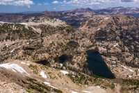
Let's play a game. It's called 'name the lakes.'

The wind at the summit didn't let up much. I decided that returning by way of the south ridge didn't sound much fun if it meant being buffeted by 30 mile-per-hour wind gusts. I decided to descend the northeast ridge. This came with some anxiety though, as I wasn't sure if the patchy snow would interfere. Thankfully, I only had to cross one snowfield.
The northeast ridge offered some great views into the area around Hidden Lake. I've walked through this meadow before, but it looks so much better from above.

Once past that point, it was a simple stair-step down to Clyde.
Here's the view looking back up at the last half of the northeast ridge route.

After so long, it's nice to finally have gone to the top. Doing this summit as a loop made it all the more enjoyable. I'm not sure I'd have enjoyed it as well if the descent were down the south ridge.

Peak bag hikes never seem like much fun to me, though. They're all grind and heavy breathing, with little time to enjoy the view. Still, ideas can feel like slivers trapped under the skin. The irritation gets worse each time you rub against it.
The only way to relieve the pain was to get on top of that giant pile of rocks.
At 11,521 feet above sea level, Mount Watson isn't the highest peak in the range or even the immediate region (nearby Bald Mountain is 11,943). But it stands alone, unconnected to any other peak. And it rises above one of the most scenic spots in the Uintas: the place where the Provo and Weber River headwaters split. Lakes surround it on three sides. The fourth side falls into the gorge of the Middle Fork Weber River.
Most accounts I've read of people summiting have them doing so along the northeast ridge. They start working up the slope near Clyde Lake, gaining the ridge near a prominent outcrop. From there, they follow the ridge to the summit. From the Crystal Lake Trailhead, it's an ascent of about 1,500 feet.
My plan was a bit different. I intended to pick a route up along the south ridge. It's a shorter approach and, as a bonus, off trail. That means solitude and a more wilderness experience. Unfortunately, it meant little in the way of published accounts revealed by a quick Google search.
But eyes on the prize are often more valuable that someone else's account, anyhow.. In this shot from a hike in late 2017, you can see the south ridge. There are some cliff bands to be avoided on the right.
Here's another, closer view of the route from today.
The plan was simple, then. Go up, following the most stable path that avoided cliff bands or slopes too steep to scramble.
I departed the Lakes Country trail on the back side of Crystal Lake and started working my way across alternating meadows and cliff bands toward the foot of the mountain. Wildflowers were in full effect.
On the topo map, I aimed for the flat-ish knob at the south side of the mountain indicated by the 10,600 contour line. When I hit that spot, a cold wind blasted me from the southwest. It would continue doing so for the entirety of the ascent. Not fun.
Route finding wasn't too bad. There were a few places where I had to avoid some steep scree. The section between the 11,200 and 11,400 contour lines seemed to last forever. Above 11,400, the slope flattens out and I stopped worrying about a boulder crushing my ankle (as I was alone).
In this next shot, you can see the northeast ridge falling away toward Clyde Lake. The route down follows the ridge to the knob about halfway down, then drops off the east side of the ridge to avoid some cliffy bits.
Looking back on the way I had come provided nice perspective on Trial and Washington Lakes. Crystal Lake and the trailhead are obscured by the ridgeline.
Long Mountain came into view to the west as well.
The Notch looks different from up here.
Let's play a game. It's called 'name the lakes.'
The wind at the summit didn't let up much. I decided that returning by way of the south ridge didn't sound much fun if it meant being buffeted by 30 mile-per-hour wind gusts. I decided to descend the northeast ridge. This came with some anxiety though, as I wasn't sure if the patchy snow would interfere. Thankfully, I only had to cross one snowfield.
The northeast ridge offered some great views into the area around Hidden Lake. I've walked through this meadow before, but it looks so much better from above.
Once past that point, it was a simple stair-step down to Clyde.
Here's the view looking back up at the last half of the northeast ridge route.
After so long, it's nice to finally have gone to the top. Doing this summit as a loop made it all the more enjoyable. I'm not sure I'd have enjoyed it as well if the descent were down the south ridge.
")
