- Joined
- Dec 23, 2013
- Messages
- 4,118
Alright, this one is for you @Jackson. ") I've posted a couple of reports of my hikes up Mount Olympus in the past, But this is the first time that I have hiked to the top in the winter, so I guess that warrants another write-up.
I've posted a couple of reports of my hikes up Mount Olympus in the past, But this is the first time that I have hiked to the top in the winter, so I guess that warrants another write-up.
My daughter, Katie was crazy enough to join me and we hit the trail about 8:15 in the morning. It soon became apparent that we had too many layers on and by the time we reached the Mount Olympus Wilderness sign we had had enough and took some of our layers off. Once we reached Tolecat Canyon, we stopped for a short break to rest up for Suicide Hill and beyond.
Once we left the stream in Tolecat, we started to encounter some snow and ice on the trail. At this point though, we didn't need our micro-spikes. Once we reached the top of Suicide Hill and curved around into the next canyon, we soon encountered enough snow that we had to put on our spikes and we wore them all the way to the top of the mountain.
The stretch between Suicide Hill and the saddle is always the toughest for me and this time was no exception though hiking on the snow I found to be easier than continually stepping up on rock after rock that you find when the trail is snow free.
We finally reached the saddle and took another quick break before heading up the last 600 feet to the top. This last segment usually has some scrambling associated with it and one small section was rather tricky for us due to the ice and snow making things a little slippery. After this section, it was pretty straight forward the rest of the way.
Once on top, we enjoyed a great view and some lunch. The wind had been blowing all day and had cleared out the valley, and from the top you could see forever. We had the top of the Mountain to ourselves while we ate our lunch and after about 45 minutes, we started back down. Heading down was a little trickier than going up, especially just off the top where I slipped and slid quite a ways down before catching myself. Other than that, the hike down was fairly uneventful. When we got back to the trailhead, we headed to the Porcupine to celebrate with some nachos.

Goofball at the trailhead

Katie, making her way up the stairs at the beginning of the hike. I really hate these stairs, both going up and coming down!

Katie, at the wilderness sign

Trail is in good condition

A glimpse of where we are heading

Heading through some scrub oak

Juniper full of berries

Stream in Tolecat Canyon - it usually dries up by summers end

Katie enjoying a quick rest in Tolecat Canyon

No comment

My day pack with all the essentials

Katie hiking up Suicide Hill, hitting the first snow/ice on the trail

Just beyond this point we stopped to put on our micro-spikes

We there yet?

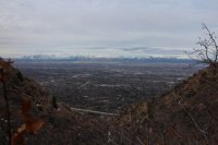
Katie, with Salt Lake Valley in the background


First view of the west ridge

Almost to the saddle

Triangle Peak

A look along the Wasatch with clouds over Lone Peak - viewed from the saddle

This is the last 600 feet to the top - viewed from the saddle

heading up the draw

Katie, with Broads Fork Twin Peaks and cloud covered Lone Peak in the distance

Katie, making her final push to the top

Almost to the summit

The north summit of Mount Olympus which we both hiked up back in November. It is a tougher slog than hiking up the south summit

Twin Peaks to the south

Closer look at Twin Peaks

Cloud covered Lone Peak to the south

Grandeur Peak to the north

Deseret Peak to the west in sunlight beyond the Oquirrh Mountains

Our lunch pad

Katie, taking her time coming down just off the top. I slipped where she is and slid down to where I took this shot.

Another shot of Twin Peaks with a touch of blue sky

More blue sky but clouds still engulf Lone Peak

Trail sign - quite a few people actually get lost on there way down from Olympus. This sign was erected to keep people on the right course.

A view of Suicide Hill on our way down

Katie with a nice view of where we had hiked in the background

Don't know why, but I liked this shot. A juniper trying to survive among all the scrub oak.
I've posted a couple of reports of my hikes up Mount Olympus in the past, But this is the first time that I have hiked to the top in the winter, so I guess that warrants another write-up.My daughter, Katie was crazy enough to join me and we hit the trail about 8:15 in the morning. It soon became apparent that we had too many layers on and by the time we reached the Mount Olympus Wilderness sign we had had enough and took some of our layers off. Once we reached Tolecat Canyon, we stopped for a short break to rest up for Suicide Hill and beyond.
Once we left the stream in Tolecat, we started to encounter some snow and ice on the trail. At this point though, we didn't need our micro-spikes. Once we reached the top of Suicide Hill and curved around into the next canyon, we soon encountered enough snow that we had to put on our spikes and we wore them all the way to the top of the mountain.
The stretch between Suicide Hill and the saddle is always the toughest for me and this time was no exception though hiking on the snow I found to be easier than continually stepping up on rock after rock that you find when the trail is snow free.
We finally reached the saddle and took another quick break before heading up the last 600 feet to the top. This last segment usually has some scrambling associated with it and one small section was rather tricky for us due to the ice and snow making things a little slippery. After this section, it was pretty straight forward the rest of the way.
Once on top, we enjoyed a great view and some lunch. The wind had been blowing all day and had cleared out the valley, and from the top you could see forever. We had the top of the Mountain to ourselves while we ate our lunch and after about 45 minutes, we started back down. Heading down was a little trickier than going up, especially just off the top where I slipped and slid quite a ways down before catching myself. Other than that, the hike down was fairly uneventful. When we got back to the trailhead, we headed to the Porcupine to celebrate with some nachos.
Goofball at the trailhead
Katie, making her way up the stairs at the beginning of the hike. I really hate these stairs, both going up and coming down!
Katie, at the wilderness sign
Trail is in good condition
A glimpse of where we are heading
Heading through some scrub oak
Juniper full of berries
Stream in Tolecat Canyon - it usually dries up by summers end
Katie enjoying a quick rest in Tolecat Canyon
No comment
My day pack with all the essentials
Katie hiking up Suicide Hill, hitting the first snow/ice on the trail
Just beyond this point we stopped to put on our micro-spikes
We there yet?
Katie, with Salt Lake Valley in the background
First view of the west ridge
Almost to the saddle
Triangle Peak
A look along the Wasatch with clouds over Lone Peak - viewed from the saddle
This is the last 600 feet to the top - viewed from the saddle
heading up the draw
Katie, with Broads Fork Twin Peaks and cloud covered Lone Peak in the distance
Katie, making her final push to the top
Almost to the summit
The north summit of Mount Olympus which we both hiked up back in November. It is a tougher slog than hiking up the south summit
Twin Peaks to the south
Closer look at Twin Peaks
Cloud covered Lone Peak to the south
Grandeur Peak to the north
Deseret Peak to the west in sunlight beyond the Oquirrh Mountains
Our lunch pad
Katie, taking her time coming down just off the top. I slipped where she is and slid down to where I took this shot.
Another shot of Twin Peaks with a touch of blue sky
More blue sky but clouds still engulf Lone Peak
Trail sign - quite a few people actually get lost on there way down from Olympus. This sign was erected to keep people on the right course.
A view of Suicide Hill on our way down
Katie with a nice view of where we had hiked in the background
Don't know why, but I liked this shot. A juniper trying to survive among all the scrub oak.
Attachments
Last edited: