fossana
Member
- Joined
- Jan 11, 2018
- Messages
- 1,035
Logistics
Start/end: Moapa Peak trailhead
Mileage: ~7.3 miles
Elevation gain: ~3400'
Navigation: Peak and major landmarks are visible from the parking lot. Some cairns, faint trail in spots, but helpful to be able to have some peak route-finding skills.
Filterable water: none
Designation: Wilderness Area (Mormon Mountains)
Fees: none
Annoyances: ticks
Nearest town/gas: Glendale or Mesquite, NV
Date hiked: 03 Mar 2019
More info: HW Stockman's beta
General Route & Map
Recommend high clearance and/or a skid plate to approach the trailhead. The trailhead is at 36.834455, -114.441643. From the Carp-Elgin exit off of I-15 (exit 100) take the main dirt road heading NW directly from the exit.
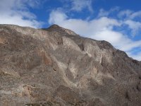
Walk the dirt road NW from the signed trailhead through a notch. Your goal is to reach the saddle between the lighter colored foreground hill in the photo and the main Moapa peak formation. The cairned route follows the major drainage to the right of the light colored peak. From the saddle head up onto the main peak following the easiest path, and through a short headwall to reach a NE trending ramp. Follow the widening shoulder then hike along the base of a steep light colored wall until you can gain the summit plateau where you'll find the narrow ridge leading SW to the summit proper. The ridge is similar in nature to (but easier and much shorter down than) Matthes Crest.


Trip Report
The weekend rolled around, and once again it was looking to be wet. Having just returned from a work trip I was unmotivated to drive far enough south to completely avoid the storms, so I resigned myself to working on the house Saturday and started looking at forecasts and topo maps within a few hours drive for Sunday. Mesquite's forecast called for 0% chance of rain and near 70F temps, and there were many mentions of a fun ridge traverse on nearby Moapa Peak. That sounded perfect.
I drove out Sunday morning, as always admiring the Virgin River Gorge on the drive south. I had briefly contemplated checking out the gorge the night prior, but didn't want to have to figure out how to circumvent the now raging Virgin River. Before too long I reached the desolate Carp-Elgin exit, hoping the roads wouldn't be too muddy or washed out. Other than a truck parked off in the distance at the base of Sheep Canyon Reservoir I saw no one. The road was in reasonable condition and the partial cloud cover brought out the desert colors. The trailhead was marked with a sign and the remnants of an old mining operation.


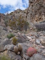
From a distance the Mojave Desert always appears dull and barren, but upon closer inspection reveals colorful plant life and fossils.


Instead of the drainage I headed straight up the whiteish hill to check out the cliffs. The diversity of invertebrate fossils was incredible.


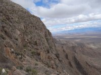
I contoured around the summit of the hill and joined the regular route at the saddle. The views of Moapa's jagged cliff face were incredible. I found a weakness through the lower headwall and was soon at the ramp that leads to the prominent peak shoulder I could see from the valley.


I joined the summit plateau and skirted the base of some steep cliffs.


Finally I reached the much applauded summit ridge. It was a combination of a few scrambly moves coupled with exposed sidewalk walking, short but fun.


After taking in the views I headed back, retracing my steps. The clouds were more dispersed, and the cliffs lit up in the late afternoon light. This time I took the normal route down the drainage. I returned to my car and caught a final shot of the blooming Joshua trees on the way out.


Start/end: Moapa Peak trailhead
Mileage: ~7.3 miles
Elevation gain: ~3400'
Navigation: Peak and major landmarks are visible from the parking lot. Some cairns, faint trail in spots, but helpful to be able to have some peak route-finding skills.
Filterable water: none
Designation: Wilderness Area (Mormon Mountains)
Fees: none
Annoyances: ticks
Nearest town/gas: Glendale or Mesquite, NV
Date hiked: 03 Mar 2019
More info: HW Stockman's beta
General Route & Map
Recommend high clearance and/or a skid plate to approach the trailhead. The trailhead is at 36.834455, -114.441643. From the Carp-Elgin exit off of I-15 (exit 100) take the main dirt road heading NW directly from the exit.
Walk the dirt road NW from the signed trailhead through a notch. Your goal is to reach the saddle between the lighter colored foreground hill in the photo and the main Moapa peak formation. The cairned route follows the major drainage to the right of the light colored peak. From the saddle head up onto the main peak following the easiest path, and through a short headwall to reach a NE trending ramp. Follow the widening shoulder then hike along the base of a steep light colored wall until you can gain the summit plateau where you'll find the narrow ridge leading SW to the summit proper. The ridge is similar in nature to (but easier and much shorter down than) Matthes Crest.
Trip Report
The weekend rolled around, and once again it was looking to be wet. Having just returned from a work trip I was unmotivated to drive far enough south to completely avoid the storms, so I resigned myself to working on the house Saturday and started looking at forecasts and topo maps within a few hours drive for Sunday. Mesquite's forecast called for 0% chance of rain and near 70F temps, and there were many mentions of a fun ridge traverse on nearby Moapa Peak. That sounded perfect.
I drove out Sunday morning, as always admiring the Virgin River Gorge on the drive south. I had briefly contemplated checking out the gorge the night prior, but didn't want to have to figure out how to circumvent the now raging Virgin River. Before too long I reached the desolate Carp-Elgin exit, hoping the roads wouldn't be too muddy or washed out. Other than a truck parked off in the distance at the base of Sheep Canyon Reservoir I saw no one. The road was in reasonable condition and the partial cloud cover brought out the desert colors. The trailhead was marked with a sign and the remnants of an old mining operation.
From a distance the Mojave Desert always appears dull and barren, but upon closer inspection reveals colorful plant life and fossils.
Instead of the drainage I headed straight up the whiteish hill to check out the cliffs. The diversity of invertebrate fossils was incredible.
I contoured around the summit of the hill and joined the regular route at the saddle. The views of Moapa's jagged cliff face were incredible. I found a weakness through the lower headwall and was soon at the ramp that leads to the prominent peak shoulder I could see from the valley.
I joined the summit plateau and skirted the base of some steep cliffs.
Finally I reached the much applauded summit ridge. It was a combination of a few scrambly moves coupled with exposed sidewalk walking, short but fun.
After taking in the views I headed back, retracing my steps. The clouds were more dispersed, and the cliffs lit up in the late afternoon light. This time I took the normal route down the drainage. I returned to my car and caught a final shot of the blooming Joshua trees on the way out.