Millard Canyon "easy exit"?

regehr

Member
Joined
Mar 28, 2012
Messages
2,221
I'm intrigued by a loop hike in upper Millard Canyon, shown in pink below. It is described in Map 6 in Kelsey's Robbers Roost book 3e. The route into Millard (right side, overlaid with a Udink gps track in blue) looks pretty straightforward, but the "easy exit" looks dicier in the imagery. Has anyone done it? Looks probably safest (and perhaps more scenic) to do the route in reverse.

Screenshot from 2017-10-08 10-57-03.png
 
I was going to do a quick hike down there a couple years ago to check out the Doug firs but chose the wrong spot to drop down through the Navajo. I would have had to climb back up and drop down again and was short on time so I bailed, but the point is, as is usually the case, it’d probably be a lot easier to find coming up. You drop a decent bit from the rim getting to that point and it’s hard to see with all the domes etc where the drop in is from the top and you can’t just walk the rim to find it.

Worst case you could just ride the Kayenta bench express back around to your known entrance if it looked more spicy than you hoped for on the way up.
 
Worst case you could just ride the Kayenta bench express back around to your known entrance if it looked more spicy than you hoped for on the way up.

Good point-- as long as the kayenta bench goes, there's no problem.

What is it about navajo anyway? I've spent quite a few hours wandering around these trying to find the way, including one time trying to find a way off the San Rafael reef where I started to get legitimately worried.
 
Yeah all five or six times I can think of where I’ve spent a couple hours trying to find a route has been Navajo from the top. I think it’s because of the dome nature, so you usually have poor visibility from where you are, plus there are often a lot of slabs that look like they go but don’t.

(Still #1 on my strata power rankings tho :D)
 
I'm intrigued by a loop hike in upper Millard Canyon, shown in pink below. It is described in Map 6 in Kelsey's Robbers Roost book 3e. The route into Millard (right side, overlaid with a Udink gps track in blue) looks pretty straightforward, but the "easy exit" looks dicier in the imagery. Has anyone done it? Looks probably safest (and perhaps more scenic) to do the route in reverse.

View attachment 58449
I'm looking for the Easy Entrance! I think Millard Canyon would be a great packraft entry point to the Green. So how gnarly IS that talus slope, any tips for finding the correct descent route? With raft, pfd etc my pack will be big and heavy...Sounds like a fair number of attempters bail at the big descent? Anyone got a gps track? Going in April (if the govt re-opens)
 
pretty sure @Udink had his GPS turned on when dropping into Millard
I wanted to do this loop last spring but ended up doing something different
 
That looks fun! Never considered it. Thanks for the info. Topo makes it look very reasonable with the Kayenta contour lines so wide. Reminds me of Hellroaring loop on the other side of the Green
 
I replied to a private message from kayakdave with this info, but figured I'd post it here for anyone interested:

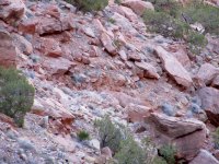
I didn't descend the talus slope, but did hike a loop below the rim from the road. A friend who was with me did descend the slope, and it looked pretty scrambly (see photo). It didn't look like there was much of a trail through the talus. I don't remember any of the loop I hiked being too sketchy, but I was only carrying a light day pack.

IMG_3433.JPG

There's another trail, the Devil's Slide Trail, that enters lower Millard Canyon much closer to the river. It's quite a distance from the road, but still much shorter than descending all of Millard Canyon from the upper trail that I've been on. There are a lot of switchbacks through the talus, which are visible in Google Earth in the historical imagery (5/2012 and 6/2013).

The attached kml/gpx files have my GPS track for the upper trail, as well as a couple of waypoints for the Devil's Slide Trail.
 

Attachments

  • Millard Canyon.gpx
    59.9 KB · Views: 21
  • Millard Canyon.kml
    23.9 KB · Views: 16
Similar threads
Thread starter Title Forum Replies Date
Udink Bluejohn Spring and Millard Canyon Trail Hiking & Camping 0
Kullaberg63 circling horseshoe/millard via bike and packraft Everything Else 9
J Reflection Canyon Trip Planning 3
fossana Found: prescription glasses near the top of the Flipoff Canyon approach General Discussion 5
Spud Salt Creek Canyon question Trip Planning 11
B Buckskin gulch/Pariah canyon Carpool Trip Planning 0
TractorDoc Paintbrush Canyon / Cascade Canyon Loop -- Grand Teton NP September 11, 2023 Hiking & Camping 9
Kullaberg63 15 day canyon route Backpacking 13
Titans Tricked in the canyon! Hiking & Camping 5
TrailScot Dayhiking the Under-the-Rim Trail - Bryce Canyon NP - October 2023 Hiking & Camping 4
Janice Such a GRAND Canyon - Deer Creek / Tapeats / Thunder River Backpacking 21
M Mee/Knowles Canyon Loop, Grand Junction Colorado Backpacking 4
OldBill Short hike at the Grand Canyon of Pennsylvania Hiking & Camping 1
S Paria Canyon- Whitehouse to Lees Ferry, Oct 18 to 21, 2023 Trip Reports 0
scatman Yellowstone's Thorofare, Headwaters of Thorofare Creek, Majo Pass, Younts Peak, Bob's Canyon, and Cub Creek - August 9, 2023 - Days 7 through 10 Backpacking 34
scatman Yellowstone's Thorofare, Headwaters of Thorofare Creek, Majo Pass, Younts Peak, Bob's Canyon, and Cub Creek - August 9, 2023 - Days 1 through 6 Backpacking 56
A Bowdie Canyon Trip Planning 10
TheMountainRabbit Silas Canyon (Popo Agie Wilderness) - August 2023 Backpacking 3
J Paria Canyon - One Day Trail Trip Planning 10
Bob The New Grand Canyon Trip Planning 1
WhozWutz Invite Horse Canyon Needles Meet Up (Members Only) 1
BJett Part 3 - Tour de Canyon Country. Lower Escalante Loop Hiking & Camping 0
BJett Part 2 - Tour de Canyon Country. Swell Times Hiking & Camping 0
BJett Part 1 - Tour de Canyon Country. Cedar Mesa. Hiking & Camping 8
Gretchen Millward Trachyte Creek via Woodruff Canyon, April 2023 Backpacking 9
F Grand Canyon hermits rest to granite rapids to bright angel Trip Planning 10
gnwatts Stillwater Canyon On The Water 11
shredhiker Kings Canyon July 2022 Kearsarge, Rae, & Sixty Lakes Backpacking 8
J Info needed: Bown's Canyon, Long Canyon Trip Planning 8
Gretchen Millward Cheesebox Canyon, Oct. 2022 Backpacking 14
Stickerbumper Fold Canyon Middle Exit Trip Planning 9
Janice Professor Creek / Mary Jane Canyon - mid April? Trip Planning 0
D Horseshoe Canyon or San Rafael Swell? Trip Planning 9
scatman North Ridge of City Creek Canyon - February 4, 2023 Hiking & Camping 17
scatman South Ridge of City Creek Canyon - January 28, 2023 Hiking & Camping 4
NorthwestWanderer 8 Day High Sierra trek : Humphreys Basin, Star Col, Granite Park, Lake Italy & Piute Canyon 6/25-7/2/22 Backpacking 7
T Amazing Discovery in Utah-Glen Canyon Trip Planning 65
Titans What’s your unfinished business? Hard canyon access, mtn peak, you name it! General Discussion 54
SteveR Big Spring-Elephant Canyon dayhike. With free bonus vacation pix! Hiking & Camping 13
Stephanie B Dirty Devil River Impassible at Poison Springs Canyon Off Road 0
LarryBoy Is there anything technical in White Canyon above the Black Hole? Trip Planning 16
dennisrodman A week in the Grand Canyon / Boucher / Hermit / Tonto Trail Trip Planning 4
XID_AZ Kanab Creek Wilderness - Sowats Canyon - Mountain Sheep Spring Trip Planning 6
travel2walk Yellowstone: Bechler Canyon, Aug 12-15 2022 Backpacking 21
balzaccom Mok Canyon Solitude for my birthday Backpacking 0
XID_AZ FiftyMile Canyon Sand slide Trip Planning 8
chandlerwest Hells Canyon - Jet Boat On The Water 0
futurafree Grand Canyon norovirus General Discussion 6
H location of thirteen faces-horse canyon Utah Hiking & Camping 4
Bob Teton Canyon Bear General Discussion 3

Similar threads

Back
Top