- Joined
- Dec 23, 2013
- Messages
- 4,114
A day after coming off a two week canoe trip around Yellowstone Lake with my daughter, I met up with my wife, along with @Artemus and his wife Becky for a go at the Mary Mountain Trail in Yellowstone National Park. The Mary Mountain Trail crosses the north end of Hayden Valley and the Central Plateau in Yellowstone and is considered by many to be the premier day hike in Yellowstone at 20.2 miles in length. It is also known for its excellent Grizzly Bear habitat, Bison herds, wolf packs and more.
This would be my third time hiking Mary Mountain over the years and my sixth visit to Mary Lake which is situated at just about the halfway point up on the plateau. On this hike though, we would head off-trail a short distance to check out Violet Hot Springs to bring our total mileage to 21.1 miles for the day.
We began our hike around 7:50 am, starting at the Mary Mountain Trailhead on the east end of the route, just west of the Yellowstone River were we got to observe a Blue Heron on its banks. It was a crisp 39 degrees at the trailhead, but once we started hiking things warmed up nicely. Highlights of the hike included Bison of course, but also a Grizzly Bear back in the western reaches of Hayden, Violet Hot Springs, and lots of waterfowl, including Canadian Geese and Sandhill Cranes. While we didn't manage to run into any wolves, their tracks kept us company all along the trail from east to west.
We stopped at the Mary Mountain Patrol Cabin at Mary Lake for lunch before heading down to Nez Perce Creek and out in Lower Geyser Basin.
Here are some shots of our hike.

Overview map of our route

The Mary Mountain Trailhead in Hayden Valley

Obligatory group shot (minus one) before we get started.

Heading out through Hayden Valley. How did I get so far behind the group? Cold knees perhaps?")

Canadian Geese unsure of our intent.

Looking back southeast towards thermal activity and Sulphur Mountain

Making our way through the eastern potion of Hayden Valley

The wide expanse to the west of us along the north end of Hayden Valley

The only post trail marker left standing. The Park Service used to have more along the route, but the
Bison have a fondness for rubbing up against them and knocking them over. Over time the ones knocked
down were not replaced.

We'll this might be problematic - Bull Bison on the trail.

Showoff! A little Scatman whispering sets him straight and allows us to pass.

Alum Creek

View to the south in Hayden Valley

A small fall on Alum Creek

Art and Becky begin our off-trail portion of the hike to Violet Hot Springs

Violet Creek. This creek flows from the hot springs to Alum Creek.

Art - Telling us the temperature of Violet Creek after sticking his pinkie finger in. Hot!

Thermal area of Violet Hot Springs

Hot springs

Hot spring

Heading towards the main hot springs

The main springs at Violet Hot Springs

Leaving Violet Hot Springs and heading back to the Mary Mountain Trail

Making our way through the hilly portion of the valley on the west end.

Art, making his way through the Goldenrod

Back on the trail.

Grizzly grazing on the hillside - 75 to 100 yards away

We got to enjoy watching him for a couple of minutes before he caught wind of us and moved on across
the hilltop.

Sheila, making her way up the last hill before the Buffalo Highway

Looking back to the east at the expanse of Hayden Valley

This guy almost got @Artemus

A look in the direction of the Trout Creek route through the southern reaches of Hayden Valley. In my
opinion the better route through Hayden Valley. Ssh, don't tell anybody.

Art decides that he is in for the long haul.

This trail marker marks the beginning of the Buffalo Highway

Wolf track

The Buffalo Highway

Finally reached Mary Lake (approximate halfway point)

The Mary Mountain Patrol Cabin

Our first lunchtime visitor at the patrol cabin

Mary Lake

Our second visitor at the cabin

The pit toilet at the patrol cabin. Not a finer pit toilet was ever constructed - a double seater at that.

Group shot at the cabin

They need to rename this the "Old Man Highway". Heading down the hill on the west side of Mary
Lake. By the way, what happened to the old man emojicon? @Nick?

Art and Becky, making their way down the old stagecoach road towards Nez Perce Creek. There is a story
about this stretch of the stagecoach road if anyone is interested in hearing it.

One of our lunchtime friends causing us some issues.

A little Scatman talk seems to calm his nerves so that we can pass.

Breaking out into the meadows along Nez Perce Creek

Can you make out the white sign on the tree at the edge of the meadow? It states that at this location
members of the Cowan party were taken by the Nez Perce Tribe on their way through Yellowstone heading
towards Montana and hopefully reaching Canada.

Looking back east at Sheila and Katie with Mary Mountain in the distance.

Logs across Cowan Creek. I think the creek was named after a famous BCP member @Ben for his hiking
prowess.

Art, heading off through the willows.

Crossing Magpie Creek

Ditto

Nez Perce Creek

Old footbridge across Nez Perce Creek

Old Man and the Bridge. I think I read that book many moons ago.

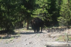
The last Bison encountered on our hike.

Nez Perce Creek towards the end of our hike

A thermal pool (Morning Mist Springs) in Culex Basin.

We made it! What a ragtag bunch at trail's end.

Celebrating a great day at the Bear Pit at Old Faithful

A teaser for the canoeing trip report.
The End.
This would be my third time hiking Mary Mountain over the years and my sixth visit to Mary Lake which is situated at just about the halfway point up on the plateau. On this hike though, we would head off-trail a short distance to check out Violet Hot Springs to bring our total mileage to 21.1 miles for the day.
We began our hike around 7:50 am, starting at the Mary Mountain Trailhead on the east end of the route, just west of the Yellowstone River were we got to observe a Blue Heron on its banks. It was a crisp 39 degrees at the trailhead, but once we started hiking things warmed up nicely. Highlights of the hike included Bison of course, but also a Grizzly Bear back in the western reaches of Hayden, Violet Hot Springs, and lots of waterfowl, including Canadian Geese and Sandhill Cranes. While we didn't manage to run into any wolves, their tracks kept us company all along the trail from east to west.
We stopped at the Mary Mountain Patrol Cabin at Mary Lake for lunch before heading down to Nez Perce Creek and out in Lower Geyser Basin.
Here are some shots of our hike.
Overview map of our route
The Mary Mountain Trailhead in Hayden Valley
Obligatory group shot (minus one) before we get started.
Heading out through Hayden Valley. How did I get so far behind the group? Cold knees perhaps?
Canadian Geese unsure of our intent.
Looking back southeast towards thermal activity and Sulphur Mountain
Making our way through the eastern potion of Hayden Valley
The wide expanse to the west of us along the north end of Hayden Valley
The only post trail marker left standing. The Park Service used to have more along the route, but the
Bison have a fondness for rubbing up against them and knocking them over. Over time the ones knocked
down were not replaced.
We'll this might be problematic - Bull Bison on the trail.
Showoff! A little Scatman whispering sets him straight and allows us to pass.
Alum Creek
View to the south in Hayden Valley
A small fall on Alum Creek
Art and Becky begin our off-trail portion of the hike to Violet Hot Springs
Violet Creek. This creek flows from the hot springs to Alum Creek.
Art - Telling us the temperature of Violet Creek after sticking his pinkie finger in. Hot!
Thermal area of Violet Hot Springs
Hot springs
Hot spring
Heading towards the main hot springs
The main springs at Violet Hot Springs
Leaving Violet Hot Springs and heading back to the Mary Mountain Trail
Making our way through the hilly portion of the valley on the west end.
Art, making his way through the Goldenrod
Back on the trail.
Grizzly grazing on the hillside - 75 to 100 yards away
We got to enjoy watching him for a couple of minutes before he caught wind of us and moved on across
the hilltop.
Sheila, making her way up the last hill before the Buffalo Highway
Looking back to the east at the expanse of Hayden Valley
This guy almost got @Artemus
A look in the direction of the Trout Creek route through the southern reaches of Hayden Valley. In my
opinion the better route through Hayden Valley. Ssh, don't tell anybody.
Art decides that he is in for the long haul.
This trail marker marks the beginning of the Buffalo Highway
Wolf track
The Buffalo Highway
Finally reached Mary Lake (approximate halfway point)
The Mary Mountain Patrol Cabin
Our first lunchtime visitor at the patrol cabin
Mary Lake
Our second visitor at the cabin
The pit toilet at the patrol cabin. Not a finer pit toilet was ever constructed - a double seater at that.
Group shot at the cabin
They need to rename this the "Old Man Highway".
Heading down the hill on the west side of MaryLake. By the way, what happened to the old man emojicon? @Nick?
Art and Becky, making their way down the old stagecoach road towards Nez Perce Creek. There is a story
about this stretch of the stagecoach road if anyone is interested in hearing it.
One of our lunchtime friends causing us some issues.
A little Scatman talk seems to calm his nerves so that we can pass.
Breaking out into the meadows along Nez Perce Creek
Can you make out the white sign on the tree at the edge of the meadow? It states that at this location
members of the Cowan party were taken by the Nez Perce Tribe on their way through Yellowstone heading
towards Montana and hopefully reaching Canada.
Looking back east at Sheila and Katie with Mary Mountain in the distance.
Logs across Cowan Creek. I think the creek was named after a famous BCP member @Ben for his hiking
prowess.
Art, heading off through the willows.
Crossing Magpie Creek
Ditto
Nez Perce Creek
Old footbridge across Nez Perce Creek
Old Man and the Bridge.
I think I read that book many moons ago.The last Bison encountered on our hike.
Nez Perce Creek towards the end of our hike
A thermal pool (Morning Mist Springs) in Culex Basin.
We made it! What a ragtag bunch at trail's end.
Celebrating a great day at the Bear Pit at Old Faithful
A teaser for the canoeing trip report.
The End.
Attachments
Last edited:
