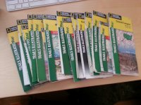
Maps for Spring trip

baltocharlie

Member
Joined
Dec 21, 2012
Messages
324
Hey folks: I've been lurking for a bit and recently posted myself in the noobie intro. I will be doing a trip this spring(April or May) to southern Utah. Plan to mix it up a bit with Mt biking and hiking/basckpacking/canyoneering. At this point I plan to go into the Escalante area for the hiking part and Moab for the biking. So as I prepare I need a good map. What map is best to do do some hiking/backpacking and canyoneering in this region. Will 1 do it or will I need a few to cover the region? There is a Nat Geo one that looks good but not certain it will be good enough for a 2-3 day backpacking trip. @1:75,000 not exactly detailed scale. I'm thinking 1:25,000 or so would be better. Maybe get the Nat Gepo map and a GPS??
I see a book post about the region and will address a few needs there as well.
Lots more Q's to come about canyoneering as well.
Thanks, great site.
Charlie(old but still cranking)
 
This thread helped me a ton: http://backcountrypost.com/forum/index.php?threads/mapping-resources.42/

I used the links to the free Utah USGS maps (http://gis.utah.gov/data/usgs-scanned-topographic-maps-drgs/) and successfully calibrated a couple to OruxMaps on my phone (kinda complicated, but doable). Took it with me on my last trip and it worked fine. For back up, I printed the bits that I needed on a color printer and put them in a zip lock. If you don't want to rely on your phone GPS for an overnighter, I'm pretty sure you can load them into another GPS. I can't help you there but I'm sure someone else here can.

I've used the Trails Illustrated maps for bike trips before and they worked fine. You are right though... not tremendously detailed.

For simple and free on-line recon, I've really started to like the BLM geocomunicator interactive map. Check the box for the "topo map NGS" base map, zoom in, and you'll find that the bottom layer is a very detailed topo map that you can scroll around a la Google maps. Plus there's another check box that let's you overlay a shade for BLM managed land.
 
I've spent quite a bit of time exploring the Escalante. The Escalante Trails Illustrated is an excellent map, highly recommended. Sure, it lacks the detail you get out of a USGS quad but it's awesome for the overall picture. I also find that the extra detail from a quad is often not needed there because of the nature of being down in a canyon. Still pretty easy to identify features, etc. and overall navigation isn't difficult.

For quads, I've really come to appreciate the maps I create on MyTopo Map Pass. The user interface leaves much to be desired, but it's still pretty good at cranking out custom maps. I print mine on 11x17 and usually do an aerial map on the other side, also produced in MyTopo so it all lines up perfectly. It's $30 per year for that service so pretty reasonable if you get out a fair amount.

I do carry a GPS most of the time, a Garmin Oregon 450. It comes in handy for checking distances and getting a quick idea of where I"m at or what I'm looking for. I recently switch to an android phone with replaceable batteries so I'm thinking I'll use it for some trips this year. Probably not for tracking mileage but definitely for canyoneering trips where all I'm really doing is finding the entry to the canyon. I downloaded Backcountry Navigator Pro for the GPS app. Haven't played around with it alot but it looks like it'll be awesome.

As for Mountain Biking, check out Skid Map. Zoom into Moab and watch the trails appear! http://skidmap.com/
 
Wow, that is the mother-load of map info on the links provided. That should keep me busy all weekend. Thanks Noun. I'm not much of a cell phone user so will have to start checking into GPS dedicated systems.
 
Thanks Nick, just replied to Noun's info as you were writing. I will look into the GPS you mentioned. I was playing with the skid map this weekend. It is awesome.
I'll probably buy the Escalante TI map to start planning, perhaps even the Canyonland/Moab TI maps. So you don't think a quad is needed. I've been down in some of the canyons before with very poor maps and kinda agree. However there were a few times I was scratching my head but always figured it out. I was thinking a good map is needed when I go to less traveled areas. Thanks again.
 
More GPS info!!! Quick GPS Q. What is the battery life life in a GPS vs a cell phones? Any GPS using LI 18650 batteries? They kick ass in my lights for night bike commuting. Cheap, small enough, rechargeable and pack a ton of power.
 
I buy the trail illustrated for every area I even intend to visit, they're awesome. And I would still probably carry a quad in most cases, I just don't think it's as important around Escalante as it can be in mountain environments or if you're doing more overland travel. Like I wouldn't bother for the straightforward hikes like Coyote Gulch, Escalante River Gorge, Harris Wash, etc. For ones that require a bit more overland navigation like Fiftymile, Davis, Scorpion, etc. Definitely go for the topo. And when in doubt, bust them all out! If it's easy to print your own, get that Map Pass subscription and go crazy. I print them for every backpacking trip for myself and everyone who joins me.

Note on the Canyonlands TI maps. They have an all-encompassing Canyonlands map or you can buy them individually for iSky, Needles and Maze. I recommend getting them individually. More detail. Also, for Needles and Maze, the terrain is so complex that is one place I would definitely also print the detailed quads.
 
More GPS info!!! Quick GPS Q. What is the battery life life in a GPS vs a cell phones? Any GPS using LI 181650 batteries? They kick ass in my lights for night bike commuting. Cheap, small enough, rechargeable and pack a ton of power.

My Garmin 450 takes two AA batteries. If I use AA lithiums, I can get nearly four full days of hiking, leaving it on and tracking me the entire time. If I use rechargeable NiMH AA's like the eneloops, I get more like 2 days of hiking. Still very good and that's with none of the 'battery saver' features turned on.
 
Thanks Nick: Plan to buy a bunch this wknd. In fact I bike home past an REI. Good to know about quad use or non-use in the areas mentioned. I was thinking about some of the straight forward Escalante hikes. I was also looking into the Canyonlands as it it closer to Moab thus less driving/more playing. But the canyons of Escalante are really drawing me down there. I'll buy the maps then plan some more.
GPS: battery time seems good. 4 days w/ lithium!! great to hear this.

Well everyone, you have helped me tremendously. I'll report back after spending the next few nights going over everything.
 
Chiming in to say I agree 100% with Nick. The TI maps and quads are not replacements for one another... both are valuable tools with separate (but overlapping) purposes. The individual TI maps for Canyonlands are the way to go.

And if you ever decide to go the phone GPS route, remember that radios you're not using in the backcountry (wifi, Bluetooth, cellular data) will leech power. If your device has toggles for each, use them.
 
BTW -- the Escalante Visitor Center has all the local quads on display with a great amount of notes added for popular/tricky routes and/or water sources. You might want to stop by and check them out before heading out. I like to take digital snapshots of key portions before I head out to have the latest notes with me on the camera I'm going to be using.

- Jamal
 
More GPS info!!! Quick GPS Q. What is the battery life life in a GPS vs a cell phones?

This is where the standard GPS prevails. I typically carry my phone in my pocket in airplane mode, and only flip on the GPS when I want to check my location, drop a way point, check the elevation, etc. Doing this, I can get a few days out of the battery, if I'm lucky. But if I were to turn the tracking on (GPS on full-time), I'd be lucky to get even a single day out of it.
 
That looks about like my TI maps collection.:) Love those!

Sent from my DROIDX using Tapatalk 2


Same here :)

I have quite a collection right now and each time I find a new one for a possible future hike in an area I've never been before I buy the map.
And it is so much fun to sit in front of one of these maps on rainy days and plan the next trip.

Sent from my DROID RAZR using Tapatalk 2
 
BNP blows the Gaia GPS app out of the water (at least on android) .

I tried Gaia on the iPhone, and yeah, it was terrible. I use MotionX-GPS now. It was a bit of a pain to download all the maps I wanted on it, but it functions more like a real GPS than Gaia does.
 
Well, stopped by REI last Thursday on the way to my train. I got talking to a salesman about GPS, then realized I was going to miss my train. So much to GPS!!! So I had no time to buy them. Plan to score a few this week though.
@Jamal: Good to know about the quads...even pictures, very nice
@phones apps: Wish I was more into the phone but am seriously leaning towards the dedicated GPS. And like lostlandscapes says the battery life is much improved.
I'll post when I score the TI. Then I will start mapping my spring trip. Thanks
 
Similar threads
Thread starter Title Forum Replies Date
F Maps for the Bob Marshall Wilderness Resource Discussions 3
U Funny experience with Maps on iPad Everything Else 1
westy NW Wyoming Maps Trip Planning 13
T Findings while searching Google maps General Discussion 9
TrektheWorld Gazetteer Maps Gear 4
Mike Jones Who uses paper maps? General Discussion 42
Wanderlust073 Black Ridge Canyons Wilderness / Rattlesnake Canyon maps Trip Planning 6
Jackson Google Maps 3D Detail General Discussion 4
isleroyaleguy White Clouds maps? Trip Planning 4
Mike Jones Built a Custom Map Board for protecting my maps while hiking Gear 9
Bob Create Maps/Routes for Android Resource Discussions 1
Backcountry Post Embedding CalTopo Maps Questions, Suggestions & Support 23
andyjaggy Printing Maps General Discussion 13
Mike K Maps on your phone (cheap or free) General Discussion 25
Absarokanaut NOAA June, July, and August Seasonal Outlook Maps General Discussion 16
steve Google Maps Engine Question on windows 8.1 laptop with USB gps General Discussion 0
uintahiker Google Maps vs KML file embed General Discussion 2
Nick New Google Maps Engine SUCKS General Discussion 12
Waynee-ack Maps? General Discussion 4
Backcountry Post Guess the spot: Maps Edition General Discussion 4670
Backcountry Post Embedding Maps Questions, Suggestions & Support 32
Nick Embedding Google Maps Questions, Suggestions & Support 0
Bob A Spring Pick Me Up General Discussion 6
westy Colorado Plateau spring Hiking & Camping 0
Bob Close to Spring day ...... General Discussion 3
SteveR Big Spring-Elephant Canyon dayhike. With free bonus vacation pix! Hiking & Camping 13
Bob Beartooth changes from Spring flooding General Discussion 2
XID_AZ Kanab Creek Wilderness - Sowats Canyon - Mountain Sheep Spring Trip Planning 6
SteveR A Tale Of Two Passes- A Spring Ski Tour in Alberta Winter Sports 4
regehr Lower Horseshoe Canyon and Big Spring Trip Planning 7
XID_AZ Poison Spring Canyon / Black Jump Fall 2021 Trip Planning 2
NorthwestWanderer 4 Days Backpacking Capitol Reef : Spring Canyon & Various side canyons Backpacking 5
kwc Adirondack Spring Hiking Continued Hiking & Camping 3
kwc Adirondack Spring Hike #? Hiking & Camping 1
danger02ward 2020 Spring Beatout traverse Winter Sports 18
J Mount Nutt Wilderness Cave Spring Area dayhike Nov 26, 2019 Hiking & Camping 0
montanaclimber advice Grand Canyon backpacking Spring 2020 Trip Planning 16
wsp_scott Dolly Sods spring Backpacking 9
fossana CO Plateau backpacking suggestions for spring run-off season Trip Planning 14
canadug Spring Break in the Mojave Desert Hiking & Camping 4
I Zion-South Utah Spring Break - March 9th-March 14th Trip Planning 15
WasatchWill Spring Break Ideas for Vernal/Dino Quarry NM Trip Planning 3
S Spring Canyon, Capitol Reef-vehicle shuttle Sun, Mar 24. Meet Up (Members Only) 0
Jazzy Joe Looking for Escalante Area Short Backpacking Suggestions Early Spring Trip Planning 21
b.stark CO/UT Spring 2018 - A trip to get away Backpacking 10
fossana Spring Canyon/Sulphur Canyon loop (Capitol Reef) Hiking & Camping 24
Dave Hells Half and Honaker, Spring 2018 On The Water 9
Perry Spring Day Hike up Boulder Creek Hiking & Camping 2
Outdoors24 Overnight in Lower Spring Canyon Backpacking 5
Devin Ashby Nate’s Canyon/ Spring Canyon San Rafael Swell Trip Planning 2

Similar threads

Back
Top