Lower Spring Canyon in Winter

Jackson

I ❤️ GYE
.
Joined
May 31, 2015
Messages
3,208
January 29 - 30, 2016

I had been itching to do an overnighter in the desert since late November, and it worked out that some friends and I would go the day after my birthday. Spring Canyon in Capitol Reef was the destination. My wife and I had planned on doing this one last Memorial Day weekend, but the risk of flash floods due to all the rain held us back.

We got to the park in the mid afternoon. The day was beautiful. Mid 30s and sunny. I walked in short sleeves into the visitor center to get our permit. After I asked about getting our permit, the ladies working immediately stopped me and asked if I brought any warm clothes. I assured them I had plenty. Glad they were looking out for me. They also said that no one had picked up a backcountry permit in over a week. Remind me to go to national parks in Winter more often.

We drove back up the road to the trailhead and headed out. I had my fleece pullover on by then, but we all had our jackets off after 5 minutes.

Looking West toward Torrey.
LrMobile0702-2016-0418137399118997405.jpeg

Coming up on Chimney Rock Canyon
LrMobile0702-2016-0415137396282606779.jpeg

In Chimney Rock Canyon. I loved the sheerness of the walls. Photos can never do justice for the scale of places like these.
LrMobile0702-2016-0412137393490750319.jpeg

This wouldn't end well if it were physically possible.
LrMobile0702-2016-0408137269190252468.jpeg

I liked how the light caught those tree branches.
0702-2016-0518140023628753864.jpeg

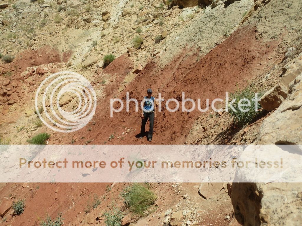
Getting closer to Spring Canyon
LrMobile0702-2016-0420137281292978682.jpeg
LrMobile0702-2016-0402137382797625355.jpeg LrMobile0702-2016-0459137379964788771.jpeg

I don't think I have any photos from the confluence of the two canyons. This is just a bit down Spring Canyon.
LrMobile0702-2016-0440137300704274608.jpeg


About 4 miles from the trailhead, we found a nice sandy spot next to an alcove and decided to set up camp. As we approached the area, a coyote darted out of the bushes and ran down the canyon. It was pretty cool to see.

Walking up to check out the spot that would become our camp site. Great views all around. No wonder the coyote was hanging out here.
LrMobile0702-2016-0445137305734632735.jpeg

We set up the tents and climbed up the steep slope on the opposite side of the canyon. Great views from up there.
LrMobile0702-2016-0451137312008433197.jpeg

Camp
LrMobile0702-2016-0448137368878008432.jpeg

The sun set and I took this crappy picture from the alcove.
LrMobile0702-2016-0458137318698276742.jpeg

The next morning, we set out down the canyon to see if we could find the spring marked on the NPS map. We first checked out the narrows that started very close to our camp site.
LrMobile0702-2016-0428135981022074937.jpeg
LrMobile0702-2016-0523139519447863540.jpeg
Looking into the narrows. They look much shallower than they are. They have two pour offs, and the first was impassable due to its height and the water and ice beneath it. We headed back up above them and took the bypass around them.
LrMobile0702-2016-0402137323137869369.jpeg

Continuing down the canyon.
LrMobile0702-2016-0406137326916307704.jpeg

I liked this rock.
LrMobile0702-2016-0410137330732327164.jpeg
We didn't find the spring. It was cool seeing a lot of the canyon though. We headed back toward camp, but we walked up the lower section of the narrows instead of going up and bypassing them. We learned that there was another pour off beneath the first we encountered. So we climbed up the lower pour off and walked up to the upper pour off. There was a lot of water and ice, so we couldn't get too close.
LrMobile0702-2016-0413137334071361457.jpeg

Coming back down the lower pour off. It wasn't too bad. The snow made it a bit tricky though.
LrMobile0702-2016-0417137338222715584.jpeg

Looking down the lower narrows.
LrMobile0702-2016-0430137351009013674.jpeg

Some cool circle formations on the rock.
LrMobile0702-2016-0424137345019427212.jpeg

I didn't take any more pictures after that. We headed back to camp, packed up, and headed out. It was a fun little overnighter and the solitude was wonderful. It would be fun to do the canyon as a shuttle hike sometime.
 
Sweet! How was the bypass around the narrows? I've heard mixed reviews of it being sketchy vs. not bad at all. And with snow on it?
 
Sweet! How was the bypass around the narrows? I've heard mixed reviews of it being sketchy vs. not bad at all. And with snow on it?
Thanks!

I'd give it a 3/10 on sketchiness, even with snow with no traction system (left my microspikes at camp). That spot that you always see pictures of where the trail is only about 6" wide was fine. If someone had pretty bad balance, if it were raining/muddy, or if it were covered in ice, I could see it being a bit worse. To me, the most challenging part of that small stretch was where a boulder was right next to the trail and kind of stuck out around shoulder level. There was ice on the trail next to it, so we had to kind of hug the rock to get around it. I didn't take any photos of that portion, but you can just barely see it at the left edge of the frame in this one I found.
https://liveandlethike.files.wordpress.com/2015/03/dsc04851.jpg

Anyway, people make it sound a lot worse than it is.
 
Cool, thanks. If you ask the rangers at the visitor center, they'll pretty much say "You're all going to die, go some place else, please. Pretty please. Seriously. We don't want to retrieve your corpses". I'd like to get back and do that one sometime. We tried once but they talked us out of it due to imminent drowning in the Fremont and no water the entire route (in March!).
 
Cool, thanks. If you ask the rangers at the visitor center, they'll pretty much say "You're all going to die, go some place else, please. Pretty please. Seriously. We don't want to retrieve your corpses". I'd like to get back and do that one sometime. We tried once but they talked us out of it due to imminent drowning in the Fremont and no water the entire route (in March!).

That's nuts that they tried to stop you from going. I clearly didn't ford the Fremont, but aside from that, this was not a difficult location at all. There's probably not a ton of water, but I'd imagine the spots underneath both pour offs frequently have water that time of year, given the depth of the stuff we saw. You do have to go a bit out of your way to get to it though. And it's called Spring Canyon, so if you look hard enough...
 
Here's that narrow portion of trail, @Nick.

2014-05-30%2023.24.43_zpsaqlrqucs.jpg


The pic doesn't show it, but all the dirt ends in an abrupt dropoff. As Jackson said, definitely sketchy for anyone with bad balance, especially if carrying a backpack, or in slick conditions. But fine otherwise for most people. The park staff have had to rescue people from in there before--even had to do a short haul once, though they managed to litter the guy back to the parking lot for that--so I understand why they're so conservative when people ask about places. Do it in the springtime if you can. The wildflowers are off the hook. I bet they'll be insane this year due to all our snow (see second pic below).


@Jackson, you're lucky you got here when you did. We had a significant storm last Monday. Dumped quite a bit of snow, and it's mostly still around. We had some lovely negative temps with the wind chill, too, since the breeze was about 35mph. :) Bit warmer now. Here's a pic from Capitol Gorge today, which gives an idea of what Spring Canyon probably looks like right about now.
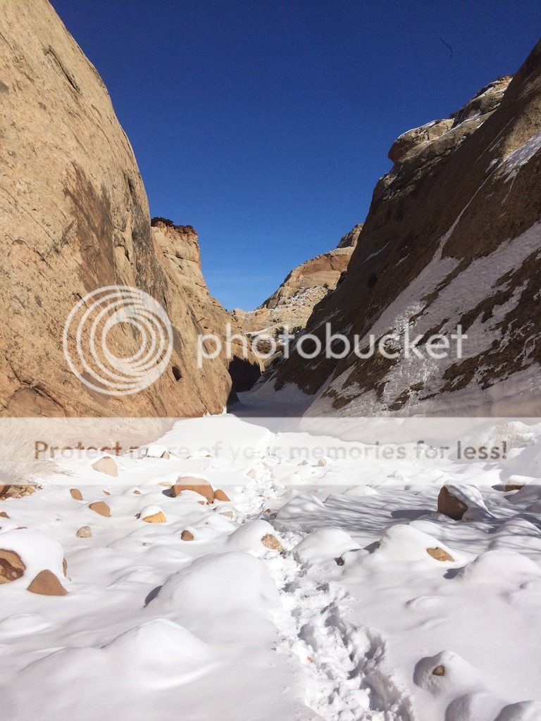
2016-02-07%2013.51.46_zpsba2sbvlx.jpg
 
The park staff have had to rescue people from in there before--even had to do a short haul once, though they managed to litter the guy back to the parking lot for that--so I understand why they're so conservative when people ask about places.

Yeah, I get why they need to be conservative, but my experience was too extreme. I think it's safe to say that I have a high experience level with Colorado Plateau hiking and backpacking and I made that as clear as I could to them and they treated me like nothing more than someone who had just stumbled drunk out of their camper trailer ready to see 'the canyonlands'. Being too conservative just leads to a reputation that they aren't being honest, which can backfire and make it so people just don't trust them. The occasional rescue is inevitable regardless of whether they choose to be honest with people or over inflate the dangers.
 
Oh, I do understand that. It can get pretty annoying to be talked to like that when you do actually know what you're doing. I've been on that end of conversations, too, just biting my tongue. I think most nat'l parks deal so much with people who have almost no idea what they're doing that the staff end up side-eyeing just about anyone who asks about the backcountry, regardless of experience level. I say if the weather etc. conditions are right and you feel good about it, just get your permit anyway and go. But I'm a bit of a rebel. ;) Or just do it as a day trip. It's only about 10 miles from Chimney Rock to the Fremont.

And yes indeed, there is a spring, a little up canyon of the confluence. I'd be surprised if there'd really been no water in the canyon at all in March, in the potholes at least, unless it had been extremely dry.
 
Nice little trip there! I'd love to pay a visit back up there in the winter, and again in the fall when all all the cottonwoods are glowing in gold. I have plans to repeat the trip I took solo through there last year with my wife this April assuming things work out with the in-laws watching our kids and dog for us. Fingers are crossed that weather will also be comparable to what I got last year. I'll have to keep my eyes open for that alcove you all claimed home for the night. When I was cutting through that section, much of my focus was just keep an eye out for the pour-offs and the famed bypass so as to not miss it.
 
Thanks!

I'd give it a 3/10 on sketchiness, even with snow with no traction system (left my microspikes at camp). That spot that you always see pictures of where the trail is only about 6" wide was fine. If someone had pretty bad balance, if it were raining/muddy, or if it were covered in ice, I could see it being a bit worse. To me, the most challenging part of that small stretch was where a boulder was right next to the trail and kind of stuck out around shoulder level. There was ice on the trail next to it, so we had to kind of hug the rock to get around it. I didn't take any photos of that portion, but you can just barely see it at the left edge of the frame in this one I found.
https://liveandlethike.files.wordpress.com/2015/03/dsc04851.jpg

Anyway, people make it sound a lot worse than it is.


I would agree with this, @Nick. I was a little bit nervous about what it would be like after reading descriptions about it. Many pictures and video of it out there make it look a lot worse than it really is, too. So I was pleasantly surprised to find it to be very tame for my expectations, and was very grateful. Still not something I'd ever want to do with a heavy (40+ lb) pack on, but with an adequately lightweight pack on, it was reallly pretty easy going for me, and I have quite a fear of heights myself. Maybe people talk it up to try and scare people away from doing it so as to preserve the solitude back up in there because it really is a neat little canyon. So in that case, let's all say it really is actually a 9/10 sketchy class 3 bypass. :D

Seriously though, I hope it can remain free from the crowds and not get publicized too much.

Love the pic @JulieKT posted of the bypass. That is one of the few pics I've seen that makes it look a lot less intimidating. Here's the only one I took looking back on it last year. You can barely see it in the image, but it weaves through the two little bushes on the right and traverses the slope in like fashion all the way back.

upload_2016-2-8_13-21-28.png
 
...We didn't find the spring. It was cool seeing a lot of the canyon though...

There is indeed at least a seasonal spring down in the lower canyon. I camped nearby it last year. Here's a shot downstream of it to show the kind of flow it puts out for a little way before it dries up a little further down canyon.

upload_2016-2-8_13-35-24.png

...And yes indeed, there is a spring, a little up canyon of the confluence. I'd be surprised if there'd really been no water in the canyon at all in March, in the potholes at least, unless it had been extremely dry.

And here's the proof for that one! This is what I believe is the perennial spring in the upper canyon right where it flows up out of the ground and runs down the wash for a ways before the water disappears back into the ground.

upload_2016-2-8_13-30-58.png


Oh, and sorry to hear about practically being shut down by the rangers when you attempted it, @Nick. The ranger I got my permit from was real cool and didn't seemed concerned about any dangers I could face at all. I just asked him how cold he thought it could get in the canyon and throughout the park that night and that dictated which sleeping bag I took on my trip. I also asked him about water in the lower canyon and he said what I pretty much knew already that sometimes there can be a flow in there for a bit but is often unreliable. To be honest, when it comes to concerns about forwarding the Fremont, I think the real threat has to be hypothermia and not being washed away and drowning. It was bone chilling cold even when it was just ankle deep on me in April. Burrr...:cold:
 
So in that case, let's all say it really is actually a 9/10 sketchy class 3 bypass. :D

Seriously though, I hope it can remain free from the crowds and not get publicized too much.
I agree entirely. All of Capitol Reef really is a gem. Especially when you consider how busy the other Utah parks generally are.

There is indeed at least a seasonal spring down in the lower canyon. I camped nearby it last year. Here's a shot downstream of it to show the kind of flow it puts out for a little way before it dries up a little further down canyon.
Wow! Pretty good volume of water right there. It must have been frozen or dry when we came through because we saw nothing like that. Thanks for sharing those photos.
 
Spring is one I've always had my eye on, but never pulled through. Looks real nice.
 
Thanks for sharing of your impressions, especially during the winter! :)
This canyon is on my radar too.
 
Similar threads
Thread starter Title Forum Replies Date
regehr Lower Horseshoe Canyon and Big Spring Trip Planning 7
Outdoors24 Overnight in Lower Spring Canyon Backpacking 5
Scott Chandler Chimney Rock-Lower Spring Canyon, Cap Reef NP Hiking & Camping 6
BJett Part 3 - Tour de Canyon Country. Lower Escalante Loop Hiking & Camping 0
fiber Lower Grand Gulch Pour-off Trip Planning 9
slieb Lower Muddy Creek in Winter? Trip Planning 7
regehr water in lower muley twist? Trip Planning 0
J Scrambles in the Lower Colorado River Corridor AZ/NV; Dec. 11-14, 2020 Hiking & Camping 5
Devin Ashby The Lower Gulch - Escalante (Seeking info on the route) Trip Planning 14
RyanP Lower Death Hollow next week (late May/early June), miscellaneous questions Trip Planning 16
Stephanie B Sixteen Room Ruin and Lower Butler Wash Hiking & Camping 15
Boognish Lower Death Hollow Narrows April 2018 Backpacking 17
fossana Sheep Bridge/Lower JEM trail (Virgin, UT) Conservation Project General Discussion 5
T Dark canyon - lower blm portion with pack goats?? Canyoneering 2
pstm13 Texas Pass Cirque of Towers Lower Wind River Range August 2018 Trip Planning 7
Ross West Canyon quicksand (a/one want to go lower West/Face/Labyrinth August? Trip Planning 3
Strawsome Lower Death Hollow at it's finest Backpacking 3
DiscGo Lower Watermaiden [Video] Hiking & Camping 5
RyanP Lower Death Hollow, mid-April Trip Planning 8
Ravialdo Lower Muley Twist water situation? Trip Planning 13
Udink Lower Horseshoe Canyon Hiking & Camping 0
Kullaberg63 Lower Dirty Devil Backpacking 7
Jackson Lower Red Castle Lake Backpacking 4
scatman Lower and Midway Geyser Basins plus Buffalo Meadows - Yellowstone National Park - June 26, 2016 Backpacking 5
BJett Lower Escalante Trifecta - Davis Gulch to Fiftymile Creek Backpacking 8
BJett Lower Escalante Trifecta - Willow Gulch to Davis Gulch Backpacking 14
mattvogt7 Lower Escalante Packraft Loop Backpacking 12
Nick Floating lower Cataract into Glen Canyon Trip Planning 2
mattvogt7 Lower Cataract Canyon Loop Backpacking 16
Parma Lower Salmon River - Hammer Creek to Heller Bar On The Water 7
lostlandscapes Lower Red Castle Lake -- 6/13/15 Backpacking 19
IntrepidXJ The Lower San Juan River On The Water 8
IntrepidXJ Lower Grand Gulch Backpacking 5
toejam Lower Sisquoc Loop Backpacking 7
ram Crash Site/Lower Hades Canyon 2-15-15 Canyoneering 1
LarryBoy Water Sources in Lower Grand Gulch Trip Planning 15
Ben wind river range, elkhart park to lower jean lake Backpacking 13
Dave December in Lower Muley Twist Backpacking 20
Udink Lower Price River Hiking & Camping 8
westerner54 Lower Grand Gulch, Below the Narrows Backpacking 3
IntrepidXJ Lower Calf Creek Falls Hiking & Camping 5
Nick Lower Black Box Trip Planning 0
BJett Lower Big Creek - Great Smoky Mountains National Park On The Water 2
Nick Lower Bells Canyon Hiking & Camping 3
Udink Lower San Rafael Hiking & Camping 4
Bill Lower Brimstone Gulch - Escalante Hiking & Camping 11
Cody Halls Creek Loop via Lower Muley and Red Slide Backpacking 16
slc_dan Lower-Lower Muley Twist 4/12/2013 Backpacking 14
Nick Lower Muley Twist vs. Upper Muley Twist Trip Planning 19
slc_dan Lower Salt Creek/Paul Bunyan's Potty Backpacking 11

Similar threads

Back
Top