maperson543
Member
- Joined
- Jan 14, 2024
- Messages
- 5
This note is delayed, but I was out and did it in May 2024. Finally have time to type out the notes I took when I did this hike. Am being overly detailed b/c the reports on this ledge are kinda all over the place.
For data points besides my own account: Ran into two folks who did it that same week and said it was no problem. Also ran into river rafters who had done it a few years back and they also said no problem.
I would say that I did it and went through with it, but--personally--I would not do it again. I'm well experienced in/around sketchy exposure and canyon entries/exits, but this one was a little too dangerous/exposed. It may have had to do with the recent flash/rain making the shale and gravel slippery (more below).
I would recommend that anyone who plans to do this have a solid backup plan of turning around. I originally came in Slickhorn 1 (to San Juan Ledge, then up the Lower Gulch exiting out at Government). If I was with a less experienced hiker, I probably would've turned around, gone back over the ledge trail along the river (a stunning/beautiful hike), explore and exit out Slickhorn 2 or 3 (also a very fun hike with tons to explore), and then hike back to Slickhorn 1. I've also heard there may be exit points along the river ledge to go up and over and then enter in at Shangri-Li, but I didn't see anything (though I also wasn't looking that closely). Note that there are also (dry) camping spots on the ledge so you could always camp on the ledge if out of time. There are one or two spots to get water while hiking the ledge; mostly on the half closer to Slickhorn. I know that there is a route out of Slickhorn, over the mesa, and then down into Shangri.
Ledge was far too exposed for me. I still did it, but there are really two options. You also can't really get a good photo b/c of the angles and rocks.
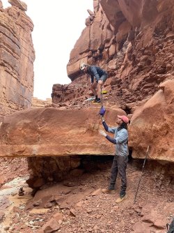
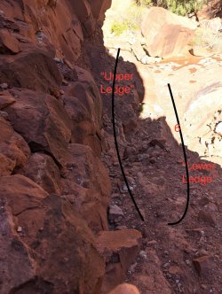
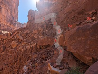
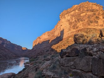
One option has you continuing on an upper ledge. I labelled that 2a and 2b in my photo. And it ends where the people in the second photo are dropping their packs. The photo with the people makes it look much safer than it was for me in real life (note that the people photo was taken some time ago). It flashed the day before and what I'll call the "upper ledge" was still wet. It's composed of loose small gravel and shale, but the cliff/it looked like it would be pretty steady when dry. It's probably about 20-ish inches, maybe 2 feet. So not too bad. This upper ledge has exposure, but it's not a straight drop into the bottom of the pourover. This is probably the safer route to go as it's about 5-10 steps forward and then you can drop your pack and shimmy/jump down as shown in the picture with people. I felt that this was too narrow/angled downward for me with a full pack. And it also appeared VERY loose after the rain. So loose that if I stepped on it with a full pack, the gravel (due to the angle) may give out and make me slip. One slip on this ledge and you would tumble likely down 40-50 feet. There's a chance you would fall onto what I'll call the "lower ledge", but the lower ledge was likely 12-16 inches in width and I'd doubt a person would catch themselves before tumbling the 40-50 feet down to serious injury. But again, two people that same week had said they did it so maybe I was missing something.
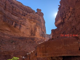
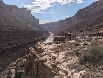
The second option is what I'll call the "lower ledge." It's also not ideal and the exposure is intense. It is narrower than the upper ledge. It's hard to describe, but this is what I numbered 3,4, and 5 in my picture. So it's narrow, and it does have more exposure than the upper ledge, but I felt it was ever so slightly safer. That's because it seemed possible to sit down and scoot with a pack, which would maintain stability. Even if gravel gave out I'd essentially be sitting down. And the gravel/rocks were certainly bigger and looked more stable than the upper ledge, which were more fine and silty. I chose this route. Butt scooted down very slowly being sure not to lean too far to the right (which was exposure and pretty much a straight fall down). I also tried to grip the rock on the left, though there is not much to grab. And I made it down to 5 (in my pic) where I was able to get up and easily walk to the 6 in my third picture.
All in all, this route really depends on your risk appetite. Make sure your pack is on tight and does not shift. I also would not be surprised if this becomes impassable in the next few years due to erosion and rain. For me, it's already practically there.
There could certainly be some guerrilla trail making, but would likely involve rope or a ladder as there is a solid lone tree to anchor to where the pourover is.
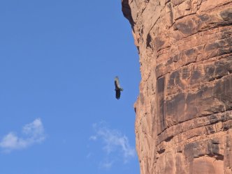
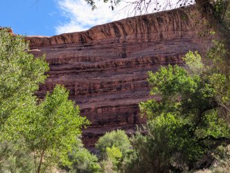
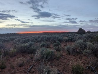
Regardless, it was a gorgeous hike and also adding pictures of things other than the ledge.
PS, 2 and 3 in my photos looks like it's a 45 degree angle and you can't walk or scoot down, but the picture is deceiving. It's more like 15 to 20ish degrees and not as steep as it looks since the picture makes it appear as if it's a straight drop down.
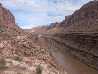
PPS Photo 001 is looking North as you come from the South/the river and heading north. Pourover is to your right. Photo 002 is looking back after you have taken either the lower or upper ledge. It's looking South. 003 is also looking South after you've crossed over the pourover.
For data points besides my own account: Ran into two folks who did it that same week and said it was no problem. Also ran into river rafters who had done it a few years back and they also said no problem.
I would say that I did it and went through with it, but--personally--I would not do it again. I'm well experienced in/around sketchy exposure and canyon entries/exits, but this one was a little too dangerous/exposed. It may have had to do with the recent flash/rain making the shale and gravel slippery (more below).
I would recommend that anyone who plans to do this have a solid backup plan of turning around. I originally came in Slickhorn 1 (to San Juan Ledge, then up the Lower Gulch exiting out at Government). If I was with a less experienced hiker, I probably would've turned around, gone back over the ledge trail along the river (a stunning/beautiful hike), explore and exit out Slickhorn 2 or 3 (also a very fun hike with tons to explore), and then hike back to Slickhorn 1. I've also heard there may be exit points along the river ledge to go up and over and then enter in at Shangri-Li, but I didn't see anything (though I also wasn't looking that closely). Note that there are also (dry) camping spots on the ledge so you could always camp on the ledge if out of time. There are one or two spots to get water while hiking the ledge; mostly on the half closer to Slickhorn. I know that there is a route out of Slickhorn, over the mesa, and then down into Shangri.
Ledge was far too exposed for me. I still did it, but there are really two options. You also can't really get a good photo b/c of the angles and rocks.
One option has you continuing on an upper ledge. I labelled that 2a and 2b in my photo. And it ends where the people in the second photo are dropping their packs. The photo with the people makes it look much safer than it was for me in real life (note that the people photo was taken some time ago). It flashed the day before and what I'll call the "upper ledge" was still wet. It's composed of loose small gravel and shale, but the cliff/it looked like it would be pretty steady when dry. It's probably about 20-ish inches, maybe 2 feet. So not too bad. This upper ledge has exposure, but it's not a straight drop into the bottom of the pourover. This is probably the safer route to go as it's about 5-10 steps forward and then you can drop your pack and shimmy/jump down as shown in the picture with people. I felt that this was too narrow/angled downward for me with a full pack. And it also appeared VERY loose after the rain. So loose that if I stepped on it with a full pack, the gravel (due to the angle) may give out and make me slip. One slip on this ledge and you would tumble likely down 40-50 feet. There's a chance you would fall onto what I'll call the "lower ledge", but the lower ledge was likely 12-16 inches in width and I'd doubt a person would catch themselves before tumbling the 40-50 feet down to serious injury. But again, two people that same week had said they did it so maybe I was missing something.
The second option is what I'll call the "lower ledge." It's also not ideal and the exposure is intense. It is narrower than the upper ledge. It's hard to describe, but this is what I numbered 3,4, and 5 in my picture. So it's narrow, and it does have more exposure than the upper ledge, but I felt it was ever so slightly safer. That's because it seemed possible to sit down and scoot with a pack, which would maintain stability. Even if gravel gave out I'd essentially be sitting down. And the gravel/rocks were certainly bigger and looked more stable than the upper ledge, which were more fine and silty. I chose this route. Butt scooted down very slowly being sure not to lean too far to the right (which was exposure and pretty much a straight fall down). I also tried to grip the rock on the left, though there is not much to grab. And I made it down to 5 (in my pic) where I was able to get up and easily walk to the 6 in my third picture.
All in all, this route really depends on your risk appetite. Make sure your pack is on tight and does not shift. I also would not be surprised if this becomes impassable in the next few years due to erosion and rain. For me, it's already practically there.
There could certainly be some guerrilla trail making, but would likely involve rope or a ladder as there is a solid lone tree to anchor to where the pourover is.
Regardless, it was a gorgeous hike and also adding pictures of things other than the ledge.
PS, 2 and 3 in my photos looks like it's a 45 degree angle and you can't walk or scoot down, but the picture is deceiving. It's more like 15 to 20ish degrees and not as steep as it looks since the picture makes it appear as if it's a straight drop down.
PPS Photo 001 is looking North as you come from the South/the river and heading north. Pourover is to your right. Photo 002 is looking back after you have taken either the lower or upper ledge. It's looking South. 003 is also looking South after you've crossed over the pourover.
Attachments
Last edited:
