I am planning a trip to the lower GG in April. We have entered most of the permitted routes and am looking for info on dropping into redman, water or deer canyon. Preferably without rappelling, lowering packs and medium spicy down climbs are fine. Thanks
Navigation
Install the app
How to install the app on iOS
Follow along with the video below to see how to install our site as a web app on your home screen.
Note: This feature may not be available in some browsers.
More options
Style variation
You are using an out of date browser. It may not display this or other websites correctly.
You should upgrade or use an alternative browser.
You should upgrade or use an alternative browser.
Lower Grand Gulch Entry Points
- Thread starter Cbates
- Start date
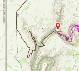
I have exited from Redman. There is one chimney up around a stuck boulder and a couple spots to hand up packs, but nothing too hard. At the very top there's an easy way in/out on the east side maybe ~200 ft down canyon from the dryfall.
These guys went to Water Canyon. I have a few collected GPS track that all enter that same fork they did, so you should find a way there.
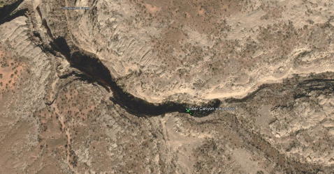
This is where I have the way down into Deer Canyon marked. I didn't do this personally and I can't find the report where I originally got it from so take that for what it is.

napatony13
Member
- Joined
- Feb 5, 2021
- Messages
- 210
When I was there a few years ago I tried Redman and couldn't find any way to get myself out. I tried the next canyon downstream and found a relatively easy way out. About halfway up the canyon you'll see a brushy bench above you on your left. Climb up there and follow that bench out to the mouth of the canyon. From there it's a few hundred yards to the final break up to the mesa top and abandoned road. That break is about 8' high. I headed to the first place that looked like it would go and was able to easily scramble up and get out with no problem. .
.
 .
.excellent! Thank youWhen I was there a few years ago I tried Redman and couldn't find any way to get myself out. I tried the next canyon downstream and found a relatively easy way out. About halfway up the canyon you'll see a brushy bench above you on your left. Climb up there and follow that bench out to the mouth of the canyon. From there it's a few hundred yards to the final break up to the mesa top and abandoned road. That break is about 8' high. I headed to the first place that looked like it would go and was able to easily scramble up and get out with no problem.View attachment 140458.
Boom! Thanks a ton. We shall return with reports and pics, wherever we choose to goI have exited from Redman. There is one chimney up around a stuck boulder and a couple spots to hand up packs, but nothing too hard. At the very top there's an easy way in/out on the east side maybe ~200 ft down canyon from the dryfall.
These guys went to Water Canyon. I have a few collected GPS track that all enter that same fork they did, so you should find a way there.
This is where I have the way down into Deer Canyon marked. I didn't do this personally and I can't find the report where I originally got it from so take that for what it is.
View attachment 140455
- Joined
- Dec 2, 2019
- Messages
- 200
I have exited from Redman. There is one chimney up around a stuck boulder and a couple spots to hand up packs, but nothing too hard. At the very top there's an easy way in/out on the east side maybe ~200 ft down canyon from the dryfall.
These guys went to Water Canyon. I have a few collected GPS track that all enter that same fork they did, so you should find a way there.
This is where I have the way down into Deer Canyon marked. I didn't do this personally and I can't find the report where I originally got it from so take that for what it is.
View attachment 140455
This looks to be very close to Michael Kelsey's suggested entry point for Deer Canyon.
- Joined
- Dec 2, 2019
- Messages
- 200
When I was there a few years ago I tried Redman and couldn't find any way to get myself out. I tried the next canyon downstream and found a relatively easy way out. About halfway up the canyon you'll see a brushy bench above you on your left. Climb up there and follow that bench out to the mouth of the canyon. From there it's a few hundred yards to the final break up to the mesa top and abandoned road. That break is about 8' high. I headed to the first place that looked like it would go and was able to easily scramble up and get out with no problem.View attachment 140458.
I believe that this is unofficially called Rope Canyon. I tried to descend here a few years ago but didn't make it, so it's great to see this entry/exit route. This is definitely a good sneak route to reach the section of GG around Shaw Arch.
napatony13
Member
- Joined
- Feb 5, 2021
- Messages
- 210
Good to know. Yes, if I remember correctly going up the canyon there was an impassable pour off, but looked to be possible to skirt it on the left. There was about a 5' sheer ledge that I tried to hop up onto but with nothing to grip on top I couldn't make it. My original goal was to make it to Shaw, but elected to cut my trip short. Maybe if there's a next time.I believe that this is unofficially called Rope Canyon. I tried to descend here a few years ago but didn't make it, so it's great to see this entry/exit route. This is definitely a good sneak route to reach the section of GG around Shaw Arch.
I would like to know if any of you good folks attempted a route leading to Grand Gulch via north of the first ford of Water Canyon tha may get me down to the bottom of Grand Gulch just noth of the Big Panel also known as the Red, White and Blue panel in Kelsy's book. I have tried all of the forks of water canyon and they all lead to a boulder field which is almost impassable. Thanks for your assistance
Don't like ads? Become a BCP Supporting Member and kiss them all goodbye. Click here for more info.
