Lower Death Hollow next week (late May/early June), miscellaneous questions

RyanP

Member
Joined
Mar 1, 2015
Messages
577
I am hoping to do the Boulder-Mail-Trail/Lower-Death-Hollow route (BMT to HWY 12 bridge) next week (a few days after Memorial Day) and have a few last-minute planning questions:

1. We will be spending a night or two in Death Hollow, so I'm worried about flash floods. What websites/locations would you check before doing a trip like this? I was planning on checking weather.gov ("Death Hollow") before leaving on the trip, just like I do before any backpacking trip, but if there are any other websites or locations (how far upstream, etc.) that you would recommend, please let me know. I know in general I should avoid canyons like this when there is rain in the forecast, but what percent chance of rain would you use as a cutoff in making the go/no-go decision? This is my first time planning a backpacking trip in an area with real flash flood danger, so any tips are greatly appreciated.

2. Is it recommended/required to carry out your waste in Death Hollow? I don't have a feel for if there are adequate spots of land far enough away from the water to properly bury your waste when going through Death Hollow. I'm assuming that one can dig a good enough hole on the other stretches (the BMT and along the Escalante). I was planning on bringing about 1 wag bag per person, but would love to leave them at home if they're not needed.

3. If anyone has been there recently and can report on the water level, please let me know. I'm planning on roughly knee-deep water, but if it's much worse, I may bail, since I'll be taking my 11-year-old son. I know the water isn't usually too deep down there, but with all the snow this year I was hoping to hear if anyone has been down there recently.

4. Are the bugs (mosquitos? gnats? biting flies? no-see-ums?) getting bad down there yet? If so, if anyone has any recommended campsite locations down there to avoid the bugs, please let me know!

5. Speaking of campsites, if anyone has any recommendations of where we can camp near the trailhead the night before the trip (1-2 small tents) please let me know. My understanding is that you can't camp at the trailhead itself?

6. We will be doing a bike shuttle so that we can do the point-to-point route with a single vehicle. I would normally prefer doing the bike ride before starting the hike, to avoid the uphill bike ride during the heat of the afternoon on the last day. However, if I think one of us could likely hitch a ride from the HWY 12 bridge back to the BMT trailhead, I will just keep the bike at the end of the route and try to hitch a ride back to the car. So my question is, what are my chances of successfully hitching a ride there on a Saturday afternoon? I have no idea how busy that road gets.

Thanks in advance for any feedback!
 
Chances of hitching are very, very good on a weekend. I've never waited more than an hour for a ride on Hwy 12. That stretch shouldn't be a problem. I wouldn't bother bringing a bike unless you are very, very pressed for time in case the hitch takes longer than expected.
 
I spent a week near the confluence of the Gulch and the Escalante last week. Surprisingly no bugs. The river level fluctuated considerably between 2-4 feet. A mix of rainfall and snowmelt. This week temps are lower so river level should be managable. Search “escalante cfs” and a suitable website will pop op for you. Never a real issue with a good hiking stick. Your son will require some assistance at the deeper crossings. Teamwork makes the dream work!
 
I've done a week long hike starting at the BMT, down through the canyon, and out at the HWY 12 bridge twice now. Both trips were finishing up right about this time of the month.

1. I'll leave this to others to speculate on.

2. I carried my trash with. With this being a canyon, it seems to me that any flood would just dig up any trash that is burried.

3. Unsure

4. Never had an issue with bugs this time of year.

5. Plenty of places to camp at the BMT trailhead, and as far as I know it's allowed.

6. I usually drop a car off at the HWY 12 bridge, then hitch hike back up to the top before camping for the night and starting the hike the next morning. In my two combined trips of doing this, only one car has passed by and not stopped to give me a lift. I think I have really good luck though, as I have heard other people taking well over an hour.
 
Most sections below the BMT is wide enough that there isn’t huge flash flood risk. Above there where there are more narrows sections are where it’d be more of a consideration. You shout have an issue finding campsites in some of the wider sections.
 
Gnats or some sort of sneaky lil biting things were terrible last week, right down near the bridge. They tried to eat me alive. There's also rain happening in the general area right now, and a good amount of more snow falling up on Boulder Mountain. Storm weather will be happening all this week, according to forecasts. Definitely check the river water levels right before you head out, especially since it should be warming up again next week, meaning more snowmelt will happen.
 
Thanks everyone!

Kyle---I will definitely pack out all my garbage; in question #2, "waste" was referring to our poop, not our garbage.

LarryBoy---Thanks for the tip. We probably won't bring a bike after all.

Duffbuddha---2-4 ft sounds like a bit more than I was hoping for. I'll keep on eye on the water level (thanks for that tip), and cross my fingers that it will go down in the next week

Brendan S---Thanks, it sounds like there is only one relatively short section where flash floods are a big danger. I've probably been worrying too much about flash floods and too little about the water level for hiking with my son.

JulieKT---thanks for the update. Sounds like bugs will likely be really bad in some places (near the Escalante/Sand Creek?) and not in others. I'll definitely keep an eye on the water level.
 
If you're going in from lower BMT (Escalante River trailhead near town), there are campsites on the side roads along highway 12 toward Boulder. If you end up with a tight weather window, you could go out the sneaker exit instead. There's nice rim camping at the exit. In that case the bike shuttle from the exit to the Escalante River TH is mostly downhill. I locked my bike to the utility station just up the road.
 
One tip: bring little floaties (cheap Wally World pool toys work well). Beavers often dam up the steam and make deeper pools. With your little duck floaty thing you can keep more or you and your stuff dry.
 
fossana---I think the sneaker route is above my group's capabilities (that website says it's class 3/4-), but thanks for the tip. If the weather isn't good then we'll end up going somewhere else entirely.

LarryBoy---I hadn't even considered bringing something like that. Sounds like I need to make a trip to Walmart!
 
When I google "Escalante CFS", the following .gov website comes up: https://waterdata.usgs.gov/ut/nwis/uv?site_no=09337500. This is nice because it shows the current CFS numbers compared to the median values. However, this is for the Escalante River as opposed to Death Hollow. Should I expect the trends to be similar in Death Hollow? For example, if the Escalante CFS is 20% above its median, should I expect Death Hollow to also be roughly the same amount higher than its typical value?
 
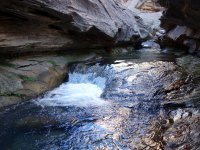
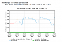
I don't know that you can make that direct comparison, since there are likely other drainages that funnel into the Escalante River, and external factors like irrigation diversion affect flow. I do have photos of the Death Hollow narrows and Escalante discharge data (under 5.0 CFS) from that day for a relative comparison.

I think this is the scrunchy section, where you have to crawl under (or over) the overhang to avoid the potholes.
DSC03525.JPG


I hiked it on 11 Nov 2017.
Screenshot 2019-05-21 at 7.59.32 PM.png
 
A group of 6 of us were down in Death Hollow this past Sunday May 19th - Tuesday May 21st.
Our plan was to hike from the Boulder airstrip, down Death Hollow to the Escalante River, and back out to Highway 12.

We hiked to an overhang camp spot a mile of two in with plans to hike down to the Escalante River the next day. Sunday night into Monday morning provided us with plenty of rain/snow overnight which lead to waterfalls spilling over the cliffs of Death Hollow. When we woke up on Monday morning we has discovered the river had grown easily a couple feet in depth, as well as widened it a couple feet.

We decided to try pushing on down Death Hollow but were disappointed to find chest deep water less than 1/2 mile past our camp site. Temperatures were in the low 50's and high 40's in the day, yet even with neoprene socks, we decided it would be best to either hike back out/find a spot closer to the hike out/ or just stay another night under the overhang (which we did).

Just being in the water waist deep for an hour or less was uncomfortable.

With all the rain and snow that was dumping North of us in Dixie National Forest, we decided to hike out our 3rd morning. While we hiked out yesterday we ran into 4 groups, totaling about 15 people heading down into Death Hollow. The clouds behind us looked very ominous, and it started snowing on us again right as we reached the parking lot.

It was unfortunate that we were unable to complete the trip, yet conditions were borderline hypothermic, and the weather did not look like it was getting better.

Also, we drove down to the Highway 12 Escalante River Trailhead to get our other shuttled car on the way back. We took a look at the Escalante River levels when we picked up the other car, and the river was running strong. Completely muddy, and roughly 15-20 feet wide. It would have been a bad idea if we had chosen to continue on with our original plan.

Not saying or hoping that these conditions would be present when you plan to go but watch the weather. This area has had nearly double the precipitation this Spring when compared to other years. We could not believe that there was snow falling in late May in the Escalante area, yet it is high elevation.

Let me know if you have any other questions or wanted info about the route. Best of luck!
 
Thanks for your report. I was planning on doing Death Hollow next week with a group as well. Might have to make alternate plans based on the forecast. Wading isn't a big deal, but when it's only 52 degrees as the high that could be trouble. Crazy water year!
 
Thanks a ton Mikjik86! I'll most likely go somewhere else (or cancel completely) instead; that sounds like a ton of water.
 
Last year, we loved the part of Boulder Mail Trail that was between Death Hollow and the town of Escalante (except the part coming into town, which we didn't do because we connected to the Escalante). If the short part of Death Hollow that's part of BMT is passable but you can't do the rest of Death Hollow to Escalante River, you might want to consider staying on BMT. The area around Mamie Creek and the spur to the Natural Bridge were great, and the large expanses of slickrock past Mamie were terrific.
 
The weekend weather down there is looking nice too, so @Janice's suggestion would probably make for a very nice trip.
 
Similar threads
Thread starter Title Forum Replies Date
Boognish Lower Death Hollow Narrows April 2018 Backpacking 17
Strawsome Lower Death Hollow at it's finest Backpacking 3
RyanP Lower Death Hollow, mid-April Trip Planning 8
BJett Part 3 - Tour de Canyon Country. Lower Escalante Loop Hiking & Camping 0
fiber Lower Grand Gulch Pour-off Trip Planning 9
slieb Lower Muddy Creek in Winter? Trip Planning 7
regehr water in lower muley twist? Trip Planning 0
regehr Lower Horseshoe Canyon and Big Spring Trip Planning 7
J Scrambles in the Lower Colorado River Corridor AZ/NV; Dec. 11-14, 2020 Hiking & Camping 5
Devin Ashby The Lower Gulch - Escalante (Seeking info on the route) Trip Planning 14
Stephanie B Sixteen Room Ruin and Lower Butler Wash Hiking & Camping 15
fossana Sheep Bridge/Lower JEM trail (Virgin, UT) Conservation Project General Discussion 5
T Dark canyon - lower blm portion with pack goats?? Canyoneering 2
pstm13 Texas Pass Cirque of Towers Lower Wind River Range August 2018 Trip Planning 7
Ross West Canyon quicksand (a/one want to go lower West/Face/Labyrinth August? Trip Planning 3
DiscGo Lower Watermaiden [Video] Hiking & Camping 5
Outdoors24 Overnight in Lower Spring Canyon Backpacking 5
Ravialdo Lower Muley Twist water situation? Trip Planning 13
Udink Lower Horseshoe Canyon Hiking & Camping 0
Kullaberg63 Lower Dirty Devil Backpacking 7
Jackson Lower Red Castle Lake Backpacking 4
scatman Lower and Midway Geyser Basins plus Buffalo Meadows - Yellowstone National Park - June 26, 2016 Backpacking 5
BJett Lower Escalante Trifecta - Davis Gulch to Fiftymile Creek Backpacking 8
BJett Lower Escalante Trifecta - Willow Gulch to Davis Gulch Backpacking 14
mattvogt7 Lower Escalante Packraft Loop Backpacking 12
Jackson Lower Spring Canyon in Winter Backpacking 14
Nick Floating lower Cataract into Glen Canyon Trip Planning 2
mattvogt7 Lower Cataract Canyon Loop Backpacking 16
Parma Lower Salmon River - Hammer Creek to Heller Bar On The Water 7
lostlandscapes Lower Red Castle Lake -- 6/13/15 Backpacking 19
IntrepidXJ The Lower San Juan River On The Water 8
IntrepidXJ Lower Grand Gulch Backpacking 5
toejam Lower Sisquoc Loop Backpacking 7
ram Crash Site/Lower Hades Canyon 2-15-15 Canyoneering 1
LarryBoy Water Sources in Lower Grand Gulch Trip Planning 15
Ben wind river range, elkhart park to lower jean lake Backpacking 13
Dave December in Lower Muley Twist Backpacking 20
Udink Lower Price River Hiking & Camping 8
westerner54 Lower Grand Gulch, Below the Narrows Backpacking 3
IntrepidXJ Lower Calf Creek Falls Hiking & Camping 5
Scott Chandler Chimney Rock-Lower Spring Canyon, Cap Reef NP Hiking & Camping 6
Nick Lower Black Box Trip Planning 0
BJett Lower Big Creek - Great Smoky Mountains National Park On The Water 2
Nick Lower Bells Canyon Hiking & Camping 3
Udink Lower San Rafael Hiking & Camping 4
Bill Lower Brimstone Gulch - Escalante Hiking & Camping 11
Cody Halls Creek Loop via Lower Muley and Red Slide Backpacking 16
slc_dan Lower-Lower Muley Twist 4/12/2013 Backpacking 14
Nick Lower Muley Twist vs. Upper Muley Twist Trip Planning 19
slc_dan Lower Salt Creek/Paul Bunyan's Potty Backpacking 11

Similar threads

Back
Top