Christian
Member
- Joined
- Jun 2, 2012
- Messages
- 161
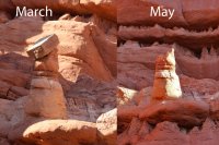
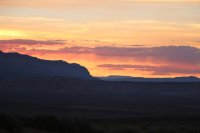
Late Thursday night, on the 9th, my friend Calvin and I left Salt Lake planning to camp at Little Egypt. I was there just over a month before, so I thought it would be very easy to drive back. However, it was a new moon that night so we ended up looking all over before ending up in Ticaboo to use the phone's gps and get to the place. This burned a ton of time so we didn't get to sleep until after sunrise. Fortunately, this allowed for some sunrise shots. I was surprised to see that a hoodoo that was fine in March had fallen over. It's hard to believe that something that's been there for thousands of years fell down between my two visits.


On Friday morning we went down to Bullfrog and turned onto the Burr Trail. Our first stop was Pedestal Alley. This is a great place! No one was there and there are tons of Pedestals to see. The terrain surrounding the area is cool and even has some narrows cut through the rock by the washes. The wildflowers were blooming in many varieties and there were some giant caterpillars crawling all over. This hike took a surprisingly long chunk of time, especially with all the photos we shot.


We headed back to the Burr Trail and started driving towards Upper Muley Twist Canyon in Capitol Reef. We got there as the sun was setting so we just went and hung out at the Strike Valley Overlook for sunset. I've long wanted to visit the overlook and an isolated storm moved over the valley with lightning bolts shooting down. I got lucky and captured this epic bolt!

Sunset to the west of Strike Valley v


Peek A Boo Arch by Upper Muley turn off v

We camped nearby and woke up early with the intention of hiking to Saddle Arch. Once we got there, I wanted to see if I couldn't find Trinity arch, so we just kept hiking. I learned when I arrived home that I'd already seen it much earlier from the 4x4 road into the canyon and just failed to realize that it was Trinity. Anyhow, we explored the narrows which were very interesting, then went over the bypass around them and ended up doing the whole 9 mile loop. It was really cool, especially the views of the Strike Valley form the Rim Route and the tilted red sandstone to the west. There are at least 7 arches that can be seen along the way, although almost all are inaccessible to up close views due to being on the aforementioned tilted sandstone. It's just flat out too steep to climb up to them.
Saddle Arch v

Huge Pano from inside an arch with an unknown name v

Unknown Arch v

Another Unknown v

Upper Muley Twist Narrows v


End of the loop, having just completed the scramble to the rim route, 4.5 miles to go v

Rim Route Views v

We got back from the hike just before nightfall and headed in to Escalante with the intention of going right to sleep in anticipation of going to Zebra and Tunnel Slot in the morning. However, the gleaming Milky Way overhead convinced us to shoot night shots in Devil's Garden until 4AM.


On Sunday, we hiked out to Zebra. On the way we saw this great lizard.

Zebra was full of waist deep water. There was a dead drowned rat stuck to the side of the canyon towards the middle, which was quite disgusting. The water had toads in it, I saw at least 3. We hung out in Zebra waiting for the sun to cross from one side to the other so as to shoot outside of the harsh light. I don't know if I believe all those shots that show Zebra as having orange and saturated blue light as I shot as the light was at peak reflection at all white balances and never got anything resembling what is so often seen online with the intense hyper saturated blues on one wall, but who knows…


We went to tunnel slot next, and it had water that was chest deep and much colder, but we ended up getting used to it and shooting photos in the water for a while. There are a lot of Moki Marbles on the other side of the tunnel in the drainage, but nowhere near as many as I've seen in pictures in other areas nearby Zebra and Tunnel. I couldn't find this area but I wish I could have, since I've wanted to see it.
Tunnel Slot v

The sandstone in Halfway Hollow where Zebra is located is very striped and cool, so I shot some pics of it on the way out.

After we finished this hike, we drove down to Devil's Garden again to shoot sunset. It was great.


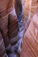
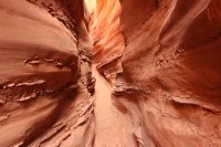
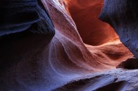
The next morning was our last day, so we went and did the Peek A Boo and Spooky Canyons. We also did some random other canyon that's right next to Peek A Boo. It's seemingly longer than the other two and it's probably deeper but never anywhere near as narrow or twisty as the other two. I thought Spooky was awesome, especially coming in from the top, since one of the first things you see is a cool arch. It's also extremely narrow for most of its length.
The random canyon by Peek A Boo v

Spooky Arch v

Spooky Log Jam

Peek A Boo Large Double Arch v ( only one of the arches in view, but the other is right next to it.)

Peek A Boo Arch Quite small, but a person can easily sit in the little pocket. v

Narrowest part of Peek A Boo, at the end v

Same arch as above, different angle v

Spooky passage v

Looking up to the sky in spooky from the very narrow depths v

Once we were done doing that, we were going to go see Sunset Arch. However, I decided to coerce my friend into taking a horrible cow road off towards 50 mile mountain and hiking a mile through trail-less sage brush to go check out these incredible hoodoos. They must be 100 or more feet tall.
As a last send off for the trip, I lost the leg to my brand new $200 tripod out there. I imagine it will be there for the rest of time as it came off up on a very steep hill in an area without any trails. I'm hoping to get it replaced by the company.
Anyway, from there it was straight back home to Salt Lake.
Featured image for home page:

On Friday morning we went down to Bullfrog and turned onto the Burr Trail. Our first stop was Pedestal Alley. This is a great place! No one was there and there are tons of Pedestals to see. The terrain surrounding the area is cool and even has some narrows cut through the rock by the washes. The wildflowers were blooming in many varieties and there were some giant caterpillars crawling all over. This hike took a surprisingly long chunk of time, especially with all the photos we shot.
We headed back to the Burr Trail and started driving towards Upper Muley Twist Canyon in Capitol Reef. We got there as the sun was setting so we just went and hung out at the Strike Valley Overlook for sunset. I've long wanted to visit the overlook and an isolated storm moved over the valley with lightning bolts shooting down. I got lucky and captured this epic bolt!
Sunset to the west of Strike Valley v
Peek A Boo Arch by Upper Muley turn off v
We camped nearby and woke up early with the intention of hiking to Saddle Arch. Once we got there, I wanted to see if I couldn't find Trinity arch, so we just kept hiking. I learned when I arrived home that I'd already seen it much earlier from the 4x4 road into the canyon and just failed to realize that it was Trinity. Anyhow, we explored the narrows which were very interesting, then went over the bypass around them and ended up doing the whole 9 mile loop. It was really cool, especially the views of the Strike Valley form the Rim Route and the tilted red sandstone to the west. There are at least 7 arches that can be seen along the way, although almost all are inaccessible to up close views due to being on the aforementioned tilted sandstone. It's just flat out too steep to climb up to them.
Saddle Arch v
Huge Pano from inside an arch with an unknown name v
Unknown Arch v
Another Unknown v
Upper Muley Twist Narrows v
End of the loop, having just completed the scramble to the rim route, 4.5 miles to go v
Rim Route Views v
We got back from the hike just before nightfall and headed in to Escalante with the intention of going right to sleep in anticipation of going to Zebra and Tunnel Slot in the morning. However, the gleaming Milky Way overhead convinced us to shoot night shots in Devil's Garden until 4AM.
On Sunday, we hiked out to Zebra. On the way we saw this great lizard.
Zebra was full of waist deep water. There was a dead drowned rat stuck to the side of the canyon towards the middle, which was quite disgusting. The water had toads in it, I saw at least 3. We hung out in Zebra waiting for the sun to cross from one side to the other so as to shoot outside of the harsh light. I don't know if I believe all those shots that show Zebra as having orange and saturated blue light as I shot as the light was at peak reflection at all white balances and never got anything resembling what is so often seen online with the intense hyper saturated blues on one wall, but who knows…
We went to tunnel slot next, and it had water that was chest deep and much colder, but we ended up getting used to it and shooting photos in the water for a while. There are a lot of Moki Marbles on the other side of the tunnel in the drainage, but nowhere near as many as I've seen in pictures in other areas nearby Zebra and Tunnel. I couldn't find this area but I wish I could have, since I've wanted to see it.
Tunnel Slot v
The sandstone in Halfway Hollow where Zebra is located is very striped and cool, so I shot some pics of it on the way out.
After we finished this hike, we drove down to Devil's Garden again to shoot sunset. It was great.
The next morning was our last day, so we went and did the Peek A Boo and Spooky Canyons. We also did some random other canyon that's right next to Peek A Boo. It's seemingly longer than the other two and it's probably deeper but never anywhere near as narrow or twisty as the other two. I thought Spooky was awesome, especially coming in from the top, since one of the first things you see is a cool arch. It's also extremely narrow for most of its length.
The random canyon by Peek A Boo v
Spooky Arch v
Spooky Log Jam
Peek A Boo Large Double Arch v ( only one of the arches in view, but the other is right next to it.)
Peek A Boo Arch Quite small, but a person can easily sit in the little pocket. v
Narrowest part of Peek A Boo, at the end v
Same arch as above, different angle v
Spooky passage v
Looking up to the sky in spooky from the very narrow depths v
Once we were done doing that, we were going to go see Sunset Arch. However, I decided to coerce my friend into taking a horrible cow road off towards 50 mile mountain and hiking a mile through trail-less sage brush to go check out these incredible hoodoos. They must be 100 or more feet tall.
As a last send off for the trip, I lost the leg to my brand new $200 tripod out there. I imagine it will be there for the rest of time as it came off up on a very steep hill in an area without any trails. I'm hoping to get it replaced by the company.
Anyway, from there it was straight back home to Salt Lake.
Featured image for home page: