Late Season Uintas Day Hike Ideas. Bear River to WFBF and Back?

Perry

Formerly Cuberant
.
Joined
Aug 8, 2016
Messages
2,072
I'm looking to get it a nice day hike in the Uintas on Saturday before the season is done. I considered heading into Allsop or Priord basins but thought that might be a bit long for a short October day. Also would like something a little less traveled for variety. While perusing the map in that area I saw the Bear River Smith Fork trail which runs east from the East Fork Bear River trail head to the West Fork Blacks Fork trail. Looks like that would be about 12 1/2 miles out and back with a couple of passes.

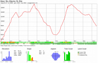
upload_2017-10-5_8-58-57.png

upload_2017-10-5_8-54-34.png

Has anyone been over that route? Anything interesting to see?
 
I can't imagine that trail would have very good scenery, probably mostly walking through trees. Have you considered Hell Hole Lake? Not many people head up there. Not sure on the distance, my guess is about 10 miles RT.
 
I can't imagine that trail would have very good scenery, probably mostly walking through trees. Have you considered Hell Hole Lake? Not many people head up there. Not sure on the distance, my guess is about 10 miles RT.

That looks like an option @andyjaggy . When you have gone into there did you go from MLH or the Christmas Meadows side?
 
That looks like an option @andyjaggy . When you have gone into there did you go from MLH or the Christmas Meadows side?

Most people go from MLH as the Christmas Meadows side is gated. There is some road walking involved either way.
 
I’m still curious about the Bear River Smith Fork Trail... anyone been on it?


Sent from my iPhone using Tapatalk
 
@Jen posted a trip report a while back where she used it to do a loop combining WFBF, Allsop and Priord. I don't recall how she described it in the report, but I know when we talked in person her review of that section involved a lot of expletives. It sounded awful. Don't do it.
 
@Jen posted a trip report a while back where she used it to do a loop combining WFBF, Allsop and Priord. I don't recall how she described it in the report, but I know when we talked in person her review of that section involved a lot of expletives. It sounded awful. Don't do it.

ROFL! I'm curious as to what were the problems? Do you recall?
 
I found @Jen's trip report. Here's what she had to say about that section...

... After a stop at the creekside to soak our feet and refill water we reached the Bear river trailhead and were pleased with our time, 10 miles out, thinking we were a third of the way there. Then we started up Deadman's pass. In the boiling sun. Ugh. The dry shells of beetle kill trees did nothing but make us feel like we were climbing into hell. We wished for a hail storm, a cloud, anything at all. It may only be 1500 ft of gain and not that a steep of an incline, but at the time it was extremely uncomfortable. You could see, however, the teenage aspens taking over the space left by the dead pines, and it was pretty interesting.

We collapsed at the top in the shade of a tree for a while, then discovered that the trail leading down to road 664 was non-existent. We headed cross-country towards the road where a few four wheelers and dune buggies passed us, unfortunately not with any room for extra passengers. A mile down the road it branched to the right towards a small lake. The main road continued on the Trail Creek Trail, but we headed south of the small peak, past the unnamed lake and thru a grassy clearing with a branch of what appears to be Mill creek running through it. We reloaded on water (it was so incredibly hot) and 13 miles into our day started up our fifth pass for the trip.

The elevation gain was small but there was almost no trail to be found. We bushwacked and crawled over trees until the top whre we found a well-established trail that (thankfully!) was clear with little deadfall, dumping us down into Cataract Basin and towards our trailhead. Our feet were aching and we were tired but getting into the shady side of a pass made all the difference. We no longer felt like we were dying and were able to practically jog down the clear, wide path. By the time we hit the West Fork Blacks Fork trailhead we were at almost 16.5 miles. Crossing the river to get to the register at the trailhead absolutely wrecked what was left of my feet, and I had to sit down for a while to talk my feet into continuing the last mile and a half to the car. Why in the world didn't we bring the 4wd vehicle? We were passed by a few riders on horseback and a teenager ripping around on a four wheeler but our attempts to hitch a ride were in vain. By the time we crossed the ford and were back to our Camry we were at 17.8 miles, much more than anticipated. My feet hurt.
 
I just noticed the proximity of A1 and Kletting peaks to Hell Hole Lake. What are they like to summit?


Sent from my iPhone using Tapatalk
 
I'm actually going to be heading up to A1 peak tomorrow. I've never been before, can anyone post a gps track of the route to get into the hell hole trailhead. I'm a little confused on how to navigate the oil road and which turn off I need to take from the MLH. The route is pretty obvious via Christmas Meadows looking at google earth, but it sounds like that is usually gated? I read to take the road just before the christmas meadows road to the stillwater campground, but from what I can see on google earth there is no road that connects from the stillwater campground to the oil road..... is it there and just doesn't show up well in the sat imagery?
 
Last edited:
I would think A-1 will be a pretty snowy trip tomorrow. I made it to the bench above Hell Hole before but decided against trying to summit from there because of the slope angle. TR: https://backcountrypost.com/threads/hell-hole-lake-august-2015.5538/

The road in from Christmas Meadows is always gated, as I understand. The oil company that drilled up there owns the road.
 
Last edited:
Yep the road was gated, and A1 was completely white with snow. We ended up going to Amethyst and back. Amethyst was not frozen, but it was solid snow about 1-1.5 miles before getting to the lake. As far as we could tell we were the only ones that had been there as there weren't any other footprints in the snow.
 
Similar threads
Thread starter Title Forum Replies Date
Perry Late Season Uintas Trips - What Do I Need to Know? General Discussion 15
Udink Invite Late-Season Uintas - Middle Basin Meet Up (Members Only) 9
Perry Late Season / Winter Backpacking Gear List General Discussion 13
G Escalante area 4-5 night backpack trip suggestions in late September. Loop if possible. Limit technical sections if any. Thanks! Backpacking 6
Janice San Juan Mtns - late June too early? Trip Planning 4
maisweh Better Late Than Never Noobs: Introduce yourself! 0
Parashakti Late July in Yellowstone Trip Planning 9
F Teton Wilderness, late July 2022 Trip Planning 6
C Utah Mountains in Late May Trip Planning 12
Nethos Santa Fe/ABQ/Durango Area- Mid Late June Trip Planning 11
The Trout Whisperer A Lil’ overnighter close to home Late Jan 2021 Backpacking 2
Jackson A Late Summer Summit Trip Backpacking 6
chebba87 Invite Looking for partner - Yellowstone late August Meet Up (Members Only) 1
Nethos Southern Utah - Late October & Early November 2020 Trip Planning 16
piper01 fall foliage in Colorado late September Trip Planning 6
U Just picked up a permit for Shelf Lake 2 nights in Mid/Late July. Any ideas for a day hike/summit from there? Trip Planning 0
Tarp Boy Uintas in late June? Trip Planning 10
regehr late 2019 road conditions in S Utah Trip Planning 55
kwc Late October Adirondack Paddling On The Water 6
TractorDoc Three Days at Mount Rainier in late July. Hiking & Camping 10
RyanP Texas Pass (Winds) in late July Trip Planning 23
RyanP 5-day route in Winds in late July? Trip Planning 0
TractorDoc Mount Rainier in Late July -- Day Hiking Meet Up (Members Only) 0
RyanP Lower Death Hollow next week (late May/early June), miscellaneous questions Trip Planning 16
ramblinman Yellowstone Dayhikes (late May) Trip Planning 1
10KFly Wind River Range in Late September Trip Planning 6
RyanP 3-day trip ideas (15-20 miles or so) for late May/early June with good water Trip Planning 9
dfcooper Late September trip in Glacier. Backpacking 2
N Grand Canyon and southern Utah in late November Trip Planning 3
fiber Invite Late March 3-4 day San Rafael Swell Backpacking Loop Meet Up (Members Only) 1
Wanderlust073 Utah late Oct/early Nov Trip Planning 7
Rello Wind River Range, WY - Late August Trip Planning 3
tomcat32 Late May suggestions for 100ish mile backpacking trip Trip Planning 1
A Escalante Route - Grand Canyon in late May 2017 Trip Planning 4
McKee80 Getting a late start ... Noobs: Introduce yourself! 2
oldie but goodie Never too late Noobs: Introduce yourself! 4
C day hikes in Canyonlands Needles in late November Trip Planning 19
outnabout Weather in the Winds late Sept Trip Planning 6
jkgear Table Mountain/Tetons Late Summer Trip Planning 12
Vegan.Hiker Wasatch/Uintas conditions late April/early May Trip Planning 6
b.stark A Very Late Beartooth Report Backpacking 14
JaseTheAce Southern Utah late June Trip Planning 4
Tres Westbrook Advice for Stillwater Canyon Canoe trip - late May. Trip Planning 6
katuah Southern Utah late March - early April Trip Planning 9
Eugene Suggestions for a late April 3-4 day backpack? Trip Planning 4
Matt Price A remote week-long trip, Late-may/Early June, Utah or the Southwest Trip Planning 34
Vegan.Hiker Southern UT, Late June Trip Planning 78
pbax Trip to SW VA in late Oct. suggestions welcomed Trip Planning 1
astark15 Late spring backpacking recommendations? Noobs: Introduce yourself! 7
mtjack Late Fall/winter sleeping bag Gear 2

Similar threads

Back
Top