- Joined
- May 5, 2012
- Messages
- 1,732
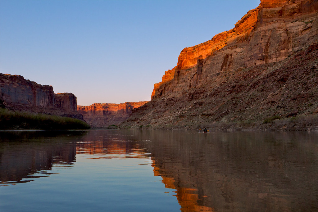
Superlatives fail to convey the sublimity of a slow slide into the depths of the Labyrinth. The tamed Green, displayed here as a docile ribbon loaded with sediment and cutting deep into a maze of sandstone, falls so gradually along its channel that one could be forgiven for mistaking the river for a long narrow pond. Even the good Major Powell, who saw the Green in its wild form before reclamation stunted its flows, remarked on its good character.
"There is an exquisite charm in our ride to-day down this beautiful canyon. It gradually grows deeper with every mile of travel; the walls are symmetrically curved and grandly arched, of a beautiful color, and reflected in the quiet waters in many places so as almost to deceive the eye and suggest to the beholder the thought that he is looking into profound depths."
—Maj. John Wesley Powell, The Exploration of the Colorado River and its Canyons
The Powell expedition would go on to even greater depths and more awe-inspiring canyons, leaving only a few short paragraphs about this particular stretch. Were it not for the uranium boom, much of Labyrinth would be completely untouched by motorized vehicles. That is not a slight on Labyrinth's unique beauties, however.

Labyrinth Canyon, named such by the Powell expedition, is the stretch of the Green River from roughly 95 to 55 river miles upstream from its confluence with the Colorado, né Grand. Its waters are generally placid and shallow. Simply getting to this stretch of river can be an adventure. Most people who float here put in at the town of Green River, where a state park provides a convenient launch point. The only problem with this rests with the unremarkable nature of the river above Labyrinth Canyon proper.
Those willing to put a little more effort into their arrangements can instead launch at Crystal Geyser or, more appropriately, Ruby Ranch. The latter is the last river access before Mineral Bottom, which rests at the end of Labyrinth Canyon and just north of the Canyonlands National Park border. Getting to both Ruby Ranch and Mineral Bottom requires some adventurous driving beyond the pavement.
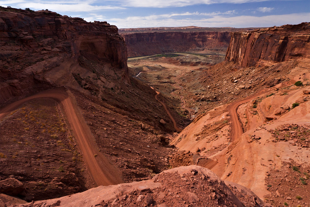
Mineral Bottom by ashergrey, on Flickr
My brother and I launched out early the morning of April 25th, 2013 in our two vehicles. Our boats, rented touring kayaks from REI, rested upside down on the top of my beater wagon. It would carry the boats to Ruby Ranch, where we'd drop them before driving down to Mineral Bottom. We left the wagon there, then drove back to Ruby Ranch together in the second vehicle in order to start the journey.
Unfortunately, the logistics that are so easily explained in just two sentences above proved more difficult when put into practice. The wagon had vomited coolant during my March trip to Coyote Gulch and did the same on the way to the put-in.

A little troubleshooting proved the engine had lost nearly all its coolant. We emptied bottle after bottle of water into the reservoir in order to get it running again.
At last we prepared to launch.

We were not on the water until about 6 p.m. due to the overheating delays. This proved to be a blessing, as we witnessed stunning light. The tamarisk-choked shores around the lowlands began to give way to short cliffs.
Cottonwood by ashergrey, on Flickr
I'd not paddled in years. The first strokes felt foreign but with each rotation of the blades my grip eased. Our narrow boats slid through the water as the sound of the ranch's pumps slurping at the salty, silty flow fell to silence behind us.
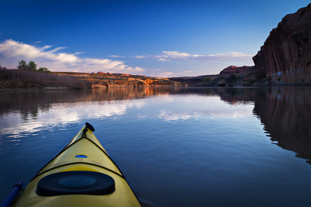
Below Ruby by ashergrey, on Flickr
Our paddles lapped hungrily at the waters as waterfowl honked their displeasure of our presence. Unlike the almost domesticated birds that choke municipal park ponds and golf courses around Salt Lake, these Canada Geese let us know we humans were the interlopers here.

Entering the Canyon by ashergrey, on Flickr
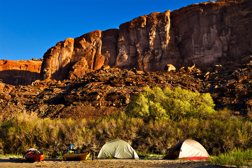
As the light waned our bows ran aground on a wide stretch of sand just upstream of Trin-Alcove Bend. We pitched our tents and built a fire of the plentiful driftwood.
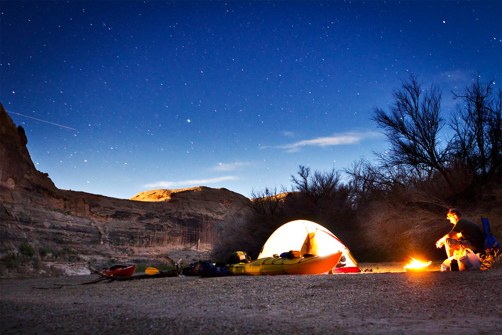
Sandbar Campsite by ashergrey, on Flickr
[PARSEHTML]<iframe src="http://www.mappingsupport.com/p/gmap4.php?q=http://dl.dropbox.com/u/3847512/GPS/Labyrinth_camp_1.kml&t=s" frameborder="0" marginheight="0" scrolling="no" width="800" height="800"></iframe><br><br>[/PARSEHTML]The sun didn't intrude on our sleep until late the next morning, thanks to the shadow-casting cliff across the river. We rose refreshed and eager to once again hit the water. Rounding the corner to Trin-Alcove Bend, we found it congested with people. The bend is a popular first-night destination according to all the guides I'd read. While I'm sure it provides fine accommodations, I couldn't help but feel grateful to have found our own space the night prior.

A few hours later we stopped to stretch our legs. Thousands of tadpoles scattered as our hulls breeched their stagnant pools at the mouth of Tenmile Canyon. The paths of dirt bikes scarred the mud, imprints of their large tire lugs reminding us that are few places left on earth where motors do not breech. My brother and I walked up the sandy wash until the mud on our feet dried and began to slough off in flakes. Then we donned proper footwear and wandered up the dry channel.
Tenmile Canyon Cottonwood by ashergrey, on Flickr
Midday sun beat down, unrelenting. Hydration bladders grew lighter with each thirsty sip. Our path through the sands tended toward the few spots where shade crossed the wash.
Cawley Arch by ashergrey, on Flickr

[PARSEHTML]<iframe src="http://www.mappingsupport.com/p/gmap4.php?q=http://dl.dropbox.com/u/3847512/GPS/Tenmile_Wash.kml&t=t4" frameborder="0" marginheight="0" scrolling="no" width="800" height="800"></iframe><br><br>[/PARSEHTML]Our next stop came where impetuous prosectors once clawed and blasted their way toward uranium: at the Hey Joe mine.

The adits here are marked on topographic maps, but the Utah Department of Natural Resources has waged a campaign against them. The discarded machinery and trash at Hey Joe bake in the sun, rusting away year after year. Tailings and fraying tires straddle the wash.
Nowhere Fast by ashergrey, on Flickr
But the holes themselves are closed for our own protection.

Like in Tenmile, the ground in Hey Joe is criss-crossed by the tracks of ATVs and motorbikes. Miners who decades past eschewed then-modern conveniences to chase fortunes here probably never expected that their successors would hunt here as well, not for uranium but for experience. The roads they carved for riches are now racecourses. The place where they lived in exile we now visit as recreation.
Hey Joe by ashergrey, on Flickr
Returning to our boats and to the welcome cool of the water, we pushed off toward our second campsite at the upper end of Bowknot Bend.
Drawn into the Labyrinth by ashergrey, on Flickr
Again we paddled into the dusk, watching the overgrown shorelines for an adequate place to land. This turned out to be a narrow strip of sand, surrounded by water. Our own little island.
Island Camp by ashergrey, on Flickr
[PARSEHTML]<iframe src="http://www.mappingsupport.com/p/gmap4.php?q=http://dl.dropbox.com/u/3847512/GPS/Labyrinth_camp_2.kml&t=s" frameborder="0" marginheight="0" scrolling="no" width="800" height="800"></iframe><br><br>[/PARSEHTML]The following morning I awoke early, watching the light strengthen against the cliffs. Skycall Satellite phone in hand, I dialed in to the KSL Outdoor show to chat with Russ and Tim.
[PARSEHTML]<audio controls><source src="http://dl.dropbox.com/u/3847512/Labyrinth_call.mp3">Your browser does not support HTML5.</audio>[/PARSEHTML]
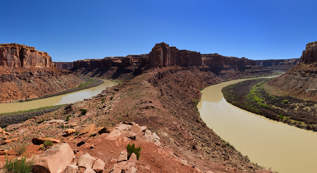
One of my goals of the trip was to climb to the saddle of Bowknot Bend, where it's possible to look down on either side of the knife-edge and see the languid river taking a leisurely detour around the castles of rock.
At the Bowknot by ashergrey, on Flickr
The route up from the river is not obvious. After landing, hikers find a steep but well-traveled path up a large section of rockfall.
Once on the saddle, the expansive view proves humbling. That intimate connection with the water one feels while gliding down the river evaporates. In its place grows a respect for the eons of geologic processes at play. One day the Green might cut through this narrow neck of land, leaving behind an abandoned meander. If it happens I will be long dead, along with everyone I've ever known. Along with, perhaps, the entire human race. Perspective.

I'd complained to my brother only a day earlier that despite my travels across the desert, I'd never stumbled across a snake. How fortuitous then that he'd spot this whip snake sunning itself up on the saddle. The pencil-necked reptile proved amazing in his tolerance of me and my bulky camera.

Snakey snakey by ashergrey, on Flickr
A river-runner registry also sits atop the saddle. We each signed it.

Unlike to many others who have floated down this river, we left no other marks. The walls here are littered with etchings and chalk. All that graffiti strikes me as crass. I hope that the same erosion that carved the canyon will in time erase all signs of human encroachment.
I yearn to believe in a greater ethos, in a commonality among peers in the out-of-doors. I'd like to believe that modern men are capable of moving through a space with the intent of leaving as little impact as possible. Yet I fear I am in the minority.
[PARSEHTML]<iframe src="http://www.mappingsupport.com/p/gmap4.php?q=http://dl.dropbox.com/u/3847512/GPS/Bowknot_ridge.kml&t=t4" frameborder="0" marginheight="0" scrolling="no" width="800" height="800"></iframe><br><br>[/PARSEHTML]Dauntless roads climb slopes across from the back side of the bowknot. They run up talus slopes to long-abandoned adits, more memories of the 1950s.
The strains of an acoustic guitar came into earshot as we rounded the bend at Twomile Canyon. A group of five canoes were beached there. The noise drew my ire, as I assumed someone had left a stereo blaring somewhere beyond the beach. Only as we passed did I realize the sound came from a man tucked up in the tamarisk, strumming and singing through the afternoon. I couldn't fault him.
We stopped for lunch at the mouth of Horseshoe Canyon. Heat had grown oppressive. I tried to sleep but found the incessant flies too much to bear. Before too long we pushed off again. In order to cool down, we scouted for spots where we could run our boats up on slightly submerged bars of sand and stop for a swim.

The Green pushes an incredible amount of sediment along its channel and, in its flow-managed state, it's often possible to stop on these deposits mid-channel.
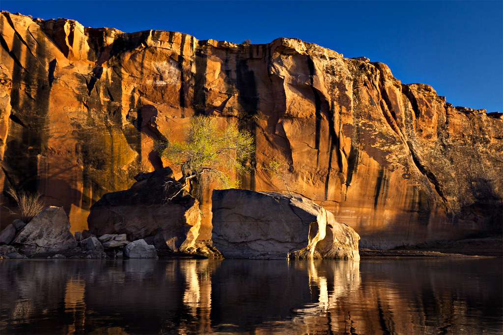
A bit farther down river, we stopped to see the Denis Julien inscription in Hell Roaring Canyon.

I shot the requisite photo of the inscription itself, but won't post it here. It's been so badly defaced by vandals that any awe it inspires gives rise to an equal amount of disdain. Luckily, the water awaited us after a brief nap in the shade of a giant boulder.
Looking back on Hell Roaring by ashergrey, on Flickr
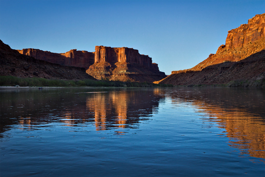
Mineral Bottom sits only a few short river miles below Hell Roaring Canyon. We paddled slowly, enjoying our last dusk on the water.
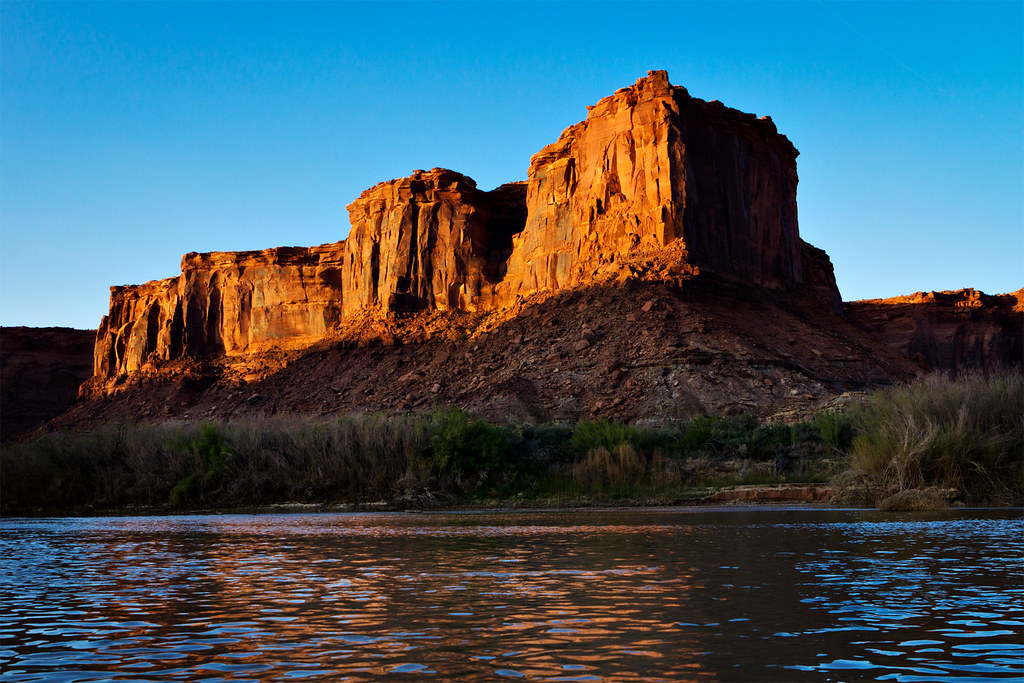
Castles of the Labyrinth by ashergrey, on Flickr
We'd intended to squat for a night at the boat ramp. Who would complain, as we were arriving late and planning to leave early the next morning? Our laden boats came out of the water. But as we started the process of unpacking and uncompressing from the long paddle, a party bus arrived. A van full of 20-to-30-something women came rumbling down the road from the switchbacks. It circled, throwing up a cloud of dust. It came to a stop and one of the women strode our direction.
She traded pleasantries before getting to business. She wanted to know if we were staying. We told her we were. She asked if we planned to camp at the day-use spot, the only place at Mineral Bottom with enough room for a comfortable stay. Again we answered in the affirmative. She wondered aloud how much we'd like to stay up listening to a group of 25 drunk women on the eve of a bachelorette party trip down Cataract Canyon.
We grit our teeth and prepared to dig in but, as the light waned and the obnoxious noise of their drunken revelry waxed, we relented. Under cover of darkness we departed Mineral Bottom to make the long drive back to Ruby Ranch.
Instead of a last evening of blissful peace along the shores of the Green, we suffered a breezy night up on the desert hardpan. In the morning we could hear a man with a camper parked 75 yards off in the distance mocking us for carrying boats to where there is no water. If he only knew.
[PARSEHTML]<iframe src="http://www.mappingsupport.com/p/gma...ox.com/u/3847512/GPS/Labyrinth_camp_3.kml&t=s" frameborder="0" marginheight="0" scrolling="no" width="800" height="800"></iframe><br><br>[/PARSEHTML]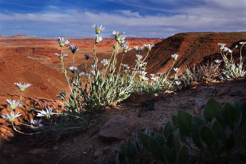
Silvery Townsendia by ashergrey, on Flickr
Featured image for home page:

"There is an exquisite charm in our ride to-day down this beautiful canyon. It gradually grows deeper with every mile of travel; the walls are symmetrically curved and grandly arched, of a beautiful color, and reflected in the quiet waters in many places so as almost to deceive the eye and suggest to the beholder the thought that he is looking into profound depths."
—Maj. John Wesley Powell, The Exploration of the Colorado River and its Canyons
The Powell expedition would go on to even greater depths and more awe-inspiring canyons, leaving only a few short paragraphs about this particular stretch. Were it not for the uranium boom, much of Labyrinth would be completely untouched by motorized vehicles. That is not a slight on Labyrinth's unique beauties, however.
Labyrinth Canyon, named such by the Powell expedition, is the stretch of the Green River from roughly 95 to 55 river miles upstream from its confluence with the Colorado, né Grand. Its waters are generally placid and shallow. Simply getting to this stretch of river can be an adventure. Most people who float here put in at the town of Green River, where a state park provides a convenient launch point. The only problem with this rests with the unremarkable nature of the river above Labyrinth Canyon proper.
Those willing to put a little more effort into their arrangements can instead launch at Crystal Geyser or, more appropriately, Ruby Ranch. The latter is the last river access before Mineral Bottom, which rests at the end of Labyrinth Canyon and just north of the Canyonlands National Park border. Getting to both Ruby Ranch and Mineral Bottom requires some adventurous driving beyond the pavement.
Mineral Bottom by ashergrey, on Flickr
My brother and I launched out early the morning of April 25th, 2013 in our two vehicles. Our boats, rented touring kayaks from REI, rested upside down on the top of my beater wagon. It would carry the boats to Ruby Ranch, where we'd drop them before driving down to Mineral Bottom. We left the wagon there, then drove back to Ruby Ranch together in the second vehicle in order to start the journey.
Unfortunately, the logistics that are so easily explained in just two sentences above proved more difficult when put into practice. The wagon had vomited coolant during my March trip to Coyote Gulch and did the same on the way to the put-in.
A little troubleshooting proved the engine had lost nearly all its coolant. We emptied bottle after bottle of water into the reservoir in order to get it running again.
At last we prepared to launch.
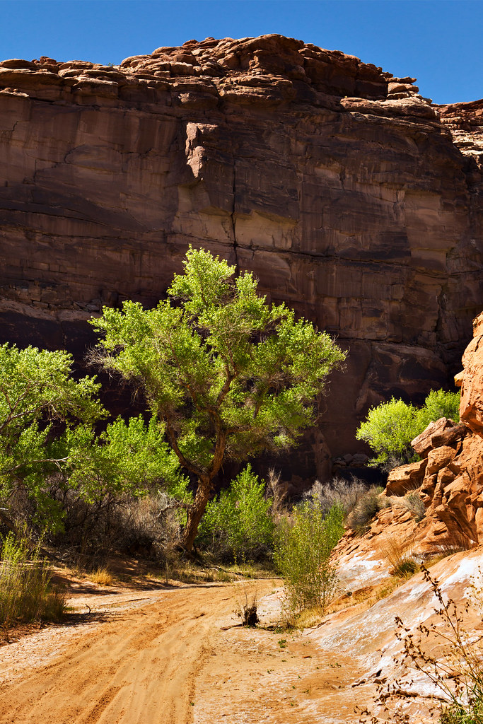
We were not on the water until about 6 p.m. due to the overheating delays. This proved to be a blessing, as we witnessed stunning light. The tamarisk-choked shores around the lowlands began to give way to short cliffs.
Cottonwood by ashergrey, on Flickr
I'd not paddled in years. The first strokes felt foreign but with each rotation of the blades my grip eased. Our narrow boats slid through the water as the sound of the ranch's pumps slurping at the salty, silty flow fell to silence behind us.
Below Ruby by ashergrey, on Flickr
Our paddles lapped hungrily at the waters as waterfowl honked their displeasure of our presence. Unlike the almost domesticated birds that choke municipal park ponds and golf courses around Salt Lake, these Canada Geese let us know we humans were the interlopers here.
Entering the Canyon by ashergrey, on Flickr
As the light waned our bows ran aground on a wide stretch of sand just upstream of Trin-Alcove Bend. We pitched our tents and built a fire of the plentiful driftwood.
Sandbar Campsite by ashergrey, on Flickr
[PARSEHTML]<iframe src="http://www.mappingsupport.com/p/gmap4.php?q=http://dl.dropbox.com/u/3847512/GPS/Labyrinth_camp_1.kml&t=s" frameborder="0" marginheight="0" scrolling="no" width="800" height="800"></iframe><br><br>[/PARSEHTML]The sun didn't intrude on our sleep until late the next morning, thanks to the shadow-casting cliff across the river. We rose refreshed and eager to once again hit the water. Rounding the corner to Trin-Alcove Bend, we found it congested with people. The bend is a popular first-night destination according to all the guides I'd read. While I'm sure it provides fine accommodations, I couldn't help but feel grateful to have found our own space the night prior.
A few hours later we stopped to stretch our legs. Thousands of tadpoles scattered as our hulls breeched their stagnant pools at the mouth of Tenmile Canyon. The paths of dirt bikes scarred the mud, imprints of their large tire lugs reminding us that are few places left on earth where motors do not breech. My brother and I walked up the sandy wash until the mud on our feet dried and began to slough off in flakes. Then we donned proper footwear and wandered up the dry channel.
Tenmile Canyon Cottonwood by ashergrey, on Flickr
Midday sun beat down, unrelenting. Hydration bladders grew lighter with each thirsty sip. Our path through the sands tended toward the few spots where shade crossed the wash.
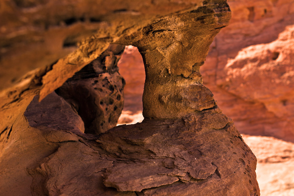
Cawley Arch by ashergrey, on Flickr
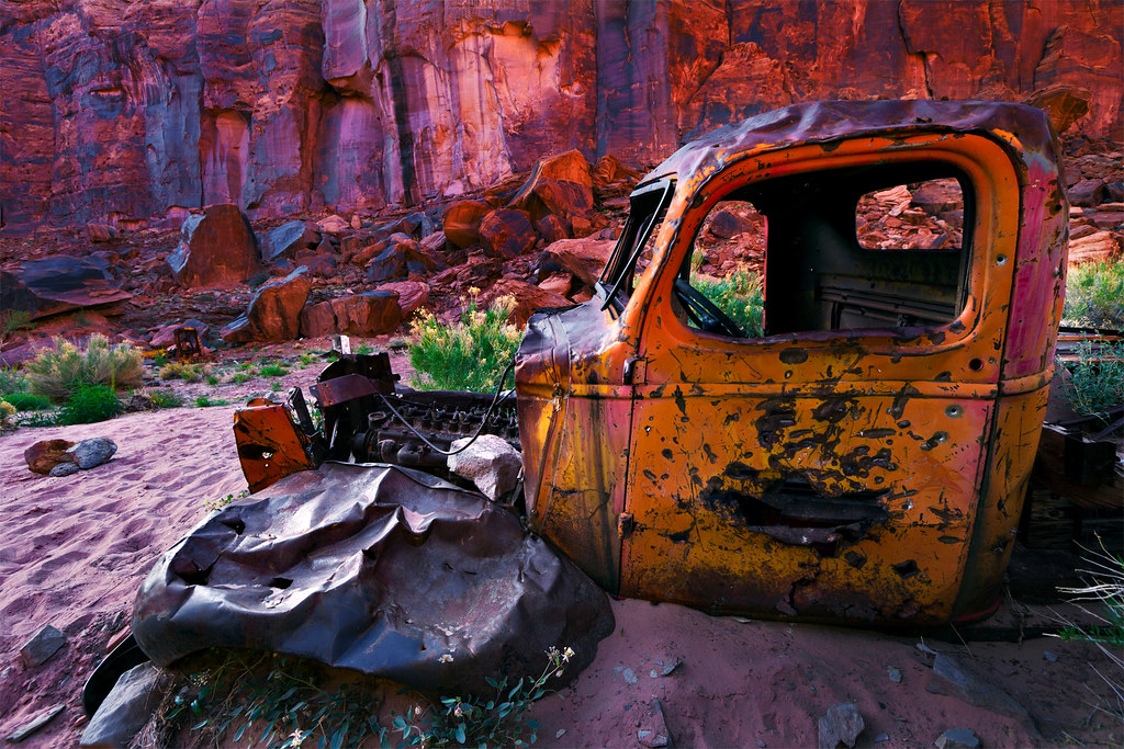
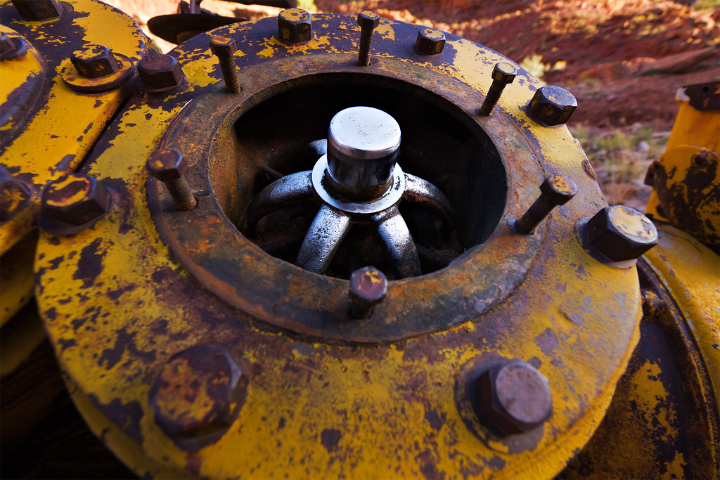
[PARSEHTML]<iframe src="http://www.mappingsupport.com/p/gmap4.php?q=http://dl.dropbox.com/u/3847512/GPS/Tenmile_Wash.kml&t=t4" frameborder="0" marginheight="0" scrolling="no" width="800" height="800"></iframe><br><br>[/PARSEHTML]Our next stop came where impetuous prosectors once clawed and blasted their way toward uranium: at the Hey Joe mine.
The adits here are marked on topographic maps, but the Utah Department of Natural Resources has waged a campaign against them. The discarded machinery and trash at Hey Joe bake in the sun, rusting away year after year. Tailings and fraying tires straddle the wash.
Nowhere Fast by ashergrey, on Flickr
But the holes themselves are closed for our own protection.
Like in Tenmile, the ground in Hey Joe is criss-crossed by the tracks of ATVs and motorbikes. Miners who decades past eschewed then-modern conveniences to chase fortunes here probably never expected that their successors would hunt here as well, not for uranium but for experience. The roads they carved for riches are now racecourses. The place where they lived in exile we now visit as recreation.
Hey Joe by ashergrey, on Flickr
Returning to our boats and to the welcome cool of the water, we pushed off toward our second campsite at the upper end of Bowknot Bend.
Drawn into the Labyrinth by ashergrey, on Flickr
Again we paddled into the dusk, watching the overgrown shorelines for an adequate place to land. This turned out to be a narrow strip of sand, surrounded by water. Our own little island.
Island Camp by ashergrey, on Flickr
[PARSEHTML]<iframe src="http://www.mappingsupport.com/p/gmap4.php?q=http://dl.dropbox.com/u/3847512/GPS/Labyrinth_camp_2.kml&t=s" frameborder="0" marginheight="0" scrolling="no" width="800" height="800"></iframe><br><br>[/PARSEHTML]The following morning I awoke early, watching the light strengthen against the cliffs. Skycall Satellite phone in hand, I dialed in to the KSL Outdoor show to chat with Russ and Tim.
[PARSEHTML]<audio controls><source src="http://dl.dropbox.com/u/3847512/Labyrinth_call.mp3">Your browser does not support HTML5.</audio>[/PARSEHTML]
One of my goals of the trip was to climb to the saddle of Bowknot Bend, where it's possible to look down on either side of the knife-edge and see the languid river taking a leisurely detour around the castles of rock.
At the Bowknot by ashergrey, on Flickr
The route up from the river is not obvious. After landing, hikers find a steep but well-traveled path up a large section of rockfall.
Once on the saddle, the expansive view proves humbling. That intimate connection with the water one feels while gliding down the river evaporates. In its place grows a respect for the eons of geologic processes at play. One day the Green might cut through this narrow neck of land, leaving behind an abandoned meander. If it happens I will be long dead, along with everyone I've ever known. Along with, perhaps, the entire human race. Perspective.
I'd complained to my brother only a day earlier that despite my travels across the desert, I'd never stumbled across a snake. How fortuitous then that he'd spot this whip snake sunning itself up on the saddle. The pencil-necked reptile proved amazing in his tolerance of me and my bulky camera.
Snakey snakey by ashergrey, on Flickr
A river-runner registry also sits atop the saddle. We each signed it.
Unlike to many others who have floated down this river, we left no other marks. The walls here are littered with etchings and chalk. All that graffiti strikes me as crass. I hope that the same erosion that carved the canyon will in time erase all signs of human encroachment.
I yearn to believe in a greater ethos, in a commonality among peers in the out-of-doors. I'd like to believe that modern men are capable of moving through a space with the intent of leaving as little impact as possible. Yet I fear I am in the minority.
[PARSEHTML]<iframe src="http://www.mappingsupport.com/p/gmap4.php?q=http://dl.dropbox.com/u/3847512/GPS/Bowknot_ridge.kml&t=t4" frameborder="0" marginheight="0" scrolling="no" width="800" height="800"></iframe><br><br>[/PARSEHTML]Dauntless roads climb slopes across from the back side of the bowknot. They run up talus slopes to long-abandoned adits, more memories of the 1950s.
The strains of an acoustic guitar came into earshot as we rounded the bend at Twomile Canyon. A group of five canoes were beached there. The noise drew my ire, as I assumed someone had left a stereo blaring somewhere beyond the beach. Only as we passed did I realize the sound came from a man tucked up in the tamarisk, strumming and singing through the afternoon. I couldn't fault him.
We stopped for lunch at the mouth of Horseshoe Canyon. Heat had grown oppressive. I tried to sleep but found the incessant flies too much to bear. Before too long we pushed off again. In order to cool down, we scouted for spots where we could run our boats up on slightly submerged bars of sand and stop for a swim.
The Green pushes an incredible amount of sediment along its channel and, in its flow-managed state, it's often possible to stop on these deposits mid-channel.
A bit farther down river, we stopped to see the Denis Julien inscription in Hell Roaring Canyon.
I shot the requisite photo of the inscription itself, but won't post it here. It's been so badly defaced by vandals that any awe it inspires gives rise to an equal amount of disdain. Luckily, the water awaited us after a brief nap in the shade of a giant boulder.
Looking back on Hell Roaring by ashergrey, on Flickr
Mineral Bottom sits only a few short river miles below Hell Roaring Canyon. We paddled slowly, enjoying our last dusk on the water.
Castles of the Labyrinth by ashergrey, on Flickr
We'd intended to squat for a night at the boat ramp. Who would complain, as we were arriving late and planning to leave early the next morning? Our laden boats came out of the water. But as we started the process of unpacking and uncompressing from the long paddle, a party bus arrived. A van full of 20-to-30-something women came rumbling down the road from the switchbacks. It circled, throwing up a cloud of dust. It came to a stop and one of the women strode our direction.
She traded pleasantries before getting to business. She wanted to know if we were staying. We told her we were. She asked if we planned to camp at the day-use spot, the only place at Mineral Bottom with enough room for a comfortable stay. Again we answered in the affirmative. She wondered aloud how much we'd like to stay up listening to a group of 25 drunk women on the eve of a bachelorette party trip down Cataract Canyon.
We grit our teeth and prepared to dig in but, as the light waned and the obnoxious noise of their drunken revelry waxed, we relented. Under cover of darkness we departed Mineral Bottom to make the long drive back to Ruby Ranch.
Instead of a last evening of blissful peace along the shores of the Green, we suffered a breezy night up on the desert hardpan. In the morning we could hear a man with a camper parked 75 yards off in the distance mocking us for carrying boats to where there is no water. If he only knew.
[PARSEHTML]<iframe src="http://www.mappingsupport.com/p/gma...ox.com/u/3847512/GPS/Labyrinth_camp_3.kml&t=s" frameborder="0" marginheight="0" scrolling="no" width="800" height="800"></iframe><br><br>[/PARSEHTML]
Silvery Townsendia by ashergrey, on Flickr
Featured image for home page: