SUPERBLOOM
We got off to another slow start on Saturday morning. I worked on organizing our gear and loading my pack while Christy picked up breakfast at Rise Coffee. We eventually made it out of the hotel and drove to the Green Mountain Trailhead at the confluence of North Leigh Creek and Tin Cup Creek. The area features some primitive campsites, a field for horse trailer parking, and a rougher road to the actual trailhead. Christy dropped me and my pack off there at noon. Christy and Jackson headed for Rexburg, Idaho, where they planned to spend the afternoon at public pool / waterpark. We planned to meet back at one of the campsites near the trailhead that evening.
My first challenge was crossing Tin Cup Creek. It looked like rock hopping might be possible, but the attempt would probably result in waterlogged boots. I waded across in an old pair of running shoes and then stashed them behind a log.
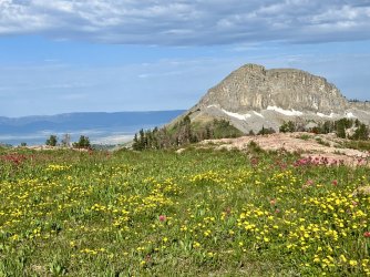
The hike started with a steep climb, but it eased up after a short distance. I hiked through the woods for less than a mile before reaching a junction in a small meadow. There, the Andy Stone Trail continues ahead. That sounded mildly intriguing, but my route turned east and began climbing switchbacks. Before long I popped out into an immense meadow. The meadow extends all the way up the mountain, and it was absolutely covered in golden flowers. It was literally flowers for miles – as far as I could see. It was one of the most astonishing things I’ve ever seen.

Wildflower meadow

Looking into Idaho

Endless switchbacks ensued. The climb was never-ending, but the views improved as I climbed. The upper half of the climb featured views across northeastern Idaho. I eventually reached the top of the ridge, revealing views to the east towards the Tetons. An isolated thunderstorm rumbled to the south, but it kept its distance.

Storm to the south
I followed the ridge south to a notch below Green Mountain. A steep descent to the east followed. Most of it wasn’t bad, but there was one short stretch with some scree and bad footing. At the bottom I continued following the trail south, below the cliffs of Green Mountain. I followed a bench below the mountain but well above North Leigh Creek.

Along the ridge below Green Mountain

The trail heading down

Columbine

Below Green Mountain

The lowest of the Green Lakes, where we camped
I set up camp there and started the hike back. The climb back up the ridge was steep but short. The hike down was a breeze, literally. It was extremely windy, making photography difficult.


Scenery on the hike back down
I finally reached the bottom and waded the creek to the trailhead. Then I walked the road back down to the campsite we had spotted on the drive in. I found Christy and Jackson there, with camp already set up. They’d had a great day in Rexburg, enjoying the pool. We had dinner and then squeezed into the smaller tent for the night.
The next morning we packed up and drove back to the trailhead. The hike back up the ridge was a lot tougher with Jackson on my back. I really struggled, and Jackson had a full blown meltdown part of the way up. By the time we reached the top of the ridge I needed a break. I got Jackson out and let him walk the next stretch. We continued to the notch below Green Mountain, where we stopped for a rest.

The next day was pretty, too

Christy on the trail

I think I took this same photo six times (each time I passed by here)

Jackson exploring

The never-ending meadow


View west from the top of the ridge

Christy heading towards Green Mountain

Glorious

View east

View northeast
Christy hung out with Jackson there while I scampered up to the summit of Green Mountain. The view from the summit is incredible. The best part was looking down at lower Green Lake, where we were camped, with rugged peaks beyond. I enjoyed the view for a few minutes before heading back to rejoin the family.

View north from Green Mountain

Green Mountain just ahead

The lowest Green Lake below Green Mountain. I can almost see our tent.

Incredible flowers
We hiked together from there to the campsite. When we arrived I noticed that the adjacent campsite was no longer occupied. We spent the rest of the afternoon enjoying the lake, before returning to the campsite for the evening.

Jackson pointing out the trail ahead

Christy and Jackson

Jackson on the trail

Jackson heading for the lake
LITTLE BY LITTLE
Christy gave me a free day on Monday. My goal for the day was to climb Littles Peak – an obscure mountain on the Teton Crest a few miles southeast of our campsite. When I first planned this trip, I spent a lot of time studying the map for dayhike destinations from our basecamp. Research online didn’t turn up much. Ultimately Littles Peak was the one that excited me the most, but it looked like a destination that would be too difficult with Jackson. Fortunately, Christy was willing to stay back with Jackson so that I could do it solo.
I set the alarm for 6am, but Jackson was on top of me when I woke. I was nap trapped for 20 minutes before I managed to escape. It was a little after 7 when I left the campsite. I crossed the outlet stream and returned to the junction where the trails to Green Lakes and Granite Basin split. I picked up the trail to Granite Basin, climbing high above our campsite at Lower Green Lake. I reached treeline and hiked below Green Mountain, passing an impressive variety of wildflowers.

Columbines

Lewis Flax

Green Mountain

Parry's Primrose by a small stream

Nearing treeline

Looking back at Green Mountain

Impressive cliffs

Tarns above the Green Lakes basin

Another look back
Before long I reached a junction with the Teton Crest North Trail. I continued ahead, climbing to a vague ridge separating the Green Lakes basin and the Granite Lakes basin. The wildflowers went from impressive to astonishing once again. I left the trail in this area, heading southeast towards the Teton Crest.

Grand Teton peekaboo

Another incredible wildflower meadow

Littles Peak ahead
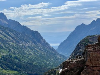
I reached a minor gap on the crest without difficulty. I arrived at a point looking directly down Leigh Canyon to Leigh Lake. I followed the crest south from there, arriving at the base of Littles Peak a few minutes later. Following the north ridge looked like the obvious route on the map. In reality, the north ridge is a steep talus pile. I figured that any other route would be just as bad, or worse, so I started up.

View down Leigh Canyon

I started the climb here

Which led me here
Later, I discovered that I was wrong. There is a slightly better route a little farther southwest. That was a lot easier to see when I was descending.
The climb was slow and tedious, but I made steady progress. I stayed close to the east edge of the ridge, resulting in frequent views of Maidenform Peak, Thor Peak, Leigh Canyon, and a pretty alpine tarn far below. There were also numerous views back towards Green Lakes, Green Mountain, Granite Basin, and northeastern Idaho.

View of Leigh Canyon

One of the lakes in Granite Basin

Maidenform Peak

Leigh Canyon

Alpine tarn far below

Maidenform Peak

This is why you should never stand on a snow cornice

View north

Leigh Canyon
The grade eased a bit before the summit. At the top, I was greeted with an incredible view of the peaks at the heart of the Tetons under a pitch black sky. It was only 10am – apparently the afternoon thunderstorms were getting a head start. The hostile sky made for an incredibly stark scene featuring hundreds of shades of black, white, and grey.

The Tetons from Littles Peak

Summit marker

Stormy Tetons
The southwest ridge extending from the summit was equally intriguing. It consisted entirely of white rocks, possibly quartz? The view in that direction was almost as exciting as the main event to the southeast.

The southwest ridge
It was early, but I ended up eating lunch on the summit because I didn’t want to leave. I lingered for a long time – probably too long, considering that storms were already raging over the highest peaks to the southeast. Eventually I headed down though. It was a little easier to pick a good route going down the talus, since I could see where I was headed. Once at the base, I took the most direct route back to camp. I knew that Christy would be entertaining Jackson the entire time that I was gone, so I was eager to get back and give her a break.

Marmot

Lower Green Lake

Lower Green Lake
When I returned they were napping in Christy’s hammock. It wasn’t long before they woke up though. I also discovered that a large group of teenagers was now camping nearby. Although there were a bunch of them, they never bothered us. Later that afternoon, Christy swam across the lower Green Lake. Storms were threatening, and it even started to rain while she was on her way back. We all hurried back to the tent, where we huddled until the storm passed.

Jackson playing

Christy going for a swim

Jackson
We got a huge surprise that evening. I was chasing Jackson around the campsite when our friend Spencer appeared. Wait, what? I knew that Spencer was passing through the area on his way to southern Utah. The last I’d heard, he was camping on the east side of the Tetons near Jackson. I had told Spencer where we were going to be camping, but I definitely did not expect him to show up there!

Spencer with me and Jackson
We hung out for a couple of hours. Even better, Spencer brought me a much-appreciated beer. It was an Old Faithful Ale from Grand Teton Brewing Company, and it was delicious. Unfortunately, Spencer didn’t bring camping gear with him, and there was no way to squeeze him into our tent. He could have slept in Christy’s hammock, but we didn’t have a tarp, and storms were threatening again.
He ended up heading out around dusk, prepared to hike the 5 miles by headlamp. We had several rounds of thunderstorms that night, but it was a couple of days later before we found out that he made it back to the car safely.
POPSICLE
Tuesday was the best day of the trip. My plan was a family hike to another stretch of the Teton Crest, north of Littles Peak. The goal was a small lake that sits just east of the divide, just inside Grand Teton National Park. It is really more of a tarn, and it is unnamed on my maps. I found one reference to it online. That individual referred to it as Popsicle Lake. It was an intriguing destination, and it looked like it wouldn’t be terribly difficult to get to.
I started with some early morning photos from the lakeshore.

Morning at the lake
After breakfast we hiked through the rest of the Green Lakes Basin. The climb up to the middle lake had some tough stretches, but Jackson did great. We passed a waterfall draining the lake, but the trail is a good distance from it.
The middle lake may be the most scenic, as there are interesting cliffs and lots of exposed bedrock on the far side.

The Middle Lake

Cliffs across the lake
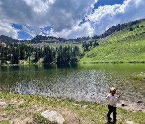
After a short break we continued up the trail past the upper lake. We continued on to a junction with the Teton Crest North Trail, which we followed south towards Granite Basin. We passed through some meadows full of Paintbrush before leaving the trail to drop down to another small lake. We had lunch there before resuming our hike.Cliffs across the lake

Upper Green Lake

Tarn

Paintbrush along the Teton Crest North Trail

Looking back over the Green Lakes Basin
We reached the junction that I had passed the previous day and continued towards Granite Basin. This was a stout climb, and I carried Jackson for the first time that day. We ended up leaving the trail at about the same place as I had left it the previous day. This time though, instead of heading southeast, we went northeast. Before long we reached a small snowfield. I got Jackson out of the pack so he could play. He hiked the rest of the way to Popsicle Lake from there, off trail.

Christy and Jackson

Jackson playing in the snow
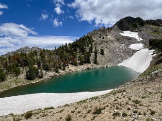
We reached the Teton Crest at the south end of Popsicle Lake. The lake is just a big tarn that is nearly surrounded by snowfields. We circled around to the north side so that we could walk down to the lakeshore.

Popsicle Lake

Popsicle Lake

Jackson at Popsicle Lake

Popsicle Lake from the other side
Christy and Jackson took a long break there while I explored around. I hiked around the east side of the lake, before exploring farther north. While I was wondering around, I stumbled upon a large, locked bear box. I’m guessing that it contains supplies for park rangers and search and rescue operations.

We hiked north along the Teton crest, and views of Maidenform Peak, Cleaver Peak, and the South Fork of Moran Canyon opened up. Before long, the biggest peaks at the heart of the range came into view.


Views from the Teton Crest

Snow on the Teton Crest

Christy on the crest

View from the crest

Christy taking in the view

View from the crest

Parting view

Upper Green Lake

Marmots
On the way down the trail below the middle lake, I asked Jackson if he wanted to see the waterfall. He did! Christy was ready to return to camp, so she went ahead while we veered off trail. I held Jackson’s hand as we walked through some brush to the base of a wide, mossy waterfall just below the middle lake. It’s a really cool spot, and it completely fails to show up on the topo map. Jackson played there for a some time while I attempted photos in the sunshine. Then we continued downstream. After a short stretch along the creek we angled away to regain the trail. We followed that back to the campsite, where Christy was waiting for us.

Waterfall below Middle Green Lake

Jackson doing a silly walk
We had some light rain and a some thunder that night. We also had deer or elk stomping around outside the tent well after midnight. They were loud enough to wake me up, but I managed to fall back asleep eventually.
DOUBLED UP
We packed up and headed out the next morning. My original plan was to hike out with the family and then return for the gear. That would’ve made for a long day. We came up with a different plan over breakfast.
After eating, Christy loaded up her pack and I carried Jackson. We all hiked back up to the top of the ridge together. I stashed Jackson’s empty pack there. Christy and Jackson continued on from there. We were hoping that he could hike down the final 4 miles on his own. If not, they would stop and wait for me.

Christy leaving Green Lake

Hiking out


Parting view

Final view of Lower Green Lake

Shooting Stars
I was just starting the climb up the ridge when I encountered a group with pack llamas. I stepped aside and watched them go by. I really wish I’d been with Jackson when they passed them. I’ll bet he really got a thrill from them.

Taboot, taboot
When I reached the top of the ridge I stopped to figure out some logistics. I decided to try attaching Jackson’s pack to the back of my pack. I could barely lift the combination of packs, and nearly fell over getting it on my back. The pack was empty, but even empty it is probably 10 pounds. The bigger issue is that it is bulky and the weight was too far back. Once I had it on I was able to walk, but it was extremely uncomfortable. I knew that taking breaks would be very difficult, as I might not be able to get it back on again.

Parting view of Green Mountain

Let's have dinner down there somewhere

At that point I had about a mile to go. I wasn’t interested in trying to hoist it again, so I tried a different technique for the final stretch. I unclipped Jackson’s pack but wore mine like normal. Then I tried throwing Jackson’s pack over my right shoulder. That approach was also awkward and painful. I alternated sides repeatedly, and eventually made my way down to Tin Cup Creek. Christy was watching Jackson play in the creek there. They had been there for a while – I didn’t come close to catching up to them. That was because Jackson hiked the whole 4 miles down the mountain!
My old running shoes were still there, so I wore them to wade back across the creek for the final time. We loaded up the car and prepared to leave, but the car wouldn’t start. The battery was dead. Luckily, we had recently purchased a portable battery with jumper cables attached to it. We hadn’t tried it out, but now was the time. It worked great – the car started right away. That was a relief, because we had no cell service and there wasn’t anyone else around.

I'm glad we had this!
We drove back to Driggs for dinner. I was inclined to go back to Citizen 33, but it was packed and we didn’t want to wait. We ended up at O’Rourkes, which was faster but just ok. From there we drove to the Teton Canyon Campground, where we had a campsite reserved. We arrived at dusk, set up camp, and went straight to bed.
") Before leaving town for extended dispersed camping, I always ask: " Is the portable jump starter charged up? The answer is always: "yes honey, you always ask that and yes, I charged it"
Before leaving town for extended dispersed camping, I always ask: " Is the portable jump starter charged up? The answer is always: "yes honey, you always ask that and yes, I charged it" 