LOST AND FOUND
Wednesday was my first solo hike of the trip. Christy wanted to take a day off, and I needed a break from carrying Jackson. She decided to take him into DuBois to take a shower, visit a playground, and run some errands. I was happy with that plan, since she was willing to drop me off and pick me back up near Togwotee Pass. My plan was to hike to the summit of Breccia Peak. I had originally hoped to hike both Mount Sublette and Breccia Peak on the same day, but that had been too much for us the previous day. In hindsight, if we had started earlier we probably could have combined them by following their connecting ridge.
It was late morning when Christy dropped me off. I started on the same trail that we followed the previous day, but I reached a fork after a couple of minutes. This time I stayed left and followed a good trail through woods and meadows. I crossed several small streams early on. The trail fizzled out in a huge meadow just before a pass. I continued up through tall flowers and grass to the divide. From there I continued north to the northeast ridge of Breccia Peak. I met a group there on their way down. They mentioned that they had seen a bear near the trail on their way up.

Breccia Peak

Approaching the pass

Breccia Peak

Looking north into the Teton Wilderness

Mount Sublette on the next ridge

Breccia Peak

Does this qualify as an arch?

Mount Sublette and the Wind River Range

Looking north

The Tetons from the summit

Lost Lake, with the Tetons in the distance
He headed down after only a few minutes, and I followed a few minutes later. However, I had to decide what to do next. Heading directly back to the road didn’t make sense, because that would leave me waiting for Christy for a couple of hours. I considered following the ridge southeast to Mount Sublette and following the trail down from there. My other option was to check out a potential waterfall on Clear Creek at around 9,700’. It was a spot I had marked while studying topo maps in preparation for my 2022 backpacking trip. It is a long way from any trail, and I hadn’t heard anything about a waterfall there, but it looked pretty obvious on the map. After a brief contemplation, I decided that I had to check it out.
I descended Breccia Peak by the same route, down the northeast ridge. However, instead of turning back towards the pass, I continued down east towards a tributary of Clear Creek. I was back at treeline when I saw a cannister of bear spray in the grass in front of me. My first thought was, “God, I hope I don’t find a mauled corpse”. Fortunately, I only saw the bear spray. My second thought was, “How did that get there?”. I was a long way from the nearest trail or established route. The only reason to be there would be to hike from Breccia Peak to Clear Creek (or from Clear Creek to Breccia Peak). How many people do that?
I picked up the bear spray and noted that it had a couple of years before it expired. I put it in my pack – it wouldn’t hurt to have an extra.

Forget-me-nots
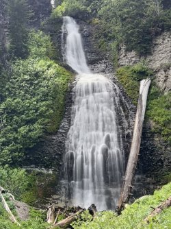
I crossed the tributary before it dropped down into a deep gully. I paralleled the tributary for a while, before working my way up onto the ridge to the east. I followed the ridge down until I was below the cliffs that form the waterfall. Then I cut back to the southeast, through a jungle of bushes, fallen trees, and wildflowers. Before long I reached the brink of the canyon and hunted for a good way down. It was very steep, but passable. I descended from one tree to the next. Then I turned back up the canyon towards the base of the waterfall. This required steep sidehilling high above the creek. Some of the footing was sketchy, but then I got my first glimpse of the waterfall. It is a beauty! That motivated me to find a way to the base of it.

Thick bushwhacking
I didn’t go all the way to the bottom, but I did reach a spot just downstream with a great view of it. I stopped there to enjoy it, but there wasn’t a good place to relax on the steep hillside.

Waterfall on Clear Creek
Before long I began contemplating my route out of there. I considered heading south up the opposite ridge. That would eventually take me to Mount Sublette and a good trail down the other side. However, that ridge is brutally steep, and it was hard to guess how long it would take. Did I have time for all of that? Probably not without keeping my wife and son waiting for me on the side of the road for an extended period of time.

Silky Phacelia

Waterfall upstream

Forget me nots

Paintbrush

Paintbrush and Silky Phacelia

Columbines
Ultimately I climbed back up by the same route. However, at the top of the escarpment I headed upstream past the brink of the falls. The hike upstream was surprisingly easy. Farther upstream I found a small 2-level waterfall. That was a nice little bonus. Shortly after that I climbed out of the creek and headed west and then southwest up a gully. Before long I reached a minor pass and found a trail heading down the other side. It looked like it would take me down to the trail I had hiked on the way in.
I decided to try it, and it paid off. It took me right back to the main trail, which I followed back to the road. I arrived just before Christy and Jackson returned, so the timing was nearly perfect.
On the way back we stopped to check out Brooks Lake Creek Falls. We parked just outside the campground, which looked pleasant and quiet. I did the short walk to several overlooks of the waterfall. Brooks Lake Creek Falls is impressive, but the view from the rim of the canyon isn’t ideal. The topo suggests that it should be possible to descend down into the canyon farther downstream. Hiking back up the creek would be tough, but that’s something that I’ll need to consider for a future trip.

The Pinnacles

Brooks Lake Creek Falls

Brooks Lake Creek Falls and The Pinnacles

Columbine
On the walk back I focused on the views of the Pinnacles and the numerous columbines along the trail. From there we headed back to camp. At the entrance we paid for an extra night, as we had decided to extend our stay. We had decided that the 4-day backpacking trip into the Wind River Range was too ambitious. Instead, we would do another dayhike before heading back to Lander. The revised plan called for a 3-day backpacking trip to Silas Canyon, starting on Saturday.
BONUS DAY
Thursday was a mellow day. We only had to drive a couple of miles to reach the trailhead for our hike. Our goal was Bonneville Pass and the cliffs above Dundee Meadows. We found the trailhead parking area empty. I was surprised. Like many of the destinations in the immediate area, the scenery is spectacular. Yet, it seems like very few people are aware of it. I guess most folks are in too big of a hurry to get to Yellowstone or the Tetons and drive right by.
A few minutes of walking brought us to Bonneville Creek. The water was low enough that Christy was able to rock hop. I decided against trying to do that while carrying Jackson, so I did an easy wade in my water shoes. I changed into my boots on the far side and left my shoes there for the crossing on the way back.

Paintbrush and Lupine

Monument Plant

Jules Bowl
After a couple of miles and a couple of hours we rock hopped the creek and entered a huge meadow. That meadow extends all the way to Bonneville Pass. That final half mile has very gentle terrain, but lots of mud in early summer. When I had passed through here in late July of 2022 there had been a wildflower super bloom. There was no super bloom on this visit, but the flowers were still really impressive.

Bonneville Pass

Bonneville Pass

Lunch break

I was going to make this my Facebook profile pic, but my wife won't let me
We decided to skip it. I did hike out to the northeast end of the pass to see if I could get a better view of Dundee Meadows. That eluded me, but the view back to the southwest was fantastic from there.

Bonneville Pass

The Pinnacles from Bonneville Pass

Jackson

Bonneville Pass

There he goes again
We hiked back by the same route. Storms threatened, but all of them missed us. We returned to the campground for one more pleasant evening before heading to bed.

Hiking out

Columbine

Hiking out

Snowy Phlox

Hiking out

The Pinnacles at the Brooks Lake outlet

Brooks Lake
It was almost an hour later when I noticed some nice color on the cliffs. I hurried back down to the lakeshore for more photos. The color was nice, but not spectacular. I’m guessing that the big mountains to the east mute the alpenglow.

Brooks Lake at sunrise

Cool clouds

The Pinnacles at first light

Brooks Lake

Brooks Lake