Island Park / Yellowstone Private Airport Development

Bob

Trailmaster
Joined
Mar 3, 2013
Messages
4,369
If anyone is interested in this. This is what we are curently fighting here in Island Park, Idaho. This about 13 miles west of the Yellowstone Park boundary. The runway is being built to accomodate small Jets (no commercial). And homes would be mostly megamansions with runway access. There is a Utube link to watch the commision meeting on Monday the 18th. This is a preliminary , this is what we want to do meeting. There will have to be another for public comment.... which I would like everyone to write in against the project when it occurs...
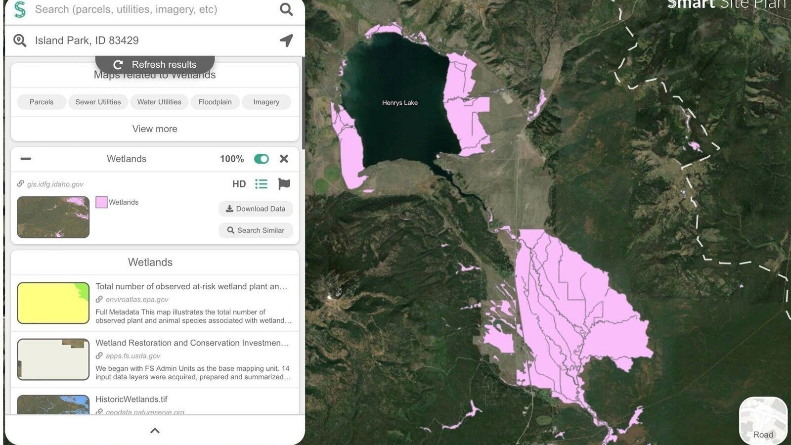
It borders a large tract that the nature conservancy owns, Is adjacent to wetlands, very near to the headwaters of the Henrys Fork of the Snake River, and is a area integral to the GYE. All we need is more people density, pollution, noise......
There is also a Motel wanting to build on the highway next to this property. For some reason developers are now thinking Island Park could be the stirring of another Jackson.

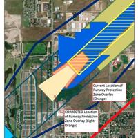
The preview we have received from the county.

For those wanting to listen to the presentation this is the YouTube link
https://bit.ly/3l0BkXG You will be able to view the meeting once it has started Monday, March 18th about 6 p.m.

Private Airfield is discussion added to P&Z agenda for Monday night​

THIS AFTERNOON FREMONT COUNTY PLANNING AND BUILDING DEPARTMENT NOTIFIED INVOLVED PROPERTY OWNERS OF ISLAND PARK OF AN ADDITIONAL INFORMATION DISCUSSION ADDED TO THE NEW BUSINESS AGENDA FOR THE FREMONT COUNTY PLANNING AND ZONING COMMISSION MEETING FOR MONDAY, MARCH 18 AT 6 P.M. AT 125 NORTH BRIDGE ST. ST. ANTHONY.​

The addition is added after the previously scheduled presentation by Leanne Yancey.
Planning & Zoning Commission Meeting 1. Call to Order, Welcome, conflicts in agenda, ex-parte communications. 2. Approval of Minutes: 2.1. None 3. New Business: 3.1 Leanne Yancey – Concerns about proposed land use changes and rezoning relevant to the Henry’s Lake Flats in Island Park 3.2 Doug Button – pre-application discussion with P&Z about potential private airfield development near Island Park. 3.3 Final Plat – Fair Dinkum (#24-015) – Action Item 4. Short Plats: 4.1 Baum Hossiner Pond Properties (#23-086) 4.2 Red Z Inc (#23-033) 5. Public Hearings: 5.1. Appeal: Donald Anderson and others, appealing Bullfrog Subdivision (#24-012) – Action Item 5.2. Zone Change- Dell J Barney – (#24-017) – Action Item 5.3. Comprehensive Plan Amendment – Dell J Barney (#24-018) – Action Item 5.4. Zone Change-Dell J Barney – (#24-019) – Action Item 6. Other Business: 5.1- Discuss comprehensive plan policies (Time Permitting) – Action Item

Island Air Park Narrative- Fremont County Sketch Plan
The subject property is a 431-acre parcel located in Island Park, Idaho. The property is located approximately 6,400 feet above sea level with the approximate center of the project located at 44.53865671 degrees, -111.32315652 degrees in decimal degrees. (Figure 1; aerial photo). The property is owned by ImperialInvestments, a Montana Limited liability Company, but is in the process of being transferred into the Island Air Park Limited Liability Company, an Idaho LLC, owned by Kevin and Douglas Button. The property was purchased in 2022 after an initial wetlands assessment was conducted in November of 2021 with a strong indication that the majority of the property were not regulated wetlands as defined by the US Army Corp of Engineers, but would require a complete Aquatic Resources Delineation Report such that the Buttons could obtain Section 404 permit(s) if activities impacted regulated areas that could not be avoided .This study was conducted in July of 2021,with the results submitted to the Army Corps of Engineers in December of that year.
In summary, of the 431-acre property, only 27.72 acres were determined wetlands and the remaining 403.28acres were not regulated. These studies were conducted by Kagel Environmental, one of the premier environmental engineering firms in the United States. As a result of a precedent case heard by the United States Supreme Court involving wetlands, our study was put in a holding pattern until last fall when we were given a favorable review by the Army Core of Engineers.
The property was purchased in 2021 with the express purpose of placing a private runway with a small number of private hangar homes, and private hangars on either side of the runway. The current zoning density allows for 120 homes or lots on a parcel this size, without community water and sewer and 150 with the bonus. It was never the vision for this property to create a dense population of dwellings, most of which, in the current regulatory environment, would inevitably become short term rentals. Our preference was to instill a sense of openness and privacy by limiting lot size to a minimum of 1.77 acres and rising to 1O lots of 22-65 acres+ parcels. (Figure 2 -subdivision plat) A runway located in the center travelling South to North of approximately 5200 feet in length would be accessed by taxi ways, or directly from residences.
Access to the development will be via two private access roads off of Highway 20. One at the very South edge of the property and the other in the North half of the property frontage on Hwy 20, approximately halfway between the shared property line with the Island Park Cemetery and the North property line shared with the State of Idaho 450 acre parcel. Both accesses would be Idaho State Transportation compliant with deceleration lanes approved by IDT. (Figure 3 - Entrance lanes).
Traditional placement of home fronts typically face major transportation arteries, but in this development, they will face the rear or Easterly direction. This will have the effect of limiting the visual impact of movement in the development. Added to this will be the placement of fir trees inside the property line adjacent to Hwy 20 but placed in a common area or 20-foot-wide open space controlled by the association. Trees will be placed such that a wall of trees will be visible from the highway in five to ten years. Trees will be maintained by the HOA.
The local FAA office in Helena MT approved the FAA7480 from with no restrictions noted and approval was granted on June 12, 2023 (the County was given a copy). The 5200-foot runway will be hard surfaced and maintained by the HOA. The property is bounded on the North by 450 acres of State of Idaho land, and on the South by 150 acres of State of Idaho land. In both directions, the nearest other property, that is not State land, is 2600 feet or one half of a mile away. All aircraft will be hanged at night or securely fastened to the ground. Runway access will be restricted to owners or lessors of property of the HOA. Courtesy access for emergency situations are being evaluated for such organizations as LifeFlight, Law Enforcement Agencies, and Firefighting Agencies, but no agreements or decisions have been made at this time.
The majority of the Eastern edge of the property line will be dedicated open space along the North to South boundary with future plans to provide environmentally sensitive walking paths constructed- of environmentally friendly materials and equipped with occasional benches as well as monitored and bearproof waste receptacles. The possibility of having days open to the public are under consideration, as well as the possibility of constructing a youth fishing pond with specific public access days.
There are 674 Airparks in the Continental United States and 176 of them are private. There are sixteen airparks in Idaho alone. It is our intention to make the Island Airpark one of the premier developments of its kind in the State and an asset to the community; by limiting the number of homes allowed on 431 acres of prime development land; by establishing and promoting environmentally sound protocols in the management of the community; by striving to protect the groundwater and promoting the sense of community among its owners and guests.

For those wanting to listen to the presentation this is the YouTube link
https://bit.ly/3l0BkXG You will be able to view the meeting once it has started Monday, March 18th about 6 p.m.
 
Mostly to make access convenient for the the mega-wealthy. :mad: Looks like they got OK from the Army Core of Engineers and got around the wetlands restrictions. All the right phrases like "environmentally friendly materials". County probably thinking - good, more tax income. Be happy to send a note against.
 
Nobody should be allowed to develop their private property as they see fit. It should always be put up to a public vote, and private landowners should just eff off.
 
Not that I think these change dot org things do any good.... here is a link for one up here.

 
Nobody should be allowed to develop their private property as they see fit. It should always be put up to a public vote, and private landowners should just eff off.
Respectfully, that's a bad-faith argument and the sardonic tone is completely unwarranted. I'd expect better from a generally respectful and thoughtful place like BCP, and from a long-time/valued member like yourself.

I think just about everybody except for the farthest-left fringe thinks that people should, in general, be able to develop their own property as they see fit. Where it gets tricky is that the impacts of an airport (noise, overhead traffic) inevitably spill over property lines and affect neighboring public/private lands. In such case, wouldn't a community conversation be warranted before proceeding? The whole idea behind having local/small-scale government is so these kinds of things can be negotiated. What if a nearby landowner can't sleep because jets roar overhead at 2am every morning? Wouldn't that at minimum impact his property value were he to sell in the future?

I have no view into whether this particular development is appropriate or not, but I am certain that we can't arrive at the right answer with a simple appeal to either side's ideology (e.g. without actually considering the facts of the case). And I'm even more confident that a sarcastic, dismissive tone toward people we disagree with does absolutely nothing to heal the fracture lines that exist in our society.
 
First off...I believe a landowner should be able to use his property as you want ...providing its within ordinances and laws and youre not infringing on other property owners.
And I believe development is a necessary evil, but a airstrip with house is for a weathly, playground type.. not the general population.
The developer has stated he bought (in 2022) this stricty to build a fly in development. He has owned it for no other reason, so its not like he had a interest in land ownership here. Money is the only driver in this case. Island Park will never be a Sun Valley or Jackson .....there is not the draw, the Park is it and that is really W Yellowstone. There are no fancy, restaurants, bars, boutiques, no ski areas. It is wildlife, forest oriented.

Henrys Fork flats is on the Nature Concervancy's protect list. They have already purchased about 1500 ac in the area. (not that I like conservation groups much) The flats comprise marshlands with dry land mixed, state Federal and private mixed. It is also the headwaters of the Snake (Henrys Fork) It has been historically grazing land. It is about 12 miles to the Park boundary. Even tho we are not talking about a commercial airport, The airstrip would put planes flying directly over the existing Island Park center, circling patterns would put planes over an even larger area of residential. There is a State airstrip about 4 miles away, the jetport in W Yellowstone and a airstrip in Ashton about 30 miles away. There are propsed 10 lots of 20ac or more (can you say megamansions) and 9 lots of 5 ac and 10 lots of 2 ac.

People can have a differing opinion.... thats a right and and a good one.
 
There is a State airstrip about 4 miles away, the jetport in W Yellowstone and a airstrip in Ashton about 30 miles away.
Those facts alone should be enough to deny permission for another airfield, especially if the state airfield can handle private jets. I did not see this included in the petition, though what they've done seems reasonable.

Not sure what the outcome of the Mar 15 meeting was but hope there's a coordinated effort with money behind it to oppose this. Developers put a lot of money into legalizing what they have to do. A university near me took 5 years to build a stadium with mega-lights adjacent to wetlands and a popular state park. Residents fought it (traffic, wetlands, lights, noise, loss of property value...) but the university had too much money to get what they wanted.
 
Respectfully, that's a bad-faith argument and the sardonic tone is completely unwarranted. I'd expect better from a generally respectful and thoughtful place like BCP, and from a long-time/valued member like yourself.

I think just about everybody except for the farthest-left fringe thinks that people should, in general, be able to develop their own property as they see fit.
:lol: Call me far-left, because I took that comment literally when I first read it. I'd rather associate with someone like that than someone that thinks buying land gives them some inherent right to impact their neighbors however they see fit.

There are lots of grey areas when it comes to land use/development and normally reasonable arguments on either side, but this project is a particularly egregious example of a mentality I have no patience for.

We all agree that there are lots of things more important than money, so it's a pretty lazy argument to say, "Well, they have more money, so let them do whatever they want."

I think you misinterpreted me too. I'm saying the exact opposite of "Well, they have more money, so let them do whatever they want."

Do you believe both of these?

1) Land ownership should give the owner a certain degree of control over how the land is used.
2) That right is not absolute. Building codes, environmental regulations, and the permitting processes can and should restrict certain activities.

If so, we are in agreement. :D
 
Yes.... But I'd add you should not do things to infringe on other property owners.... Like putting a shop in residential. Or in this case creating noise pollution/visual pollution of aircraft in landing patterns over houses. Now if you build your house near a existing airstrip.... That's different. Of course this could addressed in codes. Property in question up here needs a rezone to commercial for the airstrip...so that's a complete change in what it was.
 
I think you misinterpreted me too. I'm saying the exact opposite of "Well, they have more money, so let them do whatever they want."

Do you believe both of these?

1) Land ownership should give the owner a certain degree of control over how the land is used.
2) That right is not absolute. Building codes, environmental regulations, and the permitting processes can and should restrict certain activities.

If so, we are in agreement. :D
Total agreement. Might have worded it badly, but was directing that towards the same mentality you were "calling out".

Just meant I'm more likely to get along w/ the hypothetical person against any private property rights than the hypothetical person for absolute private property rights. (Edited to add: - though they're probably both pretty insufferable. :lol:)
 
Last edited:
What happened with the airport? I heard it was approved despite a lot of resistance against it.
 
Nope .. haven't had a public hearing on it yet
 
County Public Zoning Meeting July 22.

Sign Petition if you wish. https://chng.it/BTwbXhsyVg

I know these are just feel good stuff but it does show people dont want this development.

If you feel like email, time is short, like Today, 7/16 is last day:

We asked a well respected Idaho land use attorney to give us some talking points/messages relating to the best challenges to use to fight the two proposed developments on the Henry’s Lake Flats. Below are her recommendations on key talking points for letters and testimony at the July 22 public hearing. Please feel free to share this with others concerned about this issue.

If you have not sent a letter to the Fremont County officials by Tuesday, July 16.
Send to:
P&B@co.Fremont.ID.us
Tcluff@co.Fremont.ID.us
BSimmons@co.Fremont.ID.us
Skamachi@co.Fremont.ID.us
Rhill@co.Fremont.ID.us
Bdance@co.Fremont.ID.us

Here is whats going on:

I should add that the below information represents our best understanding of these proposals and the relevant regulatory documents and associated factors at this time. If anyone has or is able to develop additional insights or differing understandings, please share with the group!


HLE Inc. (airpark) proposals (Comprehensive Plan Map Amendment (#24-050) and Zone Change (#24-051)) on approximately 432 acres in the Island Park area (Parcel #RP14N43E130000):

  • The proposal to redesignate this property from Rural to Industrial is not consistent with many of the Fremont Co. Comprehensive Plan’s most foundational policies and goals:
  • To avoid piecemeal plan and zoning amendments, the Comprehensive Plan’s Policy 3 seeks to ensure an adaptive evolution of Plan direction through an inclusive planning process and regular Plan (and Code) reviews. This proposal appears to depend upon a “spot-zoning” approach that fails to reference documented shortcomings in the existing Plan, a need to deviate from established guidance, or the result of a recent programmatic review of the Plan or Code by the Planning and Zoning Commission.
  • Policy 8 directs the County to “direct development away from naturally hazardous areas or, where feasible, require site planning or construction techniques to mitigate the hazard.” The associated Goal is to “protect, maintain, and enhance the natural assets of Fremont County that contribute to the quality of life of the residents of the County and protect critical areas of the County. Encourage a stewardship ethic of land water and the conservation of resources.” The majority of the Property contains Freshwater Emergent Wetlands as mapped by the U.S. Fish and Wildlife Service, with implications regarding both construction hazards and the natural assets of the county.
  • Policy 10 directs the County to “maintain, protect and enhance water resources in the County. Fremont County recognizes that clean, plentiful water resources are vital for the county’s agricultural and recreational economies and will use its development code to maintain and protect water resources.” Furthermore, Policy 10 directs the County to protect water quality and require development to “demonstrate an adequate water supply.” Communications between the applicant and the County indicate that the developer does not currently have water rights to supply this development. In addition, the area’s sewer treatment systems are at capacity, and there are no current plans to expand capacity. The water resources in this area are interconnected and dependent on sufficient wastewater management.
  • Policy 11 recognizes “that fish and wildlife are a cornerstone element of Fremont County’s economy, image, heritage and reputation as an international recreational destination” that depend on “abundant open space, clean water, and healthy ecosystems with intact fish and wildlife resources and habitat.” This proposal would directly eliminate hundreds of acres of habitat and is likely to degrade the quality of surrounding open space, waterways, and ecosystems through disturbance and pollution.
  • Goal 12 declares the County’s intention to concentrate development in “suitable areas including existing population centers to ensure adequate public facilities” as well as to maintain rural character. The proposed application is inconsistent with this direction as it encourages residential sprawl, without adequate water and sewer facilities, and diminishes the rural character of the area.
  • Policy 13 encourages the County to “prohibit industrial uses that could have a negative impact on environmental quality and the attractions of the area.” A 5,200 foot long air strip, large enough to accommodate a wide array of private jet aircraft as well as small engine planes, is likely to result in countless bird strikes and noise impacts on migratory birds, exhaust pollution, habitat loss (due to construction), and habitat abandonment (due to disturbance) within and beyond the boundaries of the proposed development. Policy 13 states that County policy is to “prevent the creation of nuisances and require that new development blend compatibly with its surroundings.” Low-flying jet traffic over northern Island Park as well as Henrys Flat is highly likely to be viewed as both a nuisance and incompatibly blending with the surrounding area.
  • Policy 14 declares the County’s intention to concentrate development on suitable sites and avoid critical areas, the latter including “wetlands, stream and lakeshore corridors, steep slopes, wildlife habitat and corridors, and visually sensitive areas”. Policy 14 further seeks to preserve the area’s rural character. This proposal is incompatible with this guidance, as the property:
  • contains abundant mapped wetlands,
  • lies within an area identified as a high priority in the Idaho Wetland Conservation Prioritization Plan by Idaho Dept. of Fish and Game,
  • lies within a Conservation Focal Area in Idaho’s State Wildlife Action Plan,
  • lies within an Area of Critical Conservation Concern (for lands managed by the BLM),
  • lies within the Greater Yellowstone Ecosystem grizzly bear Priority Conservation Area and Demographic Monitoring Area,
  • provides critical habitat for migratory birds and highly-visible wildlife including pronghorn antelope, deer, and elk, and
  • is demonstrably rural. Even those areas zoned as Industrial immediately south of the property consist almost entirely of clustered residential and neighborhood commercial and resort uses.
  • The proposal to redesignate this property from Rural to Industrial is not consistent with Fremont Co. Code:
  • Though the sketch plan indicates a fly-in residential community is the intended use, single-family residential use is not allowed in the proposed M-1 designation. It is unclear from the application materials if the applicant is intending to split this lot to accommodate multiple zones, but the County noticed this application as a rezone for all 432 acres. As it is currently indicated by the notice for this public meeting, rezoning to M-1 would not allow the development to proceed in line with the sketch plan. This creates uncertainty as to the actual uses planned here.
  • The property’s inherent characteristics do not appear to align appropriately with the County’s intention for M-1 lands. The Fremont County development code states that M-1 zone locations “should be relatively flat and free of natural hazards such as flooding or unstable soil.” Since the Property is located within critical wetlands as described above, M-1 is not a suitable zone for the Property.
  • Rezoning this property does not meet the standard under the Fremont County Development Code of being consistent with the Comprehensive Plan. As detailed above, the Comprehensive Plan’s policies are not aligned with this rezone and the proposed use, and it is not in the public interest to redesignate this property to Industrial.
  • The proposal to redesignate this property from Rural to Industrial is not in the public interest:
  • The County’s vision described in its Comprehensive Plan speaks to citizens’ strong sense of place and appreciation for open spaces and natural places. It recognizes “that maintaining and enhancing wildlife habitat is key to sustaining [fish and wildlife]. Land use planning results in the right type of growth for the county including open spaces through clustering, wildlife friendly development that allows for animal movement across the landscape, and setbacks, appropriate densities, and other mitigations in critical areas.” Despite a few accommodating design elements, authorizing development of this type, at this site, and at this scale appears to run counter to that vision.
  • The economy of this area of Fremont Co. depends upon recreation and tourism income from fish and wildlife. The Henrys Flat area consists of serene, rural open space surrounded by pristine and widely popular public lands. The rural nature of the area attracts visitors looking to enjoy natural recreational opportunities like fishing, hunting, wildlife-watching, and hiking. Those activities create broad economic benefits for the County, including tax revenue, and are themselves a public good for Fremont County citizens. Those qualities are what drove Fremont County to designate the area that includes the Property as Rural.
  • The Plan defines “rural character” as “a quality of life based upon traditional rural landscapes, activities, lifestyles, and aesthetic values.” In turn, the Rural Base District zoning designation is intended to “provide for the continued use of agricultural lands, rangelands, and wildlife management areas within the County; to limit development of hazardous areas including, but not limited to, fault lines, landslides, subsidence, shallow soils, steep slopes, unstable slopes, flooding, and seeps; and to allow a limited number of uses with excessive space requirements or buffering needs on nonprime agricultural lands.” The Comprehensive Plan indicates an intention to direct development towards populated areas, rather than continue to erode rural areas with development. Breaking up large areas of open space to accommodate sprawling residential development and intensive air traffic would significantly disrupt the rural nature of the area, making it less attractive to visitors and transferring a public good to benefit a wealthy few. This does not meet the standard of providing a public benefit as required by Fremont County Code for an application to amend the Comprehensive Plan.


Ensign Hospitality (hotel) proposal (Class II Permit (#24-063) on approximately 60 acres in the Island Park area (Parcel #RP14N43E135401)):

  • The project is not allowed in the Rural Base zone:
  • The proposed Project was noticed for the July 22 hearing as “guest lodge/hotel.” However, “Guest Lodge/Hotel” is not a recognized use under Fremont County Code. “Hotel” is defined as “The traditional commercial lodging use, in which guests rent out separate rooms within a larger structure. Includes ‘motel,’ etc. A hotel is a place of business. a) Typically the staff is available, on-site, 24hrs. b) Usually clearly commercial in character. c) May include other associated uses and service. d) A youth hostel, while different in some respects from a conventional hotel would still be treated as a hotel under this ordinance. e) A B&B with more than six bedrooms is a hotel under this ordinance.” A “guest lodge” is not a defined use in Fremont County Code, but the definition of “Lodge” refers to “Resort,” which in turn is described as “a broad term that includes more remote recreation uses or destinations such as “lodge,” “retreat,” “youth camp,” “dude ranch,” and so on. Resorts are typically reviewed and approved as an all-inclusive Conditional Use permit where all of the buildings, uses, and activities that will fall under the umbrella of the resort will be described and reviewed together.” The Project is a large 132-unit commercial lodge and is properly considered either a “hotel” or a “resort,” neither of which are allowed uses in the Rural Base zone according to the use table in section 4.13.010(f). Since the Project is not an allowed use in the Rural Base zone, the application cannot properly be processed as a Class II permit but instead appears to require a Rezone application.
  • The project is inconsistent with the objectives of the Rural Base zone:
  • Fremont Count Code § 4.12.010 specifically states that the Rural Base zone “is not intended to accommodate non-agricultural development.” The zone also includes numerous open space, agricultural, and nature conservation objectives, including:
  1. Promote the public health, safety, and welfare of the people of Fremont County by encouraging the protection of important agricultural and open lands; to ensure the important environmental features of the state and Fremont County are protected and enhanced; and to protect fish, wildlife, and recreation resources, consistent with the purposes of the Local Land Use Planning Act (Idaho Code section 67-6501 et seq., as amended).
  2. To conserve and enhance the cultural significance and character of open rural and scenic non-urban landscapes; to provide for agricultural and rangeland uses consistent with the conservation of the environmental and landscape values of the area; to allow the development of agricultural industries and agriculture service establishments; and to protect agricultural and rangeland uses and wildlife management areas from undue adverse impacts from adjacent development.
  3. Implement the Fremont County comprehensive plan goal to protect important agricultural land and to maximize opportunities for agricultural activities and an agricultural lifestyle in areas designated as Rural on the Comprehensive Plan Preferred Land Use Map.
  4. To protect and enhance the natural environment and natural processes for their historic, archaeological and scientific interest, landscape, faunal habitat and cultural values; to protect and enhance natural resources and biodiversity in the area.
Development of a large commercial 132-unit hotel is inconsistent with these Code objectives and the Project is therefore inconsistent with Fremont County Code.
  • The project is inconsistent with the Fremont Co. Comprehensive Plan:
  • Policy 8 directs the County to “direct development away from naturally hazardous areas or, where feasible, require site planning or construction techniques to mitigate the hazard.” The associated Goal is to “protect, maintain, and enhance the natural assets of Fremont County that contribute to the quality of life of the residents of the County and protect critical areas of the County. Encourage a stewardship ethic of land water and the conservation of resources.” Portions of the Property contains Freshwater Emergent Wetlands as mapped by the U.S. Fish and Wildlife Service, with implications regarding both construction hazards and the natural assets of the county.
  • Policy 10 directs the County to “maintain, protect and enhance water resources in the County. Fremont County recognizes that clean, plentiful water resources are vital for the county’s agricultural and recreational economies and will use its development code to maintain and protect water resources.” Furthermore, Policy 10 directs the County to protect water quality and require development to “demonstrate an adequate water supply.” However, the area’s sewer treatment systems are at capacity, and there are no current plans to expand capacity. The water resources in this area are interconnected and dependent on sufficient wastewater management. At a minimum, County development applications in this area should be put on hold until wastewater treatment limitations are resolved.
  • Goal 12 declares the County’s intention to concentrate development in “suitable areas including existing population centers to ensure adequate public facilities” as well as to maintain rural character. The proposed application is inconsistent with this direction as it would result in extensive development in a rural area, without adequate water and sewer facilities, and diminishes the rural character of the area.
  • Policy 13 directs the County to “prevent the creation of nuisances and require that new development blend compatibly with its surroundings.” The proposed hotel complex would not blend compatibly with its surroundings.
  • Policy 14 declares the County’s intention to concentrate development on suitable sites and avoid critical areas, the latter including “wetlands, stream and lakeshore corridors, steep slopes, wildlife habitat and corridors, and visually sensitive areas”. Policy 14 further seeks to preserve the area’s rural character. This proposal is incompatible with this guidance, as the property:
  • contains abundant mapped wetlands,
  • lies within an area identified as a high priority in the Idaho Wetland Conservation Prioritization Plan by Idaho Dept. of Fish and Game,
  • lies within a Conservation Focal Area in Idaho’s State Wildlife Action Plan,
  • lies within an Area of Critical Conservation Concern (for lands managed by the BLM),
  • lies within the Greater Yellowstone Ecosystem grizzly bear Priority Conservation Area and Demographic Monitoring Area, and
  • provides habitat for migratory birds and highly-visible wildlife including pronghorn antelope, deer, and elk.
  • Notably, IDFG recently submitted a comment letter identifying the Property as including habitat for big game as well as numerous species of Greatest Conservation Need including pronghorn, moose, grizzly bear, wolverine, various bat species, sandhill crane, and the long bill curlew. The letter indicated that loss of habitat was the primary threat to grizzly bear populations and that grizzlies were spotted in the area. IDFG also stated that development and recreational encroachment directly contribute to loss of habitat for all species of wildlife, from fish to birds and big game.
 
Back
Top