- Joined
- Aug 9, 2007
- Messages
- 12,955
This is the second part of a 2-part trip report covering my 6-day trip backpacking from Green River Lakes to Elkhart Park. See part 1 here.
After our wet day getting from Elbow Lake to Lower Jean Lake, we were pleasantly surprised to wake up to beautiful blue skies. But as with any day in the Wind Rivers, these blue skies should not be trusted! But it didn't stop us from taking in a very leisurely morning. We had a lot of wet gear from the day before and the time in the tents had us itching to get down to the water and try a little fishing.
Dan and I made it down a little ahead of the others and quickly realized the fishing was fantastic for nice sized cutthroat trout in Lower Jean Lake. Dan was knocking them dead on a Jake's spinner and I was doing great on my fly rod with a renegade. It was my first successful fishing of the trip and it felt great to just kick back in the sun and reel them in. Here's a nice one that Dan caught.

There were tons of these moth/butterfly things flying around and they really seemed to love my backpack!

Eventually Nate and Taylor made their way down to the shore with us and after another round of fishing we were finally on our way. Our destination for the day - Titcomb Basin. The weather was looking great.

The walk along Lower Jean Lake was just sublime. Big 'super mario' clouds like Nate calls them and wide open tundra dotted with huge granite boulders. Outstanding.

Taylor on the trail.

As we descended into the Fremont River valley, we ran into a large group of people with dogs and lots of very young children. They were out on what sounded like a very ambitious day hike from their base camp at Big Water Slide Lake. We stopped to talk, first things first, the dispelled my dreamy vision of what Big Water Slide Lake might be like. According to them there was indeed a big water slide feature but sliding on it would likely be fatal. Oh well. But what they did tell us is that there is a nice shortcut to get us to Island Lake faster than taking the trail on the topo maps.
After crossing the Fremont River bridge, we should drop off the trail and follow the river up to Island Lake. At first there wasn't much sign of passage but eventually we were following a nice social trail. I could have happily stopped and camped anywhere along the river here.

As we approached Island Lake, the trail left the river and started cutting up through small tarns and mounds of granite as it wound it's way to the lake. Meanwhile a storm was coming in hard. We weren't sure if we were going to make it to Island before it hit us but we just kept going.

We got to Island Lake and an amazing campsite just as the rain started to come down. It was light and windy at first as we watched a massive storm roll down Titcomb Basin on the other side of the lake. We hadn't intended to camp here but none of us were very interested in another wet day like the one we had yesterday so we setup tents and got ready for the storm.
This being our 4th day on the trail, I was actually surprised that I hadn't had any solo time in the tent waiting out storms so I was honestly kind of excited for it. Sure, I really wanted to get into Titcomb but an afternoon of snoozing and reading to the sound of rain on the fly sounded fantastic. The rest of the guys retreated to Taylor's circus tent to hang out but I opted to just relax on my own. It was great. The storm was strong at times - so strong that it really put my tent poles to the test, but eventually the sound of rain drops slowed to a stop. Time to stretch the legs...
I crawled out of the tent to one of the most amazing things I've ever seen in the backcountry. An amazing 'cotton candy' layer of clouds resting right on top of the continental divide, pouring over the edge towards us like a massive vaporized waterfall. It didn't photograph very well so I tossed in a handful of shots of it. The wind was still howling and bitter cold but we all got out and just stood in awe of it.


The rest of the day was dry but very windy and unsettled. Fishing sucked. We all tried our best but there was almost no activity. The one fish we saw rise, I caught. I literally ran down to the shore and cast into the zone and got it. And then I think I caught it again an hour or so later. Just a tiny little rainbow.
Meanwhile there was a group camped across the lake near the waterfall you see in the pics that would occasionally hike over and catch fish near the waterfall.
Sunset wasn't particularly great that night but the late evening light was nice.


That night we had a fire and stayed up pretty late. Despite a really short day of hiking, I woke up the next day with the worst knee pain and swelling I had experienced since shortly after my surgery. I couldn't even come close to bending it to 90 degrees and it was clearly very swollen. I took my usual morning mega-dose of ibuprofen to try and get it under control but after packing up it was still no better. Reluctantly, I told the guys I was in a bad situation. We were all very gung-ho on getting into Titcomb but this was not good. We were still something like 13 miles from our exit trailhead and only one night left to do it. We had the option of doing two more nights if needed but supplies might have been tight and just walking was becoming difficult.
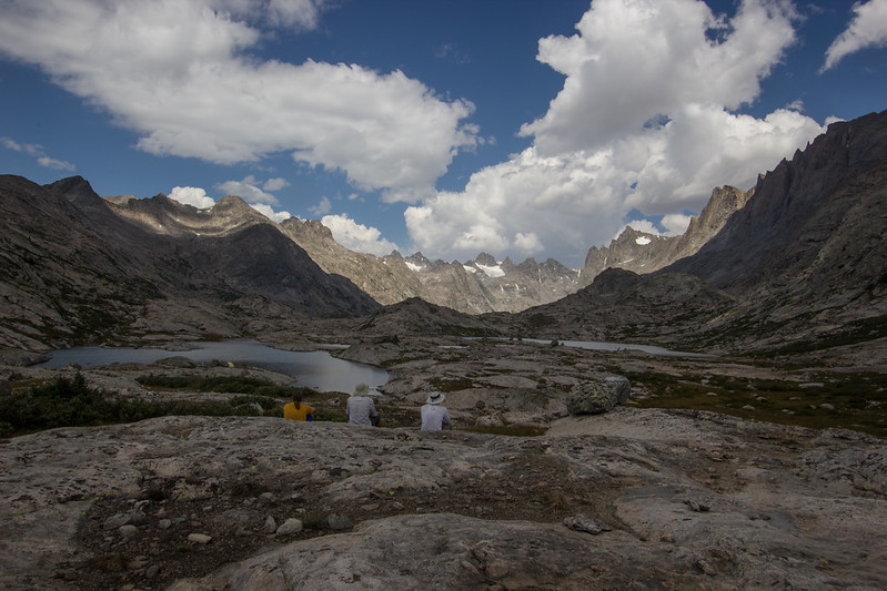
Our group shots from the trip at our campsite at Island Lake looking up into Titcomb Basin

From left: me, @slc_dan, @Smokey and @Ndheiner

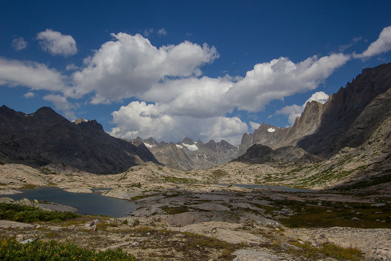
Eventually I decided it just wasn't smart for me to continue to Titcomb, but I wasn't going to deny everyone else a chance to at least go in and take a peak. We hiked around the lake to the main trail where I watched packs and hung out under a tree while they did a day hike in awesome conditions up into the basin. The views from my spot weren't too shabby but I imagine theirs were a little better.

After a 2 or 3 hours the guys made it back and we had a quick lunch before starting out way out towards Elkhart Park. We planned to hike out about half way and camp one more night before the final stretch. The views climbing the pass out of Island Lake were even better than sitting at the lake.


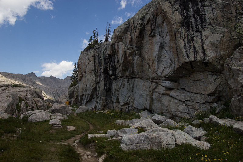
A few miles later we were back to terrain I was familiar with from my trip last year to this area. This is the turnoff to Lost Lake near Seneca Lake.

We eventually settled into a nice spot at Hobb's Lake for the night. The fishing was tough but We still caught a few fat rainbows. Later in the evening we noticed haze starting to fill the air a bit.

That night was one of the clearest nights of the trip. We stayed up late staring at stars and talking about constellations. I didn't bother to put on my rain fly which made it even more of a shock in the morning to wake up to a helicopter above me and a now smoke-filled sky.
I'm still not quite sure where it all came from but the smoke moved in thick overnight. The helicopters appeared to be heading to the upper Pole Creek drainage. The lighting was a bit surreal at times during the hike out. Diffused and golden or just overcast. By the time we past Photographer's Point, you could barely even tell what was out there.

6 days later, we see our first cars at the Elkhart Park trailhead. A whole lot more cars here than the last time I saw it! My truck was waiting for us conveniently right there near the front of the lot. Thank you Great Outdoors Shop!

With the day hike into Titcomb, the rest of the guys put down a solid 50 miles. And even with my jacked up knee and blister from hell, I was not far behind. Salud!

I had to get some pictures of Taylor's feet after the trip. Taylor is a member of what I call the 'cult of chaco'. I'm not talking about Chaco Canyon or any kind of Anasazi, prehistoric indian thing. I'm talking about people who wear chacos for everything. I don't really care what anyone wears on their feet, but I can't help but cringe from time to time. This is what 50 miles in Chacos look like. I've gotta give him credit though, I've seen a LOT more tape and blood on people wearing Chacos for far fewer miles on desert hikes.

The best part was all the people who stopped him in the last 10 or 12 miles to point out the fact he wasn't wearing boots. One guy didn't even say hello, he just said "how're those sandals treating you!?" while an older lady asked if we had had some kind of accident and lost his shoes. Hilarious.

We had planned to car camp near the trailhead that night but it was just late afternoon so we decided to head into Pinedale for a victory meal/beers at the Wind River Brewery. I had never been there before but it is now a ritual for me when finishing a hike near Pinedale. Highly recommended! Go sit upstairs assuming the range isn't blanketed in smoke - you'll love it.
After dinner we started our way back to Salt Lake and found a nice campsite along the Green River to spend the night. We did a little fishing but only caught one or two.
The best part came after dark when the coyotes came out. They were very vocal in the area. So much that when we started howling back at them, they howled back at us. New coyotes even appeared from different directions and howled back and forth with us. It was wild and such a great way to finish off an amazing week. Going into this trip, I was worried that 6 days was a long trip. Now I know that even that is just getting started. Thanks for reading.

Here's a map with my GPS tracks and out campsites for the trip:
View larger map.
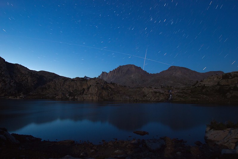
Featured image for home page:

After our wet day getting from Elbow Lake to Lower Jean Lake, we were pleasantly surprised to wake up to beautiful blue skies. But as with any day in the Wind Rivers, these blue skies should not be trusted! But it didn't stop us from taking in a very leisurely morning. We had a lot of wet gear from the day before and the time in the tents had us itching to get down to the water and try a little fishing.
Dan and I made it down a little ahead of the others and quickly realized the fishing was fantastic for nice sized cutthroat trout in Lower Jean Lake. Dan was knocking them dead on a Jake's spinner and I was doing great on my fly rod with a renegade. It was my first successful fishing of the trip and it felt great to just kick back in the sun and reel them in. Here's a nice one that Dan caught.
There were tons of these moth/butterfly things flying around and they really seemed to love my backpack!
Eventually Nate and Taylor made their way down to the shore with us and after another round of fishing we were finally on our way. Our destination for the day - Titcomb Basin. The weather was looking great.
The walk along Lower Jean Lake was just sublime. Big 'super mario' clouds like Nate calls them and wide open tundra dotted with huge granite boulders. Outstanding.
Taylor on the trail.
As we descended into the Fremont River valley, we ran into a large group of people with dogs and lots of very young children. They were out on what sounded like a very ambitious day hike from their base camp at Big Water Slide Lake. We stopped to talk, first things first, the dispelled my dreamy vision of what Big Water Slide Lake might be like. According to them there was indeed a big water slide feature but sliding on it would likely be fatal. Oh well. But what they did tell us is that there is a nice shortcut to get us to Island Lake faster than taking the trail on the topo maps.
After crossing the Fremont River bridge, we should drop off the trail and follow the river up to Island Lake. At first there wasn't much sign of passage but eventually we were following a nice social trail. I could have happily stopped and camped anywhere along the river here.
As we approached Island Lake, the trail left the river and started cutting up through small tarns and mounds of granite as it wound it's way to the lake. Meanwhile a storm was coming in hard. We weren't sure if we were going to make it to Island before it hit us but we just kept going.
We got to Island Lake and an amazing campsite just as the rain started to come down. It was light and windy at first as we watched a massive storm roll down Titcomb Basin on the other side of the lake. We hadn't intended to camp here but none of us were very interested in another wet day like the one we had yesterday so we setup tents and got ready for the storm.
This being our 4th day on the trail, I was actually surprised that I hadn't had any solo time in the tent waiting out storms so I was honestly kind of excited for it. Sure, I really wanted to get into Titcomb but an afternoon of snoozing and reading to the sound of rain on the fly sounded fantastic. The rest of the guys retreated to Taylor's circus tent to hang out but I opted to just relax on my own. It was great. The storm was strong at times - so strong that it really put my tent poles to the test, but eventually the sound of rain drops slowed to a stop. Time to stretch the legs...
I crawled out of the tent to one of the most amazing things I've ever seen in the backcountry. An amazing 'cotton candy' layer of clouds resting right on top of the continental divide, pouring over the edge towards us like a massive vaporized waterfall. It didn't photograph very well so I tossed in a handful of shots of it. The wind was still howling and bitter cold but we all got out and just stood in awe of it.
The rest of the day was dry but very windy and unsettled. Fishing sucked. We all tried our best but there was almost no activity. The one fish we saw rise, I caught. I literally ran down to the shore and cast into the zone and got it. And then I think I caught it again an hour or so later. Just a tiny little rainbow.
Meanwhile there was a group camped across the lake near the waterfall you see in the pics that would occasionally hike over and catch fish near the waterfall.
Sunset wasn't particularly great that night but the late evening light was nice.
That night we had a fire and stayed up pretty late. Despite a really short day of hiking, I woke up the next day with the worst knee pain and swelling I had experienced since shortly after my surgery. I couldn't even come close to bending it to 90 degrees and it was clearly very swollen. I took my usual morning mega-dose of ibuprofen to try and get it under control but after packing up it was still no better. Reluctantly, I told the guys I was in a bad situation. We were all very gung-ho on getting into Titcomb but this was not good. We were still something like 13 miles from our exit trailhead and only one night left to do it. We had the option of doing two more nights if needed but supplies might have been tight and just walking was becoming difficult.
Our group shots from the trip at our campsite at Island Lake looking up into Titcomb Basin
From left: me, @slc_dan, @Smokey and @Ndheiner
Eventually I decided it just wasn't smart for me to continue to Titcomb, but I wasn't going to deny everyone else a chance to at least go in and take a peak. We hiked around the lake to the main trail where I watched packs and hung out under a tree while they did a day hike in awesome conditions up into the basin. The views from my spot weren't too shabby but I imagine theirs were a little better.
After a 2 or 3 hours the guys made it back and we had a quick lunch before starting out way out towards Elkhart Park. We planned to hike out about half way and camp one more night before the final stretch. The views climbing the pass out of Island Lake were even better than sitting at the lake.
A few miles later we were back to terrain I was familiar with from my trip last year to this area. This is the turnoff to Lost Lake near Seneca Lake.
We eventually settled into a nice spot at Hobb's Lake for the night. The fishing was tough but We still caught a few fat rainbows. Later in the evening we noticed haze starting to fill the air a bit.
That night was one of the clearest nights of the trip. We stayed up late staring at stars and talking about constellations. I didn't bother to put on my rain fly which made it even more of a shock in the morning to wake up to a helicopter above me and a now smoke-filled sky.
I'm still not quite sure where it all came from but the smoke moved in thick overnight. The helicopters appeared to be heading to the upper Pole Creek drainage. The lighting was a bit surreal at times during the hike out. Diffused and golden or just overcast. By the time we past Photographer's Point, you could barely even tell what was out there.
6 days later, we see our first cars at the Elkhart Park trailhead. A whole lot more cars here than the last time I saw it! My truck was waiting for us conveniently right there near the front of the lot. Thank you Great Outdoors Shop!
With the day hike into Titcomb, the rest of the guys put down a solid 50 miles. And even with my jacked up knee and blister from hell, I was not far behind. Salud!
I had to get some pictures of Taylor's feet after the trip. Taylor is a member of what I call the 'cult of chaco'. I'm not talking about Chaco Canyon or any kind of Anasazi, prehistoric indian thing. I'm talking about people who wear chacos for everything. I don't really care what anyone wears on their feet, but I can't help but cringe from time to time. This is what 50 miles in Chacos look like. I've gotta give him credit though, I've seen a LOT more tape and blood on people wearing Chacos for far fewer miles on desert hikes.
The best part was all the people who stopped him in the last 10 or 12 miles to point out the fact he wasn't wearing boots. One guy didn't even say hello, he just said "how're those sandals treating you!?" while an older lady asked if we had had some kind of accident and lost his shoes. Hilarious.
We had planned to car camp near the trailhead that night but it was just late afternoon so we decided to head into Pinedale for a victory meal/beers at the Wind River Brewery. I had never been there before but it is now a ritual for me when finishing a hike near Pinedale. Highly recommended! Go sit upstairs assuming the range isn't blanketed in smoke - you'll love it.
After dinner we started our way back to Salt Lake and found a nice campsite along the Green River to spend the night. We did a little fishing but only caught one or two.
The best part came after dark when the coyotes came out. They were very vocal in the area. So much that when we started howling back at them, they howled back at us. New coyotes even appeared from different directions and howled back and forth with us. It was wild and such a great way to finish off an amazing week. Going into this trip, I was worried that 6 days was a long trip. Now I know that even that is just getting started. Thanks for reading.
Here's a map with my GPS tracks and out campsites for the trip:
View larger map.
Featured image for home page:


")
