Interesting/mysterious patterns Needles District, Canyonlands

SeanIsADesertRat

Member
.
Joined
Jan 16, 2022
Messages
21
I was doing some virtual exploring of the Needles District in Canyonlands with Google Earth, when I noticed some odd patterns. The rectangles on the left side are about 100 ft by 20 ft. The group of two rectangles near the middle are about 85 ft by 18 ft. The other 7 rectangles are about 65 ft by 16 ft. The shape that is roughly trapezoidal is about 60 ft on the long side and about 34 ft across. I'm sure there is a good explanation for these tracks/trails, but I have no idea what it might be.

I prefer not to mention exactly where this is in Canyonlands, since the National Park Service does not want this area visited by anyone other than the anointed few doing research.
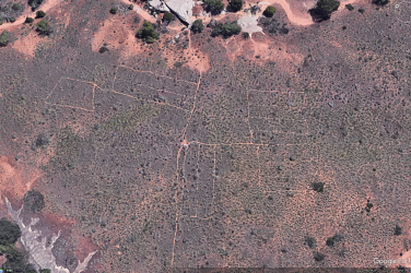
CanyonlandsPatterns.png
 
Didn't you answer your own question: research? The area is one of the few in that habitat type on the Colorado Plateau that has never been grazed by domestic livestock. It seems these are plots to me to study native plant community, but i am not a scientist. It does seem a bit destructive in its own right. In the name of science...
 
Didn't you answer your own question: research? The area is one of the few in that habitat type on the Colorado Plateau that has never been grazed by domestic livestock. It seems these are plots to me to study native plant community, but i am not a scientist. It does seem a bit destructive in its own right. In the name of science...
Seems likely enough that it is some research, but it's difficult (for me at least) to imagine a scenario where they'd need to plot out rectangles like that.
I also feel a sense of disappointment in the park service when they close an area like this for scientific research reasons, but don't regularly share information about studies that have been completed, are currently underway, or are in the planning.
Totally agree. If true that no grazing took place becasue of limited geographic access I do get the secrecy in a sense since weed seed is often all over our clothes and shoes. I understand that you can ask at the VC specifically for dates of guided walks to the site with rangers . I cannot get there when they are offered. They would have our answer! In the center is a whiteish rectangle of sorts, perhaps a cache box for tools/equip.
The secrecy also likely predates Google Earth and we'd have no sense of what we are missing!
 
This always makes me laugh because it comes up about every few years with someone seeing it on GE and wondering what the heck it is!! I'm sure if you search Virginia Park it will come up a few times with different threads just on BP. A few years back one of the Utah TV stations did a report on it with the NPS letting them take a camera in on a guided tour and I think they regretted it the moment it aired. Funny how once we are told an area is closed off to the public.....we want to see it even more!

I think it was closed to the public in the early 90s.
 
Last edited:
Totally agree. If true that no grazing took place becasue of limited geographic access I do get the secrecy in a sense since weed seed is often all over our clothes and shoes. I understand that you can ask at the VC specifically for dates of guided walks to the site with rangers . I cannot get there when they are offered. They would have our answer! In the center is a whiteish rectangle of sorts, perhaps a cache box for tools/equip.
The secrecy also likely predates Google Earth and we'd have no sense of what we are missing!
In Kelsey's book from 1992 mentions that the park rangers would never mention this place, and would knock down any cairns they found that would lead people to it. Apparently, access was officially restricted the following year.
 
I enjoyed reading this https://historiumunearthia.com/wp-content/uploads/2018/12/Denis-2014.pdf

Shisler Park is not mentioned anywhere on the internet besides this one publication, as far as I can tell, and also there's very little information about Starvation Pocket. both would be fun to visit, but neither is easy to get to, that I can see, without an Elephant-Hill-capable vehicle
 
Last edited:
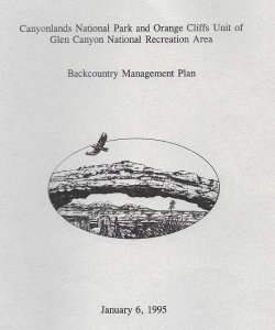
The official " official " closure of this area was in the spring of 1995 with this management plan ,although the area was likely managed as closed earlier in the 90's. I participated in the scoping process for the management plan and thus was on the mailing list. I was able to make a brief walking visit to the area during one of my many trips to The Needles in the 80's before the closure. According to the management plan you are allowed to view the area from the surrounding rock formations , just keep your distance I guess.

Image (4).jpg
 
Yes, it was my understanding from the management plan that, so long as you stay on the rocky surrounds, it is ok to approach the study area.

"Views ... will still be possible from rock formations around the grasslands"

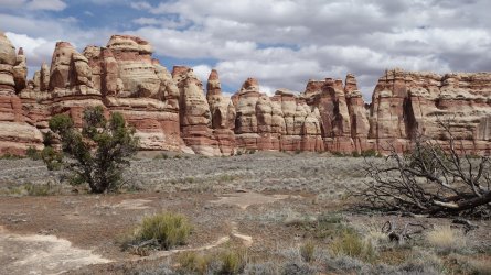
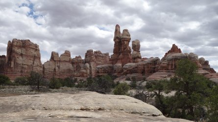
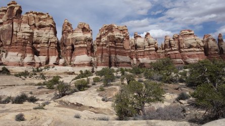
Despite this, it was still a nervy trip for me, as I hiked there a few years ago ... I did wonder if there were perhaps some NPS high-altitude surveillance drones watching my every step, as I headed there :) ... I was very careful to stay on the rocks. It is possible to see parts of the scientific monitoring equipment. It is pretty cool to think that this is one of the very few areas in this entire region that has never been trampled by modern humans or livestock.

The views are very pretty, of course, but not quite as stunning or expansive as Chesler Park.

DSC00095.JPGDSC00086.JPGDSC00098.JPG
 
Funny how once we are told an area is closed off to the public.....we want to see it even more!

YES! Exactly… But there are so many other awesome areas off trail and @TrailScot has given us plenty of cool inspiration.

@SeanIsADesertRat : There is a yearly trip for the rangers, as mentioned by @John Morrow . Two BCP’ers helped out a ranger in 2021 and then got invited on that fall trip into VP. So if you see a ranger vehicle stuck in the mud, be helpful ;).
 
Seen this area way back .. can't remember.

Just another way to close off land areas... Limiting people to their land.
 
On my first trip to canyonlands, I was eating breakfast in Chesler Park and a few rangers passed by and asked if I wanted to join their group on its annual visit to Virginia Park (since they had one or two people cancel and they saw that I was solo). After a moment of hesitation, I declined, since I was really excited for my itinerary. In hindsight, I wish I'd taken them up on the offer, since I've had multiple chances to go back and explore the needles since then. Oh well.
 
The whole area around Chesler park is ripe for exploration, it wasn't really a "secret", but NPS doesn't want to advertise. Part of the problem was the published USGS topographic maps showed the name and the trail, though I think travel was discouraged even as far back as the late 1980s. Chesler park itself was open to 4WD for years prior to that of course.

I liked Needles district better when the visitors center was a double wide. What did they do before that, I dunno.
 

Similar threads

Back
Top