Navigation
Install the app
How to install the app on iOS
Follow along with the video below to see how to install our site as a web app on your home screen.
Note: This feature may not be available in some browsers.
More options
You are using an out of date browser. It may not display this or other websites correctly.
You should upgrade or use an alternative browser.
You should upgrade or use an alternative browser.
Ice Lake, Yellowstone National Park - September 14, 2018
- Thread starter scatman
- Start date
-
- Tags
- wyoming yellowstone
- Joined
- Dec 23, 2013
- Messages
- 4,295
@Rockskipper - I think I owe you a Circles' story.
A few years back, a group of us backpacked into Big Bear Lake, located on the Madison Plateau, on the western side of the park. Normally you are required to stay at a designated backcountry campsite, but on this trip I was able to secure a site at an non-designated site after getting permission from the regional ranger of that area. It was essentially all off-trail, starting out through Dry Canyon, popping up and onto the Plateau and then eventually dropping down into the basin where the lake is located. It was approximately 7.5 miles into the lake and the going was strenuous. While Dry Canyon wasn't burned form the '88 fires, there was plenty of downfall to contend with. Once on the plateau, we had to contend with the burn all the way to the lake.
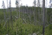
Lay of the land on our way to Big Bear Lake
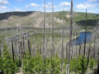
Big Bear Lake from the eastern ridge
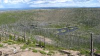
Big Bear Lake from the western ridge
After three days at the lake, we chose a different route back to our vehicle that took us up on the western ridge of the basin and then we dropped down into Meadow Canyon, hiked back up onto the Madison Plateau and made a straight beeline to the van. Now this straight line route was through old growth and was pleasant enough hiking. We even made our way along by some unnamed ponds (I like ponds) to keep things interesting. Let me back up a bit, and tell you that before we backpacked into Big Bear Lake, I sat down and entered some waypoints into my Magellan Explorist 100 for this straight stretch through the forest in case we needed them to keep us on the straight and narrow. Now the Explorist 100 is a pretty simple unit, it doesn't contain any maps, has a black and grey screen, and there is no way to download gps data to the unit or upload a route or points to a computer. You just mark points and the points appear on the screen as you approach them.
So as we make our way past the second unnamed pond, my friend, formally known as Jeff or Jeffery, comes over to me and in all seriousness says, "I think we are going in circles." "We have already passed this pond and I noticed some rocks that I'm sure we have passed by previously." I assured him that we were not going in circles, but he refused to believe me. So then I reached into my pocket and pulled out the Explorist and turned it on. Sure enough, we were pretty close to the line of waypoints I had marked back at home, but this didn't convince Jeff of anything.
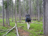
Type of terrain we were hiking through for 2-2.5 miles - Does it look like we are going in circles?
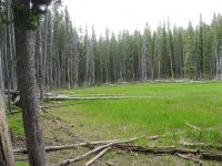
The second unnamed pond - actually both ponds were dry. Circles was very confused at this point.
Jeff assured me that my gps unit had to be wrong. I told him that it had never let me down in the past through more sketchy areas than this trip (think Old Fountain Trail). Well, Jeff had had enough trying to convince me, and he made his way to other members of our group to try and convince them that we were going in circles and that we needed corrective action at once.
Imagine Jeff's surprise when we popped out of the trees, only to see the van a hundred yards or so ahead of us. So from that day on, he is affectionately known as Circles.
Hey, notice how I was able to insert a completely different trip report into this one. Pretty sneaky I am.
A few years back, a group of us backpacked into Big Bear Lake, located on the Madison Plateau, on the western side of the park. Normally you are required to stay at a designated backcountry campsite, but on this trip I was able to secure a site at an non-designated site after getting permission from the regional ranger of that area. It was essentially all off-trail, starting out through Dry Canyon, popping up and onto the Plateau and then eventually dropping down into the basin where the lake is located. It was approximately 7.5 miles into the lake and the going was strenuous. While Dry Canyon wasn't burned form the '88 fires, there was plenty of downfall to contend with. Once on the plateau, we had to contend with the burn all the way to the lake.

Lay of the land on our way to Big Bear Lake

Big Bear Lake from the eastern ridge

Big Bear Lake from the western ridge
After three days at the lake, we chose a different route back to our vehicle that took us up on the western ridge of the basin and then we dropped down into Meadow Canyon, hiked back up onto the Madison Plateau and made a straight beeline to the van. Now this straight line route was through old growth and was pleasant enough hiking. We even made our way along by some unnamed ponds (I like ponds) to keep things interesting. Let me back up a bit, and tell you that before we backpacked into Big Bear Lake, I sat down and entered some waypoints into my Magellan Explorist 100 for this straight stretch through the forest in case we needed them to keep us on the straight and narrow. Now the Explorist 100 is a pretty simple unit, it doesn't contain any maps, has a black and grey screen, and there is no way to download gps data to the unit or upload a route or points to a computer. You just mark points and the points appear on the screen as you approach them.
So as we make our way past the second unnamed pond, my friend, formally known as Jeff or Jeffery, comes over to me and in all seriousness says, "I think we are going in circles." "We have already passed this pond and I noticed some rocks that I'm sure we have passed by previously." I assured him that we were not going in circles, but he refused to believe me. So then I reached into my pocket and pulled out the Explorist and turned it on. Sure enough, we were pretty close to the line of waypoints I had marked back at home, but this didn't convince Jeff of anything.

Type of terrain we were hiking through for 2-2.5 miles - Does it look like we are going in circles?

The second unnamed pond - actually both ponds were dry. Circles was very confused at this point.
Jeff assured me that my gps unit had to be wrong. I told him that it had never let me down in the past through more sketchy areas than this trip (think Old Fountain Trail). Well, Jeff had had enough trying to convince me, and he made his way to other members of our group to try and convince them that we were going in circles and that we needed corrective action at once.

Imagine Jeff's surprise when we popped out of the trees, only to see the van a hundred yards or so ahead of us. So from that day on, he is affectionately known as Circles.
Hey, notice how I was able to insert a completely different trip report into this one.

- Joined
- Jun 11, 2017
- Messages
- 4,584
The Land of Snags and the Tale of Circles.
I think you should do a Ted Talk of your escapades. @Chuck the Mauler and the Maulers could provide background effects.
I think you should do a Ted Talk of your escapades. @Chuck the Mauler and the Maulers could provide background effects.
- Joined
- Dec 23, 2013
- Messages
- 4,295
The Land of Snags and the Tale of Circles.
I think you should do a Ted Talk of your escapades. @Chuck the Mauler and the Maulers could provide background effects.
The Land of Snags and the Tale of Circles - I like your title.
Those folks at Ted Talk have a lot more in the upper story than I do. I like the crash course in Organic Chemistry in 15 minutes. I could have used that in college. Organic Chem was the hardest class that I took.
I think I would need somebody more dignified than the Maulers to back me up though.
- Joined
- Jun 11, 2017
- Messages
- 4,584
If you took organic chemistry, you’re :twothumbs:
Hey, you could title your talk something like Using a Compass to Find Circles!
Hey, you could title your talk something like Using a Compass to Find Circles!
NorthwestWanderer
Member
- Joined
- May 3, 2018
- Messages
- 292
walk along the road due to a Dutch study that found that walking along roadways with vehicles causes brain damage
wat
- Joined
- Dec 23, 2013
- Messages
- 4,295
Exactly!
If you took organic chemistry, you’re :twothumbs:
Hey, you could title your talk something like Using a Compass to Find Circles!
How about this title - Just leave Circles in the woods
- Joined
- Jun 11, 2017
- Messages
- 4,584
Leave no Circles?
The Trout Whisperer
Member
- Joined
- Jan 18, 2014
- Messages
- 461
This report covers a four day backpacking trip into Ice Lake in Yellowstone National Park, starting on September 14th and running through the 17th. This trip was with three of my old backpacking buddies who are getting a bit long in the tooth and don't get out much anymore. One in particular will be going in for more back surgery in two weeks, so it was nice getting him out into the backcountry one more time, albeit a short (distance) one.
Ice Lake is located on the edge of the Solfatara Plateau and is just a short distance from the trailhead. The best campsite on the lake is 4D2, which is located on the east side of the lake, and the one which I reserved for three nights for our group. Along with hiking into the lake, we planned on doing a day hike the second day to Little Gibbon Falls, a bushwhack to some meadows along the Gibbon River, and on day three, a hike up to Wolf Lake and some exploration of the meadows to the north of the lake.
Temperatures were pleasant with high's in the low to upper sixties and the lows being in the low thirties down to twenty three degrees on our last night. Each night, we were fortunate enough to have bugling elk help us drift off to sleep and in the mornings have Canadian Geese honking to wake us up.
Here are some shots of the trip.
Day 1 - Hike into the lake
View attachment 69092
Our route into campsite 4D2 on Ice Lake
View attachment 69085
The Geriatric Squad (GS) - sometimes confused with the more popular Suicide Squad.
View attachment 69086
Both ways point to Ice Lake, so how could we go wrong.
View attachment 69087
Check out this mess! He brought enough food in to feed seven people.
View attachment 69088
Campsite 4D2
View attachment 69089
A look at the food area at 4D2
View attachment 69090
The Geriatric Sqaud (GS)likes to cut wood.
View attachment 69091
Sunset on Ice Lake
Day 2 - A day hike to Little Gibbon Falls and two of us off-trailed up the Gibbon River to check out two separate meadows.
View attachment 69093
Map showing our route to Little Gibbon Falls (purple line) and the off-trail route up the Gibbon (blue line).
View attachment 69094
I was a bit chilly in the mornings. I sort of look like a WW1 german soldier.
View attachment 69095
Ice Lake viewed from campsite 4D2 in the morning
View attachment 69096
The Ice Lake Marriott
View attachment 69097
I'm starting to get hangry!
View attachment 69098
Too late, somebody better feed me some breakfast and quick! How do you like my grizzly impersonation
@Rockskipper? I'm lucky one of my backpacking counterparts didn't spray me with bear spray.
View attachment 69099
Crossing the Gibbon River on our way to Little Gibbon Falls
View attachment 69100
The GS (Geriatric Squad)likes sign posts
View attachment 69101
Beginning our descent down to the falls
View attachment 69102
It only took one finger
View attachment 69103
Little Gibbon Falls
View attachment 69104
The GSlikes sitting by rivers
View attachment 69105
Good view of my better half. I'm checking out a tree that fell over the cliff and is completely upside down.
View attachment 69106
Little Gibbon Falls from above
View attachment 69107
Beginning the bushwhack up the Gibbon River
View attachment 69108
The first meadow - the golden grass was beautiful and the wind blowing across it made for waves in the
tall grass. I could have stayed here all day.
View attachment 69109
The Gibbon cutting through the meadow
View attachment 69110
The going is getting a little rougher
View attachment 69111
The beginning of the second meadow
View attachment 69112
Gorgeous place to eat lunch. Love it!
View attachment 69113
Check these out, 45 year old boots - special issue for the GS.
View attachment 69114
A Blue Heron takes flight on our way back down the River
View attachment 69147
Ha! Watch out for that hole! Usually it is Scatman that falls down, but this time Circles had the pleasure.
My guess is it was those 45 year old boots of his.
View attachment 69115
I'll take a pint of Plain please.
View attachment 69116
Our friend back at camp.
View attachment 69117
Fall colors along the lake
Day 3 - A day hike to Wolf Lake, along with about a half mile of temporary insanity on the way back.
View attachment 69148
Map of our day hike to Wolf Lake (red route), along with our off-trail hike into the meadows north of Wolf Lake (aqua route), and our little insane bushwhack on our way back to camp (blue route).
View attachment 69118
View on the way to Wolf Lake
View attachment 69119
First sight of Wolf Lake
View attachment 69120
Wolf Lake and Observation Peak in the distance on the right
View attachment 69121
The mighty Gibbon River, leaving Wolf Lake
View attachment 69122
Heading off to investigate the meadows north of the lake
View attachment 69123
These ducks' backsides have nothing on me. See previous image at Little Gibbon Falls for a comparison
if you can stand it.
View attachment 69124
Walking the meadows
View attachment 69125
An old beaver lodge on the lake
View attachment 69126
View to the north, just north of Wolf Lake
View attachment 69127
A view up the second segment of the finger meadow. We stopped here for lunch.
View attachment 69128
My Scatman senses tell me this is a bear day bed.
View attachment 69129
More fall colors at ground level
View attachment 69130
What? Sleeping on the job! We may have to kick this one out of the Squad.He was supposed to be
on bear watch.
View attachment 69131
Well, I guess this is what a power nap will do for you. The GSlike to teeter-totter.
View attachment 69132
Ride 'em cowboy!
Mamas don't let your babies grow up to be cowboys. Don't let 'em play guitars and drive
them old trucks. Let em be doctors and lawyers and such.
View attachment 69133
Another gorgeous meadow as we make our way back to camp.
View attachment 69134
Well, this is where the .4 miles of insanity begins. These little cascading
falls aroused our curiosity. Did they begin on the ridge as a spring or a
creek flowing off of the ridge? Inquiring minds just had to know.
View attachment 69135
Crossing the Gibbon to get a closer look at the cascades
View attachment 69136
Is the pole big enough for ya Circles? Nice aspen on the ridge above
View attachment 69137
At the source - a spring (so we thought). Looking back down on the Gibbon River. Watercress anyone?
It appeared to be a spring but after looking at the 7.5 minute map when I got home it looks like it might
come from a couple small ponds on top of the ridge. Needless to say, I drank a whole liter from where it
emerged on the side of the hill. Tasty!
View attachment 69138
Instead of heading back down the hill to the trail, these bozos decided to bushwhack back to the trail
through this and thus the .4 miles of temporary insanity.
View attachment 69139
This doesn't seem so bad. Uh-huh
View attachment 69140
Argh!
View attachment 69141
Double Aargh! Hey @Artemus, this looks like your kind of territory.
View attachment 69142
When do we get out of this Shite? I'll have a pint of Plain please. :twothumbs:
View attachment 69143
Finally back on the trail and we run into one of these. Anybody care to take a guess at what made it?
There is a story behind this if anyone is interested.
View attachment 69144
Fall colors along the river
View attachment 69145
The GSlike to fly kites. It was actually so windy that we could not have a fire this night.
That just about wraps it up for Ice Lake. We hiked out the next day and headed for Ponds for some pizza and a beer. But on our way ..........
View attachment 69146
We saw a bull moose standing in the middle of the Henry's Fork of the Snake on our way home.
The end.
The Trout Whisperer
Member
- Joined
- Jan 18, 2014
- Messages
- 461
Been perusin’ all th backpackin trip reports...wow...but th one thing I’ve noticed most is Hugh’s uncanny ability to color coordinate his kilt attire! That guy is ready to walk down th old fashion show runway!
- Joined
- Dec 23, 2013
- Messages
- 4,295
Been perusin’ all th backpackin trip reports...wow...but th one thing I’ve noticed most is Hugh’s uncanny ability to color coordinate his kilt attire! That guy is ready to walk down th old fashion show runway!
It's a requirement.
Don't like ads? Become a BCP Supporting Member and kiss them all goodbye. Click here for more info.
