Hurricane Pass/Jedediah Smith Wilderness

marquiri

Member
Joined
Jan 15, 2018
Messages
94
Good morning all,

I'm trying to confirm the status of the alleged trail down the West side of Hurricane Pass into the Roaring Creek drainage eventually rejoining the Alaska Basin trail. Caltopo's map builder layer shows an unmaintained trail, and I've seen the same trail on a couple of other apps, but it's not a maintained NFS trail. Just wondering if anyone has used this trail and share any information so I can make a decision whether or not it's something my group would want to take on. Thanks so much everyone.
 
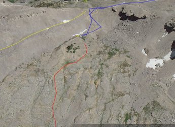
Not sure which one you are asking about..... here is what I have/see in trails there. Red is a definite used trail. Orange are trails that are there but not as defined in places. Blue is route we went on the Teton Crest trip.... I would say the orange ones would be not difficult to find. Terrain is not that bad

Click here to view on CalTopo
 
Thanks for the response Bob. The unmaintained trail I'm talking about is in the image below (between the blue lines). It only shows on the Caltopo map builder layer. Nothing in the NFS trail data set.1000002115.png
 
Ok...plotted it on my previous map. red line from Hurricane Pass. Dashed red is across rock so you cannot see it on GE, but it's there. I can see about 90% of it, looks like a decent trail, hooks into the South Fork just upstream from where Roaring Fork meets. We fit 4 people in the C5 spot (no Water) just outside the Park. If you don't camp in the Park you don't need Bear canisters.
 
Last edited:
Thanks Bob. Not a lot of trail beta about this segment out there on the internet. I did find one short video on youtube of a group who did it, and the trail looked pretty clear. Not much footage of the final push to the pass though, which is the part I'm most curious about. Not everyone enjoys steep loose rock!
 
The steeper loose rock section (top to C5) has a very well defined packed trail. Below C5 I have not been but it appears to be hard packed dirt or exposed rock layer. There is only one section you cannot see a trail on it, but I'd gues its there on solid rock. All in all, looks like a decent trail. I'm sure a ton of people go up it to see the so called Schoolroom Glacier which is not very impressive.

a tt.jpg
 

Don't like ads? Become a BCP Supporting Member and kiss them all goodbye. Click here for more info.

Back
Top