Horse Canyon on Canyonlands

Carlos

Member
Joined
Jan 24, 2014
Messages
86
I hiked the Peekaboo trail in the Needles this past Thanksgiving and I am coming back in late March to hike that area again (day hike). As part of the hike I went into Horse Canyon and I hiked as long as time permitted (which was not much), but I managed to find Paul Bunyan's Potty (just in distance, next time I will hike up to it) and then Tower Ruins. I ran out of time, so I didnt try to get close to it.

My question is: how close can I get to the ruins ? I have seen a You Tube video of someone that took it from the rock formation next to it. I hike alone, so I dont want to take unnecessary risks, and I am very careful with ruins. Obviously you can get to the ruins because people lived there, but I want to make sure that is still the case that someone can hike up to them in a safe manner.

Also, are there any ruins to explore close to Paul Bunyan's Potty of somewhere in that vicinity ?

After the Tower Ruins, should I continue hiking into the canyon ? I have seen in Google Earth some tags of some arches further into the canyon, but I am not sure if its worth the hike. As a reference, I love to photograph the needle rock formations, so if there are more further into the canyon that would be great to know.

I know about Salt Creek Canyon (in case someone suggests it); that is also part of my March hiking trip.
 
Tower Ruins are pretty inaccessible unless you are a rock climber. I would guess when they were inhabited that they used a ladder to access this location. You can see them from the ledge below the site.

Horse Canyon is a great place to explore and there is a lot of stuff to see further up canyon!

http://adventr.co/2012/07/the-elusive-horse-canyon/


great trip report !!!

Quick question: how far from Tower Ruins is the Thirteen Faces pictographs in miles ? I keep googling about it and I cant find a general location. Same with 9 faces :(
 
great trip report !!!

Quick question: how far from Tower Ruins is the Thirteen Faces pictographs in miles ? I keep googling about it and I cant find a general location. Same with 9 faces :(

Drawing a quick track on a map, it looks like about 4 miles past the turnoff for Tower Ruin. Thirteen Faces is marked on USGS topo maps.
 
Drawing a quick track on a map, it looks like about 4 miles past the turnoff for Tower Ruin. Thirteen Faces is marked on USGS topo maps.
oh yes, just checked the topo maps and I see them there. Thanks !!!
 
I
Drawing a quick track on a map, it looks like about 4 miles past the turnoff for Tower Ruin. Thirteen Faces is marked on USGS topo maps.


OH WAIT !!! I remember you now. I have been looking for the Cave of 200 hands and rock art in the Devils Kitchen are in the Needles and I saw this website (http://www.myxj.net/blog/cyclone-canyon-the-devils-pocket/#more-6749) and I realize that is you. Could you please give me an approximate location of it ? I will be there in March and I was thinking of hiking Devil's Lane from Devil's Kitchen into SOB Hill because I suspect its there, but that is a big area and I might miss it again. How about the location of that second trapezoidal anthropomorph panel ?
 
When I was in Horse it had long been closed to vehicles and the whole area beyond Tower seemed very remote and almost forgotten.

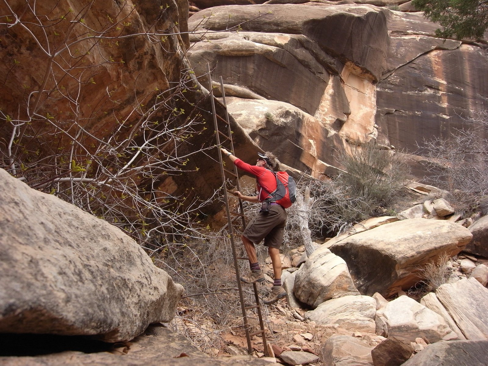
I think the two arches up Horse are well worth the distance. Especially one of them, don't remember which, have an interesting trail with this ladder somewhere along the way:

image by jan nikolajsen, on Flickr
 
Horse is truly wonderful when the jeep trail is out. I've been there twice to backpack and never saw anyone past the Potty. Tower is inaccessible like IntrepidXJ says but with some friction skills you can get nearly level with it (his pics). Hardest part is lack of water and annoying deep sand for the first few miles. Take binocs, avoid the crust, and go explore. You'll discover stuff. That's how I found 11Faces. I have found pothole water a week after rain and even seep pools in a sand wash of side canyons, but don't count on it. It bought me an extra day/night of exploring from a basecamp with my Salt/Horse 3 night permit. Many arches if you like those.
 
Similar threads
Thread starter Title Forum Replies Date
WhozWutz Invite Horse Canyon Needles Meet Up (Members Only) 1
H location of thirteen faces-horse canyon Utah Hiking & Camping 4
H Horse Canyon needles district Utah Off Road 0
OwenM Hiking Horse Canyon? Trip Planning 4
Stephanie B Old Woman Wash, Three Finger Petroglyphs, and Wild Horse Canyon (Backcountry Fest in the San Rafael Swell) Hiking & Camping 6
Devin Ashby The Gulch to Horse Canyon Loop - From Burr Trail Trip Planning 5
P Info for The Gulch to Horse Canyon Loop. (canyoneering 3 # 32) Trip Planning 11
Stephanie B Horse Pasture Canyon Ruin Trip Planning 0
RyanP Little Wild Horse tips for this weekend? Deep cold water in canyon? Trip Planning 5
ashleyoutside Slot Canyon Hiking – Little Wild Horse Canyon Hiking & Camping 4
Jon Carbaugh Little Wild Horse/Bell Canyon Loop Hiking & Camping 7
IntrepidXJ Little Wild Horse Canyon & Bell Canyon Hiking & Camping 2
Desertrat Grotto Canyon and Horse Heaven Arch Hiking & Camping 3
hatchcanyon Book Cliffs: Horse Canyon Off Road 0
CaptnKidd Black Dragon Canyon, Crack Canyon, Little Wild Horse (2011) Hiking & Camping 4
Desertrat Saddle Horse Canyon Hiking & Camping 1
Kullaberg63 Horse Canyon, Needles Hiking & Camping 7
Slewings Little Wild Horse Canyon to Bell Canyon Loop Canyoneering 8
MJ Cat Canyon to Little Horse Heaven Backpacking 1
Nick Little Wild Horse Canyon Trip Planning 0
Nick Wild Horse Canyon & Window Hiking & Camping 9
Udink Flash Flood in Little Wild Horse Canyon 9/1/13 General Discussion 8
Aldaron Wild Horse Canyon Trip Planning 3
IntrepidXJ The Elusive Horse Canyon Hiking & Camping 14
barl0w Goblin Valley + Little Wild Horse Canyon - April 2012 (Boy Scouts) Hiking & Camping 4
Yvonne Exploring Horse Canyon, June 2010 Off Road 6
Nick Little Wild Horse Canyon and Goblin Valley Hiking & Camping 1
RockyMntCol Turpin Meadows Horse Traffic Trip Planning 1
TheMountainRabbit Horse Ridge to Mount Febbas (Fitzpatrick Wilderness) - July 2021 Backpacking 24
regehr Little Wild Horse fatalaties Monday General Discussion 12
Perry July 14th Dead Horse Pass Recon Trip Hiking & Camping 10
jdfut66 Uinta trip - Priord to Dead horse Loop Trip Planning 9
WasatchWill Horse Flat: A daddy-daughter trip Backpacking 8
Rockskipper Wild Horse Butte, Wyoming Hiking & Camping 1
danger02ward Dead horse lake with a visit to continent lake,reconnaissance lake, red knob pass, and allsop pass Backpacking 4
George_Washington_Hayduke Grand Staircase Escalante National Monument: Little Death Hollow/Horse/Wolverine Loop Backpacking 0
JoshuaDyal The OTHER Dead Horse Pass in the Uintas General Discussion 3
Perry Dead Horse and Porcupine Passes Conditions Trip Planning 3
DrNed Biking The Little Wild Horse Road Everything Else 1
fiber Any water on Moroni Slopes/Horse Heaven? Trip Planning 0
hatchcanyon Utah, Green River: Horse Bench Off Road 1
DrNed Little Wild Horse Road Trip Planning 13
Scott Chandler A Return to Desert: Little Wild Horse Hiking & Camping 7
hatchcanyon Utah Emery County: Clay Hills Road aka Wild Horse Road Off Road 4
Devo Priord Lake to Dead Horse Lake? Trip Planning 16
Desertrat Wild Horse Mesa Off Road 7
John Mckean Suggestions for the Little wild horse area of the Swell? Trip Planning 3
Nick Wild Horse Window Rock Art General Discussion 27
Blake Pulver Dead Horse Lake Labor Day Weekend Backpacking 3
TheDunedain Dead Horse Lake and The Rock Creek Drainage July 2012 Backpacking 2

Similar threads

Back
Top