Henry Mtns & Elk Ridge

DAA

Member
Joined
Jun 14, 2012
Messages
715
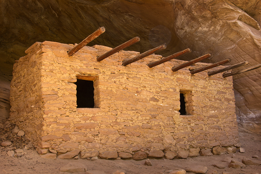
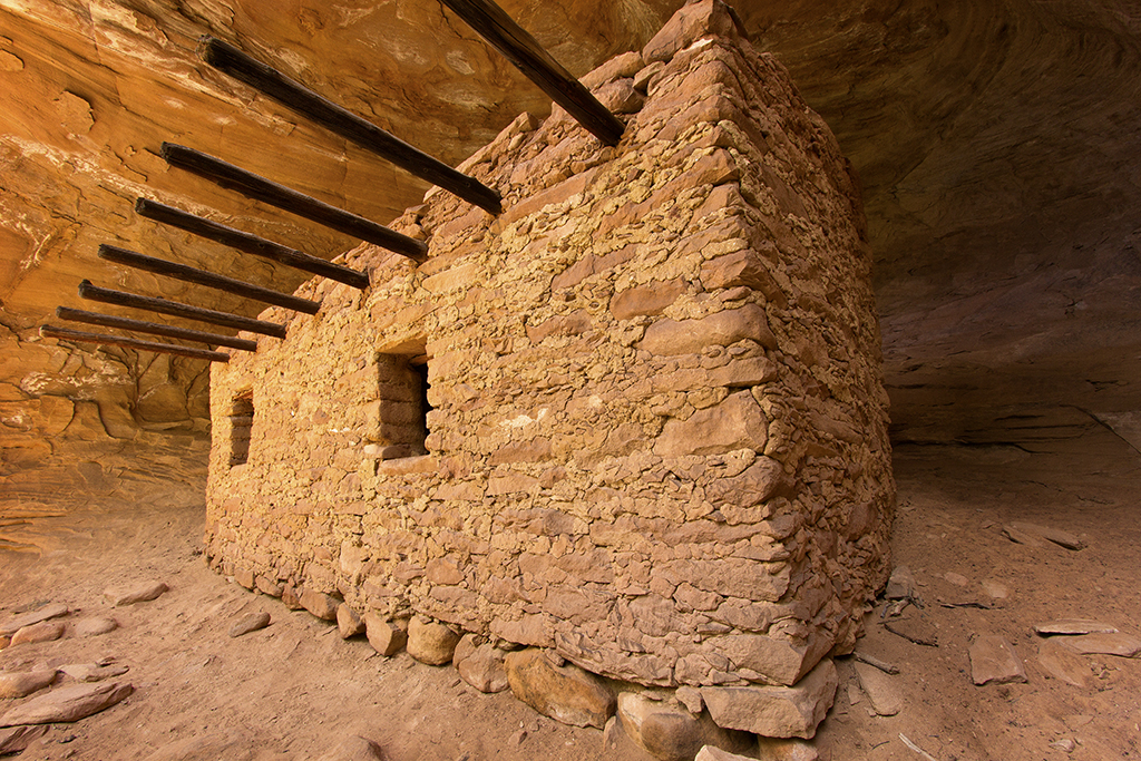
Late the afternoon of Wed. July 17th I picked up my old friend Tim on the way out of town. Our destination, the Henry Mountains. But due to the late start, we wouldn’t make the Henries before dark, so set our sights on a spot near Goblin Valley that we call Hippy Camp. Tim and I have been running around together doing this kind of stuff for over 30 years now. Hippy Camp got its name about 20 years ago, the second or third time we rolled in there to crash for the night. That night, we rolled up to find half a dozen hippies encamped there, complete with a huge bonfire and a Microbus. All obviously stoned out of their minds – on something more potent than weed... We bailed and found somewhere else to crash that night. Next time we used the camp, a year or two later, we found all kinds of spirals and peace signs and weird symbols laid out with small stones all over the area.

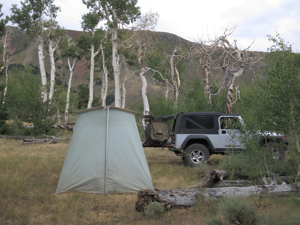
Anyway… Hippy Camp is only a few hundred yards east off the road to Goblin Valley, but out of sight of the road and well protected from prevailing winds. Interestingly, I found a couple trippy spiral designs that looked fairly recent on this visit, so apparently the hippies still use it too after all these years. But other than the one time it earned its name, we’ve never run into anyone else there in the times we’ve used it over the past 20 years. It’s a great spot to pull off and crash while coming and going through the area. And so, that is where we threw out our cots and sleeping bags in the moonless dark night to catch some Z’s.

Thursday morning I was up well before daylight, stashing my sleeping bag and cot in the Jeep while boiling water for coffee. I sipped that first cup in silence, marveling at the inky blackness of the pre-dawn following a moonless night. Noting the occasional “woosh” of a bat or night bird flitting around my head, too dark to tell what it was. By the time I had a second cup brewed and the stub of the previous nights cigar lit, the first hints of light were starting to show in the direction of Robbers Roost and The Maze. I gave Tim’s cot a shake with my foot and told him it was time to roll. He was up and had his gear stowed in no time and we were gassing up in Hanksville when the sun first appeared on the horizon.

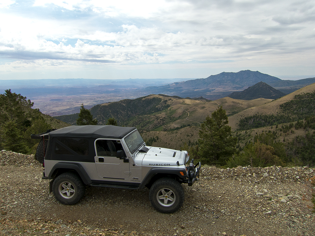
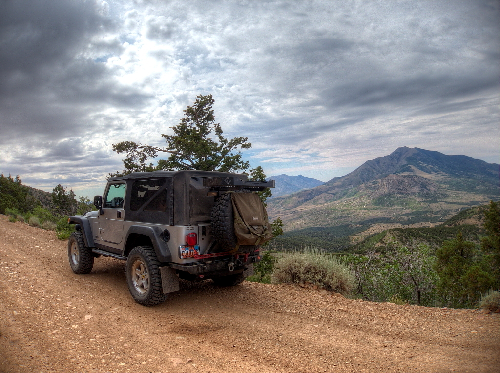
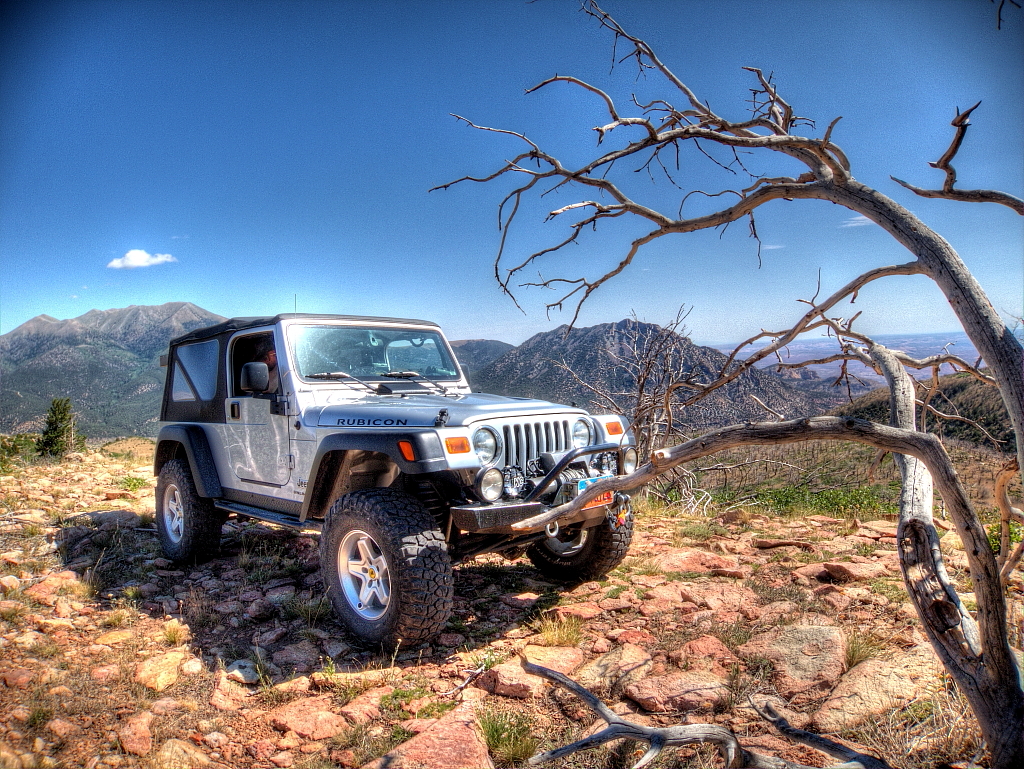
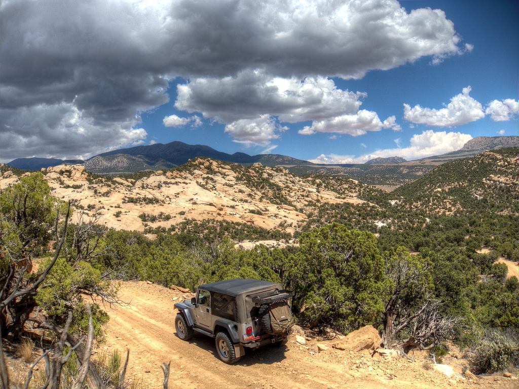
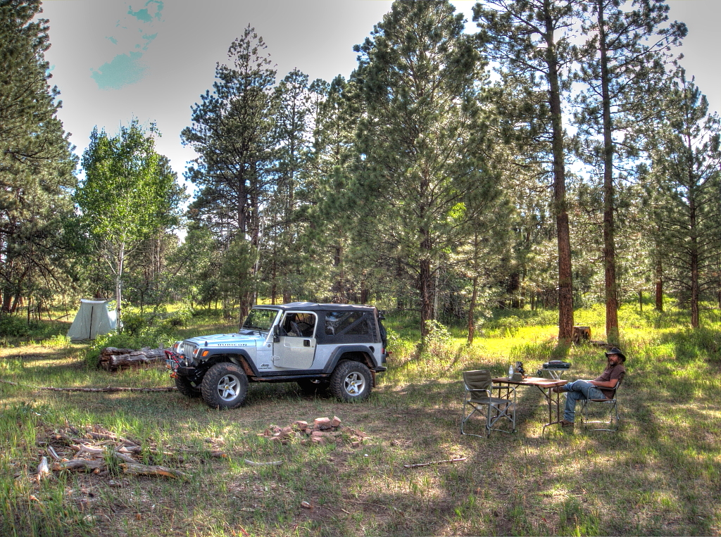
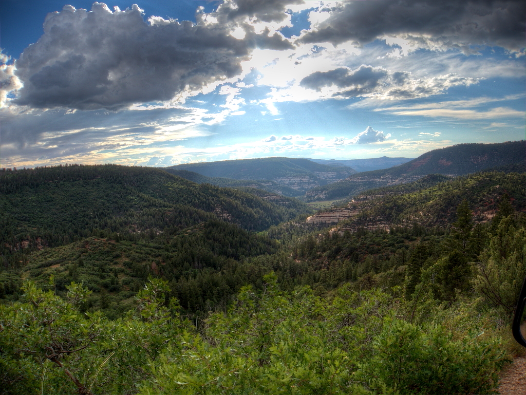
After fueling, we took a left at the Post Office and rolled south on the Sawmill Basin road, up past Bull Mountain, to Lonesome Beaver campground where we stopped just long enough for me to pull out the JetBoil and whip up another cup of Italian Roast, which I laced liberally with Baileys before lighting a fresh cigar with which to face the fresh day. Lonesome Beaver was indeed lonesome – totally deserted, and not of interest to us anyway, so onward and upward we went. Leaving the Hellish heat of the July desert behind and relishing the coolness of the fresh, crisp, pine scented mountain air.

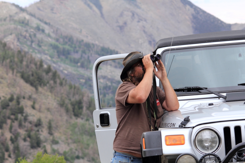
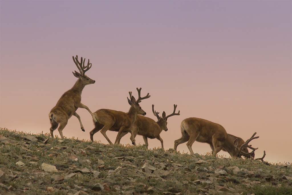
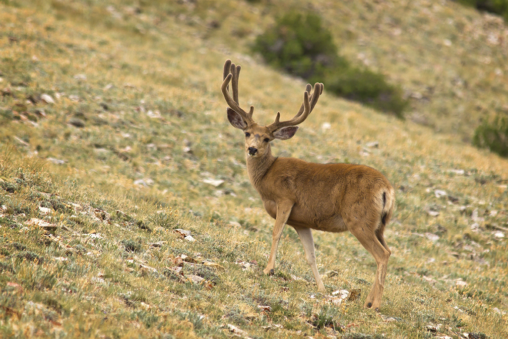
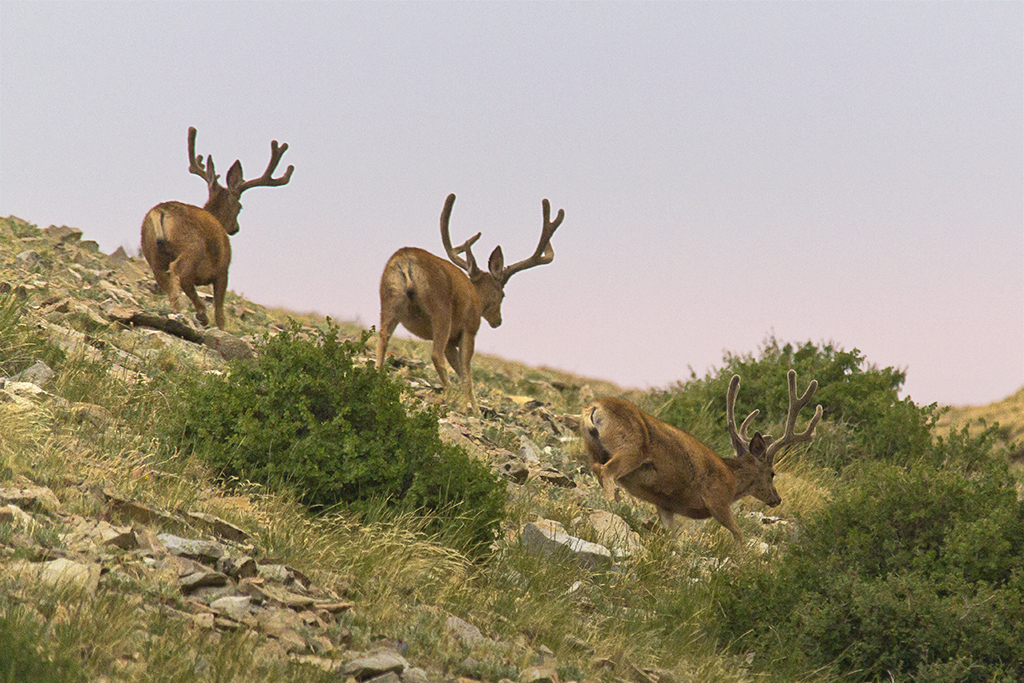
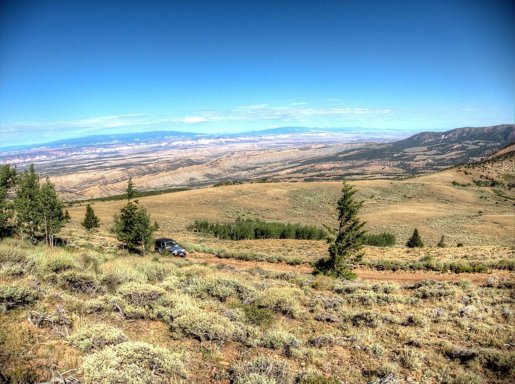
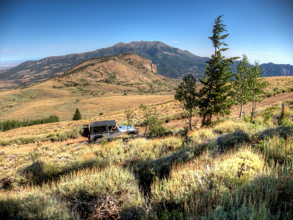
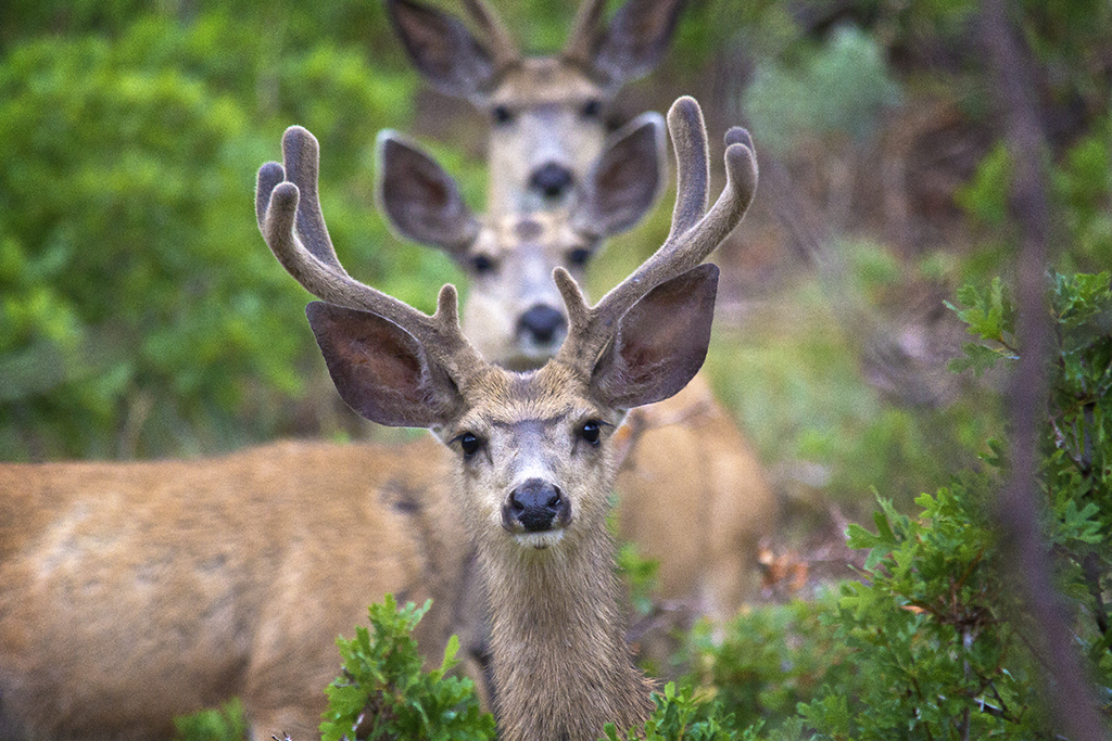
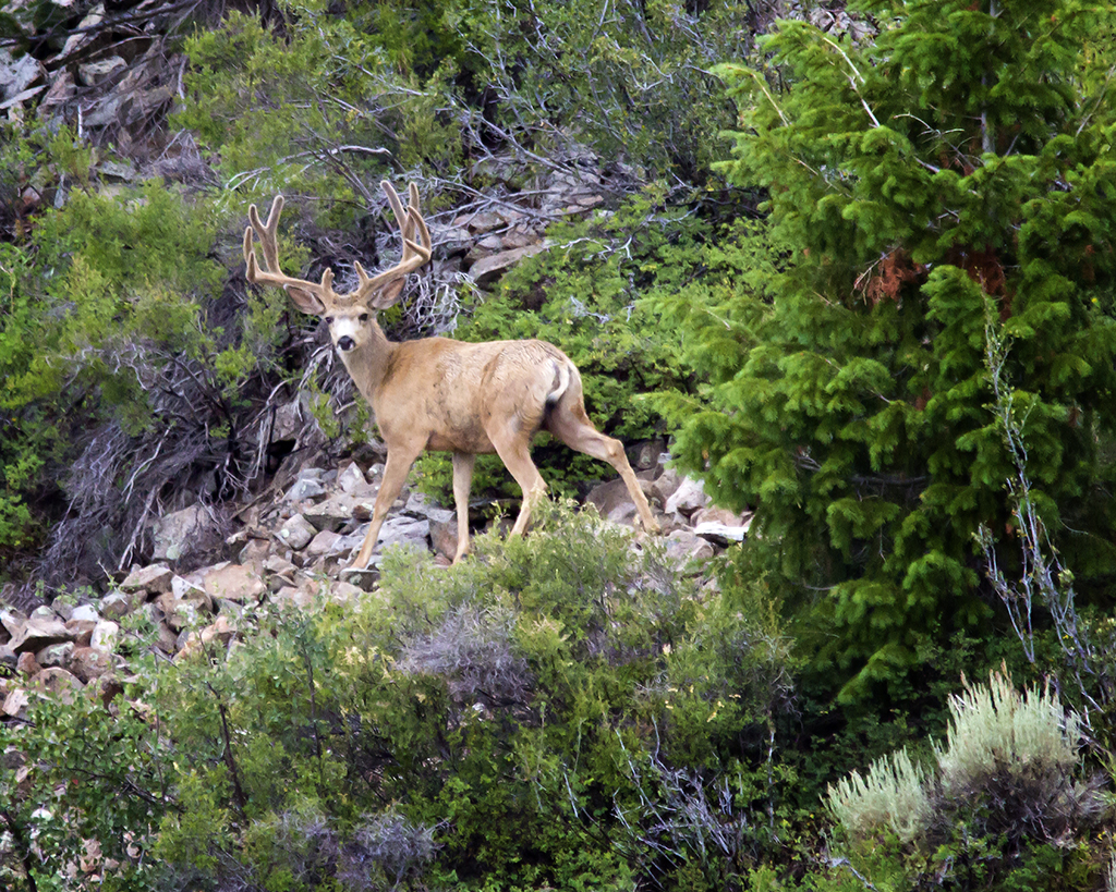
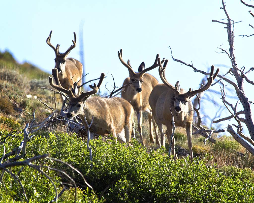
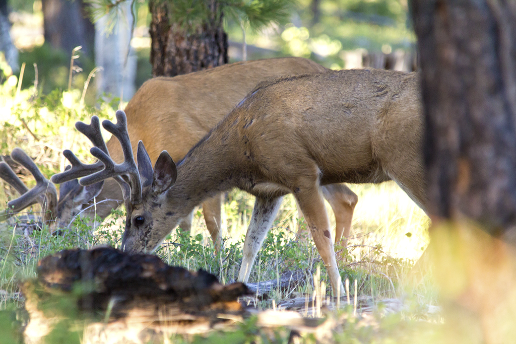
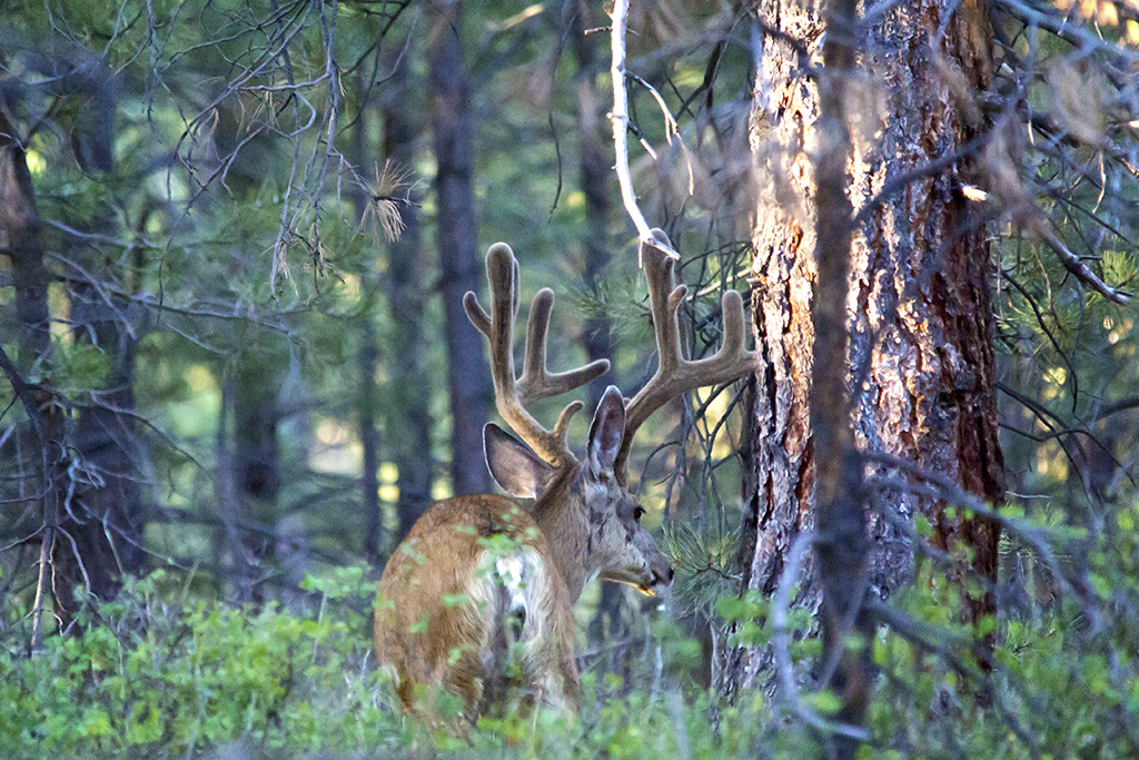
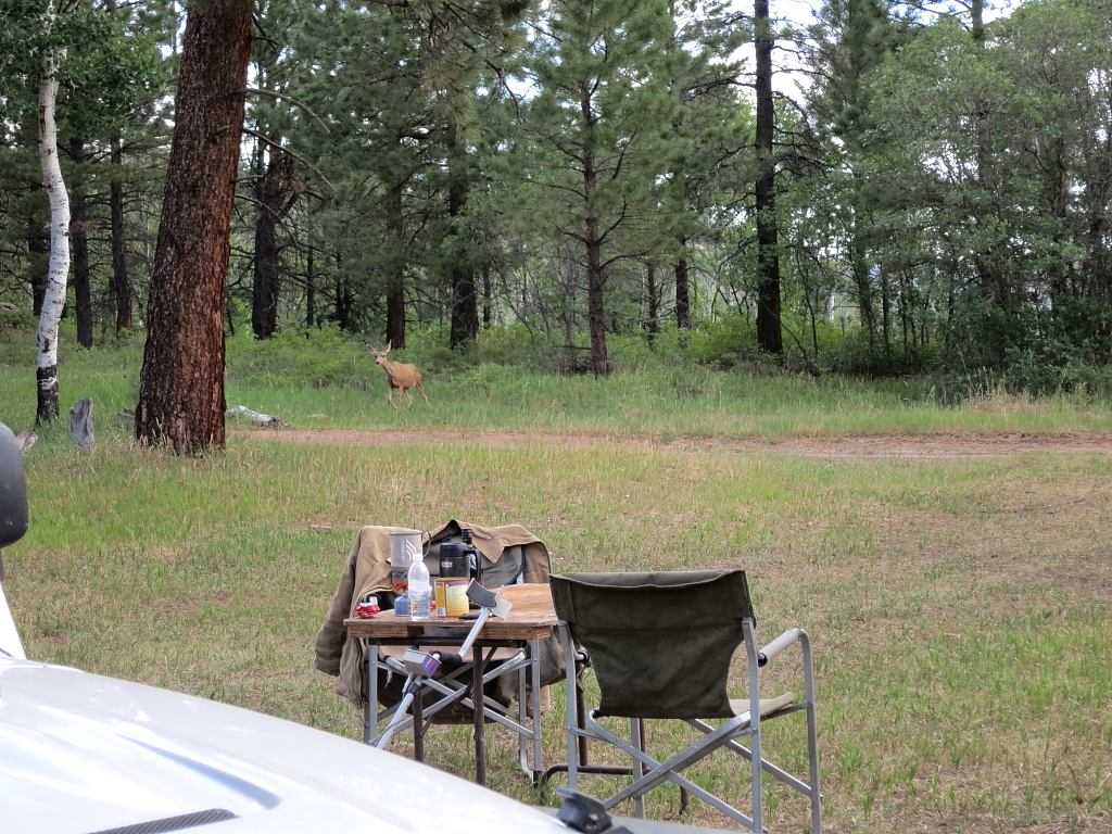
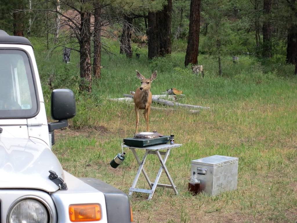
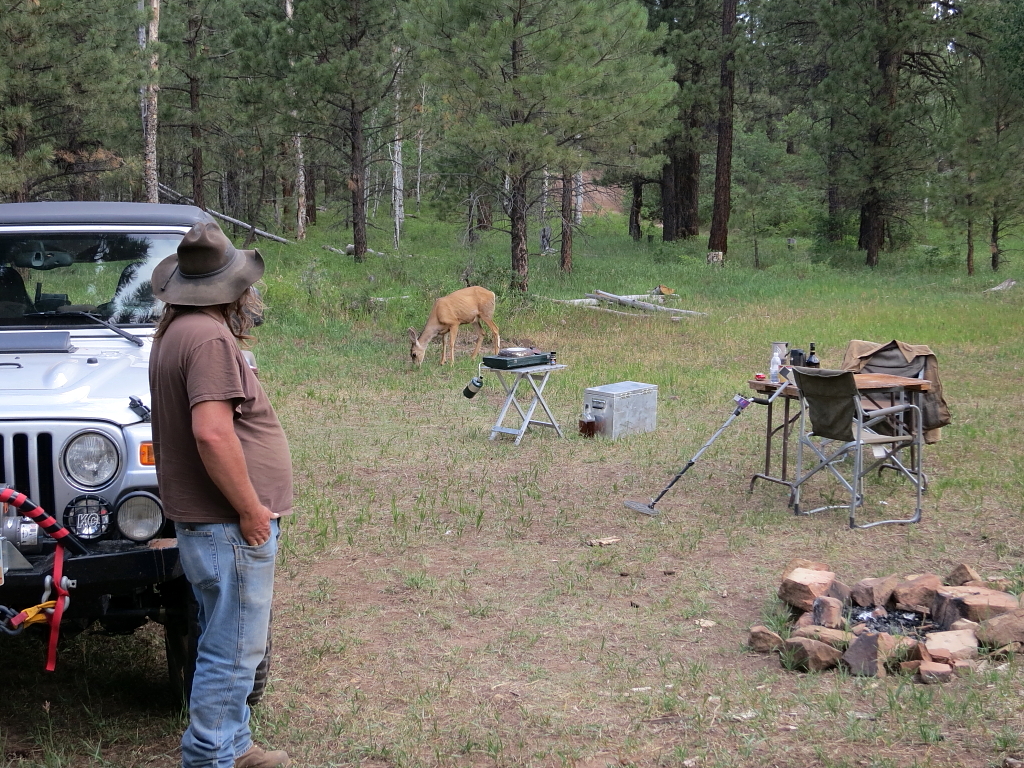
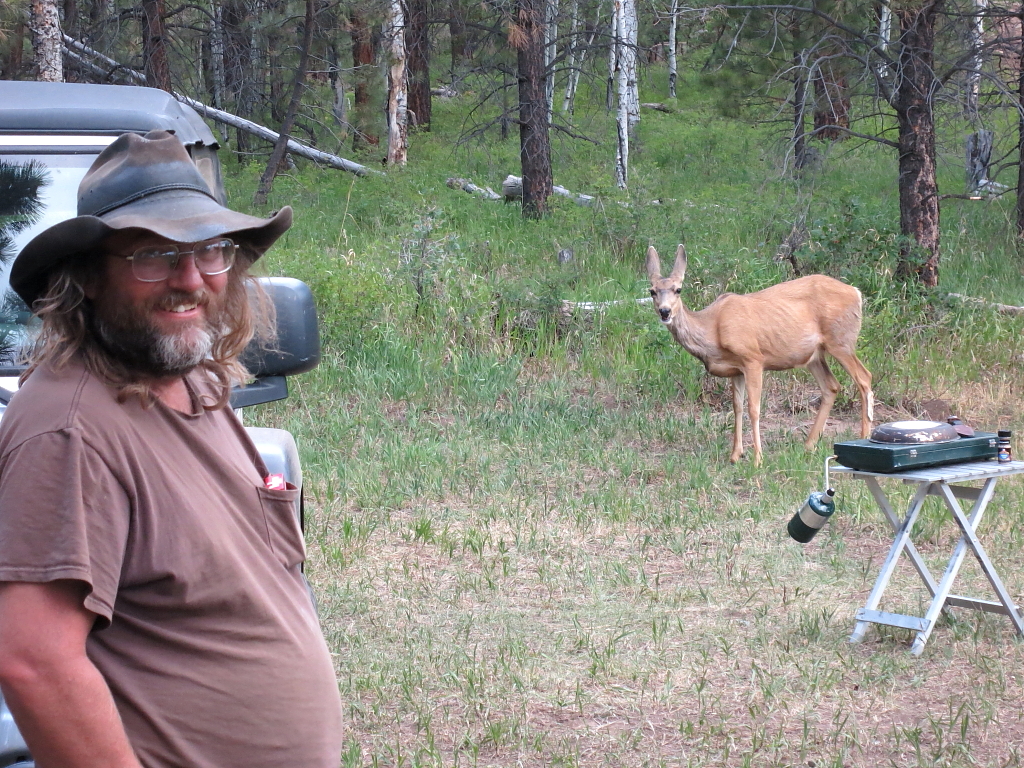
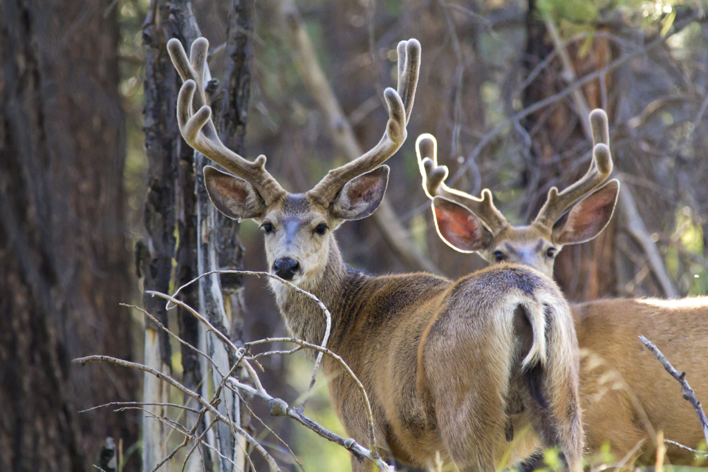
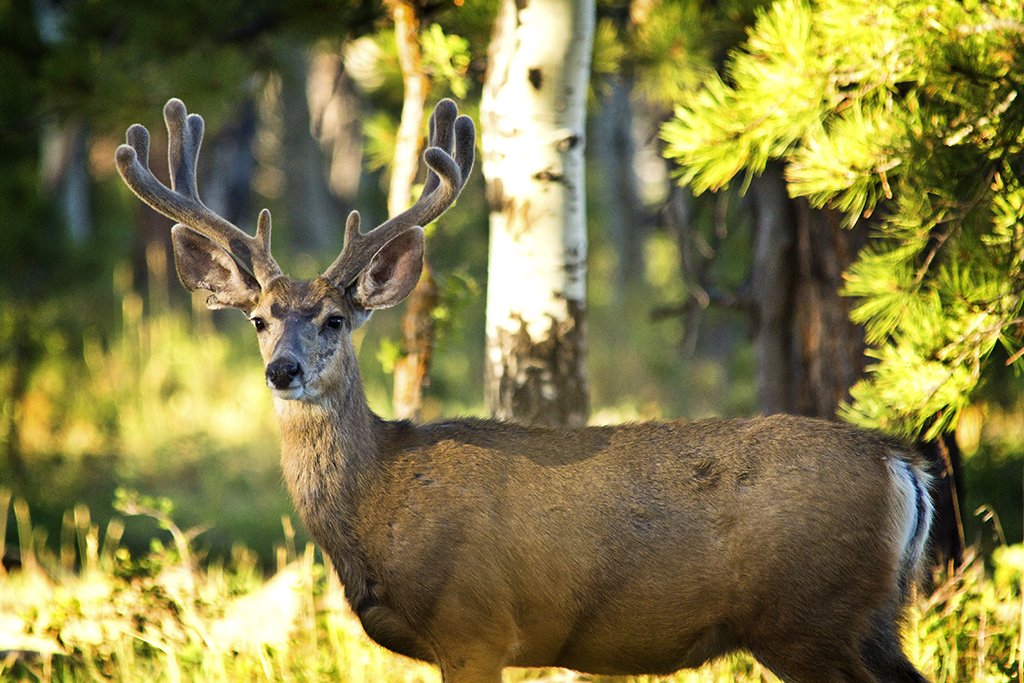
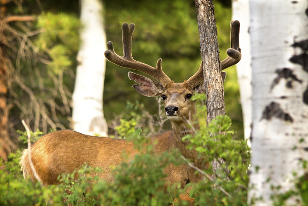
We had no plans for the next four days. We wanted to see some deer, I wanted to try and get some decent pictures of them, we thought it might be cool to wash a few gold pans of gravel out of Crescent creek just for old times sake. But basically, we were just there to see what we could see and no particular itinerary for where to go each day or plans for where we should end up each night. Free to wander, just like the old days when the world was young and we had no more responsibility than a pair of hoboes.

More...

Featured image for home page:
slide.jpg
 
From Lonesome Beaver we ascended Wickiup Pass. At the top, it was obvious we should go southwest towards Bull Creek Pass, as going southeast towards Granite Ridges would put the morning sun right in our eyes.

As mentioned, the only real goal for this trip was to see and photograph mule deer. We started getting that out of the way immediately! We stopped numerous times to observe and try to photograph nice bucks before even reaching Bull Creek Pass. And that would be the theme for the rest of the morning – drive along slowly looking for deer, see deer, stop to glass and/or photograph, get back in the Jeep and repeat.

IMG_2464W.JPG


Here are just a few of the dozens of buck we saw that morning:

2556CW.jpg


IMG_2389W.jpg


IMG_2576.jpg


More...
 
This continued all the way around the Mount Ellen road until we reached the southeast side of Kimble and Turner Peak, where a sign indicates a road to Bromide Basin. The last time Tim and I had visited the Henries, 20-something years ago, we had taken a gnarly Jeep trail into Bromide Basin, in my ’74 Chevy ¾ ton. We both remembered putting some pretty good dents in the truck, negotiating a twisty narrow Jeep trail up to Bromide. But this road looked super easy. So we took it! But not very far… It ended at a signed gate for the mining company working the Bromide Mine.
Part of the mine operation visible from the trail on a nearby ridge top.

IMG_0380W.JPG


Copper Ridge, near the sign for Bromide Basin

IMG_0378W.jpg


From there we continued our circumnavigation of Mt. Ellen northward until reaching Crescent Creek. Here, even though it looked in much better shape now, we both recognized the trail we had taken to reach Bromide Basin many years earlier, so turned to go up it. But, again, not very far before hitting a No Trespassing sign by the mine company.

So, we turned around and drove down Crescent Creek for quite a few miles, checking out the site of the Eagle City ghost town and old placer mining operations and junk along the way. When we got clear of the patented mine property that was posted, we hoped to try our luck with a little gold panning. But, this late in a dry year, we found the creek bone dry. So, no panning this trip. Maybe next time. It was fun just driving the obscure side tracks and looking at all the old buildings and equipment anyway.

A few pics from the area…

IMG_0391W.JPG


IMG_0393_4_5W.JPG


IMG_0387_W.JPG


More...
 
Then it was back up in elevation to continue our circumnavigation of Mt. Ellen, with a stop at the Granite Ridges to woof down some cold fried chicken for lunch. After lunch, we continued around to Wickiup Pass again, completing our first loop of Mt. Ellen. From there, we bombed around to the west side once more to set up the tent at Nasty Flat.

IMG_0412W.JPG


Following a simple dinner of brats and chili, with cheesecake for desert, we spent a little time driving down to McClellan spring, but all we were seeing down lower were does and fawns, so we headed back up to Mt. Ellen and worked our way down towards the south end, repeating our routine of the morning, driving slowly, glassing deer etc. The numbers of big buck that came out and were visible just before dark was amazing! Never, in all my years, have I seen so many 24”+ mule deer buck at one time. It was way cool!

We got rained on HARD that night. The wind howled too. But, the old Springbar shrugs off rain like nothing. Tim says it kept up like that for hours. But for me, rain on the tent is like riding a bus – I can’t stay awake. So I slept so good I had no idea!
Up with the dawn on Friday morning, we broke camp and again did another full circumnavigation of Mt. Ellen just looking at deer, and again, we saw a bunch! It was a blast. When we got back around to the south end for the second time that morning, we took the turn south from Copper Ridge towards Pennellen Pass, The Horn and Mt. Pennellen.

Heading towards The Horn and Mt. Pennellen.

IMG_0370_1_2W.JPG


Looking northwest from the side of Mt. Pennellen, with Water Pocket Fold in the middle distance and Mt. Ellen showing on the right.

IMG_0435_6_7W.JPG


Looking at The Horn, with Kimball and Turner Peak behind it.

IMG_0438_39_40W.JPG


More...
 
We drove all around the Horn and as far south as we could on the west side of Pennellen. We didn’t see nearly as many deer as we had on Mt. Ellen, but we did see some. Here are a few of them.

IMG_2593W.jpg


IMG_2617W.jpg


IMG_2702W.jpg


By lunchtime, we had driven every open navigable road on the south and west sides of Pennellen, ending up having lunch where the road going east from above The Horn dead ends, here.

IMG_0462_W.JPG


After lunch, we decided to drop down off the mountain towards Water Pocket Fold and just goof off for awhile, watching the world go by over the hood of the Jeep. One of the first stops along the way was at Airplane Spring, the name of which is explained by this historical marker at the site.

IMG_0471W.JPG


Eventually we ended up way out on the southwest end of Tarantula Mesa, where we hiked around for awhile looking for arrowheads and such. Found some scant lithic scatter, but that’s about it. Oh, and a gopher snake {grin}. Some of the sights from Tarantula Mesa.

IMG_0484W.JPG


IMG_0488W.JPG


IMG_0493_4_5W.JPG


IMG_0516_7_8W.JPG


And some cool rock art inside a hollowed out boulder encountered during our travels.

IMG_2342_3_4WW.JPG


More...
 
From Tarantula Mesa we retraced our path back to Pennellen Pass, around the north side of The Horn and over to the east side of Mt. Pennellen. We were looking for somewhere to throw out the tent for the night, and maybe some good spots to look at deer that evening. Tent spots were scarce! And believe me, we are NOT picky! We did pass up a couple marginal spots, and one “okay spot”, before finding the best camp spot in the entire area. Unfortunately, everyone else had already found it too and it was way too crowded for our tastes – there had to have been like two or three people there. So we retreated to the “okay” spot near Gibbons Spring.

We had lost about 1,500 feet elevation compared to our camp the previous night and it showed in the difference in vegetation and temperature. Instead of quakies, pines and chilly air, we had scrub, PJ’s and it was downright hot! Thinking we probably wouldn’t need a tent, we didn’t put it up right away.

Tim took a nap and I took a hike. I found TONS of lithic scatter in the area, and a few truly ancient fire rings – one so old the rocks were barely showing above the soil and vegetation was growing in it with no hint of charcoal showing. Judging by the lithic scatter all about and the two hammer stones I spotted, it was a hearth of the ancients no doubt.

When I got back to the Jeep I woke Tim up and asked him if he really felt like hanging out in the heat and the scrub all afternoon waiting for evening. Yeah, neither did I… Nor did I feel like going back to Mt. Ellen, we’d done that to death the last day and a half. Hey – let’s bail out of here completely and motor for Elk Ridge! So, we did…

Down the Coyote Benches, around Farmers Knob, down Trachyte Creek to Hwy 276, north to Hwy 95 and then motoring south towards Hite to get some gas. We were tooling along happy as clams just south of Hog Springs when a rig towing a big boat went past going the other way. Just as it approached I caught something out of the corner of my eye coming from their rig towards mine. I had just an instant to start to turn my eye towards it and Ka-SLAAAAAM!!! My driver side window exploded all over me! I do not know what it was that came off the other rig and hit me – don’t know if it was something thrown out the window or something came loose off the boat or a lug nut or what the heck. But it sure broke the crap out of my window!

IMG_0527W.JPG


IMG_0525W.JPG


Luckily, I was none the worse for wear. I had a few small cuts on my left arm and my cheek, but that’s it. Glad I was wearing sunglasses! The rest of the trip, another 550 miles, would be driven sans window. I just hung a garbage bag over it at night when it rained, but left it open driving.

More...
 
From there it was a quick gas stop at Hite (we noticed the flag at half mast and wondered who had died, had no idea about the Colorado shooting). Then on to the Maverick Point road, between the Bears Ears and on to Elk Ridge. We made it all the way up on top in time to look at a few deer before putting up the tent in a nice spot.

IMG_2808W.jpg


IMG_2775W.jpg


IMG_0568_W.JPG


Dinner that night was cheeseburgers and fried potatoes, with cheese danishes for desert. The fire ban was still in effect, so I sat up for awhile after dinner, just listening to the dark, sipping my Irish and puffing a nice Fuente cigar.

Up at first light the next morning, we left the tent in place – intending to stay there a second night. Staying in the same place two nights in a row is an exceedingly rare occurrence for us. We both thought about it and neither of us can remember the last time that Springbar sat still for two nights in a row. I know that tent has conservatively well over 300 nights of use (probably closer to 400) and I bet only 3 or 4 times has it ever stayed in the same place two nights in a row.

Anyway… With a spectacular beautiful morning busting out all around us, a big mug of hot coffee and baileys with a fresh cigar to puff on, we just put-putted up the road looking at deer for the morning. And, as usual, we saw a few! As the morning wore on and we started seeing fewer and fewer buck, we decided to take a little sight seeing trip. So, we drove about 25 miles to another nearby mesa to visit a pristine Anasazi ruin.

IMG_2848_W.JPG


IMG_2866W.jpg


IMG_2887W.jpg


More...
 
From there it was back up onto Elk Ridge. It was at this point we decided to drive the Dark Canyon Corridor.

IMG_0554W.JPG


So, down into Peavine we dropped, and it was way cool! Way cool, until… This:

IMG_0557W.JPG


Ruh-roh… Bottom of Dark Canyon, broken track bar…

Used ratchet straps to stabilize the axle.

IMG_0562W.JPG


And got turned around and limped it back about 9 miles up out of the canyon. As soon as we got back to the trail head, I turned on my phone and was pleasantly surprised to have a good signal. So I called my buddy Steve back in Salt Lake, told him what was up, and he agreed to go get my spare track bar from my house and bring it down and meet us in Blanding the next morning.

With that settled and nothing more to be done about it, we limped the Jeep back to camp and hung out for awhile.

More...
 
There had been a doe hanging out near camp the whole time we had been there. You can see her in the background here.

IMG_0571W.JPG


Something kind of funny happened with that doe while we were hanging out in camp Sat. afternoon. My buddy Tim walked over behind the Jeep and took a leak. He says that doe watched him like a hawk while he was pissing. Then, as soon as he walked away, the doe quickly walked over and ate all the grass he had just pee’d on! Photos to follow…

IMG_0576W.JPG


IMG_0579W.JPG


Hmmm… Tim’s urine tastes great on grass! LOL!

IMG_0580W.JPG


We got kind of bored sitting around camp and decided that if I went real slow, we weren’t going to hurt anything putting up the road looking at deer for the evening, so that’s what we did. Some of the sights from that evening along Elk Ridge…

IMG_0583_4_5W.JPG


IMG_2829W.jpg


IMG_0604_5_6W.JPG


IMG_2815W.jpg


IMG_2909W.jpg


More...
 
Despite the broken window and the broken track bar, the trip had been a roaring success and just too much fun. So, dinner that night was a celebratory one. Rib eye steaks, collard greens, potatoes and triple layer chocolate fudge cake for desert. Yum-yum!

Up early again on Sunday morning, we packed up camp and started the long slow drive down into Blanding on a broken track bar. Steve and Jen were going to meet us there about 11am. So we had a looong time to get there. Which was good, because I wasn’t going very fast on a broken track bar (left turns were a real problem...). It was actually quite enjoyable, just putting along down the dirt road at about 12 MPH, sipping coffee, smoking a cigar, taking in all the sights, smells and sounds of the mountain.

We stopped along the way to take a quick peak at the Over-Under ruin.

IMG_0619_20_21W.JPG


IMG_2928W.JPG


IMG_2932W.JPG


The fun pretty much ended when we hit pavement though. Putting down a dirt road at 12 MPH is great, doing it on Hwy 95 sucks… All in all, the route we took ended up being about 50 miles and took us a solid 4 hours to get to Blanding. But, it worked out almost perfect as we only had to wait about 15 minutes before Steve rolled up with my factory track bar and an air hammer to knock the broken stud out of the frame mount. It took us not more than 20 minutes in the parking lot of the Visitors Center to get the factory bar swapped in. Thanks Steve – love ya Brother!

Then it was a pretty smooth roll all the way home – stopping in Moab for lunch at Zax and dodging rain storms the whole 300 miles home without a driver side window.

Another adventure in the books!

- DAA
 
Great report. I can see the Henrys from my house but it's been several years since I've been up there, must rectify.
 
Similar threads
Thread starter Title Forum Replies Date
ANelson Hiking to the Top of the Henry's (Mount Ellen) August 2022 Hiking & Camping 10
Perry Henry's Fork Basin - Camp Site Suggestions Trip Planning 3
norwegianxplorer In the shadow of the Henry Mountains, Utah Backpacking 2
DrNed Red Castle Kings Peak Henry's Fork Take Two Backpacking 8
powderglut Camping By the Henry Mts, Slots, and Cedar Mesa Ruins Hiking & Camping 9
DrNed Upper Henry's Fork Lakes Trip Planning 1
Tystevens Henry's Fork -- Red Castle loop from China Meadows Backpacking 2
westy High Uintas - Henry's, Painter, Yellowstone, Smith's Backpacking 5
DrNed Henry's Fork - King's Peak Backpacking 17
Brett King's Peak Loop from Henry's Fork TH Trip Planning 10
ogg California, Henry W. Coe State Park, Father-Daughter Backpacking 3
Tye Dye Twins Henry's Fork (3 day Uintas trip) Backpacking 13
Janice San Juan Mtns - late June too early? Trip Planning 4
J Mojave Natl. Preserve: Midhills to Castle Mtns Nov. 26-28, 2021 Hiking & Camping 2
J Death Valley Natl. Pk. A Black Mtns and Canyons Traverse Nov 30, 2021 Hiking & Camping 2
J Grenadier Range, San Juan Mtns. Weminuche Wilderness, CO June 27-30, 2007 Retro Backpacking 9
Bob ALERT..... 9/22/18... Windrivers mtns Trip Planning 6
ogg Backpacking Ruby Mtns or Great Basin NP Trip Planning 9
Kullaberg63 Mt. Tukuhnikivatz to Gold Basin loop, La Sal mtns. Hiking & Camping 5
Bob Wind River Mtns - Osborne Mtn Fire Photography 1
HomerJ Deep Canyon - Wellsville Mtns Hiking & Camping 3
Tweedie Weminuche off-Trail from Elk Park to Needleton 2023 (Via Vestal, Balsam, Noname and Ruby) Backpacking 15
M 5 days Green > Elk Wind River route advice August 17th Trip Planning 9
SteveR Blueberry Hill and West Elk Pass, Alberta Winter Sports 1
NorthwestWanderer Olympic National Park - Elk Mountain Hiking & Camping 7
F Elk vs Fence General Discussion 2
TeamJenkins17 Black bear killing baby elk Photography 0
tomcat32 Backpacking the West Elk Wilderness Backpacking 9
P Elk and the Absaroka General Discussion 1
blueeyes Island Park, ID to Elk Lake Lodge, MT Bikepacking Trip July 14-15 2015 Everything Else 12
someguy Big Elk Lake Backpacking 5
IntrepidXJ Fall Colors in the Elk Mountains Hiking & Camping 5
Laura Be careful of testosterone-fueled elk General Discussion 1
IntrepidXJ Fall Colors in the Elk Mountains Off Road 4

Similar threads

Back
Top