Keith
Member
- Joined
- Nov 2, 2014
- Messages
- 75
I was recently in Yellowstone with my wife, son and his friend. We visited various historic sites in the woods, Turbid Lake, Heart Lake and Mount Sheridan.
Day 3: It’s July in Yellowstone so we have to worry about hypothermia! It was time to leave the crowds behind and get into the woods. We were headed to Heart Lake. Our campsite was about 9.5 miles which is about my ideal max carrying a loaded backpack. We got our permits at the Canyon VC where we met some very cheery rangers. Their educational video was busted so they quizzed us on backcountry rules. We listed for them all the places we had camped in the backcountry so they let us go without too much fanfare. One was downright hilarious talking about and mimicking golden eagles. We laughed so hard we nearly cried. At the trailhead we met a nice couple from St. Louis (my home town) which were making it a day trip. The day started off very nice so we decided to reduce our load and not pack rain pants. Big mistake. Never again will I be fooled by sunny weather in Yellowstone (I’ve now said that 3 times in my lifeJ and been very wrong). The boys headed out before us – they have bigger packs and stronger backs and can just throw all their stuff in whereas Kristin and I have to be a little more methodical. The first 5 miles is a little uphill and offers a variety of woods and meadows. The longer we hiked the more ominous the clouds became. We ran into a ranger about an hour in and he didn’t want to stop us to check our permits – he was clearly worried about the weather and us making it into camp before the rains hit. After about 1 hour and 45 minutes we reached the opening where the thermal features start and you can see Heart Lake.
.jpg")
.jpg")
.jpg")
.jpg")
.jpg")
.jpg")
.jpg")
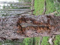
Things started going south from there. As we hiked down the hill the rain and wind hit us hard. We heard 3 trees collapse in the wind. They were burned trees but it was still pretty impressive to hear. We saw one that kicked up quite a dust storm so that was cool. By the time we reached the patrol cabin we were already pretty wet (we did fortunately have very good rain jackets on). The couple from St. Louis was huddled on the porch of the cabin. They had made the same assessment of the weather we had and only had shorts and jackets. Kristin and I had another mile to get to our campsite (8H2). The wind was blowing cold and hard off the lake, it was raining hard and the grass was tall and soaking wet. I was yelling at the weather hoping Kristin didn’t hear me. I just wanted to get her in a tent and dry her off. I had a near hypothermic experience last July bushwhacking down the Ferris Fork from the Pitchstone Plateau but it’s different when you have family in that situation. I know the sun will always come out eventually in Yellowstone so I persevere but it’s different when family is in harm’s way. We finally reached our campsite and were able to set our tent up in the rain. It was a new tent that I figured I would learn to set up on site. Again, not a great decision but we managed without too much hassle. We got in, changed clothes, got in our sleeping backs and then it got really exciting. Lightning, thunder, more wind and then hail. The wind was blowing so hard the tent walls were hitting us. I was just hoping the tent would hold and it did great so big relief. I can’t imagine what hiking in that hail would have been like. I’m guessing the couple didn’t make it back to their cars in time. The boys got there about 2 hours before us and had managed to setup their tent before getting rained on too much. There were enjoying the thunder and hail. I was just hoping our new tent would hold up and Kristin would survive! We didn’t eat dinner that night. The boys got out briefly to collection firewood -- they were hoping to get a fire going so we could all warm up but the hail dissuaded them")
Day 4: We woke up the next morning and our spirits were pretty low. It was still very cold and it was difficult to tell if the clouds would break for our climb up Mount Sheridan. I have found that when in the woods and feeling down, it’s best to just eat and warm up before making any big decisions. We did eat and that lifted our spirits but getting warm was still a problem. We also watched a pair of sandhill cranes fly by and I love the sounds they make so that lifted my spirits more. There was a mix of sun and clouds but we could see the lookout from our camp site.
.jpg")
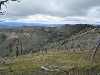
The boys and I decided to attempt Mount Sheridan and just turn back if it started to rain. Kristin needed more time to recover from the previous day and decided to stay at camp, read and enjoy the scenery. The climb up Mount Sheridan is 3000 feet over 4 miles. It’s really more like 2000 feet over 2 miles with the first two miles just there to annoy you. After about 600 vertical feet we started to see some cool views.
.jpg")
.jpg")
.jpg")
.jpg")
.jpg")
.jpg")
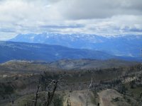
It was getting colder but it wasn’t raining so we pressed on. There are some pretty intense switchbacks and the whole time we could see the lookout on top but it just never seemed to get closer. I noticed an I-Blaze at one point which I found interesting (and would interest Hugh as well but probably nobody else J). The hike is beautiful and the scenery just gets better the higher up you go. We soon could see Lake Hotel in the distance and then other features such as West Thumb, Delusion Lake and the Thorofare. About 1000 vertical feet from the top (about a mile to go), it started to snow on us. It was just a little but I can now say I’ve been snowed on in Yellowstone in 6 different months (February, May, June, July, September and October).
.jpg")
.jpg")
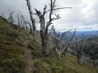
The trees near the top were still covered in the hail from the previous day. As we reached a ridge we lost site of the lookout. It was even colder on that side but we pressed on. We were generating enough heat to keep somewhat warm but I could feel my hands and arms getting pretty chilly. I was also pretty exhilarated by the views of the Tetons and Pitchstone Plateau.
Pitchstone Plateau:
.jpg")
The snow/hail on the trees was interesting in that it accumulated only on the east side.
.jpg")
.jpg")
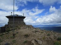
We rounded the corner and the lookout was back in site and actually looked close! We made our final assault.
.jpg")
.jpg")
.jpg")
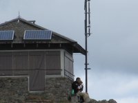
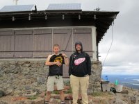
Colin is a bit of a Mountain Goat so he had been there awhile already waiting for Jamey and me. I actually saw him running at one point uphill at 10,000 feet. His dad is a pilot so I think high altitude is in his blood. We spent about 30 minutes at the top. We found the bathroom, picnic bench and enjoyed the views. We could see my new tent in the distance so we tried shouting to Kristin but it was pretty futile given the distance and the proximity of the campsite to a creek.
360 degree view:
The clouds were a little too low to find Washburn, Avalanche, Holms and Electric with great certainty but Lake Yellowstone was in clear view (as was Pitchstone Plateau, the Tetons, and Delusion Lake). I wanted to stay longer but there was no shelter from the wind and I was still worried about rain.
West thumb in the background:
.jpg")
Heart Lake:
.jpg")
Lake Hotel in the distance (and perhaps Delusion Lake?):
.jpg")
Flat Mountain Arm (I think):
.jpg")
South Arm and The Promontory:
.jpg")
The Southeast Arm:
.jpg")
West Thumb: Is that Riddle Lake?
.jpg")
On the way back down we all went at our own pace.
.jpg")
.jpg")
.jpg")
.jpg")
.jpg")
I found more I-Blazes which I hadn’t noticed on the way up because I was too busy trying to breathe.
.jpg")
.jpg")
The clouds cleared enough to identify Washburn (I think – you be the judge).
.jpg")
I came across a ptarmigan that didn't want to surrender the path:
.jpg")
We all made it back to camp and reconnected with Kristin, ate, enjoyed some fire and went to bed.
.jpg")
Day 5: It was time to pack up camp and hike back to civilization. The sun was out just in time for the big hike back up the hill to car – great timing for hot weather
.jpg")
One more pit stop before heading out:
.jpg")
Last view of camp:
.jpg")
The boys headed out first as usual and Kristin and I waited for the grass to dry before we took off. I got some good pictures of the camp site and the lake and we trudged back up the hill. The weather is always best when leaving. It was pretty grueling getting back up the hill but we managed with a few stops.
.jpg")
.jpg")
.jpg")
.jpg")
We came across one grumpy guy who didn’t like us drying our shoes and socks in the trail during a rest stop because his horses were coming through any minute. Turns out we never saw the horses but we did increasingly run into more happy people heading down the hill barely wearing anything. There is nothing worse than happy people going downhill when you are going uphill and the difference in weather they were experiencing compared to us 2 days earlier making the same trip down irritated me as well. We came across a ranger trying to clear the trail with an axe. He was hoping the horses would show up soon because they often carry chainsaws with them. He checked our permits – no weather concerns today. As we approached the trailhead I told Kristin this is when I start to panic that I’ll get bad news after being out of contact for a couple days. It was a little too prophetic this time, we got some distressing news. It was nothing life threatening, but my wife had to cut short her trip to Yellowstone short to meet our daughter who was cutting her trip to Europe short. It just reaffirmed to me that bad news could always be waiting at the trailhead.
Featured image for home page:

Day 3: It’s July in Yellowstone so we have to worry about hypothermia! It was time to leave the crowds behind and get into the woods. We were headed to Heart Lake. Our campsite was about 9.5 miles which is about my ideal max carrying a loaded backpack. We got our permits at the Canyon VC where we met some very cheery rangers. Their educational video was busted so they quizzed us on backcountry rules. We listed for them all the places we had camped in the backcountry so they let us go without too much fanfare. One was downright hilarious talking about and mimicking golden eagles. We laughed so hard we nearly cried. At the trailhead we met a nice couple from St. Louis (my home town) which were making it a day trip. The day started off very nice so we decided to reduce our load and not pack rain pants. Big mistake. Never again will I be fooled by sunny weather in Yellowstone (I’ve now said that 3 times in my lifeJ and been very wrong). The boys headed out before us – they have bigger packs and stronger backs and can just throw all their stuff in whereas Kristin and I have to be a little more methodical. The first 5 miles is a little uphill and offers a variety of woods and meadows. The longer we hiked the more ominous the clouds became. We ran into a ranger about an hour in and he didn’t want to stop us to check our permits – he was clearly worried about the weather and us making it into camp before the rains hit. After about 1 hour and 45 minutes we reached the opening where the thermal features start and you can see Heart Lake.
Things started going south from there. As we hiked down the hill the rain and wind hit us hard. We heard 3 trees collapse in the wind. They were burned trees but it was still pretty impressive to hear. We saw one that kicked up quite a dust storm so that was cool. By the time we reached the patrol cabin we were already pretty wet (we did fortunately have very good rain jackets on). The couple from St. Louis was huddled on the porch of the cabin. They had made the same assessment of the weather we had and only had shorts and jackets. Kristin and I had another mile to get to our campsite (8H2). The wind was blowing cold and hard off the lake, it was raining hard and the grass was tall and soaking wet. I was yelling at the weather hoping Kristin didn’t hear me. I just wanted to get her in a tent and dry her off. I had a near hypothermic experience last July bushwhacking down the Ferris Fork from the Pitchstone Plateau but it’s different when you have family in that situation. I know the sun will always come out eventually in Yellowstone so I persevere but it’s different when family is in harm’s way. We finally reached our campsite and were able to set our tent up in the rain. It was a new tent that I figured I would learn to set up on site. Again, not a great decision but we managed without too much hassle. We got in, changed clothes, got in our sleeping backs and then it got really exciting. Lightning, thunder, more wind and then hail. The wind was blowing so hard the tent walls were hitting us. I was just hoping the tent would hold and it did great so big relief. I can’t imagine what hiking in that hail would have been like. I’m guessing the couple didn’t make it back to their cars in time. The boys got there about 2 hours before us and had managed to setup their tent before getting rained on too much. There were enjoying the thunder and hail. I was just hoping our new tent would hold up and Kristin would survive! We didn’t eat dinner that night. The boys got out briefly to collection firewood -- they were hoping to get a fire going so we could all warm up but the hail dissuaded them
Day 4: We woke up the next morning and our spirits were pretty low. It was still very cold and it was difficult to tell if the clouds would break for our climb up Mount Sheridan. I have found that when in the woods and feeling down, it’s best to just eat and warm up before making any big decisions. We did eat and that lifted our spirits but getting warm was still a problem. We also watched a pair of sandhill cranes fly by and I love the sounds they make so that lifted my spirits more. There was a mix of sun and clouds but we could see the lookout from our camp site.
The boys and I decided to attempt Mount Sheridan and just turn back if it started to rain. Kristin needed more time to recover from the previous day and decided to stay at camp, read and enjoy the scenery. The climb up Mount Sheridan is 3000 feet over 4 miles. It’s really more like 2000 feet over 2 miles with the first two miles just there to annoy you. After about 600 vertical feet we started to see some cool views.
It was getting colder but it wasn’t raining so we pressed on. There are some pretty intense switchbacks and the whole time we could see the lookout on top but it just never seemed to get closer. I noticed an I-Blaze at one point which I found interesting (and would interest Hugh as well but probably nobody else J). The hike is beautiful and the scenery just gets better the higher up you go. We soon could see Lake Hotel in the distance and then other features such as West Thumb, Delusion Lake and the Thorofare. About 1000 vertical feet from the top (about a mile to go), it started to snow on us. It was just a little but I can now say I’ve been snowed on in Yellowstone in 6 different months (February, May, June, July, September and October).
The trees near the top were still covered in the hail from the previous day. As we reached a ridge we lost site of the lookout. It was even colder on that side but we pressed on. We were generating enough heat to keep somewhat warm but I could feel my hands and arms getting pretty chilly. I was also pretty exhilarated by the views of the Tetons and Pitchstone Plateau.
Pitchstone Plateau:
The snow/hail on the trees was interesting in that it accumulated only on the east side.
We rounded the corner and the lookout was back in site and actually looked close! We made our final assault.
Colin is a bit of a Mountain Goat so he had been there awhile already waiting for Jamey and me. I actually saw him running at one point uphill at 10,000 feet. His dad is a pilot so I think high altitude is in his blood. We spent about 30 minutes at the top. We found the bathroom, picnic bench and enjoyed the views. We could see my new tent in the distance so we tried shouting to Kristin but it was pretty futile given the distance and the proximity of the campsite to a creek.
360 degree view:
The clouds were a little too low to find Washburn, Avalanche, Holms and Electric with great certainty but Lake Yellowstone was in clear view (as was Pitchstone Plateau, the Tetons, and Delusion Lake). I wanted to stay longer but there was no shelter from the wind and I was still worried about rain.
West thumb in the background:
Heart Lake:
Lake Hotel in the distance (and perhaps Delusion Lake?):
Flat Mountain Arm (I think):
South Arm and The Promontory:
The Southeast Arm:
West Thumb: Is that Riddle Lake?
On the way back down we all went at our own pace.
I found more I-Blazes which I hadn’t noticed on the way up because I was too busy trying to breathe.
The clouds cleared enough to identify Washburn (I think – you be the judge).
I came across a ptarmigan that didn't want to surrender the path:
We all made it back to camp and reconnected with Kristin, ate, enjoyed some fire and went to bed.
Day 5: It was time to pack up camp and hike back to civilization. The sun was out just in time for the big hike back up the hill to car – great timing for hot weather
One more pit stop before heading out:
Last view of camp:
The boys headed out first as usual and Kristin and I waited for the grass to dry before we took off. I got some good pictures of the camp site and the lake and we trudged back up the hill. The weather is always best when leaving. It was pretty grueling getting back up the hill but we managed with a few stops.
We came across one grumpy guy who didn’t like us drying our shoes and socks in the trail during a rest stop because his horses were coming through any minute. Turns out we never saw the horses but we did increasingly run into more happy people heading down the hill barely wearing anything. There is nothing worse than happy people going downhill when you are going uphill and the difference in weather they were experiencing compared to us 2 days earlier making the same trip down irritated me as well. We came across a ranger trying to clear the trail with an axe. He was hoping the horses would show up soon because they often carry chainsaws with them. He checked our permits – no weather concerns today. As we approached the trailhead I told Kristin this is when I start to panic that I’ll get bad news after being out of contact for a couple days. It was a little too prophetic this time, we got some distressing news. It was nothing life threatening, but my wife had to cut short her trip to Yellowstone short to meet our daughter who was cutting her trip to Europe short. It just reaffirmed to me that bad news could always be waiting at the trailhead.
Featured image for home page:
Attachments
-
 IMG_0519 (600x800).jpg443.7 KB · Views: 29
 -
 IMG_0535 (800x600).jpg248.4 KB · Views: 28
 -
 IMG_0536 (800x600).jpg323.2 KB · Views: 26
 -
 IMG_0539 (800x600).jpg342.8 KB · Views: 26
 -
 IMG_0555 (800x600).jpg288.7 KB · Views: 26
 -
 IMG_0567 (800x600).jpg222.6 KB · Views: 28
 -
 IMG_0584 (800x600).jpg292.6 KB · Views: 27
Last edited:


