- Joined
- Dec 11, 2015
- Messages
- 2,066
Riley and I went out for another trip in September, this time in the Alaska Range. We decided to visit an easily accessible glacier, Gulkana Glacier, off the Richardson Highway. I hiked here a few years ago but this time we decided to spend the night.
Riley ready to go.

We continued up the road we drove in on.

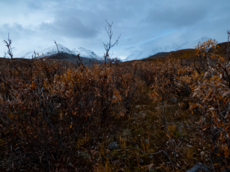
Eventually, we left the road and started through the willows and buffalo berry shrubs. Usually these areas are busy with grizzly scat but today we saw no scats from this year. Several moose scats along the way though.

We are approaching the suspension bridge over College Creek, which drains from College Glacier to the east..

Riley entering the bridge.

On the bridge. The first time we ever tried to hike to the glacier as a family, College Creek was too high for the dogs to cross, and they had no intention of walking across the bridge, so we turned around here.

College Creek running low.

The Hoodoo spires to the east.

In the Gulkana Glacier valley. The lateral moraine is ~400-feet high at the left but farther up valley is about 800-feet tall.

Finally some grizzly scat, full of buffalo berries. Also a few service berries??

Some buffalo berries. They are scattered in the glacial valley but in the lower valley where we parked (also a glacial valley) there are acres of the berries. Grizzlies love these berries but they taste like soap (their other common name is soap berry).

A USGS water gauging station on Phelan Creek. Ogive Mtn in the back right.

An early view of the glacier.

Sheep scat along the trail. I would have suspected this to be caribou scat base on the fact that the scat was in the valley bottom, but there were fresh sheep tracks nearby.

Riley taking a break.

One of the few cleared tent sites.

These tent sites are adjacent to clear streams that drain out of the lateral moraine to the east.

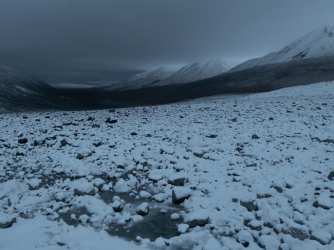
Looking down valley, a storm is brewing.

There were 7-8 people on or near the glacier as we approached. they all were headed back by the time we met up with them. One guy said he wished he had brought gear for an overnighter.

We are on the glacier now but the debris is covering the ice. The grey ice spilling off is the Gabriel Icefall. Ogive Mtn to the left, Skull Peak in the back.

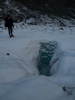
Riley checking one of the many moulins on the glacier.

Another view of the moulin.

The head of another moulin where ice melt has formed the canyon leading into the moulin.

Riley roaming the glacier looking for a flat spot to camp.

Another moulin near camp. Several years back a 12-year-old died on this glacier when he drove a snow machine into one of these.

A view of camp up glacier. The snowfield in the basin behind the tent is the remains of the Pegmatite Glacier.

Camp view down valley.

I fell asleep to the sound of freezing rain hitting the tent. Eventually it turned to snow.

Lucky for us, the snow was only a couple inches deep. Often enough these storms that move up from Prince William Sound dump feet of snow. Not sure how much more was expected, we packed up and left, snacking on the way down.

Riley, ready to go.

The more recent rubble-field of the retreating glacier. Riley led the way into a whole lot of muck.

We bailed out of the muck before soaking our feet and headed over to the drier route. Hard to tell but Riley is on a large ice shelf.

When I was here 3 years ago, the ice/snow shelf in the center was a 50-60 foot long ice tunnel.

Could not resist this picture. Riley put the smiley face in without me noticing until I downloaded the pics.

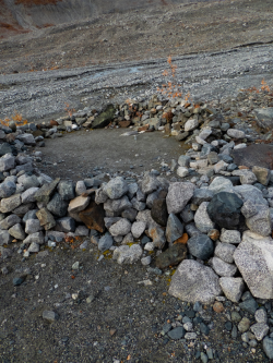
Headwaters of Phelan Creek with the cairn at the left.

View down valley.

The snow started falling again. I was glad we were heading out.

I missed the grizzly diggings on the way up, but here's sign of a grizzly digging out some Hedysarum alpinum corms. The fleshy roots are dense with carbs, grizzlies dig them out in the spring and fall.

Headed back to the bridge. Only rain down here.

Moose scat in the brush.

Last view of the Hoodoos.

Over and out.
Riley ready to go.
We continued up the road we drove in on.
Eventually, we left the road and started through the willows and buffalo berry shrubs. Usually these areas are busy with grizzly scat but today we saw no scats from this year. Several moose scats along the way though.
We are approaching the suspension bridge over College Creek, which drains from College Glacier to the east..
Riley entering the bridge.
On the bridge. The first time we ever tried to hike to the glacier as a family, College Creek was too high for the dogs to cross, and they had no intention of walking across the bridge, so we turned around here.
College Creek running low.
The Hoodoo spires to the east.
In the Gulkana Glacier valley. The lateral moraine is ~400-feet high at the left but farther up valley is about 800-feet tall.
Finally some grizzly scat, full of buffalo berries. Also a few service berries??
Some buffalo berries. They are scattered in the glacial valley but in the lower valley where we parked (also a glacial valley) there are acres of the berries. Grizzlies love these berries but they taste like soap (their other common name is soap berry).
A USGS water gauging station on Phelan Creek. Ogive Mtn in the back right.
An early view of the glacier.
Sheep scat along the trail. I would have suspected this to be caribou scat base on the fact that the scat was in the valley bottom, but there were fresh sheep tracks nearby.
Riley taking a break.
One of the few cleared tent sites.
These tent sites are adjacent to clear streams that drain out of the lateral moraine to the east.
Looking down valley, a storm is brewing.
There were 7-8 people on or near the glacier as we approached. they all were headed back by the time we met up with them. One guy said he wished he had brought gear for an overnighter.
We are on the glacier now but the debris is covering the ice. The grey ice spilling off is the Gabriel Icefall. Ogive Mtn to the left, Skull Peak in the back.
Riley checking one of the many moulins on the glacier.
Another view of the moulin.
The head of another moulin where ice melt has formed the canyon leading into the moulin.
Riley roaming the glacier looking for a flat spot to camp.
Another moulin near camp. Several years back a 12-year-old died on this glacier when he drove a snow machine into one of these.
A view of camp up glacier. The snowfield in the basin behind the tent is the remains of the Pegmatite Glacier.
Camp view down valley.
I fell asleep to the sound of freezing rain hitting the tent. Eventually it turned to snow.
Lucky for us, the snow was only a couple inches deep. Often enough these storms that move up from Prince William Sound dump feet of snow. Not sure how much more was expected, we packed up and left, snacking on the way down.
Riley, ready to go.
The more recent rubble-field of the retreating glacier. Riley led the way into a whole lot of muck.
We bailed out of the muck before soaking our feet and headed over to the drier route. Hard to tell but Riley is on a large ice shelf.
When I was here 3 years ago, the ice/snow shelf in the center was a 50-60 foot long ice tunnel.
Could not resist this picture. Riley put the smiley face in without me noticing until I downloaded the pics.
Headwaters of Phelan Creek with the cairn at the left.
View down valley.
The snow started falling again. I was glad we were heading out.
I missed the grizzly diggings on the way up, but here's sign of a grizzly digging out some Hedysarum alpinum corms. The fleshy roots are dense with carbs, grizzlies dig them out in the spring and fall.
Headed back to the bridge. Only rain down here.
Moose scat in the brush.
Last view of the Hoodoos.
Over and out.