Aldaron
Member
- Joined
- Jun 16, 2012
- Messages
- 1,487
Well, since my wife's ankle is still recovering from a nasty fall (Gravity!) in New Zealand back in February, we decided to head out for a drive in Wyoming this weekend to check out some new roads and trailheads. I'm still not entirely sure how we've missed these trails in the seven years we've been here, but I guess you can't go everywhere all the time.
So Friday after work we drove to Pinedale for the night. We called the Forest Service office in Dubois and they told us that the Union Pass Road still had a bad snow drift at Snowshoe Creek, and the road was impassable at that point. No biggie...we'd just check out trails in the Gros Ventre and Bridger Wildernesses on the Pinedale side of things.
Our first stop on Saturday was a potential trail at Tosi Creek leading into Gros Ventre. This isn't an official trailhead, but pictures I've seen of Tosi Creek Basin look outstanding, so I want to figure out a relatively painless way into this trailless area.
We found an interesting monument at the road intersection leading to the trailhead:

We found a trail that crossed a cold Tosi Creek early on, and because of the whole ankle thing, we decided to keep this one for another day. But it was nice to see that there is a chance of getting to the basin without starting from several miles north.
From there we headed up to the northern trailhead at Kinky Creek.


We hiked a little here. There was no one at the trailhead, so that was a major plus right from the start. We hiked above the valley until just inside the wilderness, then we headed back.
From there we continued up Union Pass Road, checking out a lot of side roads on the way. We found some great views, including views of the Tetons off in the distance, and lots of nice meadows, rivers, and lakes.


Tetons in the distance with antelope in the foreground:


After topping out at Union Pass, we started down to see how far we could get. We hardly saw a drop of snow until the road crossed a bridge. There was a deep snow drift on both sides of the road, but nothing on the road. I pulled out the GPS, and, sure enough, the bridge was crossing Snowshoe Creek. So regardless of what the Ranger station reported, the road appeared to be open. Cool. So we headed on down and made our way to Dubois...which, I learned, is not pronounced at all like my degree in French would lead me to believe. We stayed the night in Dubois, and the next day we drove up to check out trails heading into the Washakie Wilderness. We made the long drive out to the Double Cabin Trailhead, and thought the area was outstanding.

All of the trails from here crossed one or more major rivers right at the trailhead, so we decided to hold this for another day, too.
From there we drove up to the trail for Deacon Lake, and practiced using a very expired can of bear spray. Man, 30 feet isn't very far. Next we started home with a brief stop at Brooks Lake.


Honestly, we were blown away at how pretty this weekend was. We love to explore every interesting thing on a map, so I have no idea how we've missed this stuff before now. It is a bit of a drive for a regular weekend, but the Gros Ventre area outside of Pinedale is doable, and I'm looking forward to backpacking more out there.
So Friday after work we drove to Pinedale for the night. We called the Forest Service office in Dubois and they told us that the Union Pass Road still had a bad snow drift at Snowshoe Creek, and the road was impassable at that point. No biggie...we'd just check out trails in the Gros Ventre and Bridger Wildernesses on the Pinedale side of things.
Our first stop on Saturday was a potential trail at Tosi Creek leading into Gros Ventre. This isn't an official trailhead, but pictures I've seen of Tosi Creek Basin look outstanding, so I want to figure out a relatively painless way into this trailless area.
We found an interesting monument at the road intersection leading to the trailhead:
We found a trail that crossed a cold Tosi Creek early on, and because of the whole ankle thing, we decided to keep this one for another day. But it was nice to see that there is a chance of getting to the basin without starting from several miles north.
From there we headed up to the northern trailhead at Kinky Creek.
We hiked a little here. There was no one at the trailhead, so that was a major plus right from the start. We hiked above the valley until just inside the wilderness, then we headed back.
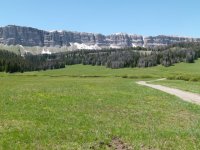
From there we continued up Union Pass Road, checking out a lot of side roads on the way. We found some great views, including views of the Tetons off in the distance, and lots of nice meadows, rivers, and lakes.
Tetons in the distance with antelope in the foreground:
After topping out at Union Pass, we started down to see how far we could get. We hardly saw a drop of snow until the road crossed a bridge. There was a deep snow drift on both sides of the road, but nothing on the road. I pulled out the GPS, and, sure enough, the bridge was crossing Snowshoe Creek. So regardless of what the Ranger station reported, the road appeared to be open. Cool. So we headed on down and made our way to Dubois...which, I learned, is not pronounced at all like my degree in French would lead me to believe. We stayed the night in Dubois, and the next day we drove up to check out trails heading into the Washakie Wilderness. We made the long drive out to the Double Cabin Trailhead, and thought the area was outstanding.
All of the trails from here crossed one or more major rivers right at the trailhead, so we decided to hold this for another day, too.
From there we drove up to the trail for Deacon Lake, and practiced using a very expired can of bear spray. Man, 30 feet isn't very far. Next we started home with a brief stop at Brooks Lake.
Honestly, we were blown away at how pretty this weekend was. We love to explore every interesting thing on a map, so I have no idea how we've missed this stuff before now. It is a bit of a drive for a regular weekend, but the Gros Ventre area outside of Pinedale is doable, and I'm looking forward to backpacking more out there.
")