- Joined
- Dec 23, 2013
- Messages
- 4,502
It was such a great day here in Salt Lake today. It was sunny with temperatures in the mid sixties, so my son and I decided to hike up Grandeur Peak via the Dragon's Tail Ridge Route.
The trailhead for this route is located at the end of Wasatch Blvd just south of Parley's Canyon. This is the same trailhead for the more popular West Slope Route which we will descend today. We start hiking around 9:30 am and soon are heading south on a jeep road.
 Grandeur Peak as seen near the trailhead
 Mount Olympus and Triangle Peak
 Hiking along the Jeep road
The first two ridges you come to have trails that head up the hill, but both of these are the West Slope Route, so we continue on to the next ridge to the south. The Jeep road eventually splits and we take the left hand road as it begins to climb. Between 200 to 300 feet up the road, there is a steep unmarked trail on the left. This trail is the one we want and it will lead us past a limestone rock formation know as the Dragon's Tail on our way to the top of the mountain.

Dragon's Tail Ridge Trail junction with Jeep road
Once on the trail, we soon came to a rock formation known as "The Reef" which is popular for beginning climbers. We worked our way around the east end of "The Reef" and up ahead you could see the western end of the Dragon's Tail.
 The Reef
 Approaching the Dragon's Tail
We hiked along the southern side of the Dragon's Tail where the trail becomes extremely steep. The formation is maybe 1/3 of a mile long and when we got to the top of it we stopped for a short break to eat an energy bar.
 Hiking along the Dragon's Tail
At this point the ridge becomes more rounded and the bushwhack through scrub oak begins. We were lucky and picked up a game trail that got us through a good portion of it.
 Making our way through the scrub oak
 About 2/3rds of the way up the mountain
Once out of the scrub oak, we found ourselves back on top of the ridge where we followed it to the summit.
 Working our way along the ridge

Still hiking along the ridge
 Looking up towards Grandeur summit from the ridge
 Looking back down the ridge we just hiked up
Once on top, We spread out our ponchos on the snow (6 or 7 inches on top) and ate our lunches. The views from the top were great in all directions.
 Mt. Aire
 Gobbler's Knob and Mount Raymond
While we ate our lunch, we had the top to ourselves. Eventually a few other showed up to enjoy the view. We packed our gear up and headed down the West Slope Trail back to the trailhead.
 Dragon's Tail Ridge as seen from the West Slope Trail
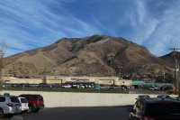
 Grandeur Peak from the REI parking lot. You can see the Dragon's Tail formation snaking up the mountain about halfway up. Yes, I was weak and bought a REI Flash22 day pack that was on sale for $28.00 .
It's a great hike and will definitely make you work up a sweat to get to the top. Total time including lunch was 4 hours and 50 minutes.
Featured image for home page:

The trailhead for this route is located at the end of Wasatch Blvd just south of Parley's Canyon. This is the same trailhead for the more popular West Slope Route which we will descend today. We start hiking around 9:30 am and soon are heading south on a jeep road.
Grandeur Peak as seen near the trailhead Mount Olympus and Triangle PeakHiking along the Jeep roadThe first two ridges you come to have trails that head up the hill, but both of these are the West Slope Route, so we continue on to the next ridge to the south. The Jeep road eventually splits and we take the left hand road as it begins to climb. Between 200 to 300 feet up the road, there is a steep unmarked trail on the left. This trail is the one we want and it will lead us past a limestone rock formation know as the Dragon's Tail on our way to the top of the mountain.
Dragon's Tail Ridge Trail junction with Jeep road
Once on the trail, we soon came to a rock formation known as "The Reef" which is popular for beginning climbers. We worked our way around the east end of "The Reef" and up ahead you could see the western end of the Dragon's Tail.
The ReefApproaching the Dragon's TailWe hiked along the southern side of the Dragon's Tail where the trail becomes extremely steep. The formation is maybe 1/3 of a mile long and when we got to the top of it we stopped for a short break to eat an energy bar.
Hiking along the Dragon's TailAt this point the ridge becomes more rounded and the bushwhack through scrub oak begins. We were lucky and picked up a game trail that got us through a good portion of it.
Making our way through the scrub oakAbout 2/3rds of the way up the mountainOnce out of the scrub oak, we found ourselves back on top of the ridge where we followed it to the summit.
Working our way along the ridgeStill hiking along the ridge
Looking up towards Grandeur summit from the ridgeLooking back down the ridge we just hiked upOnce on top, We spread out our ponchos on the snow (6 or 7 inches on top) and ate our lunches. The views from the top were great in all directions.
Mt. AireGobbler's Knob and Mount Raymond While we ate our lunch, we had the top to ourselves. Eventually a few other showed up to enjoy the view. We packed our gear up and headed down the West Slope Trail back to the trailhead.
Dragon's Tail Ridge as seen from the West Slope Trail Grandeur Peak from the REI parking lot. You can see the Dragon's Tail formation snaking up the mountain about halfway up. Yes, I was weak and bought a REI Flash22 day pack that was on sale for $28.00 .It's a great hike and will definitely make you work up a sweat to get to the top. Total time including lunch was 4 hours and 50 minutes.
Featured image for home page:


")
