IntrepidXJ
ADVENTR
- Joined
- Jan 17, 2012
- Messages
- 3,488
Wednesday – Saturday, April 13-16, 2016

The amazing petroglyphs of the Railroad Panel in Grand Gulch.
Spending a few days backpacking in southern Utah seems to have become an annual tradition for Dave, Jared and myself. A few months ago we started planning our trip to visit another section of Grand Gulch between Pollys Canyon and Collins Canyon that we had not been through before and Dave secured the backpacking permits for our small group. Our plan for Wednesday was to drive down and meet up at a campsite along the road to the Collins Canyon Trailhead. Dave and Jared would be leaving early in the afternoon from Salt Lake City and I’d be leaving after work from Grand Junction. I stopped for a quick dinner in Moab and made it to the campsite just after the sun set for the day. They had arrived about an hour before me. I quickly got my tentcot setup just after dark and we all went to bed early on this beautiful evening.
A nice drive across Cedar Mesa in my new Jeep just after sunset.
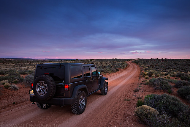
Collins Canyon Road with Navajo Mountain sticking up from the horizon in the distance.
On Thursday morning we woke up early, broke down camp, had a little breakfast and then dropped my Jeep off at the Collins Canyon Trailhead. Then I loaded my backpack into Dave’s Lexus and we drove around to the Kane Gulch Ranger Station and arrived just after they opened at 8:00am. We watched the short video, got our permit and then were on our way to the Government Trailhead. Instead of following the Government Trail into Grand Gulch (which we’d all done a few time before), we hiked east cross-country to the rim of Pollys Canyon and easily found an old constructed trail that took us to the bottom. We were happy to see that the canyon was very wet with pools and flowing water everywhere since that likely meant that water would be easy to find on this trip. However, all that water made route-finding through the canyon a little trickier in order to keep our feet dry.
After exploring Pollys Canyon we reached Grand Gulch in the early afternoon and setup camp on ledge just downstream from the confluence. Then we did a little more exploring up Grand Gulch until later in the evening before having a late dinner. After dark we got to bed early. It was a very calm and warm night and I never had to zip up my sleeping bag all the way. That would change for the rest of the trip, though.
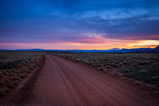
My Jeep shortly before sunrise from our camp along the Collins Canyon Road with the Red House Cliffs to the west.
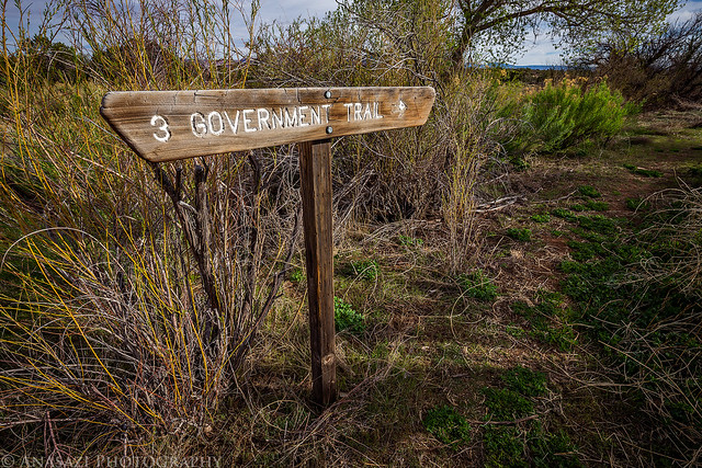
The start of the Government Trail that we would not be following this time.
The constructed trail we found down into Pollys Canyon.

A nice kiva we visited.

The first petroglyphs we came across on the trip.


Dave taking a photo of some pretty old petroglyphs that Jared spotted.

A breach in the wall with the door on the right.

We passed below Pollys Canyon Arch shortly before reaching Grand Gulch.

We finally made it to Grand Gulch.

It’s been about five years since the last time I was at the Big Man Panel, and it was nice to revisit.

This was a ruin and pictograph I really wanted to find on this trip and I was very happy when I spotted it from below. However, getting up to this one proved to be almost too difficult for me. If it weren’t for Dave’s help getting me up the first ledge, I know I wouldn’t have been able to reach it on my own.

Dave and Jared checking out the alcove.


Such a cool pictograph!


We visited these ruins hidden behind a large slab of sandstone shortly before sunset.

We would spend much of Friday thoroughly exploring the section of Grand Gulch between the Government Trail and Deer Canyon, where we would setup camp for the night. After seeing some blue early in the morning, the sky would become overcast for the rest of the day and trip. The wind picked up pretty good and would blow pretty hard for the rest of the trip, too. While it looked like it could rain for much of the day, we only had to hideout in an alcove to avoid the rain once just as we reached the confluence with Deer Canyon. When the short-lived rainstorm was over, we setup camp in Deer Canyon and spent the rest of the evening exploring the area.
Pollys Island early in the morning.

I revisited the Slab Ruins again without direct light shining on the ruins.


We spent some time exploring the Wrong Side Ruins, known as that because they are found on the opposite side of the canyon as the majority of the other ruins.

Fallen roof beams in another kiva.


View from the Wrong Side Ruins.

I was also hoping to find the Railroad Panel on this trip, and was happy to spot it during our hike today. The panel was much larger than I thought!
Here’s a close look at the newest petroglyphs in the panel.

Here are some of the older ones.

Here’s an panoramic image of the entire panel. You can click on it for a larger view.


This is nice well-preserved granary. Dave was the only one in our group able to climb over to it.


Polka-dot pictographs…


This is a pretty big red man pictograph located high above the canyon floor.


This ruin was located in the shallow alcove that we found refuge from the rain in.

I found a pretty nice campsite this evening. This was my first trip using my new Big Agnes Copper Spur UL2 tent.

It’s been a while since I’ve seen this many undisturbed potsherds laying on the ground. This photo is just of a small section.

It was another late dinner for us this evening. We went to bed right after it started to get dark out and just in time for one last rain shower that didn’t seem to last very long. However, the wind really picked up all night. It was very loud and didn’t let up the entire night. It certainly made sleeping a little difficult, but somehow my tent was in a dead spot and didn’t get hit by very many gusts. I could hear Dave’s tent flapping in the wind pretty good, though.
On Saturday morning we packed up camp and hiked up Deer Canyon a little ways before continuing on our journey down Grand Gulch. Again, it was overcast all day and still windy out.
Dave and his reflection in a pool in Deer Canyon.


Dave and Jared on a ledge above the wash.

It may not look small in this photo, but this is probably the tiniest granary I have ever seen.


There were plenty cactus blooming in the canyon, including this Hedgehog Cactus.

Eventually we reached Bannister House Ruin, which we had visited on our hike into lower Grand Gulch last year.

Hiking along a narrow ledge.


Two heads are better than one…

When we reached Collins Canyon we had a decision to make. Our original plan was to camp nearby for the night and then hike out in the morning, however the wind had been blowing hard all day and we were getting pretty tired of it. Since all campsites in this area were sandy (not fun with a lot of wind) and we had all explored this section of the canyon before, we decided to hike out the extra two miles today and head home a day early. Had the weather been a little nicer we probably would have spent that last night in the canyon, but as it was we had accomplished everything we wanted to on this trip and had a great time.
>> Pollys Canyon to Collins Canyon Photo Gallery
>> The Original Trip Report on ADVENTR.CO
The amazing petroglyphs of the Railroad Panel in Grand Gulch.
Spending a few days backpacking in southern Utah seems to have become an annual tradition for Dave, Jared and myself. A few months ago we started planning our trip to visit another section of Grand Gulch between Pollys Canyon and Collins Canyon that we had not been through before and Dave secured the backpacking permits for our small group. Our plan for Wednesday was to drive down and meet up at a campsite along the road to the Collins Canyon Trailhead. Dave and Jared would be leaving early in the afternoon from Salt Lake City and I’d be leaving after work from Grand Junction. I stopped for a quick dinner in Moab and made it to the campsite just after the sun set for the day. They had arrived about an hour before me. I quickly got my tentcot setup just after dark and we all went to bed early on this beautiful evening.
A nice drive across Cedar Mesa in my new Jeep just after sunset.
Collins Canyon Road with Navajo Mountain sticking up from the horizon in the distance.
On Thursday morning we woke up early, broke down camp, had a little breakfast and then dropped my Jeep off at the Collins Canyon Trailhead. Then I loaded my backpack into Dave’s Lexus and we drove around to the Kane Gulch Ranger Station and arrived just after they opened at 8:00am. We watched the short video, got our permit and then were on our way to the Government Trailhead. Instead of following the Government Trail into Grand Gulch (which we’d all done a few time before), we hiked east cross-country to the rim of Pollys Canyon and easily found an old constructed trail that took us to the bottom. We were happy to see that the canyon was very wet with pools and flowing water everywhere since that likely meant that water would be easy to find on this trip. However, all that water made route-finding through the canyon a little trickier in order to keep our feet dry.
After exploring Pollys Canyon we reached Grand Gulch in the early afternoon and setup camp on ledge just downstream from the confluence. Then we did a little more exploring up Grand Gulch until later in the evening before having a late dinner. After dark we got to bed early. It was a very calm and warm night and I never had to zip up my sleeping bag all the way. That would change for the rest of the trip, though.
My Jeep shortly before sunrise from our camp along the Collins Canyon Road with the Red House Cliffs to the west.
The start of the Government Trail that we would not be following this time.
The constructed trail we found down into Pollys Canyon.
A nice kiva we visited.
The first petroglyphs we came across on the trip.
Dave taking a photo of some pretty old petroglyphs that Jared spotted.
A breach in the wall with the door on the right.
We passed below Pollys Canyon Arch shortly before reaching Grand Gulch.
We finally made it to Grand Gulch.
It’s been about five years since the last time I was at the Big Man Panel, and it was nice to revisit.
This was a ruin and pictograph I really wanted to find on this trip and I was very happy when I spotted it from below. However, getting up to this one proved to be almost too difficult for me. If it weren’t for Dave’s help getting me up the first ledge, I know I wouldn’t have been able to reach it on my own.
Dave and Jared checking out the alcove.
Such a cool pictograph!
We visited these ruins hidden behind a large slab of sandstone shortly before sunset.
We would spend much of Friday thoroughly exploring the section of Grand Gulch between the Government Trail and Deer Canyon, where we would setup camp for the night. After seeing some blue early in the morning, the sky would become overcast for the rest of the day and trip. The wind picked up pretty good and would blow pretty hard for the rest of the trip, too. While it looked like it could rain for much of the day, we only had to hideout in an alcove to avoid the rain once just as we reached the confluence with Deer Canyon. When the short-lived rainstorm was over, we setup camp in Deer Canyon and spent the rest of the evening exploring the area.
Pollys Island early in the morning.
I revisited the Slab Ruins again without direct light shining on the ruins.
We spent some time exploring the Wrong Side Ruins, known as that because they are found on the opposite side of the canyon as the majority of the other ruins.
Fallen roof beams in another kiva.
View from the Wrong Side Ruins.
I was also hoping to find the Railroad Panel on this trip, and was happy to spot it during our hike today. The panel was much larger than I thought!
Here’s a close look at the newest petroglyphs in the panel.
Here are some of the older ones.
Here’s an panoramic image of the entire panel. You can click on it for a larger view.
This is nice well-preserved granary. Dave was the only one in our group able to climb over to it.
Polka-dot pictographs…
This is a pretty big red man pictograph located high above the canyon floor.
This ruin was located in the shallow alcove that we found refuge from the rain in.
I found a pretty nice campsite this evening. This was my first trip using my new Big Agnes Copper Spur UL2 tent.
It’s been a while since I’ve seen this many undisturbed potsherds laying on the ground. This photo is just of a small section.
It was another late dinner for us this evening. We went to bed right after it started to get dark out and just in time for one last rain shower that didn’t seem to last very long. However, the wind really picked up all night. It was very loud and didn’t let up the entire night. It certainly made sleeping a little difficult, but somehow my tent was in a dead spot and didn’t get hit by very many gusts. I could hear Dave’s tent flapping in the wind pretty good, though.
On Saturday morning we packed up camp and hiked up Deer Canyon a little ways before continuing on our journey down Grand Gulch. Again, it was overcast all day and still windy out.
Dave and his reflection in a pool in Deer Canyon.
Dave and Jared on a ledge above the wash.
It may not look small in this photo, but this is probably the tiniest granary I have ever seen.
There were plenty cactus blooming in the canyon, including this Hedgehog Cactus.
Eventually we reached Bannister House Ruin, which we had visited on our hike into lower Grand Gulch last year.
Hiking along a narrow ledge.
Two heads are better than one…
When we reached Collins Canyon we had a decision to make. Our original plan was to camp nearby for the night and then hike out in the morning, however the wind had been blowing hard all day and we were getting pretty tired of it. Since all campsites in this area were sandy (not fun with a lot of wind) and we had all explored this section of the canyon before, we decided to hike out the extra two miles today and head home a day early. Had the weather been a little nicer we probably would have spent that last night in the canyon, but as it was we had accomplished everything we wanted to on this trip and had a great time.
>> Pollys Canyon to Collins Canyon Photo Gallery
>> The Original Trip Report on ADVENTR.CO