Curt
Member
- Joined
- Feb 1, 2014
- Messages
- 426
On the first week of April 2016 we made this hike. This was my third hike below the Rim in the Grand Canyon - but it was the hike I wanted to do from the beginning. The other hikes were basically warm ups for this one and to test myself, my gear, and to get some experience below the Rim for myself and my hiking companions before attempting this. In preparing for this I read every trip report and watched every U-Tube video I could find for this route. I knew that this was going to be tough for me and it was a little depressing to read some reports where the authors clearly didn't consider it very challenging. But I'm over 60 now and have had a few significant health problems in the last few years. I knew it was getting down to now or never. So I dialed it in.
Five of us went; Steve, a classmate from high school. Scott, my brother-in-law. Jared, Scott's youngest son who is completing his senior year of high school. Brent, @b.stark of BCP. And me. We started at the Tanner Trail head and finished at Grandview Point. In planning the trip, it was agreed that I should keep the daily mileage low so I planned for 6 days with the longest day being under 8 miles. We camped the first night on top of the Red Wall near the Red Wall break just below Cardenas Butte. This was a dry camp but I chose it on purpose because of the awesome view there. The second night was spent at Cardenas Creek at the Colorado River. The third camp was at Escalante Creek at the Colorado River. The fourth was at Red Canyon at the Colorado River. The last night was spent at the creek crossing at Hance Canyon below Horseshoe Mesa. All of the camp sites except for the first were chosen to take advantage of reliable water sources.
I wasn't disappointed in thinking this would be hard for me. I was pretty shot at the end of 4 of the 6 days. I had been hoping that we would experience normal temperatures for this time of year especially at the River. Instead of the normal 70 degrees at the River we had about 90 degrees which made everything harder - at least for me. My GPS recorded 35 miles and an accumulated elevation change of 35000 feet (that's not a typo).
Having hiked about 100 miles below the Rim now, I think this hike is pretty representative of the best that the Grand Canyon has to offer. The "Escalante Route" section of the hike is considered by the Park Service to be off trail. However, its fully cairned and most of the way it looks like a developed trail. We never had to do any route finding. Let me know if you would like a copy of the GPS tracks.
Hope you enjoy the pictures.
Looking East from Lipan Point near the Tanner trailhead. The Tanner Trail makes it to the Colorado River near where the river disappear behind the cliffs in the upper right of the picture.

Looking West from Lipan Point. We made it back to the Rim a little left of where the smoke is on the horizon. 75 Mile Canyon is the canyon the picture is looking down toward the Colorado River Gorge.

This is the saddle between 75 Mile Canyon and Tanner Canyon - looking down 75 Mile Canyon. The smoke on the Rim is from a controlled burn that the Park Service was conducting.

This is the view east from our camp on the first night.

The cliff formation is called "Palisades of the Desert"

I got up at midnight to try to get a picture of the Milky Way. It turned out that it was still below the horizon at this time of night. The picture is taken looking back toward the South Rim. The bright star is Jupiter. The bright light on the Rim at the left is the light at Desert View Tower.

Morning view to the east.

The North Rim

View from the Tanner Trail

Finally at the River at Tanner Rapids. From left; Steve, Scott, @b.stark, Jared, and me.

While we were at Tanner Rapids we saw a helicopter landing nearby. The Park Service was replacing the containers at the toilets at Tanner Rapids. The crew took our picture with their helicopter.

On the Escalante Route somewhere between Tanner Rapids and Cardenas Creek. This area is called "Furnace Flats". A good name. It was somewhere between hot and damn hot.

We shared the beach at Cardenas Creek with river rafters who were from Canada. They said they were out for 14 days and were going about 200 miles. I really think I'd like to give this a try.

Morning at Cardenas Creek

@b.stark on the cliffs above Unkar Delta. Some rafters are below to the left coming to the Unkar Creek Rapids.


Looking down river from the cliffs at Unkar Delta.

The trail contours around just below the nearby jagged cliffs.

Looking back at Unkar Delta. There was an Ancestral Pueblo village in the delta. We couldn't see it, but it is visible on Google Earth if you look closely.

Descending down Escalante Creek to the River. @b.stark is visible on the knoll on the left.
Sunset at the rapids at Escalante Creek.

Looking down river from our Escalante Creek camp.

At the edge of 75 Mile Canyon. We were at the other end a couple days before. The trail contours around until you can drop down into the canyon. Then you make your way back to the river.

Looking down into 75 Mile Canyon. This picture doesn't do the scale of this justice. Its a long way down.

In 75 Mile Canyon.

Past 75 Mile Canyon on our way to the Papago Wall which is just visible where the river disappears behind the cliffs.
The Papago Wall is the cliff formation where Papago Creek intersects the River. The cliff extends out in to the river and cannot be bypassed on the river side. The way past this is up the cliff. Basically it involves climbing about 30 feet up a cliff.

This shows the 2 basic ways up the wall.

Steve and @b.stark going up the ledge route. Somehow, in person, this looked a lot more precarious than it does in this picture. After watching them do this I decided to take the cliff route.

Looking back toward the rapids where Papago Creek enters the River.

After climbing the Papago Wall, the next obstacle is descending the Papago Slide. Its as steep as it looks. Steve can be seen below trying to get around some boulders into the nearby chute.

The view upstream from our camp at Red Canyon. The Papago Slide is where the River disappears into the V at the center of the picture.

The river runs from right (east) to left (west). North is at the top. We camped in the trees at the bottom.

I tried again for the Milky Way. This is at 4:00 a.m.


First light at 5:00 a.m.

On the East Tonto Trail looking back at Hance Rapids where we camped at Red Canyon.

There are some historic asbestos mines operated by Peter Berry in the late 1800's on the north side of the River. Tailings piles spilling down the canyon walls identify the locations of the mines.


Mineral Canyon.

North Rim
Looking down into the intersection of Hance Canyon and the Colorado River Gorge.

Looking up Hance Canyon toward the South Rim. Horseshoe Mesa is on the right.

The weather changed on our last morning and we tried to get to the Rim before the rain caught us. This is looking down Hance Canyon toward the North Rim.

At "Last Chance Mine".

The Last Chance Mine was a copper mine and is at the top of the tailings. We camped in the trees a little ways above the pour-off at the bottom right of the picture.

The miners moved ore from the mine to the South Rim with mules. The trail they built is now called the Grandview Trail. Sections of the trail are paved with slabs of limestone and are still in good condition more than a hundred years later. Some trail construction can be seen on the upper left where the miners filled in a gully to get the trail across.

At the old Mess Hall on Horseshoe Mesa.

View down Cottonwood Canyon on the Grandview Trail. Horseshoe Mesa is the cliff formation with the knoll on top on the right side of the canyon.

Near the top of the Grandview Trail. Grapevine Canyon is on the left. Horseshoe Mesa is the U shaped formation on the lower right.

The view from Grandview Point.

It was a great hike with great guys. Thanks for reading my report.
Five of us went; Steve, a classmate from high school. Scott, my brother-in-law. Jared, Scott's youngest son who is completing his senior year of high school. Brent, @b.stark of BCP. And me. We started at the Tanner Trail head and finished at Grandview Point. In planning the trip, it was agreed that I should keep the daily mileage low so I planned for 6 days with the longest day being under 8 miles. We camped the first night on top of the Red Wall near the Red Wall break just below Cardenas Butte. This was a dry camp but I chose it on purpose because of the awesome view there. The second night was spent at Cardenas Creek at the Colorado River. The third camp was at Escalante Creek at the Colorado River. The fourth was at Red Canyon at the Colorado River. The last night was spent at the creek crossing at Hance Canyon below Horseshoe Mesa. All of the camp sites except for the first were chosen to take advantage of reliable water sources.
I wasn't disappointed in thinking this would be hard for me. I was pretty shot at the end of 4 of the 6 days. I had been hoping that we would experience normal temperatures for this time of year especially at the River. Instead of the normal 70 degrees at the River we had about 90 degrees which made everything harder - at least for me. My GPS recorded 35 miles and an accumulated elevation change of 35000 feet (that's not a typo).
Having hiked about 100 miles below the Rim now, I think this hike is pretty representative of the best that the Grand Canyon has to offer. The "Escalante Route" section of the hike is considered by the Park Service to be off trail. However, its fully cairned and most of the way it looks like a developed trail. We never had to do any route finding. Let me know if you would like a copy of the GPS tracks.
Hope you enjoy the pictures.
Looking East from Lipan Point near the Tanner trailhead. The Tanner Trail makes it to the Colorado River near where the river disappear behind the cliffs in the upper right of the picture.
Looking West from Lipan Point. We made it back to the Rim a little left of where the smoke is on the horizon. 75 Mile Canyon is the canyon the picture is looking down toward the Colorado River Gorge.
This is the saddle between 75 Mile Canyon and Tanner Canyon - looking down 75 Mile Canyon. The smoke on the Rim is from a controlled burn that the Park Service was conducting.
This is the view east from our camp on the first night.
The cliff formation is called "Palisades of the Desert"
I got up at midnight to try to get a picture of the Milky Way. It turned out that it was still below the horizon at this time of night. The picture is taken looking back toward the South Rim. The bright star is Jupiter. The bright light on the Rim at the left is the light at Desert View Tower.
Morning view to the east.
The North Rim
View from the Tanner Trail
Finally at the River at Tanner Rapids. From left; Steve, Scott, @b.stark, Jared, and me.
While we were at Tanner Rapids we saw a helicopter landing nearby. The Park Service was replacing the containers at the toilets at Tanner Rapids. The crew took our picture with their helicopter.
On the Escalante Route somewhere between Tanner Rapids and Cardenas Creek. This area is called "Furnace Flats". A good name. It was somewhere between hot and damn hot.
We shared the beach at Cardenas Creek with river rafters who were from Canada. They said they were out for 14 days and were going about 200 miles. I really think I'd like to give this a try.
Morning at Cardenas Creek
@b.stark on the cliffs above Unkar Delta. Some rafters are below to the left coming to the Unkar Creek Rapids.
Looking down river from the cliffs at Unkar Delta.
The trail contours around just below the nearby jagged cliffs.
Looking back at Unkar Delta. There was an Ancestral Pueblo village in the delta. We couldn't see it, but it is visible on Google Earth if you look closely.
Descending down Escalante Creek to the River. @b.stark is visible on the knoll on the left.
Sunset at the rapids at Escalante Creek.
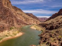
Looking down river from our Escalante Creek camp.
At the edge of 75 Mile Canyon. We were at the other end a couple days before. The trail contours around until you can drop down into the canyon. Then you make your way back to the river.
Looking down into 75 Mile Canyon. This picture doesn't do the scale of this justice. Its a long way down.
In 75 Mile Canyon.
Past 75 Mile Canyon on our way to the Papago Wall which is just visible where the river disappears behind the cliffs.
The Papago Wall is the cliff formation where Papago Creek intersects the River. The cliff extends out in to the river and cannot be bypassed on the river side. The way past this is up the cliff. Basically it involves climbing about 30 feet up a cliff.
This shows the 2 basic ways up the wall.
Steve and @b.stark going up the ledge route. Somehow, in person, this looked a lot more precarious than it does in this picture. After watching them do this I decided to take the cliff route.
Looking back toward the rapids where Papago Creek enters the River.
After climbing the Papago Wall, the next obstacle is descending the Papago Slide. Its as steep as it looks. Steve can be seen below trying to get around some boulders into the nearby chute.
The view upstream from our camp at Red Canyon. The Papago Slide is where the River disappears into the V at the center of the picture.
The river runs from right (east) to left (west). North is at the top. We camped in the trees at the bottom.
I tried again for the Milky Way. This is at 4:00 a.m.
First light at 5:00 a.m.
On the East Tonto Trail looking back at Hance Rapids where we camped at Red Canyon.
There are some historic asbestos mines operated by Peter Berry in the late 1800's on the north side of the River. Tailings piles spilling down the canyon walls identify the locations of the mines.
Mineral Canyon.
North Rim
Looking down into the intersection of Hance Canyon and the Colorado River Gorge.
Looking up Hance Canyon toward the South Rim. Horseshoe Mesa is on the right.
The weather changed on our last morning and we tried to get to the Rim before the rain caught us. This is looking down Hance Canyon toward the North Rim.
At "Last Chance Mine".
The Last Chance Mine was a copper mine and is at the top of the tailings. We camped in the trees a little ways above the pour-off at the bottom right of the picture.
The miners moved ore from the mine to the South Rim with mules. The trail they built is now called the Grandview Trail. Sections of the trail are paved with slabs of limestone and are still in good condition more than a hundred years later. Some trail construction can be seen on the upper left where the miners filled in a gully to get the trail across.
At the old Mess Hall on Horseshoe Mesa.
View down Cottonwood Canyon on the Grandview Trail. Horseshoe Mesa is the cliff formation with the knoll on top on the right side of the canyon.
Near the top of the Grandview Trail. Grapevine Canyon is on the left. Horseshoe Mesa is the U shaped formation on the lower right.
The view from Grandview Point.
It was a great hike with great guys. Thanks for reading my report.
Attachments
Last edited: