GPS Recommendation, Please

I did hear back from the Avenza folks. They made a suggestion of changing a setting in the GPS configuration. We will see if that helps!

I am curious about Gaia. If I download a map for offline usage, will I be able to check my location on that map while on the trail? Is it possible to leave waypoints on that map? The suggestions I read in an article about using your iPhone for a GPS suggested using Gaia and downloading maps. The article seemed to imply that you could save a lot of battery life by occasionally checking your location, instead of marking a trail continuously. That might work for me if I could drop waypoints onto that map. I usually do like to mark the entire route so I can then see miles traveled, and rate of speed (average moving speed and highest rate of speed). But, for purely not getting lost, or getting back to the truck, having a map and the ability to drop waypoints and then check my location on demand would work.
Yeah you can definitely do all that with Gaia.

Another app I might recommend is Backcountry Navigator Pro. It's cheaper than Gaia and a one-time cost, not a subscription service, and does everything you outlined above. Used it for years and very happy with it.
 
Yeah you can definitely do all that with Gaia.

Another app I might recommend is Backcountry Navigator Pro. It's cheaper than Gaia and a one-time cost, not a subscription service, and does everything you outlined above. Used it for years and very happy with it.

I also use backcountry navigator. Once the maps are downloaded and I am off in the woods, I put my phone on airplane mode and create a track. I can go all day and only use 30-40% of my battery. My settings are set to 20 seconds between each waypoint creation (probably a little overkill!).
 
I did hear back from the Avenza folks. They made a suggestion of changing a setting in the GPS configuration. We will see if that helps!

I am curious about Gaia. If I download a map for offline usage, will I be able to check my location on that map while on the trail? Is it possible to leave waypoints on that map? The suggestions I read in an article about using your iPhone for a GPS suggested using Gaia and downloading maps. The article seemed to imply that you could save a lot of battery life by occasionally checking your location, instead of marking a trail continuously. That might work for me if I could drop waypoints onto that map. I usually do like to mark the entire route so I can then see miles traveled, and rate of speed (average moving speed and highest rate of speed). But, for purely not getting lost, or getting back to the truck, having a map and the ability to drop waypoints and then check my location on demand would work.

John,
I routinely track every hike I do in GAIAGPS on and iPhone. That is continuous tracking leaving a line on the map as to where I traveled. Of course seeing your location on that map is probably the biggest reason for using the device. The little orange arrow shows where you are - no more triangulating or sleuthing it out. The track I make is for historical/archiving/publishing purposes as well as to be able to trivially easily track back in case of an issue. I do this for day hikes, for 3 day backpacks and for 10 day backpacks. I carry a supplemental battery to recharge the phone. You can leave the phone in airplane mode to save energy and the GPS receiver works just fine. I routinely carry all my required maps (of 3 different types) with me and all of my waypoints and old tracks. I also routinely save waypoints to the machine and do distance measuring on the device. I also have wilderness area boundaries custom loaded and use those boundaries for the conservation surveying I do. All of that data autosyncs to the GAIAGPS cloud when you get your device back online. You can even attach a picture at a waypoint and it will sync and be available at gaiagps.com and all the other machines connected to that datastore (I have three).It is a thing of beauty. It is not flawless but much, much more than good enough. I hearken back to my early days of trimmed paper 7.5 minute quads with a compass and laugh. I still carry said maps with me BTW, just in case, but can't remember the last time I needed them for navigating. Now I just use them in the field as an overview.

@Artemus , we really like Gaia too and I love that little orange arrow! What you describe is exactly what we did driving off road to coyote butte south and White Pocket, which had plenty of other roads going off to all other directions. Gaia works excellent for off road driving as well. We carry extra iPhone chargers/batteries. (We use a Garmin for hiking too, but I like Gaia better.) I’m also carrying a map, but I rarely use it anymore.
The only challenge with using Gaia on the iPhone in the winter, is that the iPhone battery really doesn’t like (that’s as diplomatic, as I can say it) cold or frigid weather. :rolleyes:
At Coyote Butte south I twice had to recharge my iPhone (mostly due to cold weather that day).
In the North East we have to keep the iPhone warm/toasty close to body (while hiking, running, etc) during the winter to keep it functioning.
 
We have found our inReach Explorer to work very well and reliably for tracking and navigating. We bluetooth it to our phones, though, so as to have a larger screen. A bonus with the Explorer is that you can send/receive text messages either from the inReach itself (a bit tedious with the buttons) or via your bluetoothed phone. There's also an SOS button (which we hope we'll never use!). The inReach's battery life is quite long, too, and the device seems very rugged.

Having said the above, though, we got turned on to Gaia several months ago and pretty much no longer use the inReach for tracking or navigating. We find the software to be easier to use than the inReach program and Gaia offers many more maps for both downloading and planning. The iPhone battery life isn't as good as the inReach so we make sure to keep the phone in airplane mode and turn off the screen before stowing the phone in our pocket. Like others we always carry power sticks/banks to recharge the phone if needed. However, in our opinion there are some downsides to Gaia...(a) Their satellite imagery is terrible. (b) Their maps aren't very good for driving. Perhaps we're just too accustomed to Google maps. (c) It can take a while to download maps for offline use, depending on the map size and level of detail.
 
I'm late to the conversation, but I've found my Garmin Oregon (purchased 2008-ish) touch screen to be lousy compared to an iPhone 7 even with iPhone in an Otterbox. Maybe newer ones are easier to work with but I'm frustrated with it so much I only use it when I have to. I'm going to carefully read this thread when I'm not a work to find a better solution.
 
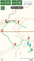
UPDATE: I am revisiting this thread in hopes of getting some help with the Gaia app! I have been using it lately and really like it! However, on a 5 hour trail ride yesterday I had a glitch. We were riding (horses) in an unfamiliar area and I added several waypoints to my tracked route. Each time I did so by choosing the second option, add waypoint using my current location. I do not understand the difference in choosing this option rather than the first option of simply adding a waypoint. Several times, to my shock, I found that there were gaps in my tracked route - immediately after I added a waypoint. Coincidence? Did I inadvertently stop the tracking? I know this is most likely user error and I am kicking myself. Any thoughts on what I might have done? I am attaching a screen shot of my route so you can see the gaps in routing. Previously, I tracked several routes successfully. But, I did not add many waypoints on those routes.
 

Attachments

  • 2E5BF3EA-F36E-43D7-84EA-474279CF96E4.png
    2E5BF3EA-F36E-43D7-84EA-474279CF96E4.png
    177.7 KB · Views: 32
UPDATE: I am revisiting this thread in hopes of getting some help with the Gaia app! I have been using it lately and really like it! However, on a 5 hour trail ride yesterday I had a glitch. We were riding (horses) in an unfamiliar area and I added several waypoints to my tracked route. Each time I did so by choosing the second option, add waypoint using my current location. I do not understand the difference in choosing this option rather than the first option of simply adding a waypoint. Several times, to my shock, I found that there were gaps in my tracked route - immediately after I added a waypoint. Coincidence? Did I inadvertently stop the tracking? I know this is most likely user error and I am kicking myself. Any thoughts on what I might have done? I am attaching a screen shot of my route so you can see the gaps in routing. Previously, I tracked several routes successfully. But, I did not add many waypoints on those routes.
strange, I've never experienced that and I take waypoints the same way as you explained. I'd reach out to Gaia; they've been really quick to reply and helpful when I've had questions.
 
strange, I've never experienced that and I take waypoints the same way as you explained. I'd reach out to Gaia; they've been really quick to reply and helpful when I've had questions.
Thanks, Brendan! I did just submit my inquiry to Gaia customer service. Many trail riders around me use the Avenza app. I have found it to have stability issues. Gaia seems to be very comprehensive. And, folks in this forum highly recommend it. We just spent six days riding trails and I used Gaia every day. I want to learn it! Pretty sure I did something wrong. Hope to find out.
 
Brendan, I know the Gaia app gets rave reviews here. I’ve tried it, with less luck than I like. Again, where we ride no app has been successful. Maybe there’s a way to augment my phone to improve on that. But, please consider the question I posed. I’m not looking to debate apps versus GPS devices. I’m asking for GPS device recommendations. Perhaps no one here uses them. That’s fine! If so, that is good information and I will inquire elsewhere.
Are you downloading the maps on Gaia before going out?
 
Another app that works really well and that I’m starting to like even better than Gaia is
Topo Maps + it’s pretty awesome!
 
Are you downloading the maps on Gaia before going out?

No. There are no maps available for my travel areas, at least none that I could find. Basically, I’ve been using Gaia to create a breadcrumb trail, with added waypoints, that I can save and then use in the future when I revisit these areas without a guide.


Sent from my iPad using Tapatalk
 
I do not understand the difference in choosing this option rather than the first option of simply adding a waypoint.

The difference is, current location is simply that, right where you are. The other option of create or add a waypoint lets you move that point around until you have it where you want it, away from your current location. Then if you select that waypoint it will give you a compass bearing and distance to that location. I’ve used it both ways, usually current location though.

Never had the glitch you are seeing and I’ve been using Gaia with an iPhone 7 Plus several times a week for over a year now. Your terrain does not look to be rugged enough to lose satellite lock like one can in a deep canyon but I can’t tell by the map if you were in heavy tree cover that might affect your reception.
 
There has to be. Are you in the United States? Try the CalTopo USGS quads layer.

We were in the Shawnee National Forest of southern Illinois. I am not aware of a way to d/l maps unless I am a Pro subscriber. At this point, I am evaluating Gaia to see if I should pay to subscribe.
 
The difference is, current location is simply that, right where you are. The other option of create or add a waypoint lets you move that point around until you have it where you want it, away from your current location. Then if you select that waypoint it will give you a compass bearing and distance to that location. I’ve used it both ways, usually current location though.

Never had the glitch you are seeing and I’ve been using Gaia with an iPhone 7 Plus several times a week for over a year now. Your terrain does not look to be rugged enough to lose satellite lock like one can in a deep canyon but I can’t tell by the map if you were in heavy tree cover that might affect your reception.

Well, we are usually in the Shawnee National Forest, so, yes, there’s tree cover most places. But, I used Gaia successfully four previous times until this latest attempt. The Gaia support person got back to me and suggested this sort of gap in continuity of tracking could occur if the app thought resources were maxed out on my phone, such as using a resource-heavy app simultaneously. Or by taking panoramic photos. I do take a lot of pictures and videos. I did take two pano pictures on this trip. But, the longest gap in tracking came before I did that. The area where Gaia has outpaced the other GPS apps I’ve tried is in accuracy of tracking. Other apps have a tendency to average my location, resulting in lots of straight lines in my displayed tracks. Gaia has never done that. And, I like the user interface with Gaia. I hope I can figure out how to avoid gaps in tracking. I also have yet to understand how to download maps in advance of my trip. I’m assuming that is a paid feature, but I have lots to learn about this app!
 
We were in the Shawnee National Forest of southern Illinois. I am not aware of a way to d/l maps unless I am a Pro subscriber. At this point, I am evaluating Gaia to see if I should pay to subscribe.

Isn't it worth $20 to try the fully functional software for a year? As your signature says, "Life is short. Ride your best horse." ;)
 
Isn't it worth $20 to try the fully functional software for a year? As your signature says, "Life is short. Ride your best horse." ;)

Yes! And I will likely do just that. So, if I do that I can download area tops maps prior to heading out and then track my progress on those maps?
 
Back
Top