Good trips in Southern Utah given current conditions

Wow, NWS/NOAA point forecast beginning this Friday at 5200ft near Cap Reef/Escalante:

Friday
A 20 percent chance of snow showers after noon. Partly sunny, with a high near 46. Breezy.
Friday Night
Partly cloudy, with a low around 21.
Saturday
A chance of snow showers after noon. Partly sunny, with a high near 39.
Saturday Night
A chance of snow showers, mainly before midnight. Mostly cloudy, with a low around 24.
Sunday
A slight chance of snow showers. Partly sunny, with a high near 40.
Sunday Night
Partly cloudy, with a low around 20.
Monday
Mostly sunny, with a high near 42.
Monday Night
Partly cloudy, with a low around 24.
Tuesday
Mostly sunny, with a high near 47.

Synopsis:
A moist Pacific storm system will bring significant
snow to the mountains and some mountain valleys of Utah through
Wednesday night. Unsettled weather will continue Thursday before a
rather unseasonably cold system moves through the area on Friday.
Yet another system will follow late Saturday into Sunday.
 
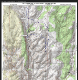
Exploring the "Deer Creek Ridges" area referenced on the map below provided by @John Morrow seems like it could make a decent short backpack, with paved access to a vast area of slickrock, lots of sun if the mornings are cold, and potholes likely full of water? The ridges and basins extend further south than shown. Check it out on Google Earth, there's some very colorful looking rock towards the south end!
Screen Shot 2023-03-21 at 3.51.24 PM.png
We did an exploratory morning hike there about 5 years ago, taking his easterly route more or less as shown above from the same starting point.
Crossing Deer Creek was a chore, as we wasted a lot of time wandering around looking for a spot that didn't involve a bunch of scratchy thrashing.
We only made it as far as point 6043, and returned via point 6002 after recrossing the creek. It's on the "re-do" list! Since then I came across this:
https://debravanwinegarden.blogspot.com/2020/05/deer-creek-east-slickrock-region-peak.html
which shows a different start as well as a "no crossing required" route. It looks like an awesome area to explore!
 
Last edited:
I know you were planned to go into GG today, but in case it helps you or anyone else.

@John Morrow and @SteveR are right that Deer Cr is right off the pavement. I couldn't recommend following John's western most approach right now...
From the TH you also have the approach to walk slightly away from the TH, due east, and then go up and drop back down on the other side of the creek, and you do not even have to leap Deer Creek or get wet.
As for conditions there, from Hwy 12 looking east, the snow was still thick and coating the area Friday afternoon when we drove through.
Deer Creek and into Grand Gulch from there would be a good from-pavement option. Lots of places to explore all the way to the Escalante.

Boulder Top def has not started melting out, but the amount of snow this year is almost infinite compared to pics I had from late March last year. If it warms up and Boulder starts melting, then the creeks and Escalante will rise.

HITRR had some big puddles and slick spots on Thursday afternoon March 23.
Farther down at either 40m or the canyon after that was all standing water on Thursday. But HITTR mostly tends to dry out quickly.

Last week we were off HITRR and we had snow, rain, high creeks, flooding, falls, mud in all places that are usually dry, terrible winds, and cold temps. Unsettled was the only word to describe it, and it seems like this week and next are following a slightly diminished and slightly warmer pattern.
 
re crossing Deer Creek, the "no crossing" route staying east of the creek is fun walking the slickrock lenses to get to the slickrock escarpment. It does have some steep ups & downs, however, so if you're backpacking or doing a long day hike, suggest you cross just below the Deer Creek "k" on the King Bench HTMC topo (the post-HTMC topos have much less info). The crossing is almost hoppable and is shallow. I believe Debra hopped across slightly further downstream near the "5" of "5640" by a draw on the east side.
 
Just got back from cold and snowy Zion. Backcountry areas in Upper East Canyon and Kolob Terrace still have lots of snow. Probably be a few couple of weeks before it all melts.
 
re crossing Deer Creek, the "no crossing" route staying east of the creek is fun walking the slickrock lenses to get to the slickrock escarpment. It does have some steep ups & downs, however, so if you're backpacking or doing a long day hike, suggest you cross just below the Deer Creek "k" on the King Bench HTMC topo (the post-HTMC topos have much less info). The crossing is almost hoppable and is shallow. I believe Debra hopped across slightly further downstream near the "5" of "5640" by a draw on the east side.

We have jumped it too during fall and fairly low water flow. But lately I’m wondering how “hoppable” Deer creek is once all the upstream snow starts melting:)
 
Back
Top