Good trips in Southern Utah given current conditions

Balsam

New Member
Joined
Mar 16, 2023
Messages
2
Hello! I am new here and am hoping you all can help me think about an upcoming trip. I have a permit for backpacking in Grand Gulch (Bullet to Kane) for March 27. Then heading to Boulder Mail Trail for a few days backpack. I'm concerned about backcountry conditions - and road conditions - given the wet year. Two questions:

1. What might conditions be like in both of these areas? I know Cedar Mesa is at around 6000ft. Is it advisable to stick with the trips as scheduled? Is it likely to be miserably cold and wet or muddy? Should we look for something lower?

2. Can you advise other trips that might be nice alternatives with better weather outlook or lower elevation? We're driving in from WA so can point ourselves wherever we wish!

I am a fit, experienced 60 yo backpacker. Very comfortable with navigating off trail. I'm leading a group of 3 women friends who are all in good shape but somewhat less experienced. We can certainly manage some scrambling but are not in the market for anything technical.

We're looking for two separate 3 night backpack routes. Plus areas to explore on dayhikes. We'll be camping in the area for 2 weeks.

Thanks for any thoughts you can share!
 

utahastro

Member
Joined
Dec 30, 2021
Messages
23
Regarding road conditions, the BLM publishes a report (link) for a number of the more popular dirt roads in and around GSENM. I suggest calling the GSENM visitors center and the Kane Gulch ranger station to get the most up-to-date road conditions for your specific itinerary. In addition to the road conditions, they could probably tell you whether there's snow/ice along your intended hiking route. Based on conditions near St. George at elevations similar to the areas you mentioned, I'd expect there to be snow (at the very least in the shade and on north-facing slopes).

More generally, this entire winter has been relentlessly cold (frequently 10-15F below normal) and wet by southern Utah's standards; even now, the 10-day forecast would be more typical of mid-January than late March. So a lot of the hikes that would normally be pleasant in mid-March might not be this year.
 

Balsam

New Member
Joined
Mar 16, 2023
Messages
2
Thank you Utahastro. That's the sense I've been getting as well. Do you have any thoughts about Lower Dark Cyn? At about 4,000 ft, I wonder if the elevation low enough there to hope for better conditions.

Also, I know very little about the Needles but it also appears to be a bit lower in elevation. Though it is a bit further north. Would that be a better bet than GG or BMT?

Is there good backpacking around Hite Marina area? Northern AZ?

Questions, questions! I greatly appreciate any input.
 

CodyL

Member
Joined
Jan 23, 2018
Messages
75
The Needles area is a great alternative when dealing with muddy, sloppy dirt roads in other places. You may have to adjust your trip plan to do more of the day hike/pavement type trip. The road is paved all the way to the trailhead if you're going to loop A or B to hike the common trails into Chesler Park. Problem this time of year is that most backcountry sites are probable full in the needles. You may get lucky and have someone cancel and open up a spot.

Lots to see along I-70 and down in the Moab area if you haven't been there before. Besides the Needles, other paved roads that lead to good hiking are Island in the Sky and Arches. Both have some nice day hikes, especially for first timers to the area.

https://www.nps.gov/cany/planyourvisit/road-conditions.htm

The 7 day forecast is calling for more rain next week as well.
 
Last edited:

TrailScot

Member
Joined
Dec 2, 2019
Messages
94
Hi @Balsam,

That sounded like a great itinerary you had planned, but I think you're right to be concerned about the current conditions.

However, given the incredible knowledge and helpfulness of the folks on this forum, you'll soon be overwhelmed with fantastic alternative solutions :)

Regarding the Bullet/Kane route; last year I dropped into Grand Gulch in March from Dripping Canyon, when the snow level on the mesa was around 6,000 ft. There was a very little snow in Dripping, but in GG at 5,200 ft there was a fair amount underfoot, since it is very sheltered there. For your Bullet/Kane hike, given it's almost 20 miles long, I'd be a little nervous about what you may encounter; it would be no fun to have to turn back. On the plus side, both trailheads are very close to the highway, so you should be able to reach these without too many problems.

As an alternative, you could consider starting a hike from Collins Trailhead, and dropping into Grand Gulch from there. The trailhead is much lower at 5,100 ft (Bullet and Kane at 6,400 ft). You could base yourself at the junction of Collins/Grand Gulch or further into GG, and then do some long day-hikes from there, both north and south. There are some wonderful archaeological sites to visit in this area, and the scenery is superb.

Whatever your plans, it'd be worth contacting the excellent folks at the Kane Gulch Ranger Station, to ask their advice.

For the Boulder Mail Trail, a close-by alternative could be to head down the Hole-in-the-Rock road from Escalante and explore some of the amazing canyons in this area (I see from the latest road report that this road is currently dry and open; see link below). I highly recommend a multi-day backpack into Coyote Gulch; it is one of the most beautiful places I've ever seen, with glorious scenery and abundant water. It's easy to access from the Hurricane Wash trailhead.

I'd completely agree with @CodyL about considering Needles as another alternative, especially given the current conditions. I just checked the availability of overnight backcountry campsites on recreation.gov and although much of the main section of the park is unavailable, as usual, there is plenty of availability for other sections such as Salt/Horse and Needles North. You could have a fantastic 3 night backpack in the park using either of these areas to camp.

For your idea about Dark Canyon, the main issue here may be accessing a trailhead, since Woodenshoe, Peavine etc are over 8,000 ft. The Sundance trailhead at 5,500 ft may be accessible but I'm not sure what the road condition would be like. The other problem may be the hiking conditions in Dark Canyon itself. I hiked through here in May 2019, which was the last big snow year, and it was not an enjoyable experience at all. The main canyon gathers snow-melt from the high surrounding mesas, and normally dry sections of DC had fierce, thigh-high water thundering through. It would probably be fine to do some day-hikes from below Sundance, but I'm not sure it'd be worth the trip down there.

 
Last edited:

John Morrow

Member
Joined
May 22, 2015
Messages
979
Unfortunately, the GCNRA Road Conditions are still showing 10 days to 2 weeks old. There probably was some downpours across the region since but don't know if the snow level came below 6000ft. Island in the Sky cam shows dry/no snow. High country on Zion Cam showing snow lingering and substantive. Hoping to be in the region in 10 days or less so, I too, am interested in hearing any direct observations folks may have. I would think the Needles zones are snow free. The good news is there ought to be lots of water supply for the next three weeks.
 

Janice

Member
.
Joined
Dec 5, 2017
Messages
842
Unfortunately, the GCNRA Road Conditions are still showing 10 days to 2 weeks old. There probably was some downpours across the region since but don't know if the snow level came below 6000ft. Island in the Sky cam shows dry/no snow. High country on Zion Cam showing snow lingering and substantive. Hoping to be in the region in 10 days or less so, I too, am interested in hearing any direct observations folks may have. I would think the Needles zones are snow free. The good news is there ought to be lots of water supply for the next three weeks.
Thanks for mentioning the Island in the Sky webcam - I hadn't known about that. We're heading to that area in a few weeks and I'm also checking on conditions...
 

fossana

Member
Joined
Jan 11, 2018
Messages
696
Unfortunately, the GCNRA Road Conditions are still showing 10 days to 2 weeks old. There probably was some downpours across the region since but don't know if the snow level came below 6000ft.

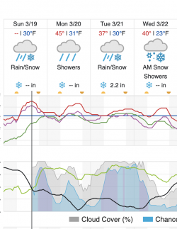
I've been watching the forecast closely. Things have warmed up in the SW, Escalante area to a lesser extent. Last I checked the river gauge it was still too cold for major snow melt. The SW has been getting hammered with precipitation, and I know Paria-Vermillion Cliffs flash flooded on Monday. It looks like there's a good chance of that happening in the Escalante Canyons on Tue.

Screen Shot 2023-03-19 at 3.35.51 PM.png
 

Stickerbumper

Member
Joined
May 16, 2017
Messages
43
Thanks for mentioning the Island in the Sky webcam - I hadn't known about that. We're heading to that area in a few weeks and I'm also checking on conditions...

Easiest way to figure out most up to date snow coverage (or when it has snowed last, how long it has been dry ect.) is via Caltopo. You need a pro account (I know it's 50$ annually, but IMO worth it) and then simply stack the Sentinel Weekly map on top of your mapped route. You can also choose the date you want to see the sat imagery for.

However, if you just want a general overview of how much snow you can expect, just plug the location you are interested in into the Sentinel Hub Playground and you are good to go


Janice

Member
.
Joined
Dec 5, 2017
Messages
842
Easiest way to figure out most up to date snow coverage (or when it has snowed last, how long it has been dry ect.) is via Caltopo. You need a pro account (I know it's 50$ annually, but IMO worth it) and then simply stack the Sentinel Weekly map on top of your mapped route. You can also choose the date you want to see the sat imagery for.

However, if you just want a general overview of how much snow you can expect, just plug the location you are interested in into the Sentinel Hub Playground and you are good to go

I'm remembering that I had gotten Caltopo pro a few years ago when I was checking on snow conditions, but then I discontinued it because I hadn't used it in awhile. Time to get it again! I just checked out Sentinel Hub Playground and found that helpful. Thanks for suggesting it. :)
 

regehr

Member
Joined
Mar 28, 2012
Messages
1,952
I just got back from four days in the broader Trachyte Canyon system. we picked that area because it seemed fairly tame and also is low elevation and can be accessed from pavement.

starting on Thurs March 16 we had planned to walk down lower Maidenwater, but Hanksville had gotten like a half inch of rain the day/night before, and deep wading in frigid water with backpacks didn't sound too fun, so we walked down Trail Canyon, which is easy and fairly scenic. it was running nearly top to bottom. Trachyte was very cloudy and running enough that it couldn't be crossed without getting wet feet. we camped up near the mouth of Maidenwater and then the next day walked up Maidenwater without packs for maybe a mile or a bit more until we got stopped by a cold pool. there was some pretty sketchy ice in places. after getting back to our packs we walked down to where Woodruff comes in, and camped up on a bench near there. the water coming out of Woodruff was almost as cloudy and nasty as the water in Trachyte, ugh! but it settled out pretty well overnight. next morning we hoped to go up Woodruff but we got stopped quite quickly by a deep pool and again it was cold enough that this didn't seem too fun. we were basically in there to have fun and explore and relax in the sun with coffee and whisky, rather than seeking canyon adventure. so anyway we just walked back up to Maidenwater and dropped our packs and day hiked some of Road Trip Ryan's class 4 surface-level return route, which goes through a lovely navajo dome zone. then we camped again, and woke up this morning and walked back out Trail Canyon.

we had good weather and sunny skies. water bottles that we left sitting out were mostly frozen solid in the mornings -- I'm not sure what temperature that indicates but I'm guessing lows in the mid/lower 20s. days were breezy and pleasant but not exactly warm. we didn't see anyone in there at all. we didn't see any cows either, but there's an awful lot of cow shit so I guess we just got lucky on that score. it's a nice area.
 
Last edited:
Similar threads
Thread starter Title Forum Replies Date
M 7 days in Southern Utah - Multi day backpacking trips? Trip Planning 6
Rockskipper Application Period Open For 2023 Private River Trips Through Grand Canyon National Park General Discussion 0
ghsmith76 Looking for best multi-day Backpacking Trips near Livingston, MT Trip Planning 6
Jimmy River Trips in April - Family of 5 Trip Planning 3
wsp_scott A couple trips with kids Backpacking 1
regehr triangular float trips On The Water 8
SKLund Plagarizing Trips General Discussion 13
CodyL Bechler Canyon side trips Trip Planning 3
Jimmy Ozark National Scenic Riverways Multi-Day Trips General Discussion 0
Absarokanaut Captions for Rotating Photos of Trips on Forum "Home" Page? Questions, Suggestions & Support 6
swmalone Question about Moab Canyoneering Trips/Guides General Discussion 8
WasatchWill Two trips in one at Capitol Reef Backpacking 12
SKLund How Big a Pack for Long Trips Gear 32
Perry Late Season Uintas Trips - What Do I Need to Know? General Discussion 15
Bryan Harwood Absaroka- Beartooth Wilderness: 6 Trips July-Sep. 2015 Backpacking 12
Howells Outdoors Oregon Backpacking Trips Trip Planning 10
Nick Invite River Trips: Take me! Meet Up (Members Only) 8
Nick Guided River Trips General Discussion 37
Kullaberg63 Lockhart Basin bikepacking, with side trips. Hiking & Camping 8
steve 2015 packrafting trips Meet Up (Members Only) 41
L Western Washington noobie trips in winter? Trip Planning 4
andyjaggy June Mountain Trips Trip Planning 1
Aldaron Boredom on winter trips General Discussion 11
fiber Invite Muddy Creek 6 day loop or other trips in May? Meet Up (Members Only) 6
Nick Favorite Trips of 2012 General Discussion 9
Deadeye008 Video TR from some recent trips On The Water 2
DAA How much food do you take on backpacking trips? General Discussion 12
Nick Food management on long distance trips General Discussion 4
Nick Short backpacking trips in the Escalante/Boulder area Trip Planning 20
Nick Weekend Backpacking Trips Trip Planning 19
kwc Short Snowshoe Hike today, Southern Adirondacks Hiking & Camping 2
J A few weeks in Southern NV, AZ and CA deserts Nov 2022. Hiking & Camping 11
fossana New National Monument planned in Southern NV General Discussion 3
Shawn Gossman Howdy from Southern Illinois! Noobs: Introduce yourself! 1
rhubarrbb White Pocket - Lone Tree Road / Southern Road Trip Planning 3
kwc Another Southern Adirondacks hike - Clockmill Pond and Rock Lake Hiking & Camping 0
V four day backpacking trip in southern Utah starting this weekend Trip Planning 4
D jackets found in southern Utah Noobs: Introduce yourself! 0
kwc Southern Utah Accommodations Question General Discussion 10
Outdoor_Fool Week-long Ramble Through Southern Yellowstone Backpacking 22
CodyL Southern Utah in January Backpacking 11
T Southern Utah Backpacking ideas for MLK Weekend? Trip Planning 21
kwc Hadley Mountain Fire Tower hike, Southern Adirondacks Hiking & Camping 1
kwc Good Luck Cliffs, Southern Adirondacks Hiking & Camping 0
TheMountainRabbit Southern Absaroka Loop (Teton/Washakie Wilderness) - August 2021 Backpacking 8
kwc Sunday Paddling in the Southern Adirondacks On The Water 2
kwc Short jaunt to Broomstick Lake, southern Adirondacks Hiking & Camping 2
Mountain Wanderer Four Lakes Basin in the Southern Cabinet Mountains - Montana Backpacking 12
long4trails Hello from Southern California Noobs: Introduce yourself! 3
kwc How things can change in a month … canoeing in the southern Adirondacks On The Water 2

Similar threads

Don't like ads? Become a BCP Supporting Member and kiss them all goodbye. Click here for more info.

Top