Good Nav programs for Android phone

Glasterpiece

Member
.
Joined
Mar 19, 2014
Messages
560
I searched but found nothing.

I just got my first smartphone and would like to know if others use their phones for map programs. If so, what are some of the better ones?

I would like to have something with satellite view.

I don't mind paying to download the areas that I want.

Any suggestions?
 
I am a GAIA GPS advocate (and beta tester) but mostly on an iPhone. I have friends that highly use and recommend it on Android. Try it out. It is a subscription service but really worth it. Really.

It supports downloaded maps and sat view and even the Topos Illustrated Maps with the premium subscription.
https://www.gaiagps.com/

BTW there are whole threads here on phone GPS use in backcountry here.
 
I've been very happy with Backcountry Navigator for the last couple of years. A friend has Gaia and is happy with that. I don't think you can go wrong with either one. Don't know about satellite view though.
 
I would like to have something with satellite view.

I don't mind paying to download the areas that I want.

Any suggestions?
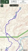
The Member level Gaia $20/year subscription does a satellite view on my iPhone 7 Plus. It has a very clean Gaia topo too as well as USGS topo, all for download. You can plan and/or save routes and all the stats Including altitude profiles, any waypoints too of course. It is a full feature gps. I’ve been using gps since 1993 and find Gaia with this phone’s gps chip to be very accurate.
 
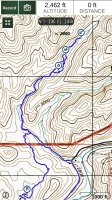
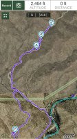
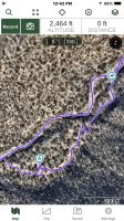
Here are some screenshots that may help, all of these downloaded for use offline and on airplane mode in the wilderness. I recorded a route over them with some waypoints and ca see the places we hiked off trail and even some 30’ digreeions off the route. All views can be zoomed in and out for clearer detail or a wider more sweeping view.

First the clean Gaia topo.


16801955-75E7-41D4-9EB5-391D8AD6358C.jpeg

And below the USGS topo view. There are also a couple other views with some shading.

1E90F828-D097-4184-A61C-B7769B921C72.jpeg

Below is the satellite view of the same area. As I zoomed in it did get sharper.

508EA723-8870-48B4-9F75-659E57E704E5.jpeg


When in the app you can zoom in to about the detail below. You can’t do the same with a screenshot though. This screen is set to show all the menus. Some visible features can ce changed,


06777B24-F755-465D-AF18-3FB1660210B8.jpeg
 
How does it work in airplane mode?
It doesn't actually pull down any data in airplane mode for layers (topos). The GPS works fine in airplane mode and disabling all the other radios (cell, wifi, bluetooth) of airplane mode saves quite a bit of battery life. The standard workflow is that you download the maps that you need to the device in GAIA beforehand including many different layers and these work great off the networks such as when you are in the backcountry in airplane mode.
 
Thank you for all the responses and advice. I'll give Gaia a try first.
 
I use OsmAnd on Android and am pretty happy with it. I've basically stopped taking paper maps on trips, even multi-day and off-trail, except maybe a big map giving an overview of an area, which is hard to get from a phone screen. I'd rather take a backup phone than futz with all the paper.
 
Another Gaia GPS user here. It does everything I need and seems worth the price for me.
 
I like to plan, measure, and draw out my routes with CalTopo. I then create a custom PDF of it and link to it on my phone with the Avenza Maps app for offline use. It has helped me stay on track numerous times. I also save the PDF to my Google Drive for fast access for future use. Longer routes, like the Uinta Highline trail, require multiple page PDFs to preserve topo detail, and since the free version of Avenza only allows 3 custom imports at a time (it only supports one page PDFs), I download all the PDFs to my phone before the trip, and then just change them out on Avenza when out on the trail as progress is made. I have played around with Gaia a bit, and it is pretty good, but I'm so familiar with the interface of CalTopo now, that I've just become more comfortable creating my maps there.
 
You can export tracks from caltopo and import them to Gaia, or even Google earth. you can also create tracks on Google earth and put them in Gaia, though since I've started using caltopo I rarely create tracks on Google earth. caltopo seems a bit more handy.
 
I like to plan, measure, and draw out my routes with CalTopo. I then create a custom PDF of it and link to it on my phone with the Avenza Maps app for offline use. It has helped me stay on track numerous times. I also save the PDF to my Google Drive for fast access for future use. Longer routes, like the Uinta Highline trail, require multiple page PDFs to preserve topo detail, and since the free version of Avenza only allows 3 custom imports at a time (it only supports one page PDFs), I download all the PDFs to my phone before the trip, and then just change them out on Avenza when out on the trail as progress is made. I have played around with Gaia a bit, and it is pretty good, but I'm so familiar with the interface of CalTopo now, that I've just become more comfortable creating my maps there.
Agreed with b.stark, create routes/plan trip on caltopo and export gpx for use in Gaia.

I used BCN on Android for a while (Gaia had some bugs at the time) and it worked fine but have been using Gaia (for iOS) for a couple years now and it’s damn near perfect as far as I’m concerned. Well worth the subscription.
 
Yeah, Exporting your tracks from Caltopo to Gaia is waaaaay easier (and unlimited) than what you are doing with Avenza. Give it a shot.
 
Yeah, Exporting your tracks from Caltopo to Gaia is waaaaay easier (and unlimited) than what you are doing with Avenza. Give it a shot.

I will give that a go on my next trip along side Avenza. I guess I just like the variety of icons with CalTopo that can be placed as way points and all that and it's all preserved in the PDF. Where I imagine those icons are all converted to a generic icon in a GPX track imported to Gaia. Still, I can see where the Gaia app becomes more advantageous with bigger, longer routes.
 
Similar threads

Similar threads

Back
Top