RyanP
Member
- Joined
- Mar 1, 2015
- Messages
- 702
Nine years ago, soon after moving out here, I went on my first CO backpacking trip. Over the last four days, I had the pleasure of returning to that area with my 15-year-old son Caleb and doing a longer variation of that loop:
Day 1
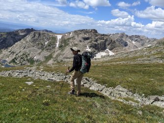
We got nice views right from the trailhead:

Despite it being a Wednesday, we saw a number of hikers in the first few miles. It makes sense, since it is still summer break and the hike to the first lake is (in my opinion) one of the nicest short/easy hikes within 1.5 hrs or so from Denver. Last time we came here as a family, we saw a large bull moose right off the trail. We had no such luck this time, but the views were spectacular nonetheless:

We sat and filtered water a little above the lake, at a glorious break spot:
Once atop the first pass (a few miles later), Caleb convinced me to hike a little higher to the top of one of the peaks right off the pass. Just a year or two ago, it was me talking him into doing additional side trips. Now, I'm just trying to keep up. The little side trip was well worth it and the panoramic views from the top were better than I expected:


The West side of the pass is the most challenging part of the standard loop, and I had read that a rock slide had made it more difficult. It looked daunting from above:
The rocky section wasn't nearly as hard as we feared, and it didn't take us too long to get down to the grass. The views were spectacular in this section, with tons of rock towers (like the one center-right in the photo above) on the West slopes of the peaks.
The hiking was sublime once we made it down to the grass:

Looking back up, it sure looked impossible (impassable?). How did we get down that? Where IS the pass?

The West side of the wilderness area (at least once you get far enough in) is so much nicer than the East side. We took our time strolling down to the next lake, enjoying the wildflowers and exploring around the lake a little:


What an underappreciated lake! It's understandably overshadowed by the more famous lakes that are just around the corner, but this was a spectacular destination in its own right.


We hiked a little further and got our first views into the famous cirque:

Note the little sharp point at the front of the ridge left of center in the above photo. It's funny how the perspective plays tricks on you when you're standing below it (see photos below, where it looks like that's by far the highest peak around).
A handful of years ago, I hiked in here and climbed the peak on the right side of the above photo, and I remember it being one of my favorite peaks. Seeing it here made me really want to get up early on Day 2 and climb it again. But we weren't in good enough shape to tack that on, so it would have to wait for a different time.
It didn't take us long from there to get to the spectacular cirque. We were both pretty tired at this point.


It's hard to believe that this was the low point on the ridge in the photo earlier.
Instagram (and recreation.gov to some degree) has kind of ruined this place, making it very hard to get backpacking permits here. When I first camped here nine years ago, we booked the permits three weeks in advance. They now all get booked within minutes (or seconds?) of opening for reservation. Despite that, almost all of the campsites were empty on this beautiful summer evening. We wandered around and checked out almost all of the twelve sites, and only two had tents in them. They need to change the system to give more incentive to cancel if you can't make it. In any case, I was selfishly grateful that we had great solitude on this beautiful evening.

After eating dinner by the lake, I was carrying the random dinner stuff back up to camp (not far from the lake), and saw a pair of eyes reflecting off my headlamp in the dark. I then saw that it was a little pine marten or weasel. It quickly scurried off. I was excited to mention this to Caleb. Then seconds later, in the other direction, I saw two other lights (reflection off of eyes--they really look like bright little LED flashlights). These were much further off the ground and much further apart. It took me a second for my eyes to make out the outline of the moose walking toward me in the dark. I moved to a safe spot and called Caleb over to check it out. It was eerie watching the large creature so near our camp. I was pretty spooked by that and was jumping at every sound for a little while. We both ended up sleeping great that night (and every night on this trip) though.
Day 2:
We slept in and slowly left camp, enjoying the views of the various peaks.


We then passed a series of nice cascades/waterfalls on the popular trail:


After a handful of miles on easy-going trail, we left the standard loop and headed up a side trail to another high lake. The scenery in this section was better than I expected, with the peaks slowly coming in to view as we got higher.


After a million switchbacks, we made it to the beautiful lake. We would climb up much closer to the peak left of center in the photo below (looming above the lake) the next morning.

There was a nice campsite with the above view, but when I find a nice campsite, I always like to spend time exploring around to find an ever better site. It usually proves successful and worthwhile. We had fun making our way around the lake:

...and ended up at a spectacular campsite on the North side of the lake. Even though it wasn't at all hot, I had to jump in that lake--it was a clean, deep lake, and I had two days of grime built up. It was freezing but still wonderful.

Having this area all to ourselves was easily one of the highlights of the trip. What a special place. It felt like the lake was on top of the world, with the high peaks just barely peaking up over the trees.

Day 3:
This was going to be the tough day, but also the day that we were most excited for. Almost the entire day would be off-trail, and it would involve a fair amount of elevation gain/loss with the heavy packs. We woke up before 6 and starting hiking just after 7, but we really should have woken up and started earlier than this to avoid the risk of afternoon thunderstorms. As it is, we got lucky with the weather and didn't have any problems.

We headed North and wandered through some gorgeous, easy, terrain.


We slowly made our way around the lake, and headed up to the North saddle of the major peak. There was some annoying talus and a somewhat-steep slope to contend with, but nothing too sketchy. This section was slow-going and the terrain wasn't fun, but the scenery was spectacular and we had it all to ourselves.

The panoramic view from just above the saddle was one of my favorites from the trip:


We finally got up to the easy tundra on top of the divide. We took a short break and meandered North to a relatively rarely-visited Peak.

The view into the canyon to the West was grand; over the course of the day, we discussed possible future trips through there.

The view to the South, with a preview of the afternoon's easy-going tundra walk that would await us:

And to the North, some familiar/famous peaks rearing their heads:

The ridge in the forefront forms the boundary between the wilderness area and the national park.
I love easy strolling on broad tundra ridges, and the next few hours were some of the best of that kind that I have ever experienced:


After easy grass walking for a ways, we got to a challenging section where we had to traverse between two peaks. It was slow and tedious picking our way down to the saddle between these two peaks, but the ascent on the other side was much easier and more pleasant. This was maybe the toughest part of the trip overall, but I would say it was all Class 2.


Looking back up at one section of the descent. It was a pain, but fairly short.

It looked like we would now have just easy, smooth terrain all the way to the pass (where we would re-join the standard loop), but we ended up hitting an interesting obstacle on the way. In his guidebook, Roach says this section requires some minor Class 3 scrambling, but this is easily avoided by backtracking a little and just hiking on the grass slopes to the right/West.

We finally got to the pass, and the views weren't nearly as nice as I remembered. It's one of the highlights of the standard loop, but we had been enjoying better views all day! We hiked several miles to our last campsite, at a lake a couple of miles off the standard loop. It was a beautiful lake and a great campsite, but we shared the lake with several other groups, and it didn't seem nearly as wild or spectacular as the areas on the West side. I think in the future I'll mostly stick to the West side of this wilderness area.


Day 4:
The last day was pretty forgettable. We said farewell to the lake and enjoyed the wildflowers on the hike out.


It started to rain and rained pretty consistently for the last handful of miles. We were soaked and getting cold by the time we got back to the car. But it was sure nice only needing to drive just over 1.5 hours to get home!


Summary:
The IPW isn't one of the most dramatic or epic backpacking destinations in the Rockies, and parts of it get very crowded, but it holds a special place in my heart due to the many experiences I have had there with family members ever since moving to CO. It has a little bit of everything: beautiful alpine lakes, fields of wildflowers, waterfalls, and both easy and challenging peak-climbing opportunities. This trip cemented the IPW as my favorite backpacking destination within 2 hours or so of Denver.
Caleb has been on a number of great backpacking trips with me over the years, but I would call this his first "advanced" route, with an introduction to some of the standard challenges that you expect to encounter travelling off-trail in the high mountains (talus fields, steep slopes, touchy weather, etc). It turned out to be a great introduction to that type of hiking for him--it was hard but not too hard--and he's now hooked on the joys of off-trail travel. I look forward to future trips with him in the upcoming years!
Day 1
We got nice views right from the trailhead:
Despite it being a Wednesday, we saw a number of hikers in the first few miles. It makes sense, since it is still summer break and the hike to the first lake is (in my opinion) one of the nicest short/easy hikes within 1.5 hrs or so from Denver. Last time we came here as a family, we saw a large bull moose right off the trail. We had no such luck this time, but the views were spectacular nonetheless:
We sat and filtered water a little above the lake, at a glorious break spot:
Once atop the first pass (a few miles later), Caleb convinced me to hike a little higher to the top of one of the peaks right off the pass. Just a year or two ago, it was me talking him into doing additional side trips. Now, I'm just trying to keep up. The little side trip was well worth it and the panoramic views from the top were better than I expected:
The West side of the pass is the most challenging part of the standard loop, and I had read that a rock slide had made it more difficult. It looked daunting from above:
The rocky section wasn't nearly as hard as we feared, and it didn't take us too long to get down to the grass. The views were spectacular in this section, with tons of rock towers (like the one center-right in the photo above) on the West slopes of the peaks.
The hiking was sublime once we made it down to the grass:
Looking back up, it sure looked impossible (impassable?). How did we get down that? Where IS the pass?
The West side of the wilderness area (at least once you get far enough in) is so much nicer than the East side. We took our time strolling down to the next lake, enjoying the wildflowers and exploring around the lake a little:
What an underappreciated lake! It's understandably overshadowed by the more famous lakes that are just around the corner, but this was a spectacular destination in its own right.
We hiked a little further and got our first views into the famous cirque:
Note the little sharp point at the front of the ridge left of center in the above photo. It's funny how the perspective plays tricks on you when you're standing below it (see photos below, where it looks like that's by far the highest peak around).
A handful of years ago, I hiked in here and climbed the peak on the right side of the above photo, and I remember it being one of my favorite peaks. Seeing it here made me really want to get up early on Day 2 and climb it again. But we weren't in good enough shape to tack that on, so it would have to wait for a different time.
It didn't take us long from there to get to the spectacular cirque. We were both pretty tired at this point.
It's hard to believe that this was the low point on the ridge in the photo earlier.
Instagram (and recreation.gov to some degree) has kind of ruined this place, making it very hard to get backpacking permits here. When I first camped here nine years ago, we booked the permits three weeks in advance. They now all get booked within minutes (or seconds?) of opening for reservation. Despite that, almost all of the campsites were empty on this beautiful summer evening. We wandered around and checked out almost all of the twelve sites, and only two had tents in them. They need to change the system to give more incentive to cancel if you can't make it. In any case, I was selfishly grateful that we had great solitude on this beautiful evening.
After eating dinner by the lake, I was carrying the random dinner stuff back up to camp (not far from the lake), and saw a pair of eyes reflecting off my headlamp in the dark. I then saw that it was a little pine marten or weasel. It quickly scurried off. I was excited to mention this to Caleb. Then seconds later, in the other direction, I saw two other lights (reflection off of eyes--they really look like bright little LED flashlights). These were much further off the ground and much further apart. It took me a second for my eyes to make out the outline of the moose walking toward me in the dark. I moved to a safe spot and called Caleb over to check it out. It was eerie watching the large creature so near our camp. I was pretty spooked by that and was jumping at every sound for a little while. We both ended up sleeping great that night (and every night on this trip) though.
Day 2:
We slept in and slowly left camp, enjoying the views of the various peaks.
We then passed a series of nice cascades/waterfalls on the popular trail:
After a handful of miles on easy-going trail, we left the standard loop and headed up a side trail to another high lake. The scenery in this section was better than I expected, with the peaks slowly coming in to view as we got higher.
After a million switchbacks, we made it to the beautiful lake. We would climb up much closer to the peak left of center in the photo below (looming above the lake) the next morning.
There was a nice campsite with the above view, but when I find a nice campsite, I always like to spend time exploring around to find an ever better site. It usually proves successful and worthwhile. We had fun making our way around the lake:
...and ended up at a spectacular campsite on the North side of the lake. Even though it wasn't at all hot, I had to jump in that lake--it was a clean, deep lake, and I had two days of grime built up. It was freezing but still wonderful.
Having this area all to ourselves was easily one of the highlights of the trip. What a special place. It felt like the lake was on top of the world, with the high peaks just barely peaking up over the trees.
Day 3:
This was going to be the tough day, but also the day that we were most excited for. Almost the entire day would be off-trail, and it would involve a fair amount of elevation gain/loss with the heavy packs. We woke up before 6 and starting hiking just after 7, but we really should have woken up and started earlier than this to avoid the risk of afternoon thunderstorms. As it is, we got lucky with the weather and didn't have any problems.
We headed North and wandered through some gorgeous, easy, terrain.
We slowly made our way around the lake, and headed up to the North saddle of the major peak. There was some annoying talus and a somewhat-steep slope to contend with, but nothing too sketchy. This section was slow-going and the terrain wasn't fun, but the scenery was spectacular and we had it all to ourselves.
The panoramic view from just above the saddle was one of my favorites from the trip:
We finally got up to the easy tundra on top of the divide. We took a short break and meandered North to a relatively rarely-visited Peak.
The view into the canyon to the West was grand; over the course of the day, we discussed possible future trips through there.
The view to the South, with a preview of the afternoon's easy-going tundra walk that would await us:
And to the North, some familiar/famous peaks rearing their heads:
The ridge in the forefront forms the boundary between the wilderness area and the national park.
I love easy strolling on broad tundra ridges, and the next few hours were some of the best of that kind that I have ever experienced:
After easy grass walking for a ways, we got to a challenging section where we had to traverse between two peaks. It was slow and tedious picking our way down to the saddle between these two peaks, but the ascent on the other side was much easier and more pleasant. This was maybe the toughest part of the trip overall, but I would say it was all Class 2.
Looking back up at one section of the descent. It was a pain, but fairly short.
It looked like we would now have just easy, smooth terrain all the way to the pass (where we would re-join the standard loop), but we ended up hitting an interesting obstacle on the way. In his guidebook, Roach says this section requires some minor Class 3 scrambling, but this is easily avoided by backtracking a little and just hiking on the grass slopes to the right/West.
We finally got to the pass, and the views weren't nearly as nice as I remembered. It's one of the highlights of the standard loop, but we had been enjoying better views all day! We hiked several miles to our last campsite, at a lake a couple of miles off the standard loop. It was a beautiful lake and a great campsite, but we shared the lake with several other groups, and it didn't seem nearly as wild or spectacular as the areas on the West side. I think in the future I'll mostly stick to the West side of this wilderness area.
Day 4:
The last day was pretty forgettable. We said farewell to the lake and enjoyed the wildflowers on the hike out.
It started to rain and rained pretty consistently for the last handful of miles. We were soaked and getting cold by the time we got back to the car. But it was sure nice only needing to drive just over 1.5 hours to get home!
Summary:
The IPW isn't one of the most dramatic or epic backpacking destinations in the Rockies, and parts of it get very crowded, but it holds a special place in my heart due to the many experiences I have had there with family members ever since moving to CO. It has a little bit of everything: beautiful alpine lakes, fields of wildflowers, waterfalls, and both easy and challenging peak-climbing opportunities. This trip cemented the IPW as my favorite backpacking destination within 2 hours or so of Denver.
Caleb has been on a number of great backpacking trips with me over the years, but I would call this his first "advanced" route, with an introduction to some of the standard challenges that you expect to encounter travelling off-trail in the high mountains (talus fields, steep slopes, touchy weather, etc). It turned out to be a great introduction to that type of hiking for him--it was hard but not too hard--and he's now hooked on the joys of off-trail travel. I look forward to future trips with him in the upcoming years!
Attachments
Last edited:
") . A few minutes (seriously) on Google and caltopo will easily give all the info you need
. A few minutes (seriously) on Google and caltopo will easily give all the info you need