Favorite Places To Explore While Floating Labyrinth

part 2:

I tentatively have us scheduled to explore Three Canyon, Keg Springs, Hey Joe, Bow Knot, Twomile, Horseshoe & Hell Roaring.
Any of those you liked above another?


Due to the high water level, quite a few of these had water leading up to them, so we were able to paddle up the side streams for quite a bit before starting the hike. That was pretty cool. It felt like we were in Egypt on the side rivers connected to the Nile.

We really liked three canyon (Trin Alcove). We should have spent more time there, it was our favorite place to explore. That being said, there wasn't anything mind-blowing there. It was just nice to take a hike and explore a bit. We found some rock art, but I think most of it was fake/modern. Apart from that, we just explored the side canyons in that area. There are a couple fantastic campsites there, but we passed on them since it was about 3 pm when we got there.

Hey Joe was ok. There is reliable camping there, along with decent access for 4-5 boats to park there. It's a pretty typical mine site: old tractors, cars, and trash left behind from the miners. The mines appeared closed. It was nice to stretch the legs, but we didn't stay there long.

Bow Knot was cool, but it wasn't as spectacular as I had hoped. Don't get me wrong, it was a cool sight, but I had higher expectations. The tamarisk was extremely overgrown on the shoreline and there were only one or two places we could access the hike up. At lower levels it'll be easier to park the boats, but it's still going to be pretty overgrown, with access in only one or two spots. The hike up is pretty sketchy. I've done sketchy stuff before, but be very careful taking scouts up here. I'd make sure they have good sturdy hiking boots/shoes for this part. We did it in sandals/chacos and it was not a good idea. Most of the hikes in general would have been better with true hiking shoes. I have no clue how @Kullaberg63 got on top of the mesa. I really wanted to, but I was feeling a little sick at that point and I wasn't on my game. Make sure the kids are very careful with the hike up to the saddle of bowknow bend. It's very steep, with lots of loose, sharp, shale rock. I'm glad I went up there, but it wasn't breathtaking, just cool. There were only one or two good campsites around the entire bowknot bend area, so grab the first good one you can find.

We hiked up Keg Springs, but I don't remember much about it. We couldn't find the spring.

We really wanted to hike twomile canyon and see the arch, but it was too overgrown. We couldn't find a viable way in there. I'm not saying it's not there, but we were pretty bummed that we didn't find a good way to get in there. The tamarisk was completely blocking all the access to the shore. It's very possible that we simply missed the one spot that was accessible, but we looked pretty hard.

We explored horseshoe for about 40 min. There's a good beach there that'd make a decent campsite for a small group of people. We paddled up the side-river a bit, that was fun. There wasn't much to see there at the hike, but it was cool to add to my mental map and see where horseshoe canyon intersects with the green (since we were there a couple weeks ago).

Hell Roaring canyon had the coolest echoes. That's where we found an inscription. We were pretty tired by then, so we didn't spend more than 15 min on the shore. We checked out the inscription, then headed back to the boats.

part 3 coming soon.
 
Last edited:
part 3.

What's the drive from the rim down to the river really like?
It's exactly like everyone else has described it. I've driven it several times before, so i knew what to expect. There were a few whoops there, but I think I could get down it in a honda civic. However, if it were raining even a little bit, I wouldn't touch that hill with anything other than a awd or 4wd with 4-low.

Is the road in good shape? Any problems driving down with a trailer?
It depends. Some times it's in good shape and sometime rains completely wash the road out and they have to rebuild it for several months. I wouldn't want to drive down it with a trailer, but Tex's Riverways took their van + trailer down there (granted, they do it daily). The switchbacks are pretty tight, and there are a lot of mountain bikers riding up the trail, so there's not much room to spare there.

Were there lots of people on the river while you were there?
We ran into 4 other groups. We started on a Thursday afternoon and finished Sat afternoon. I imagine there were more people behind us. Everyone was really nice. Most people were just floating it, i didn't see many people paddling much.

Any other caveats that would be good to know?
Yes. The dirt/mud there is sticky and it stains. I took my brand new tent there, and it has been a nightmare to wash. My boats are stained from the water/mud there. I wouldn't take any really nice gear there.

Bugs weren't a problem at all. At one point, down towards twomile, there were gnats near the bushes on the side of the river, but they didn't bite or bug us. Apart from that it was 100% bug-free. It may be different in June

Tie your boats off to trees every time you get out of them. We could have lost one of our boats, that wouldn't have been good.

Tarp camping would have been just fine, and I wish we had done that instead.

Bring a machete. Seriously. There were some great campsites that were buried behind 20 feet of tamarisk. I'd love to see a group of scouts do a service project and go in there and hack away a few new paths to the good campsites.

Bring shoes. Sandals are fine for 90% of the shore, but some of the shore is full of cacti and tumbleweeds. I was expecting nice sandy beaches, but all of those were underwater.

The water temp was fantastic. if it had been much hotter we would have taken a swim.

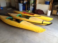
I was expecting a high-adventure, river expedition. Instead I got exactly what I needed: a super relaxing 3 days floating on a river. It felt like i was on a lazy river at a waterpark, in my boat. We didn't have to paddle much at all. It was a relaxing, leisure float. I often fell asleep on my one-man boat, only to wake up 30 min farther downstream. I'm glad we weren't on the river for more than 3 days because I was starting to go stir crazy (ADHD remember). The hikes weren't that spectacular, but the trip was still probably the highlight of the year for me. It was beautiful to see all of these areas from a new vantage point. I'd find a way to make those DIY kayaks as comfortable as possible. You'll be sitting for many hours a day. Fortunately our boats were big enough to completely lie down.

Hearing the echoes was cool, but seeing the wildlife was even cooler. We saw herons, river otters, owls, bats, duck, geese, lizards, snakes, and all sorts of cool bugs.

We will definitely be back annually, though I'll probably try the colorado next year for a change of pace. I second the suggestion to put in directly at Ruby Ranch. There was a big gate with a "no trespassing" sign that you have to go through to get to Ruby Ranch. i expected a big commercial operation at Ruby Ranch, but it was just a small ma and pa property where you leave your money in a box and take care of everything else yourself.

Hope that helps.
 
Take it slow, watch for other drivers and try not to roast your brakes.
Ok thanks for that tip! I'm thinking instead of driving the trailer down, we'll just use the pick up and do multiple trips if needed.

I think you have a good feel for the trip but risk over planning. Don't worry about seeing everything, just enjoy the adventure.
Such is my nature . . . but thanks for the reminder. When I have taken my own kids or groups of scouts on such activities I have this compulsion to create a "perfect trip." My end game is in 10 years when, hopefully, these kids come to me and say, "remember that Green River trip we took . . . " But that's beyond the scope of this forum. Thanks again for the remidner.
 
@sixstringsteve Thanks for the up to date info. Your description of the road down, the mud & the tamarisk Have me thinking... I'm pleased to hear the flows are good. As mild as the snow was this year - I was concerned that we'd have to be constantly paddling.

The drive down doesn't concern me - it is pulling a trailer up & down that does and I think you've changed my mind on that - I'm the worlds worst trailer backer upper so I think I'll just leave the trailer at the top - is that possible?

I'm anticipating 3-4 mph travel - would that be a fair estimation?
 
Keep in mind the flows are probably much higher right now than they will be for you in June. It was raining up north most of the time, which added to the flow. In my estimation, we were going 1.5-2 mph on the river.

Yes, you can leave a trailer at the top of the switchbacks, there's a dirt parking lot there.
 
@sixstringsteve Thanks for the up to date info. Your description of the road down, the mud & the tamarisk Have me thinking... I'm pleased to hear the flows are good. As mild as the snow was this year - I was concerned that we'd have to be constantly paddling.

The drive down doesn't concern me - it is pulling a trailer up & down that does and I think you've changed my mind on that
I'm anticipating 3-4 mph travel - would that be a fair estimation?

I've towed trailers down there. As long as you have a little ground clearance and it isn't raining, it is no sweat. It is pretty far to the ramp from the rim - maybe 5 miles?

As a reference, some of the guide companies take small school busses down it. The biggest issue is actually having to pass anyone, especially one of the busses on the switchbacks. Keep your eyes open on the way down so you can find a place to stop where it is wide enough for two!
 
I've towed trailers down there. As long as you have a little ground clearance and it isn't raining, it is no sweat.
Good to know. We'll use a standard Chevy PU for the trailer. If it has rained, what are your suggestions on how long to wait? Or is it just a matter of not going down during an active rain? I'm probably worrying about this more than I should, but I was looking at the Google Earth images and I'll admit, I got nervous.
 
yup, you're overthinking it. When you get there you'll know if it's sketchy or not. You have a couple miles of dirt road before you get to the switchbacks. If it's slippery and slimy on the flat part, I'd stay away from the switchbacks. If it's wet, you can make a judgement call when you get there.
 
Bring a machete. Seriously. There were some great campsites that were buried behind 20 feet of tamarisk. I'd love to see a group of scouts do a service project and go in there and hack away a few new paths to the good campsites.

I'll talk to the rangers and see what they say.
 
The drive down to Mineral Bottom depends largely on your vehicle. It's steep with significant drop-offs but is generally well maintained. Take it slow, watch for other drivers and try not to roast your brakes.

The easiest/best way to do this is downshift and let your engine do some of the braking. Put it in first and your brakes will thank you! Way too many noobs keep their car in drive and ride the brakes down any sort of hill. Not the smartest way to go about it IMO.
 
The easiest/best way to do this is downshift and let your engine do some of the braking. Put it in first and your brakes will thank you! Way too many noobs keep their car in drive and ride the brakes down any sort of hill. Not the smartest way to go about it IMO.

Brakes are cheaper than transmissions. But yes, careful engine braking is useful.
 
I've got hard copies of the plans . . . if you're really interested I'll see about getting them scanned (they're on a page that's around 4'x3').
 
i'll hit you up if our scouts decide to build something similar. no rush, I was just curious where you found those plans.
 
My skinboat looks similar. What did you choose for the coverings? I'd originally had painted canvas but switched up to poly-coated ballistic nylon when I re-skinned it last year.
 
My skinboat looks similar. What did you choose for the coverings?

Sadly, I have no idea what the material is. A friend of a friend donated it when we built these. It's some kind of plastic of a moderate gauge that came on an industrial size roll.
 
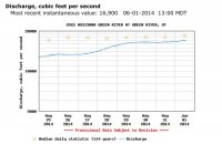
I'm looking at Green River flow rates. @sixstringsteve mentioned flows being 6-13k cfs when he was there the first weekend in May. This where the river is now
image.jpg

image.jpg

As of today, June 1, it's at 17k cfs without sign of having reached its max. Those of you who have done this trip what is the ideal flow rate? Is there any chance it will drop to that in the next two weeks? Is there a flow where it's just too high to have
an enjoyable trip?

As always, thanks for your input.
 
Similar threads
Thread starter Title Forum Replies Date
fossana Favorite map resources General Discussion 17
forest dweller Favorite backpacking foods...convenient, easy, delicious, nutritious? General Discussion 20
Ellen What are your favorite spots to hike and camp in December? Trip Planning 10
montanaclimber Americans: where was your favorite international backpacking trip? Trip Planning 25
Mikjik86 Favorite location with no cell phone service General Discussion 56
U Favorite sites in Glacier in North Fork, Lake McDonald or Cole/Nyack? Looking at mid july Trip Planning 2
U Favorite Yellowstone Gallatin Mtn Area Campsite? Looking at WD5, WE7 and that area Trip Planning 5
J Three of my Favorite Things: Hiko Springs, NV. Narrows, peaks, petroglyph hike Hiking & Camping 0
Strawsome Favorite 2-3 day backpacking trip. Trip Planning 8
Parma Favorite Maze Campsites General Discussion 1
D Greetings from Missouri! What are your favorite Hikes in the Sawtooths? Noobs: Introduce yourself! 4
Strawsome What is your favorite hike in the Escalante/Hole in the rock road area? General Discussion 6
RussRDH Returning to my favorite past-time Noobs: Introduce yourself! 1
Nick Album Your favorite shots from 2015 Photography 126
DrNed Your Most Important or Favorite Wilderness Skill General Discussion 42
L Favorite food in the woods General Discussion 6
Nick Album Your favorite shots of 2014 Photography 49
Parma New Favorite Toy General Discussion 2
steve Where are your favorite primitive camping spots near Capitol Reef/Torrey? General Discussion 6
IntrepidXJ My Ten Favorite Photos of 2013 Photography 0
Nick Album Your favorite shots of 2013 Photography 47
Nick Favorite Trips of 2012 General Discussion 9
Dan What's your favorite recipe for cooking backcountry fish? General Discussion 15
Seldom Seen Anderson Favorite Books General Discussion 21
Deadeye008 What's your favorite backcountry lens? Photography 16
Rockskipper Solar flare = aurora in many places next couple of nights General Discussion 5
balzaccom Places to stop along the way Trip Planning 3
Ross Permit places available for a Cape Solitude/Comanche Pt Grand Canyon backpack (+Canaan Mountain) Meet Up (Members Only) 0
Brad Going places Noobs: Introduce yourself! 4
Parma Places to eat in Torrey? General Discussion 3
JohnP Labor Day Weekend : UT "Hiding" Places Trip Planning 4
SirDonB Album People or Places Pics Photography 4
Nick Great places to live for outdoors lovers General Discussion 51
Dan Epic Flash Floods - Top 5 Places to Watch the Mayhem General Discussion 11
uintahiker Places to get free firewood- place them here! General Discussion 4
Sandro Suggestions: hikes and places to visit around Kanab General Discussion 5
Dave Utah "Faces in Places" contest Photography 5
J Grand Canyon NP Backpack Pt. 2 Deer Cyn explore-->Esplanade-->Indian Hollow Tr. April 18-23, 2021 Backpacking 10
steve The More We Explore - Video Trip Reports Backpacking 32
Upgrayedd Areas to hike, camp and explore with small children within 3 hours of Salt Lake. Trip Planning 13
pixie1339 Flickr Explore Photography 13

Similar threads

Back
Top