Navigation
Install the app
How to install the app on iOS
Follow along with the video below to see how to install our site as a web app on your home screen.
Note: This feature may not be available in some browsers.
More options
Style variation
You are using an out of date browser. It may not display this or other websites correctly.
You should upgrade or use an alternative browser.
You should upgrade or use an alternative browser.
Exploring/Calf Creek
- Thread starter MikeP
- Start date
canadug
Member
- Joined
- Nov 26, 2015
- Messages
- 213
Canadug = Vancouver, Canada........ I try to make it down to Utah every March provided it is still not Winter-likeThat's the way I see it as well. Does "Canadug" mean you're from Canada? Southern Utah and the Canadian Rockies are my two favorite places to hike. I have more trips lined up in those two places than I have time left in my useful hiking career.
canadug
Member
- Joined
- Nov 26, 2015
- Messages
- 213
Where do you live?That branch looks like a pour-off in the sat view. It looks like there may be some more promising opportunities further south though.
View attachment 118389
MikeP
Member
- Joined
- Dec 18, 2017
- Messages
- 19
Chicago. Friend of mine is Canadian and bought a place in Canmore a few years ago. So my hiking life now is - Summer hike in the Canadian Rockies, Spring or Fall in Southern Utah. I imagine I'll do that every year as long as the good lord allows. Hike this summer still to be determined (Parks Canada slow in opening up the reservation system this year), but we may well wind up in BC. For anyone who needs a little inspiration to do some hiking up north, below is a picture from last year's hike. This could be done as a very simple over-nighter if you want, and you'll share the place with eight or ten other people tops. As opposed to say, Lake Louise, which is even more overrun with people than Bryce or Zion,

- Joined
- Dec 2, 2019
- Messages
- 212
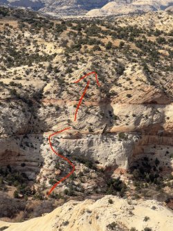
I recently had the chance to check out the potential route out of the Calf Creek drainage, to reach the higher benches (from the trail heading to the lower falls) that we discussed earlier this year.
And, the good news is: It goes !
The lower section is very straightforward; just a walk up a sandstone slope really. The upper part is a little trickier though, since the slickrock gets considerably steeper, and angles away awkwardly. However, with a decent pair of sticky shoes and a degree of confidence, it's perfectly manageable for the hiker with some experience in traversing slickrock.
I did, of course, in my excitement at reaching the top, forget exactly what my initial ascent route was, and spent my usual 10 minutes staring over the edge, wondering how I would get down") ... I then built a cairn for future reference !
... I then built a cairn for future reference !
Kudos to the Gaia GPS slope-angle tool, for allowing us to locate the potential route on a 2D map.
I've attached a few photos from the hike up the slope, and from the top looking north. Unfortunately, it was late in the afternoon when I visited, so I didn't have the chance to hike much further, but it did look that there were some cool areas to explore up there.
.
.

.
.

.
.

And, the good news is: It goes !
The lower section is very straightforward; just a walk up a sandstone slope really. The upper part is a little trickier though, since the slickrock gets considerably steeper, and angles away awkwardly. However, with a decent pair of sticky shoes and a degree of confidence, it's perfectly manageable for the hiker with some experience in traversing slickrock.
I did, of course, in my excitement at reaching the top, forget exactly what my initial ascent route was, and spent my usual 10 minutes staring over the edge, wondering how I would get down
... I then built a cairn for future reference !Kudos to the Gaia GPS slope-angle tool, for allowing us to locate the potential route on a 2D map.
I've attached a few photos from the hike up the slope, and from the top looking north. Unfortunately, it was late in the afternoon when I visited, so I didn't have the chance to hike much further, but it did look that there were some cool areas to explore up there.
.
.
.
.
.
.
canadug
Member
- Joined
- Nov 26, 2015
- Messages
- 213
Live in Vancouver........Rockies are pretty sweet for sure.That's the way I see it as well. Does "Canadug" mean you're from Canada? Southern Utah and the Canadian Rockies are my two favorite places to hike. I have more trips lined up in those two places than I have time left in my useful hiking career.
jholmes01
Member
- Joined
- Nov 10, 2020
- Messages
- 226
Thanks for closing the loop on this. It's always nice to find out whether something that looks like it might go on a map actually does. I don't suppose you captured an actual track of your route up? I guess if you did, it wouldn't have been quite as challenging to find it on the way back down...I recently had the chance to check out the potential route out of the Calf Creek drainage, to reach the higher benches (from the trail heading to the lower falls) that we discussed earlier this year.
And, the good news is: It goes !
The lower section is very straightforward; just a walk up a sandstone slope really. The upper part is a little trickier though, since the slickrock gets considerably steeper, and angles away awkwardly. However, with a decent pair of sticky shoes and a degree of confidence, it's perfectly manageable for the hiker with some experience in traversing slickrock.
I did, of course, in my excitement at reaching the top, forget exactly what my initial ascent route was, and spent my usual 10 minutes staring over the edge, wondering how I would get down
Kudos to the Gaia GPS slope-angle tool, for allowing us to locate the potential route on a 2D map.
I've attached a few photos from the hike up the slope, and from the top looking north. Unfortunately, it was late in the afternoon when I visited, so I didn't have the chance to hike much further, but it did look that there were some cool areas to explore up there.
.
.
View attachment 126880
.
.
View attachment 126881
.
.
View attachment 126882
I've found the slope angle shading to be incredibly valuable in planning off trail routes, i.e., "if it's green it goes". Example: